Search Britannica
Click here to search
Search Britannica
Click here to search
SUBSCRIBE
SUBSCRIBE
Login
https://premium.britannica.com/premium-membership/?utm_source=premium&utm_medium=nav-login-box&utm_campaign=evergreen
SUBSCRIBE
Home
History & Society
Science & Tech
Biographies
Animals & Nature
Geography & Travel
Arts & Culture
ProCon
Money
Games & Quizzes
Videos
On This Day
One Good Fact
Dictionary
New Articles
History & Society
Lifestyles & Social Issues
Philosophy & Religion
Politics, Law & Government
World History
Science & Tech
Health & Medicine
Science
Technology
Biographies
Browse Biographies
Animals & Nature
Birds, Reptiles & Other Vertebrates
Bugs, Mollusks & Other Invertebrates
Environment
Fossils & Geologic Time
Mammals
Plants
Geography & Travel
Geography & Travel
Arts & Culture
Entertainment & Pop Culture
Literature
Sports & Recreation
Visual Arts
Image Galleries
Podcasts
Summaries
Top Questions
Britannica Kids
Ask the Chatbot
Games & Quizzes
History & Society
Science & Tech
Biographies
Animals & Nature
Geography & Travel
Arts & Culture
ProCon
Money
Videos
map
Table of Contents
Introduction
History of cartography
Maps and geography in the ancient world
Greek maps and geography
The Roman period
The Middle Ages
The age of discovery and exploration
Revival of Ptolemy
Maps of the discoveries
18th century to the present
The rise of national surveys
International Map of the World (IMW)
World War II and after
Mapmaking
Elements
Map scales and classifications
Map projections
Development of reference spheroids
Geographic and plane coordinate systems
Basic data for compilation
Symbolization
Nomenclature
Types and uses of maps and charts
World status of mapping and basic data
Types of maps and charts available
Government and other mapping agencies
International organizations
Modern mapmaking techniques
Compilation from existing materials
Generalization of detail
Map production from original surveys
Final steps in map preparation
Scribing
Nautical charts
Automation in mapping
References & Edit History
Related Topics
Images
For Students
map summary
Contents
Home
Geography & Travel
Human Geography
map: Media
cartography
Share
Share
Share to social media
Facebook
X
URL
https://www.britannica.com/science/map/images-videos
Images
topographic map
Topographic map.
© genedailey/stock.adobe.com
globe
A globe.
© Svetlana Lukienko/stock.adobe.com
Herodotus' map of the world
Figure 1: Herodotus' map of the world.
Library of Congress, Washington, D.C.
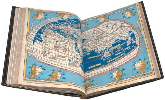
Ptolemy's world map
Ptolemy's map of the world, originally created in the 2nd century ce;...
Library of Congress, Washington, D.C.
Ptolemy's
Geographia
Map of Great Britain and Ireland derived from Ptolemy's
Geographia
, woodcut,...
The Newberry Library, Gift of Edward E. Ayer, 1911 (
A Britannica Publishing Partner
)
world map derived from Ptolemy's
Geographia
World map derived from Ptolemy's
Geographia
, woodcut, 1482. It was included...
The Newberry Library, Gift of Edward E. Ayer, 1912 (
A Britannica Publishing Partner
)
Speculum orbis terrarum
Map depicting a portion of North America from Gerard de Jode's atlas
Speculum...
The Newberry Library, Gift of Edward E. Ayer (
A Britannica Publishing Partner
)
Theatrum orbis terrarum
Map depicting North and South America, in an edition of Abraham Ortelius's
Theatrum...
The Newberry Library, Ayer Fund, 1920 (
A Britannica Publishing Partner
)
Atlante Veneto
Map of North America from Vincenzo Coronelli's
Atlante Veneto
, 1690.
The Newberry Library, Gift of Edward E. Ayer (
A Britannica Publishing Partner
)
topographic map
Topographic map.
Kbh3rd and U.S. Geological Survey
VIEW MORE
in these related Britannica articles:
Media for: topographic map
Media for: globe
Media for: world map
Media for: contour line