SlideShare a Scribd company logo
Development and Initial
Testing of an Autonomous
Surface Vehicle for Shallow
Water Mapping
Presenter :
Mohamad Hilmi Mat Idris
M.H. Mat Idris *, M.I. Sahalan,M.A. Abdullah, Z.Z. Abidin
Autonomous Agent Research Group (AARG), Department of
Mechatronics Engineering.
Kulliyyah of Engineering, International Islamic University of Malaysia,
53100 Selangor Malaysia
Presentation Outline
• Introduction
• System Design
• Mechanical consideration
• On-board computer and communication
• Power supply
• Navigation
• Sensors Integration
• Data Logging
• Payload
• Result
• Conclusion and Future Work
Introduction
• Shallow water mapping - process to measure and map
the shape of the coastal, lake, dam or waterway.
• Importance of ‘shallow water mapping’
• Marine and freshwater resources and ecosystems are now recognized
as ranking among the world’s most valuable assets.
• We need bathymetry/depth information to
• Manage environmental hazards (from coastal erosion to tsunami).
• Sedimentation monitoring, volume calculation (river, dam).
• Underwater construction (dams, bridges, marinas, coastal
protection)
• Conventional method
• 1) Hydrography ship 2) Satellite 3) LiDaR
• Drawback of current method aka ‘gap’
• Non capable for shallow and high turbidity and tight area.
• Proposed solution
• Small portable Autonomous Surface Vessel ( which later called ‘ASV’).
System development
• ASV Initial Specification
Item Specification
Hull Configuration Catamaran
Dimension
1170mm x 360mm x
150mm
Turning diameter 2m
Max Payload 10kg
Average speed 4.5kt
Operation time 3hours
• Mechanical consideration
• Hull Type Selection (Catamaran vs Monohull)
• Better Roll and pitch stability.
Catamaran (top) vs Monohull (bottom) stability comparison
System development
• Mechanical consideration
• Hull Type Selection (Catamaran vs. Mono-hull)
• Easy access to water ( for underwater
sensors)
• Less drag force compare to mono-hull (more
energy saving)
• Hull Material type(fiber glass)
• Robust for field deployment
System development
• On-board computer and communication
Base station (autonomous)
• Laptop (Matlab GUI)
• BlackBox RF Modem
Base station (manual)
• Futaba RC Transmitter
On-board Electronics
• Blackbox RF modem
• Futaba RC Receiver
• Arduino Mega
Payload Sensor
• GPS, Sonar, Compass,
Probes (Serial RS232-
NMEA 1803)
System development
• Power supply
• Two types of batteries (estimate 3 hours operation*)
• 12V/4000mAH LiPo batteries connected in series,
providing 24V nominal voltage for propeller
• 12V 9800mAH battery pack. Additional DC/DC
converter is used to provide power sharing
between the devices.
12V Litium-Ion
Capacity : 9800mAH
12V Litium Polimer
Capacity : 4000mAH
System development
• Navigation
• Garmin eTrex® H, a high-
sensitivity GPS receiver that can to
lock onto satellite signals quickly
and maintain accuracy up to ±3m
during clear view sky.
• KVH C100 Fluxgate Industrial-
grade compass module that has
accuracy up to 0.1°, ±0.5°
resolution, ±45° tilt angle
compensation and 1 second
response time
• Both sensors are RS-232 and
NMEA 0183 compatible for easy
integration.
Waypoint navigation flowchart
System development
• Payload and Sensors Integrations
• AtlasScientific water probes (e.g. pH, conductivity, dissolve
oxygen, and oxidation reduction potential)
Water Probes
Sonar Sensor
GPS
NMEA 1803
NMEA DATA
COMBINER Micro Controller
Data Parsing and
data logging
SD card
module
RF Transceiver
System development
• Maneuvering Test
• Straight line test
• Using RC operation
• Max speed : 8m/s
• Bad reverse thrust
• Circle Maneuver
• Minimum turning diameter : 4meter
• Fairly enough for survey operation (lawn mower)
• 360 rotation if more preferable for very tight area.
Result of Experimentation Test
• Sensors Reading and Logging
$GPGSV,3,3,11,30,30,175,35,07,05,153,00,09,13,119,
00*4B
$PENV,7.00,8.19,272.28,12.36,6,0.00,1.000*51
$SDMTW,023.1,C*34
//Channel 0 @ pH
7.00
//Channel 1 @ Dissolve Oxygen
8.19
//Channel 2 @ Oxidation Reduction
Potential
272.28
//Channel 3 @ Conductivity
12.36,6,0.00,1.00
Raw Data
Excel Format Data
Result of Experimentation Test
• Field Test (Plot of data)
• Swimming Pool Test, IIUM Sport Complex
• Small Pond, NAHRIM
• Maryam Lake, IIUM
Person Monitoring Data
at Base Station
Field test devices setup
Result of Experimentation Test
Depth Swimming Pool,
IIUM Sport Complex
Depth plot Small Pond,
NAHRIM
Result of Experimentation Test
Depth plot at Maryam Lake, IIUM
Result of Experimentation Test
• Conclusion
• Small portable ASV had proven to fill the gap between LIDAR,
satellite bathymetry and hydrographic vessel.
• The catamaran hull provide platform stability to enhance
performance of data measurement.
• The mission test and real scenario trial proved the operability of
the ASV for a shallow water mapping operation.
• In its current form, the boat meets its design objectives by its
capability of safely maneuver at a very shallow and tight area
while collecting bathymetry data.
• Future work
• Development of additional payload modules.
• upgrade of navigation sensors
• incorporation of robust navigational controller to enhance
performance in strong current and wind
• the used of vision-based navigation system in negotiation above
and below water obstacles
Conclusion and Future Work

More Related Content

PDF
Chetan soni
PDF
Project Summary_Anand Sundaresan
PDF
Profiling Floats and Gliders/AUVs Powered by Ocean Temperature Differential
PDF
Stormwater 2016 Conference_Drone Trial
PPTX
AVORA I successful participation in SAUC-E'12
PPTX
Underwater wireless sensor networks
PDF
Kongsberg Maritime AUVs
PPTX
"Click here" to build your UAV
Chetan soni
Project Summary_Anand Sundaresan
Profiling Floats and Gliders/AUVs Powered by Ocean Temperature Differential
Stormwater 2016 Conference_Drone Trial
AVORA I successful participation in SAUC-E'12
Underwater wireless sensor networks
Kongsberg Maritime AUVs
"Click here" to build your UAV

What's hot (20)

PPT
Underground survey
PDF
DSD-INT 2015 - Operational system for the eThekwini municipality - Angus Gowar
PDF
DSD-INT 2015 - Satellite based near-real time information services for aquati...
PPTX
Underground utility survey
PPSX
A Strategy for Reliability Evaluation and Fault Diagnosis of Autonomous Under...
PPTX
HIGH RESOLUTION SATELLITE SYSTEM
PDF
MobileMT airborne surveys
PPTX
Underwater robot
PPTX
Autonomous Unmanned Vehicles
PDF
Maritime Robotics
PDF
637124main staehle presentation
PDF
Underwater Robotics
PPTX
GPS & its application in mining
PDF
2013_UTS_Fall_web
PDF
Hydrographic Surveyor | Functions, Roles and Responsibilities
PDF
Automated Motion Detection from space in sea surveillance
PDF
Bridge Assessment & Monitoring
PDF
Analysis on Data Transmission in Underwater Acoustic Sensor Network for Compl...
PDF
Inertial Navigation for Quadrotor Using Kalman Filter with Drift Compensation
PPT
Ionosphere Model and Tomography
Underground survey
DSD-INT 2015 - Operational system for the eThekwini municipality - Angus Gowar
DSD-INT 2015 - Satellite based near-real time information services for aquati...
Underground utility survey
A Strategy for Reliability Evaluation and Fault Diagnosis of Autonomous Under...
HIGH RESOLUTION SATELLITE SYSTEM
MobileMT airborne surveys
Underwater robot
Autonomous Unmanned Vehicles
Maritime Robotics
637124main staehle presentation
Underwater Robotics
GPS & its application in mining
2013_UTS_Fall_web
Hydrographic Surveyor | Functions, Roles and Responsibilities
Automated Motion Detection from space in sea surveillance
Bridge Assessment & Monitoring
Analysis on Data Transmission in Underwater Acoustic Sensor Network for Compl...
Inertial Navigation for Quadrotor Using Kalman Filter with Drift Compensation
Ionosphere Model and Tomography
Ad

Similar to Development and Initial Testing of an Autonomous Surface (20)

PDF
10 - Xylem River Water Monitoring WORLD BANK-Sep-15
PDF
10121-4504-01-PR-Final_Intelligent_Casing-Intelligent_Formation_Telemetry_Sys...
PPTX
IoT Architecture for Water Resources Industry
PPTX
Multibeam Advisory Committee - 2016 UNOLS FIC Meeting
PDF
Acoustic doppler current profiler (adcp)
PPTX
UNDER WATER WIRELESS COMMUNICATION
PPT
A Platform for Data Intensive Services Enabled by Next Generation Dynamic Opt...
PPTX
[DSC Europe 24] Marina Ivasic Kos - AI in maritime - Autonomous ships
PDF
Well logging
PDF
Full Scale Data Handling in Shipping: A Big Data Solution
PPTX
Smart technology for Water Use Efficiency ClimaAdapt
PPTX
Water quality monitoring based on small satellite technology 1
PDF
7 - AECOM Water Resources Seminar World Bank -16-Sept
PDF
ACOUSTIC SYSTEM FOR HIGH-ACCURACY POSITIONING SOLUTIONS
PPTX
Search and rescue
PPTX
Automatic plant watering system using GSM and moisture sensors.
PDF
TeamSurv presentation to UK Hydrographic Society, 2011
PPTX
underwater_wireless_communication_networ.pptx
PPTX
rajat Ppt mwc.pptx
PDF
TGS Arcis- Canada Arcis Processing Services Brochure
 
10 - Xylem River Water Monitoring WORLD BANK-Sep-15
10121-4504-01-PR-Final_Intelligent_Casing-Intelligent_Formation_Telemetry_Sys...
IoT Architecture for Water Resources Industry
Multibeam Advisory Committee - 2016 UNOLS FIC Meeting
Acoustic doppler current profiler (adcp)
UNDER WATER WIRELESS COMMUNICATION
A Platform for Data Intensive Services Enabled by Next Generation Dynamic Opt...
[DSC Europe 24] Marina Ivasic Kos - AI in maritime - Autonomous ships
Well logging
Full Scale Data Handling in Shipping: A Big Data Solution
Smart technology for Water Use Efficiency ClimaAdapt
Water quality monitoring based on small satellite technology 1
7 - AECOM Water Resources Seminar World Bank -16-Sept
ACOUSTIC SYSTEM FOR HIGH-ACCURACY POSITIONING SOLUTIONS
Search and rescue
Automatic plant watering system using GSM and moisture sensors.
TeamSurv presentation to UK Hydrographic Society, 2011
underwater_wireless_communication_networ.pptx
rajat Ppt mwc.pptx
TGS Arcis- Canada Arcis Processing Services Brochure
 
Ad

Development and Initial Testing of an Autonomous Surface

  • 1. Development and Initial Testing of an Autonomous Surface Vehicle for Shallow Water Mapping Presenter : Mohamad Hilmi Mat Idris M.H. Mat Idris *, M.I. Sahalan,M.A. Abdullah, Z.Z. Abidin Autonomous Agent Research Group (AARG), Department of Mechatronics Engineering. Kulliyyah of Engineering, International Islamic University of Malaysia, 53100 Selangor Malaysia
  • 2. Presentation Outline • Introduction • System Design • Mechanical consideration • On-board computer and communication • Power supply • Navigation • Sensors Integration • Data Logging • Payload • Result • Conclusion and Future Work
  • 3. Introduction • Shallow water mapping - process to measure and map the shape of the coastal, lake, dam or waterway. • Importance of ‘shallow water mapping’ • Marine and freshwater resources and ecosystems are now recognized as ranking among the world’s most valuable assets. • We need bathymetry/depth information to • Manage environmental hazards (from coastal erosion to tsunami). • Sedimentation monitoring, volume calculation (river, dam). • Underwater construction (dams, bridges, marinas, coastal protection) • Conventional method • 1) Hydrography ship 2) Satellite 3) LiDaR • Drawback of current method aka ‘gap’ • Non capable for shallow and high turbidity and tight area. • Proposed solution • Small portable Autonomous Surface Vessel ( which later called ‘ASV’).
  • 4. System development • ASV Initial Specification Item Specification Hull Configuration Catamaran Dimension 1170mm x 360mm x 150mm Turning diameter 2m Max Payload 10kg Average speed 4.5kt Operation time 3hours
  • 5. • Mechanical consideration • Hull Type Selection (Catamaran vs Monohull) • Better Roll and pitch stability. Catamaran (top) vs Monohull (bottom) stability comparison System development
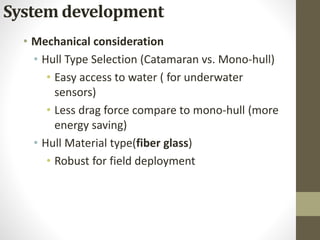
  • 6. • Mechanical consideration • Hull Type Selection (Catamaran vs. Mono-hull) • Easy access to water ( for underwater sensors) • Less drag force compare to mono-hull (more energy saving) • Hull Material type(fiber glass) • Robust for field deployment System development
  • 7. • On-board computer and communication Base station (autonomous) • Laptop (Matlab GUI) • BlackBox RF Modem Base station (manual) • Futaba RC Transmitter On-board Electronics • Blackbox RF modem • Futaba RC Receiver • Arduino Mega Payload Sensor • GPS, Sonar, Compass, Probes (Serial RS232- NMEA 1803) System development
  • 8. • Power supply • Two types of batteries (estimate 3 hours operation*) • 12V/4000mAH LiPo batteries connected in series, providing 24V nominal voltage for propeller • 12V 9800mAH battery pack. Additional DC/DC converter is used to provide power sharing between the devices. 12V Litium-Ion Capacity : 9800mAH 12V Litium Polimer Capacity : 4000mAH System development
  • 9. • Navigation • Garmin eTrex® H, a high- sensitivity GPS receiver that can to lock onto satellite signals quickly and maintain accuracy up to ±3m during clear view sky. • KVH C100 Fluxgate Industrial- grade compass module that has accuracy up to 0.1°, ±0.5° resolution, ±45° tilt angle compensation and 1 second response time • Both sensors are RS-232 and NMEA 0183 compatible for easy integration. Waypoint navigation flowchart System development
  • 10. • Payload and Sensors Integrations • AtlasScientific water probes (e.g. pH, conductivity, dissolve oxygen, and oxidation reduction potential) Water Probes Sonar Sensor GPS NMEA 1803 NMEA DATA COMBINER Micro Controller Data Parsing and data logging SD card module RF Transceiver System development
  • 11. • Maneuvering Test • Straight line test • Using RC operation • Max speed : 8m/s • Bad reverse thrust • Circle Maneuver • Minimum turning diameter : 4meter • Fairly enough for survey operation (lawn mower) • 360 rotation if more preferable for very tight area. Result of Experimentation Test
  • 12. • Sensors Reading and Logging $GPGSV,3,3,11,30,30,175,35,07,05,153,00,09,13,119, 00*4B $PENV,7.00,8.19,272.28,12.36,6,0.00,1.000*51 $SDMTW,023.1,C*34 //Channel 0 @ pH 7.00 //Channel 1 @ Dissolve Oxygen 8.19 //Channel 2 @ Oxidation Reduction Potential 272.28 //Channel 3 @ Conductivity 12.36,6,0.00,1.00 Raw Data Excel Format Data Result of Experimentation Test
  • 13. • Field Test (Plot of data) • Swimming Pool Test, IIUM Sport Complex • Small Pond, NAHRIM • Maryam Lake, IIUM Person Monitoring Data at Base Station Field test devices setup Result of Experimentation Test
  • 14. Depth Swimming Pool, IIUM Sport Complex Depth plot Small Pond, NAHRIM Result of Experimentation Test
  • 15. Depth plot at Maryam Lake, IIUM Result of Experimentation Test
  • 16. • Conclusion • Small portable ASV had proven to fill the gap between LIDAR, satellite bathymetry and hydrographic vessel. • The catamaran hull provide platform stability to enhance performance of data measurement. • The mission test and real scenario trial proved the operability of the ASV for a shallow water mapping operation. • In its current form, the boat meets its design objectives by its capability of safely maneuver at a very shallow and tight area while collecting bathymetry data. • Future work • Development of additional payload modules. • upgrade of navigation sensors • incorporation of robust navigational controller to enhance performance in strong current and wind • the used of vision-based navigation system in negotiation above and below water obstacles Conclusion and Future Work