SlideShare a Scribd company logo
Indonesia Space Activities
Prof. Dr. Thomas Djamaluddin
Introduction
Space technology and information technology are the most important
technololgies in modern life, not only in global and national scale, but also
in personal activities.
Space technology is used for telecommunication, survaillance, and
navigation. Indonesia as maritime continent, with 13,466 named islands
(~17,000 islands, including no-name islands) needs space technology.
Since space technology is close
related to aeronautics
technology, Indonesia has
“National Institute of
Aeronautics and Space”, in
which space and aeronatics
(aerospace) science and
technology developments, as
well as policy studies, are
conducted.
A Brief History of Aerospace Activities
in Indonesia
• The Aviation Board was established on 1955 based on
Government Regulation No. 5/1955. This board later
changed to become the National Aeronautics and Space
Council of the Republic of Indonesia (DEPANRI) by
Presidential Decree No. 99/1993. DEPANRI is chaired by the
President of Republic of Indonesia with members consisting
of State Minitry of Research and Technology (also as vice
chairman and acting chairman), Minister of Foreign Affairs,
Minister of Trade and Industry, Minister of Defence, and
State Minister of Development Planning.
• Space technology activities in Indonesia started in the 1960s.
In 1962 PRIMA (Proyek Roket Ilmiah dan Militer Awal) – the
Primilinary Project on Scientific and Military Rocket was
stared. The first rocket produced by this project (i.e. Kartika)
was launched on 14 August 1964 from Launching Station at
Pameungpeuk, West Java.
• National Institute of Aeronautics and Space (LAPAN) was
established based on Presidential Decree No. 236/1963.
• In 1976 Indonesia became the third country using
telecommunication satellite, PALAPA.
• Space Law No.
21/2013 was enacted
on 6 August 2013.
A Brief History of Aerospace Policies
in Indonesia
Indonesian Space Policies
in Space Law No. 21/ 2013
• The space law consists of general policies related to space activities,
i.e. space science, remote sensing, aerospace technology mastery,
space launch and space commercial activities.
• LAPAN as government institution has authority to conduct of all
space activities in Indonesia, in addition to current duty as aerospace
research and development institution.
• LAPAN is directly responsible to the President of Indonesia, while its
activities are technically coordinated by a ministry for research and
technology.
• The space law is intended to promote self-sufficiency and national
competitiveness, to encourage space exploration and utilization for
national prosperity and productivity, to ensure space activity
sustainability, to provide law basis for space activities, to ensure
security and safety in space activities, to ensure the implementation
of international agreement, and to support national defence and
integrity.
STRUKTUR ORGANISASI
LAPAN MAIN COMPETENCES
SPACE SCIENCE &
ATMOSPHERIC
SCIENCE
AERONAUTICS &
SPACE TECHNOLOGY
REMOTE SENSING AERONAUTICS &
SPACE POLICY
Development of National
capability in utilizing of
remote sensing technology
for earth observation with
focus on development of
National Remote Sensing
Data Bank to support data
needs from Ministry, Local
Goverment, Military and
Police.
Development of
Unmanned Air Vehicle
(UAV/drone) & Air
Transport design, Satellite
Development & its
components and sounding
rocket development and its
spin off for peaceful
purposes
Development of Decision
Support System for space
Weather and dynamic of
equator atmosphere
Drafting of Government
Regulation and President
Regulation according to
National Decree on Space
and guidlines in
international forum.
LOCATION OF LAPAN FACILITIES
Jakarta
Rumpin
Bandung
Tanjungsari
Pameungpeuk
Watukosek
Rancabungur
Kototabang
Pontianak
Parepare
Biak
ROAD MAP OF SATELLITE TECHNOLOGY PROGRAM
LAPAN-A2 /
ORARI
LAPAN-A3 /
IPB
LAPAN-A1 /
TUBSAT
Mission Video Surveilence
Earth Surveilance, maritime monitoring,
Amateur Communication
Experimental remote sensing, maritime
monitoring, Science exp.
Payload
Analog Video Camera, Low
resolution VideoCam
Digital Space Camera, Analog Video Camera,
AIS, APRS
4 band pushbroom imager, Hi res DigitalCam,
AIS, APRS
Spectral resolution PAL Camera (752 x 582 pixel) Digital Camera (2048 x 2044 pixel)
Analog Camera (752 x 582 pixel)
450 - 520 nm; 520 - 600 nm;
630 690 nm; 760 - 900 nm
Spatial resolution 5 m ( 3,5 km swath),
200m (80 km swath)
4 m (7 km swath),
5 m (3,5 km swath)
18 m (100 km swath) / 4 m (7 km)
Orbit 635 km, 97,6 deg 650 km, 8 deg, Near-Equatorial 650 km, 97,6 deg
Data TX, and
TT&C
S-Band : 2220 MHz,
UHF : 437,325 MHz
S-Band : 2220 MHz,
UHF : 437,425 MHz
X-Band : 8116 - 8284 MHz,
UHF : 437,325 MHz
Downlink rate 5 Mbps 5 Mbps 105 Mbps
Total weight 57 kg 74 kg 115 kg
Dimension 450 x 450 x 270 mm 500 x 470 x 360 mm 500 x 500 x 700 mm
Launch 2007 2nd quarter 2015 End of 2015
Mision
Experimental remote sensing
(Validation of Optical data pre-
processing algorithm)
Experimental remote sensing.
(Development of SAR Micro-Sat for Maritime
and agriculture monitoring)
Payload Visible and Near Infrared imager
experimental,
Shyntetic Aperture Radar Experimental
(deployable dimension 450 x 70 cm), AIS
Spectral/discrimina-
tion mode
NIR Bolometer camera, Selectable
with 10 nm interval.
L-band; HH, HV, VH, VV polarimetry
Spatial resoluition 5 m ( 3,5 km swath), 1 km 30 m (100 km)
Orbit 650 km, 97,6 deg 650 km, 97,6 deg
Payload TX, TTC X-band, S-band X-Band, S-band
Downlink rate 200 Mbps 200 Mbps
Dimension Max 60x60x80 cm³ Max 60x60x80 cm³
Weight 150 kg 200 kg
LAPAN-A4
LAPAN-A5
LAPAN’s Equatorial Satellite Mission
• Meanwhile, the temporal resolution of patrol-boat-based radar and AIS receiver is
very low considering the vast water region. Therefore, satellite-based AIS is truly a
solution for Indonesian problem combining with UAV and SAR satellite technology.
• Since Indonesian territory is spread along the equator, LAPAN decide the operation of
maritime surveillance satellite at the beginning at low inclination orbit, so that the
satellite may pass Indonesia as much as SSO orbit pass the North/South pole (14
times in 24 hours at 650 km orbit).
Space-borne AIS for Maritime Surveillance
• AIS (Automatic Identification System) is a system that can monitor ships, based
on GPS and VHF digital communication. It is regulated by IMO to be installed in
ships weighing 300 tons and above.
• By placing AIS receiver on the satellite, its coverage will
be larger compared to the one usually placed on
the seashore by maritime authority.
Technological Feasibility
The development of satellite-based AIS has been done since 2007
by the US military experimental satellite TACSAT-2. At the moment,
commercial entities like Orbcomm, Com Dev, SpaceQuest dan
Kongsberg Seatex has developed satellite AIS receiver.
Plot of AIS Messages Collected by Nano-satellite
Tracking of Ships (NTS) - Canada
Standard AIS can detect 1000 ships by 15 minutes observation (probability >90%)
Space-borne AIS : 2000 ships detection by 10 minutes observation (probability >90%)
Standard AIS
Technological Feasibility
Ship Detection Probability by AIS at 1000 km Altitude
LAPAN-A2 AIS System
Software Processing
G/S Software:
Acquisition Data from G/S Receiver
Process Raw:
• Remove Frame Counter
• Separating AIS Data from Idle Package
• Filtering AIS data with CRC
Formatting AIS Data:
• As Text File
• As Shipplotter Format
• As Ship NMEA Format
• As Google Earth KML Format
• Tracking Special Ship
AIS Data Ground Processing
LAPAN-A2 AIS System
LAPAN-A2 satellite will be launched as auxiliary payload on PSLV
mission at 2nd semester of 2015.
LAPAN-A2 AIS System
LAPAN-A3/IPB SATELLITE
(An Experimental Remote Sensing Satellite)
• Cooperate with Bogor Agricultural University (IPB) for payload
specification
• Orbit: ~650 km, 97,6 deg
• Payload;
 Experimental remote sensing, maritime monitoring, Science exp.
 4 band pushbroom imager (450 - 520 nm; 520 - 600 nm; 630 690 nm; 760 -
900 nm), Hi res DigitalCam, AIS, APRS
 ~18 m (~100 km swath) Multispectral/ ~4 m (~7 km) Matrix RGB
 115 kg
 End of 2015
• Weight: ~115 Kg
Satellite Development Capabilities
• In-house design capabilities
• In-house Satellite Assembly, Integration & Test (AIT) with thermal,
vacuum chamber, Uniform Light Source, 10,000 & 100,000 clean room
class.
• Customize Satellite operation software
• Satellite Platform and structure manufacturing
• TTC and image reception satellite operation
• In-house satellite components development: (Reaction wheels, Magnetic
coils, Star Tracker, On Board Data Handling)
• Image systematic pre-processing, (Geometric, Radiometric correction,
atmosferic refraction & dispersion, blurring distortion, stochastic
distorsion)
AERONAUTICS TECHNOLOGY DEVELOPMENT PROGRAM
LAPAN SURVEILLANCE UAV (LSU)
LSU Program Status
AERONAUTICS TECHNOLOGY DEVELOPMENT PROGRAM
(cont’d)
VARIAN PROTOTYPE LSU
LSU-01
 Wing tail : 1900 mm
 Lenght : 1200 mm
 Take off : launch
 Maximum Payload : 0,5 kg
 Speed : 45 km/jam
 Max speed : 60 km/jam
 Airspeed Stall : 30 km/jam
 Machine : Brushless
 Fuel : Battery
 Max flight time : 50 menit
 Control System :
Take off/landing by remote control &
fly by autonomous
LSU-02
 Wing tail : 2400 mm
 Lenght : 1700 mm
 Maximum Payload : 3 kg
 Speed : 100 km/jam
 Max speed : 150 km/jam
 Airspeed Stall : 40 km/jam
 Machine : 2 Tax 32cc
 Fuel :
Pertamax plus & oli full sintetic
 Tank : 3,5 liter
 Max flight time : 3,8 jam
 Control System :
Take off/landing by remote
control and fly by
autonomous
 LSU-03
 Wing tail : 3500 mm
 Lenght : 2500 mm
 Tail Height : 700 mm
 Center Wing : 900 mm
 Speed : 100 km/jam
 Max speed : 150 km/jam
 Airspeed Stall : 60 km/jam
 Maximum Payload : 10 kg
 Machine : 2 Tax 100cc
 Fuel :
Pertamax Plus & Oli Full Sintetic
 Tank : 7 liter
 Max flight time : 5 jam
 Control System :
Take off/landing by remote control and fly
by autonomous
AERONAUTICS TECHNOLOGY DEVELOPMENT PROGRAM
(cont’d)
VARIAN PROTOTYPE LSU
LSU-04
 Wing tail : 4000 mm
 Lenght : 3200 mm
 MTOW : 65 kg
 Speed : 100 km/jam
 Max speed : 160 km/jam
 Airspeed Stall : 60 km/jam
 Maximum Payload : 18 kg
 Machine : 11 HP
 Tank :
Pertamax plus &oli full sintetic
 Tank : 8 liter
 Max flight time : 6 jam
 Control System:
Take off/landing by remote control &
flight by autonomous
LSU-05
 Wing tail : 5500 mm
 Lenght : 4100 mm
 Height : 1130 mm
 MTOW : 77 kg
 Empty Weight : 31 kg
 Payload Mass : 30 kg
 Fuel : 16 kg
 Take Off Ground Round : 60 meter
 Climb Rate : 600 ft/min
 Range : 840 km
 Endurance : 8 h
 Lending Ground Run : 83 meter
 Ceiling : 12000 ft
 Cruise Altitude : 3000 ft
 Cruise speed : 100km/h
FADEX
 Wing tail : 3500 mm
 Lenght : 2800 mm
 Take Off mass : 10 kg
 Cruise Speed : 160 km/jam
 Cruise Altitude : 1000 m
 Max flight time : 0,5 jam
 Proppeller : Turboshaft
 Machine : 20 HP - 30 cc
 Fuel : gasoline
 Payload : 15 kg
 Tank : 2 liter
 Airframe : Composite
 Control System:
Take off/landing by remote control &
flight by autonomous
AERONAUTICS TECHNOLOGY DEVELOPMENT PROGRAM
(cont’d)
Program LSU progame achievement status
LSU 02 in military 2012-2013
( Ship On Board Take Off and Landing )
Battlefield maping, Dittop AD 1200 Ha (± 7 hours )
MURI record achievment (200 KM Autonumous)
Flood monitoring
REMOTE SENSING DATA
AERONAUTICS TECHNOLOGY DEVELOPMENT PROGRAM
(cont’d)
LAPAN SURVEILLANCE AIRCRAFT (LSA)
AERONAUTICS TECHNOLOGY DEVELOPMENT PROGRAM
(cont’d)
Status program LSA - AADP - UAV Research and Development of UAV :1 ton MTOW
- Light and advanced Aircraft Research and Development
( Autonomous Control & Composite )
- Simulator System
- Capacity Building (Master and Phd)
AERONAUTICS TECHNOLOGY DEVELOPMENT PROGRAM
(cont’d)
LSA’s Program status
Parameter Pengambilan Sample Lapangan
Kondisi periode tanaman padi
Biomas tanaman padi
Tinggi tanaman padi
Kerapatan tanaman
Variabel fisik lainnya
0
SPESIFIKASI PESAWAT CESSNA 206
 - Mesin : C
o
ntinental IO-520-A 285 hp  (213 kW)
 - Tempat D
u
duk : one (crew) & five passengers
 - Length : 8,61 m
 - Wingspan : 10,97 m
 - Height : 2,83 m
 - Wing Area : 16,3 m2 
 
 - Airfoil : N
A
CA 2412
 - Berat Ko song : 987 kg
 - Max. Takeoff We i ght  : 1.632 kg
 Performance
 Kecepatan Maksimum  : 151 knots (280 km/h) 
 Kecepatan Cr uise : 142 knots (263 km/h)
 Kecepatan Stall : 54 knots (100 km/h)
 Jarak Tempuh : 840 mi (730 nmi, 1.352 km)
 Serving ceiling : 15.700 ft (4.785 m)
A
Deskripsi LSA-S15
Pesawat terbang ringan
Untuk melakukan misi  surveillance seperti pemetaan,         monitor-­
ing, SAR dan lain se bagainya.
Pesawat ini  mempunyai  basic design berupa pesawat glider bermo-­
tor,
Airframe pesawat terbuat dari  komposit dengan rangka utama  terbuat 
dari  batang logam s
i
li nder.
Memiliki desain modular airframe yang dapat memudahkan pesawat 
diangkut dengan bagian ya ng terpisah-pisah.
SPESIFIKASI PESAWAT STEMME S – 15
 -Tipe  : Sayap Tetap, Retractable  Landing Gear
 - Airframe : C
a
rbon Fiber & Glass Fiber C
o
mposites 
 - Mesin  : Tunggal – ROTAX 914 F2 (4 cylinder 4 stroke)
 - Tempat D
u
duk : D
u
al (side by side)
 - 
 
Bahan Ba kar  : AVGAS UL  91 atau 110LL
 - Jarak Tempuh : sampai dengan 604 nm/1119 km (75% power, 97 knot
 - Durasi Terbang : sampai dengan 6 jam 13 menit (FF 20.4 ltr/jam)
 - Service C
e
iling : Max 16.000 feet
 - Panjang Landasan yang dibutuhkan 


Take Off : Ground R
o
ll 425 m, 50ft obstacle 833m


Landing R
o
ll : (tidak disebut dlm POH, lebih pendek drpd T/O)


Gradient T/O : 591 ft/mnt – 3m/sec
 - Maks B
e
rat :1100  kgs
 - Payload : sampai dengan 148 kgs (1 pilot 70kg)
 - Minimal Crew : 1 (satu) orang
POD Kamera
Kamera & Rangkaian Kamera
Pemanfaatan :
MAINTENANCE
Parameter Pengambilan Sample Lapangan
Kondisi periode tanaman padi
Biomas tanaman padi
Tinggi tanaman padi
Kerapatan tanaman
Variabel fisik lainnya
0
 - Length : 8,61 m
 - Wingspan : 10,97 m
 - Height : 2,83 m
 - Wing  Area : 16,3 m2  
 
 - Airfoil : N
A
CA 2412
 - Berat Ko song : 987 kg
 - Max. Takeoff We i ght  : 1.632 kg
 Performance
 Kecepatan Maksimum  : 151 knots (280 km/h) 
 Kecepatan Cr uise : 142 knots (263 km/h)
 Kecepatan Stall : 54 knots (100  km/h)
 Jarak  Tempuh : 840 mi (730 nmi, 1.352 km)
 Serving ceiling : 15.700 ft (4.785 m)
A
Deskripsi LSA-S15
Pesawat terbang ringan
Untuk melakukan misi  surveillance seperti pemetaan,         monitor-­
ing, SAR dan lain se bagainya.
Pesawat ini  mempunyai  basic design berupa pesawat glider bermo-­
tor,
Airframe pesawat terbuat dari  komposit dengan rangka utama terbuat 
dari  batang logam s
i
li nder.
Memiliki desain modular airframe yang dapat memudahkan pesawat 
diangkut dengan  bagian ya ng terpisah-pisah.
 - Mesin  : Tunggal – ROTAX 914  F2 (4 cylinder 4 stroke)
 - Tempat D
u
duk : D
u
al (side by side)
 - 
 
Bahan Ba kar  : AVGAS UL  91 atau 110LL
 - Jarak Tempuh : sampai dengan 604 nm/1119 km (75% power, 97 knot
 - Durasi Terbang : sampai dengan 6 jam 13 menit (FF 20.4 ltr/jam)
 - Service C
e
iling : Max 16.000 feet
 - Panjang Landasan yang dibutuhkan 


Take Off : Ground  R
o
ll 425 m, 50ft obstacle 833m


Landing R
o
ll : (tidak disebut dlm POH, lebih pendek drpd T/O)


Gradient T/O : 591 ft/mnt – 3m/sec
 - Maks B
e
rat :1100 kgs
 - Payload : sampai dengan 148 kgs (1 pilot 70kg)
 - Minimal Crew : 1 (satu) orang
POD Kamera
Kamera & Rangkaian Kamera
Pemanfaatan :
MODIFICATION POD
APPLICATION
Stu dy Ar ea
Subang – Indramayu, Jawa Barat
• Lahan sawah : irigasi dan tadah hujan
11
Subang
Jalur terbang LSA
Titik pengamatan
Indramayu
Descending
Ascending
Akuisisi Radarsat
APPLICATION TEST
BBSDLP-PUSTEKDATA-PUSTEKBANG
Cessna 2
0
6  PK-LPNLSA (LAPAN SU RVEILLANCE AIRCRAFT)
SPESIFIKASI PESAWAT CESSNA 206
 - Mesin : C
o
ntinental IO-520-A 285 hp (213 kW)
 - Tempat D
u
duk : one (crew) & five passengers
 - Length : 8,61 m
 - Wingspan : 10,97 m
 - Height : 2,83 m
 - Wing Area : 16,3 m2  
 
 - Airfoil : N
A
CA 2412
 - Berat Ko song : 987 kg
 - Max. Takeoff We i ght  : 1.632 kg
 Performance
 Kecepatan Maksimum  : 151 knots (280 km/h) 
 Kecepatan Cr uise : 142 knots (263 km/h)
 Kecepatan Stall : 54 knots  (100 km/h)
 Jarak Tempuh : 840 mi (730 nmi, 1.352 km)
 Serving ceiling : 15.700 ft (4.785 m)
PUSTEKBANG L
A
PAN RU MPIN 
Jl. R
a
ya L
A
PAN, S
u
k amulya Ru mpin—Bogor 
Deskripsi LSA-S15
Pesawat terbang ringan
Untuk melakukan misi  surveillance seperti pemetaan,         monitor-­
ing, SAR dan lain se bagainya.
Pesawat ini  mempunyai  basic design berupa pesawat glider bermo-­
tor,
Airframe pesawat terbuat dari  komposit dengan rangka utama terbuat 
dari  batang logam s
i
li nder.
SPESIFIKASI PESAWAT STEMME S – 15
 -Tipe  : Sayap Tetap, Retractable Landing Gear
 - Airframe : C
a
rbon Fiber & Glass Fiber C
o
mposites 
 - Mesin  : Tunggal – ROTAX 914 F2 (4 cylinder 4 stroke)
 - Tempat D
u
duk : D
u
al (side by side)
 - 
 
Bahan Ba kar  : AVGAS UL  91 atau 110LL
 - Jarak  Tempuh : sampai dengan 604 nm/1119 km (75% power, 97 knot
 - Durasi Terbang : sampai dengan 6 jam 13 menit (FF 20.4 ltr/jam)
 - Service C
e
iling : Max 16.000 feet
 - Panjang  Landasan yang dibutuhkan 


Take Off : Ground R
o
ll 425 m, 50ft obstacle 833m


Landing R
o
ll : (tidak disebut dlm POH, lebih pendek drpd T/O)


Gradient T/O : 591 ft/mnt – 3m/sec
 - Maks B
e
rat :1100 kgs
 - Payload : sampai dengan 148 kgs (1 pilot 70kg)
 - Minimal Crew : 1 (satu) orang
AERONAUTICS TECHNOLOGY DEVELOPMENT PROGRAM
(cont’d)
NATIONAL TRANSPORTATION
AERONAUTICS TECHNOLOGY DEVELOPMENT PROGRAM
(cont’d)
Program Status of N-219
TRANSFER OF TECHNOLOGY
14 SPESIALIS
WIND TUNNEL TEST
PROCUREMENT (60-70%) &
DETAIL DESIGN(90%)
FIRST CUTTING DETAIL
PART MANUFACTURING
ROLL OUT 10 AGUSTUS 2015
FIRST FLIGHT DESEMBER 2015
AERONAUTICS TECHNOLOGY DEVELOPMENT PROGRAM
(cont’d)
LAPAN has been succesfully launched its rockets in Pameungpeuk Test Flight Station, Jawa Barat since 2008, RX-
320 on 2008, 19 May and RX-420 on 2009, 2 July. Moreover LAPAN were already testing on RX-550 mainly static
test in 2011 and 2012. Further work LAPAN is going to retest RX 420. Meanwhile for RX-550, the bigest rocket
developed by LAPAN wish make its flight test in 2015.
• 2008 : RX-320 STATIC &
FLIGHT TEST
• 2009 : RX-420 STATIC &
FLIGHT TEST
• 2010 : RX-550 DESIGN
• 2011 : RX-550 STATIC TEST
• 2012 : RX-550 STATIC TEST
• 2013 : RX-550 (SINGLE
STAGE) FLIGHT TEST
• 2014 : RX-550 (DOUBLE
STAGES) FLIGHT TEST
Currently status :
LAPAN’s satellite
launcher called
Rocket Sonda
designing and
integrating
autonomously.
ROAD MAP OF ROCKET TECHNOLOGY PROGRAM
Succesfully flown
RSX 100 / RX 1210
RX 320 Succesfully flown
Static test RX 450
Static test
RCX 100H2 (liquid rocket)
Space port In
Morotai Island
PROGRAM STATUS OF ROCKET TECHNOLOGY
Succesfully flown
RKX EDF / RKX TJ
Informasi lahan sawah
Kabupaten OKU Timur
Several activities such as distribution of mid and
high resolution data to user have been already
done by Lapan to implementing the Inpres No. 6,
2012, about “Provision, Utilyzing, Quality
Control, Proccesing and Distributing High
Resolution Remote Sensing Data”. In oder to
strengthen those activities, Lapan also has
received and distributed LDCM/ Landsat-8’s
data to user; ie. K/L, local government,
TNI/Police, and private Mei 3, 2013,
Strenghtening Facility
Antena X-band
6.1 meter
Antena X-band
5,4 meter
Antena X-band
6.1 meter (Rumpin)
Antena L-band
1,5 meter (Pekayon)
Data Aquisition Area
Receiving, Processing and Management Remote
Sensing Data System
SPOT-5 /6 data receiving and
processing systems
Controlling room
Antenna control
system
Receiving and Processing Data System In
Balai Penginderaan Jauh Parepare
Processing and management data
system in Jakarta
MODIS and NPP
data processing
systems
Landsat data
processing
system
Database Server
Data Availability until 2014ata)
Spatial Res Data Period Locations
Low MTSAT-1R Okt 2008 – Now Indonesia
Feng Yun-1D 2003 – 2011 Indonesia
NOAA-18 2005 – Now Indonesia
NOAA-19 2009 – sekarang Indonesia
Terra/Aqua 2006 – sekarang Indonesia
NPP Feb 2012 – sekarang Indonesia
Mid ALOS AVNIR 2006 – 2011 Jawa, Sumatera, Bali, Nusa
Tenggara, Kalimantan
SPOT-2 Apr 2006 – Jun 2009 Indonesia
SPOT-4 Apr 2006 – Jan 2013 Indonesia
Landsat-5 1990 – 2009 Indonesia
Landsat-7 2001 – sekarang Indonesia
Landsat-8 Apr 2013 – sekarang Indonesia
Rapid Eye 2012 -2013 Kalimantan, Jawa, Sumatera
Data Availability (cont’d)
Spatial Res Data Period Locations
High SPOT-5 2005, Jan 2013 – now Sumatera, Jawa, Sulawesi, Nusa
Tenggara, Kalimantan, Papua
SPOT-6 Jan 2013 – now Sumatera, Jawa, Papua, Sulawesi,
Kalimantan
Pleiades Jun 2013 – now Province and cities in Indonesia
ALOS Prism Jun 2006 – Oct 2009 Jawa, Sumatera, Bali, Nusa Tenggara,
Kalimantan, Papua
Ikonos 2000 – 2004, 2007,
2008, 2011
NAD, Papua, Jakarta, Jateng, Jatim,
Papua
Quickbird 2006 – 2010 Sumatera, Kalimantan, Papua, Jabar,
Jatim
World View 2010 – 2012 Maluku, Papua
Geo Eye 2009 – 2011 Maluku, Papua, Jawa
SAR TerraSAR-X 2010 – 2013 Jakarta, Riau, Jambi, Kalteng, Kaltim,
Jateng, L. Timor, Nusa Tenggara
ALOS Palsar 2006 – 2010 Kalimantan, Sumatera, Jawa
Radarsat 2009 – 2010 Kalimantan
SPOT-7SPOT-6
Landsat-9Landsat-8 (LDCM)
Himawari-8Himawari-7
JPSS-1
MetOp-C
NPP
2012 2013 2014 2015 2016 2017 2018 2019 2020 2021 2022
Terra
Aqua
NOAA-19
Himawari-6
SPOT-4
Landsat-7
SPOT-5
ALOS-2
SAOCOM-1A
FY-3FFY-3EFY-3DFY-3CFY-3B
Daily acquired
Planed in 2012
Planed below 2013
Acquisition Planing (2012-2020)
PROGRAM ACHIEVEMENT AND
REMOTE SENSING ACTIVITY
1. Indonesia’s National Carbon Accounting System (INCAS)
2. Development of Remote sensing data bank, Bank Data Penginderaan Jauh Nasional (BDPJN)  UKP4
and BIG
3. Supporting;
a. Maritim
- ZPPI, coral reef, mangrove and mariculture
b. Mitigation
SPBK, hotspot, potentatial flooding, disater emergency respons, active vulcanos information.
c. Natural Resources and environtment
Paddy growth phase, rural areas, cloud
4. Academic advisor  mahasiswa ITS, IPB, UGM, UI, UNNES, UB, etc),
Directing  Ditjenbun, BBSDLP, BPBD Kalbar, Dishut Riau, Ditjen PHKA, Kanwil Pajak Jateng, etc
Servicing  KLH, BBSDLP, Dinas Perikanan, BPPT, Ditjen PHKA, UKP4, etc)
Informasi Spasial Zona Potensi
Penangkapan Ikan (ZPPI)
Environment development and disaster
mitigation
Development model for Disaster mitigation of
vulcano maping
Forest land and
Kalimantan island forest
(2000-2009)
Forest land and Sumatera
island forest (2000-2009)
41
5. Contributing in Reducing Emissions from Deforestation and
Forest Degradation (REDD+ Nasional), where LAPAN
succesfully developed near real time information system for
forest monitoring in order to fulfill UKP4 need; ie.. Daily
Normalized Difference Vegetation Index (NDVI) daily and
daily NDVI 16-daily including composite image. Terra/Aqua
MODIS in 2009-2012 based on Google Earth.
6. International organizations, such as LandGate Australia,
JAXA, ASEAN Secretariat, UN WFP, UN SPIDER, UN ESCAP,
CARE International, GIC-AIT, ADRC, and WWF also use
Remote sensing information to support disaster mitigation,
and Sentinel data completed the aerial data and Carbon
Accounting System.
PROGRAM ACHIEVEMENT AND
REMOTE SENSING ACTIVITY
(cont’d)
SPACE AND ATMOSPHERE SCIENCE
Space Weather Monitoring
Space Debris
Communication Frequency Area
Prediction
Development of early warning
systems and disaster mitigation
base on satellite act an early
warning system of rain fall
(Sahadev version 2.0). Sadewa
(Satellite Disaster Early Warning
System) or Disaster early
warning system base on MTSAT
Space debris monitoring cooperate with BAPETEN
for measuring the impact of space object radiation
Dissemination of ionosphere information utilization
for radio communications and Single Frequency of GPS
measurement, have been widely used, especially by
the military.
R&D result of space weather
monitoring is sosialized to
related institutions such as
:BMKG, PPGL, Basranas,
Bappeten, Angkasa Pura, TNI
AU, LPD Sumedang,BPD
Pontianak, BPD
Watukosek, BPPR
Pameungpek, Dislitbang TNI –
AU,Mahasiswa Politeknik Pos
Indonesia, Universitas Telkom
SPACE WEATHER MONITORING NETWORK
-Radio communication
frequency monitoring inter
locations (real time)
-Ionosonda data real time
Radio communication
frequency prediction
(monthly)
Sintilasi appearance
prediction(monthly)
ASTINA :
Is a multi-media display of an information
system in the field of atmospheric science
and technology which are constructed as a
component of a decision support system to
help users obtain information in accordance
with the requirements as the basis for
decision-making and policy-related sectors
such as information services: weather,
climate, agriculture, transportation, energy,
environment, water resources, health,
disaster management and education.
ASTINA ROOM
• Parameter information of
Indonesia’s atmosphere
based on Google Earth :
MTSAT ir-1, Ch-TRRM,
Ch prediction,
resolution 5 km and 50 km
1. ARJUNA : AtmospheRic JoUrNey Arcade
(Lorong Penjelajahan Atmosfer)
Arjuna is a three-dimensional visual media where users can conduct exploration
into the Earth's atmosphere to see the satellite-based observations, radar,
airborne and in situ, as well as the prediction of atmospheric conditions short,
medium and long-based dynamic models and statistical
ASTINA ROOM COMPONENTS :
National Space Development Master Plan
• In the Space Laws No. 21/2013, it is mentioned that LAPAN should
prepare a Master Plan for the implementation of national space
guidelines. The master plan drawn up for a period of 25 (twenty five)
years. Therefore, the current master plan is being drawn up, both
academic and legal draft of President Regulation. The master plan
has been proposed as one of national legislation program (prolegnas)
in 2014.
• The master plan will be prepared taking into account basic
capabilities and the national and international strategic environment.
The master plan contains the vision and mission, policies, strategies
and short, medium, and long-term strategic plans.
• The main issues in the master plan includes
• the construction of national observatory to support space science;
• to strengthen national remote sensing data bank;
• to strengthen aeronautics technology for developing UAV (Unmanned
Aerial Vehicle) and transport aircraft;
• to develop national satellite for remote sensing, telecommunication, and
navigation, starting from developing micro-satellite;
• to develop rockets for satellite launching, starting from developing
sounding rockets;
• and to build aerospace port in Eastern Indonesia;
• as well as to strengthen space policy studies.
• To enhance public awareness, space science and technology education
center should be built in locations of LAPAN’s station all over Indonesia.
• The national aerospace master plan should be supported by preparing
human resources and related industries.
• National and international cooperation on space science, technology, and
policy studies should be encouraged.
National Space Development Master Plan
THANK YOU

More Related Content

PPTX
Galaxy Forum SEA 2016 Malaysia - Mardina Abdullah
PPTX
Galaxy Forum Chiang Mai 2020 PPT by Chatief Kunjaya of ITB
PPS
ILOA Galaxy Forum SEA Indonesia -- Abdullah
PDF
Galaxy Forum SEA Indonesia - Boonrucksar Soonthornthum
PPTX
ILOA Galaxy Forum SEA 2014 -- Taufiq Hidayat
PDF
ILOA Galaxy Forum SEA 2014 -- Boonrucksar Soonthornthum NARIT
PPTX
ILOA Galaxy Forum SEA 2014 -- Nguyen Vu Giang VAST STI
PDF
ILOA Galaxy Forum SEA Thailand -- Astronomy, Galaxy Education, Boonrucksar
Galaxy Forum SEA 2016 Malaysia - Mardina Abdullah
Galaxy Forum Chiang Mai 2020 PPT by Chatief Kunjaya of ITB
ILOA Galaxy Forum SEA Indonesia -- Abdullah
Galaxy Forum SEA Indonesia - Boonrucksar Soonthornthum
ILOA Galaxy Forum SEA 2014 -- Taufiq Hidayat
ILOA Galaxy Forum SEA 2014 -- Boonrucksar Soonthornthum NARIT
ILOA Galaxy Forum SEA 2014 -- Nguyen Vu Giang VAST STI
ILOA Galaxy Forum SEA Thailand -- Astronomy, Galaxy Education, Boonrucksar

What's hot (20)

PPT
ILOA Galaxy Forum Southeast Asia 2014 - Steve Durst, ILOA
PPTX
Galaxy Forum SEA 2016 Malaysia - Mhd Fairos Asillam
PPT
Galaxy Forum SEA 2016 Malaysia - Steve Durst
PPSX
ILOA Galaxy Forum SEA Indonesia -- Putra
PPT
ILOA Galaxy Forum SEA 2014 -- Albert Lim TASOS
PDF
ILOA Galaxy Forum SEA Thailand -- Space Science and Tech in Malaysia, Fairos
PPT
Galaxy Forum SEA 2016 Malaysia - Hakim Malasan
PPSX
ILOA Galaxy Forum SEA Indonesia -- Durst
PPT
ILOA Galaxy Forum SEA Thailand -- Galaxy 21st Century Education, Exploration ...
PPT
Galaxy Forum SEA Indonesia 2017 -- Pam Tuan-Anh VNSC/VAST
PPT
Galaxy Forum Hawaii 2017 Kona - Steve Durst
PPT
Galaxy Forum SEA Indonesia 2017 - Ofyar Tamin
PPT
ILOA Galaxy Forum China 2017 - Steve Durst
PPT
ILOA Galaxy Forum Canada 2015 -- Steve Durst
PPT
ILOA Galaxy Forum China 2017 - Hakim Malasan
PPT
Galaxy Forum Southeast Asia 2013 - Dr. Boonrucksar soonthornthum
PPT
ILOA Galaxy Forum Hawaii 2016 - Steve Durst
PPT
ILOA Galaxy Forum China 2017 - Global Networking Forum Update - Steve Durst
PPTX
超高層大気長期変動の全球地上ネットワーク観測・研究(IUGONET) プロジェクトの進捗と超高層・太陽・気象データ登録状況
PPTX
ILOA Galaxy Forum China 2017 - Guo Linli
ILOA Galaxy Forum Southeast Asia 2014 - Steve Durst, ILOA
Galaxy Forum SEA 2016 Malaysia - Mhd Fairos Asillam
Galaxy Forum SEA 2016 Malaysia - Steve Durst
ILOA Galaxy Forum SEA Indonesia -- Putra
ILOA Galaxy Forum SEA 2014 -- Albert Lim TASOS
ILOA Galaxy Forum SEA Thailand -- Space Science and Tech in Malaysia, Fairos
Galaxy Forum SEA 2016 Malaysia - Hakim Malasan
ILOA Galaxy Forum SEA Indonesia -- Durst
ILOA Galaxy Forum SEA Thailand -- Galaxy 21st Century Education, Exploration ...
Galaxy Forum SEA Indonesia 2017 -- Pam Tuan-Anh VNSC/VAST
Galaxy Forum Hawaii 2017 Kona - Steve Durst
Galaxy Forum SEA Indonesia 2017 - Ofyar Tamin
ILOA Galaxy Forum China 2017 - Steve Durst
ILOA Galaxy Forum Canada 2015 -- Steve Durst
ILOA Galaxy Forum China 2017 - Hakim Malasan
Galaxy Forum Southeast Asia 2013 - Dr. Boonrucksar soonthornthum
ILOA Galaxy Forum Hawaii 2016 - Steve Durst
ILOA Galaxy Forum China 2017 - Global Networking Forum Update - Steve Durst
超高層大気長期変動の全球地上ネットワーク観測・研究(IUGONET) プロジェクトの進捗と超高層・太陽・気象データ登録状況
ILOA Galaxy Forum China 2017 - Guo Linli
Ad

Viewers also liked (14)

PPTX
Galaxy Forum Japan 2016 - Tomo usuda
PPTX
Galaxy Forum Kansas 2016 - Out of the darkness - Fred Gassert
PPT
Galaxy Forum SEA Indonesia - Chateif Kunjaya
PPTX
Galaxy Forum SEA 2016 Malaysia - Dave Lommen
PPTX
ILOA Galaxy Forum SEA Thailand -- Astronomy Outreach, Tanawong
PDF
ILOA Galaxy Forum Canada 2015 - Paul Hickson
PDF
Galaxy Forum Japan 2016 - Misuzu Onuki
PDF
Galaxy Forum Kansas 2016 - Jeanette Bosch - Space Academy for Educators
PPT
ILOA Galaxy Forum Hawaii 2015 -- Steve Durst
PPT
Galaxy Forum USA 2016 - Bruce Pittman, Chief Systems Engineer NASA Ames
PPT
Galaxy Forum SEA Indonesia - Steve Durst
PPTX
Galaxy Forum Japan 2016 - Masaaki Hiramatsu
PDF
ILOA Galaxy Forum SEA Thailand -- Exploring the Moon, Sukonthachat
PPTX
ILOA Galaxy Forum Hawaii 2015 -- R. Pierre Martin and Steve Durst
Galaxy Forum Japan 2016 - Tomo usuda
Galaxy Forum Kansas 2016 - Out of the darkness - Fred Gassert
Galaxy Forum SEA Indonesia - Chateif Kunjaya
Galaxy Forum SEA 2016 Malaysia - Dave Lommen
ILOA Galaxy Forum SEA Thailand -- Astronomy Outreach, Tanawong
ILOA Galaxy Forum Canada 2015 - Paul Hickson
Galaxy Forum Japan 2016 - Misuzu Onuki
Galaxy Forum Kansas 2016 - Jeanette Bosch - Space Academy for Educators
ILOA Galaxy Forum Hawaii 2015 -- Steve Durst
Galaxy Forum USA 2016 - Bruce Pittman, Chief Systems Engineer NASA Ames
Galaxy Forum SEA Indonesia - Steve Durst
Galaxy Forum Japan 2016 - Masaaki Hiramatsu
ILOA Galaxy Forum SEA Thailand -- Exploring the Moon, Sukonthachat
ILOA Galaxy Forum Hawaii 2015 -- R. Pierre Martin and Steve Durst
Ad

Similar to ILOA Galaxy Forum SEA Indonesia -- Djamaluddin (15)

DOCX
Nano satellite by anil
PDF
Satellite Hacking — Intro by Indianz (2012)
PPTX
MWE Presentation on navigation system.pptx
PPT
Satellites presentation
DOCX
Topic for Midterm
PDF
Indian remote sensing
PPSX
Orbital Debris Mapping
PPTX
Satellite aided search and rescue,
PDF
Cours_satellites_Chap1.pdf
PPTX
Geo Stationary Earth Orbit imaging satellite
PPTX
Geo imaging satellite
PDF
Satellite Technology Second Edition Second Edition Anil K Maini
PPT
Satellite communication
PDF
Satellite applications satellite applicationssatellite applications
Nano satellite by anil
Satellite Hacking — Intro by Indianz (2012)
MWE Presentation on navigation system.pptx
Satellites presentation
Topic for Midterm
Indian remote sensing
Orbital Debris Mapping
Satellite aided search and rescue,
Cours_satellites_Chap1.pdf
Geo Stationary Earth Orbit imaging satellite
Geo imaging satellite
Satellite Technology Second Edition Second Edition Anil K Maini
Satellite communication
Satellite applications satellite applicationssatellite applications

More from ILOAHawaii (20)

PDF
Lynette Tan - Women in Space and Space Exploration in Asia and Singapore
PPTX
Shawna Pandya - First Women on the Moon -ILOA Galaxy Forum - Medicine for Spa...
PPTX
Shawna Pandya Keynote - ILOA Hainan Galaxy Forum
PDF
Wang WEI Keynote at Galaxy Forum China 2024 Hainan
PPT
Astronaut Don Thomas Keynote Galaxy Forum China
PPTX
Galaxy Forum Scarsdale 2022.pptx
PPTX
The Artemis Generation.pptx
PPTX
Paul Ho AAO Slides .pptx
PPTX
AAO2_ITB SlidesAstronomy In Indonesia.pptx
PPTX
AAO3_NARIT Slides.pptx
PPTX
ILOA_27_July_2022_PNDiep.pptx
PPTX
S Durst LCC presentation.pptx
PPTX
ILOA Hawai'i 5 Moon Missions
PPTX
Hawai'i Astronomy
PDF
Future of Maunakea Astronomy & Strategic Timelines this Decade
PPTX
Historical lunar motion theories by Jacek Szubiakowski
PPTX
Educating Space Architects & Moonbase Designers by Sandra Haeuplik-Meusburger
PPTX
Iloa aftm gfe2020 vienna
PDF
Vienna talk ian crawford
PDF
Sgac gfe2020 18_09_20 davide petrillo
Lynette Tan - Women in Space and Space Exploration in Asia and Singapore
Shawna Pandya - First Women on the Moon -ILOA Galaxy Forum - Medicine for Spa...
Shawna Pandya Keynote - ILOA Hainan Galaxy Forum
Wang WEI Keynote at Galaxy Forum China 2024 Hainan
Astronaut Don Thomas Keynote Galaxy Forum China
Galaxy Forum Scarsdale 2022.pptx
The Artemis Generation.pptx
Paul Ho AAO Slides .pptx
AAO2_ITB SlidesAstronomy In Indonesia.pptx
AAO3_NARIT Slides.pptx
ILOA_27_July_2022_PNDiep.pptx
S Durst LCC presentation.pptx
ILOA Hawai'i 5 Moon Missions
Hawai'i Astronomy
Future of Maunakea Astronomy & Strategic Timelines this Decade
Historical lunar motion theories by Jacek Szubiakowski
Educating Space Architects & Moonbase Designers by Sandra Haeuplik-Meusburger
Iloa aftm gfe2020 vienna
Vienna talk ian crawford
Sgac gfe2020 18_09_20 davide petrillo

Recently uploaded (20)

PDF
ELS_Q1_Module-11_Formation-of-Rock-Layers_v2.pdf
PDF
IFIT3 RNA-binding activity primores influenza A viruz infection and translati...
PDF
Unveiling a 36 billion solar mass black hole at the centre of the Cosmic Hors...
PDF
Phytochemical Investigation of Miliusa longipes.pdf
PPTX
ECG_Course_Presentation د.محمد صقران ppt
PPTX
Cell Membrane: Structure, Composition & Functions
PDF
CAPERS-LRD-z9:AGas-enshroudedLittleRedDotHostingaBroad-lineActive GalacticNuc...
PPTX
The KM-GBF monitoring framework – status & key messages.pptx
PPTX
cpcsea ppt.pptxssssssssssssssjjdjdndndddd
PPTX
INTRODUCTION TO EVS | Concept of sustainability
PPTX
ANEMIA WITH LEUKOPENIA MDS 07_25.pptx htggtftgt fredrctvg
PPTX
Comparative Structure of Integument in Vertebrates.pptx
PPTX
microscope-Lecturecjchchchchcuvuvhc.pptx
PPTX
Microbiology with diagram medical studies .pptx
DOCX
Q1_LE_Mathematics 8_Lesson 5_Week 5.docx
PPTX
ognitive-behavioral therapy, mindfulness-based approaches, coping skills trai...
PPT
The World of Physical Science, • Labs: Safety Simulation, Measurement Practice
PPTX
Protein & Amino Acid Structures Levels of protein structure (primary, seconda...
PPTX
Introduction to Fisheries Biotechnology_Lesson 1.pptx
PPT
protein biochemistry.ppt for university classes
ELS_Q1_Module-11_Formation-of-Rock-Layers_v2.pdf
IFIT3 RNA-binding activity primores influenza A viruz infection and translati...
Unveiling a 36 billion solar mass black hole at the centre of the Cosmic Hors...
Phytochemical Investigation of Miliusa longipes.pdf
ECG_Course_Presentation د.محمد صقران ppt
Cell Membrane: Structure, Composition & Functions
CAPERS-LRD-z9:AGas-enshroudedLittleRedDotHostingaBroad-lineActive GalacticNuc...
The KM-GBF monitoring framework – status & key messages.pptx
cpcsea ppt.pptxssssssssssssssjjdjdndndddd
INTRODUCTION TO EVS | Concept of sustainability
ANEMIA WITH LEUKOPENIA MDS 07_25.pptx htggtftgt fredrctvg
Comparative Structure of Integument in Vertebrates.pptx
microscope-Lecturecjchchchchcuvuvhc.pptx
Microbiology with diagram medical studies .pptx
Q1_LE_Mathematics 8_Lesson 5_Week 5.docx
ognitive-behavioral therapy, mindfulness-based approaches, coping skills trai...
The World of Physical Science, • Labs: Safety Simulation, Measurement Practice
Protein & Amino Acid Structures Levels of protein structure (primary, seconda...
Introduction to Fisheries Biotechnology_Lesson 1.pptx
protein biochemistry.ppt for university classes

ILOA Galaxy Forum SEA Indonesia -- Djamaluddin

  • 1. Indonesia Space Activities Prof. Dr. Thomas Djamaluddin
  • 2. Introduction Space technology and information technology are the most important technololgies in modern life, not only in global and national scale, but also in personal activities. Space technology is used for telecommunication, survaillance, and navigation. Indonesia as maritime continent, with 13,466 named islands (~17,000 islands, including no-name islands) needs space technology. Since space technology is close related to aeronautics technology, Indonesia has “National Institute of Aeronautics and Space”, in which space and aeronatics (aerospace) science and technology developments, as well as policy studies, are conducted.
  • 3. A Brief History of Aerospace Activities in Indonesia • The Aviation Board was established on 1955 based on Government Regulation No. 5/1955. This board later changed to become the National Aeronautics and Space Council of the Republic of Indonesia (DEPANRI) by Presidential Decree No. 99/1993. DEPANRI is chaired by the President of Republic of Indonesia with members consisting of State Minitry of Research and Technology (also as vice chairman and acting chairman), Minister of Foreign Affairs, Minister of Trade and Industry, Minister of Defence, and State Minister of Development Planning. • Space technology activities in Indonesia started in the 1960s. In 1962 PRIMA (Proyek Roket Ilmiah dan Militer Awal) – the Primilinary Project on Scientific and Military Rocket was stared. The first rocket produced by this project (i.e. Kartika) was launched on 14 August 1964 from Launching Station at Pameungpeuk, West Java. • National Institute of Aeronautics and Space (LAPAN) was established based on Presidential Decree No. 236/1963. • In 1976 Indonesia became the third country using telecommunication satellite, PALAPA.
  • 4. • Space Law No. 21/2013 was enacted on 6 August 2013. A Brief History of Aerospace Policies in Indonesia
  • 5. Indonesian Space Policies in Space Law No. 21/ 2013 • The space law consists of general policies related to space activities, i.e. space science, remote sensing, aerospace technology mastery, space launch and space commercial activities. • LAPAN as government institution has authority to conduct of all space activities in Indonesia, in addition to current duty as aerospace research and development institution. • LAPAN is directly responsible to the President of Indonesia, while its activities are technically coordinated by a ministry for research and technology. • The space law is intended to promote self-sufficiency and national competitiveness, to encourage space exploration and utilization for national prosperity and productivity, to ensure space activity sustainability, to provide law basis for space activities, to ensure security and safety in space activities, to ensure the implementation of international agreement, and to support national defence and integrity.
  • 7. LAPAN MAIN COMPETENCES SPACE SCIENCE & ATMOSPHERIC SCIENCE AERONAUTICS & SPACE TECHNOLOGY REMOTE SENSING AERONAUTICS & SPACE POLICY Development of National capability in utilizing of remote sensing technology for earth observation with focus on development of National Remote Sensing Data Bank to support data needs from Ministry, Local Goverment, Military and Police. Development of Unmanned Air Vehicle (UAV/drone) & Air Transport design, Satellite Development & its components and sounding rocket development and its spin off for peaceful purposes Development of Decision Support System for space Weather and dynamic of equator atmosphere Drafting of Government Regulation and President Regulation according to National Decree on Space and guidlines in international forum.
  • 8. LOCATION OF LAPAN FACILITIES Jakarta Rumpin Bandung Tanjungsari Pameungpeuk Watukosek Rancabungur Kototabang Pontianak Parepare Biak
  • 9. ROAD MAP OF SATELLITE TECHNOLOGY PROGRAM
  • 10. LAPAN-A2 / ORARI LAPAN-A3 / IPB LAPAN-A1 / TUBSAT Mission Video Surveilence Earth Surveilance, maritime monitoring, Amateur Communication Experimental remote sensing, maritime monitoring, Science exp. Payload Analog Video Camera, Low resolution VideoCam Digital Space Camera, Analog Video Camera, AIS, APRS 4 band pushbroom imager, Hi res DigitalCam, AIS, APRS Spectral resolution PAL Camera (752 x 582 pixel) Digital Camera (2048 x 2044 pixel) Analog Camera (752 x 582 pixel) 450 - 520 nm; 520 - 600 nm; 630 690 nm; 760 - 900 nm Spatial resolution 5 m ( 3,5 km swath), 200m (80 km swath) 4 m (7 km swath), 5 m (3,5 km swath) 18 m (100 km swath) / 4 m (7 km) Orbit 635 km, 97,6 deg 650 km, 8 deg, Near-Equatorial 650 km, 97,6 deg Data TX, and TT&C S-Band : 2220 MHz, UHF : 437,325 MHz S-Band : 2220 MHz, UHF : 437,425 MHz X-Band : 8116 - 8284 MHz, UHF : 437,325 MHz Downlink rate 5 Mbps 5 Mbps 105 Mbps Total weight 57 kg 74 kg 115 kg Dimension 450 x 450 x 270 mm 500 x 470 x 360 mm 500 x 500 x 700 mm Launch 2007 2nd quarter 2015 End of 2015
  • 11. Mision Experimental remote sensing (Validation of Optical data pre- processing algorithm) Experimental remote sensing. (Development of SAR Micro-Sat for Maritime and agriculture monitoring) Payload Visible and Near Infrared imager experimental, Shyntetic Aperture Radar Experimental (deployable dimension 450 x 70 cm), AIS Spectral/discrimina- tion mode NIR Bolometer camera, Selectable with 10 nm interval. L-band; HH, HV, VH, VV polarimetry Spatial resoluition 5 m ( 3,5 km swath), 1 km 30 m (100 km) Orbit 650 km, 97,6 deg 650 km, 97,6 deg Payload TX, TTC X-band, S-band X-Band, S-band Downlink rate 200 Mbps 200 Mbps Dimension Max 60x60x80 cm³ Max 60x60x80 cm³ Weight 150 kg 200 kg LAPAN-A4 LAPAN-A5
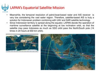
  • 12. LAPAN’s Equatorial Satellite Mission • Meanwhile, the temporal resolution of patrol-boat-based radar and AIS receiver is very low considering the vast water region. Therefore, satellite-based AIS is truly a solution for Indonesian problem combining with UAV and SAR satellite technology. • Since Indonesian territory is spread along the equator, LAPAN decide the operation of maritime surveillance satellite at the beginning at low inclination orbit, so that the satellite may pass Indonesia as much as SSO orbit pass the North/South pole (14 times in 24 hours at 650 km orbit).
  • 13. Space-borne AIS for Maritime Surveillance • AIS (Automatic Identification System) is a system that can monitor ships, based on GPS and VHF digital communication. It is regulated by IMO to be installed in ships weighing 300 tons and above. • By placing AIS receiver on the satellite, its coverage will be larger compared to the one usually placed on the seashore by maritime authority.
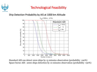
  • 14. Technological Feasibility The development of satellite-based AIS has been done since 2007 by the US military experimental satellite TACSAT-2. At the moment, commercial entities like Orbcomm, Com Dev, SpaceQuest dan Kongsberg Seatex has developed satellite AIS receiver. Plot of AIS Messages Collected by Nano-satellite Tracking of Ships (NTS) - Canada
  • 15. Standard AIS can detect 1000 ships by 15 minutes observation (probability >90%) Space-borne AIS : 2000 ships detection by 10 minutes observation (probability >90%) Standard AIS Technological Feasibility Ship Detection Probability by AIS at 1000 km Altitude
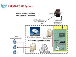
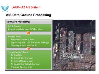
  • 17. Software Processing G/S Software: Acquisition Data from G/S Receiver Process Raw: • Remove Frame Counter • Separating AIS Data from Idle Package • Filtering AIS data with CRC Formatting AIS Data: • As Text File • As Shipplotter Format • As Ship NMEA Format • As Google Earth KML Format • Tracking Special Ship AIS Data Ground Processing LAPAN-A2 AIS System
  • 18. LAPAN-A2 satellite will be launched as auxiliary payload on PSLV mission at 2nd semester of 2015. LAPAN-A2 AIS System
  • 19. LAPAN-A3/IPB SATELLITE (An Experimental Remote Sensing Satellite) • Cooperate with Bogor Agricultural University (IPB) for payload specification • Orbit: ~650 km, 97,6 deg • Payload;  Experimental remote sensing, maritime monitoring, Science exp.  4 band pushbroom imager (450 - 520 nm; 520 - 600 nm; 630 690 nm; 760 - 900 nm), Hi res DigitalCam, AIS, APRS  ~18 m (~100 km swath) Multispectral/ ~4 m (~7 km) Matrix RGB  115 kg  End of 2015 • Weight: ~115 Kg
  • 20. Satellite Development Capabilities • In-house design capabilities • In-house Satellite Assembly, Integration & Test (AIT) with thermal, vacuum chamber, Uniform Light Source, 10,000 & 100,000 clean room class. • Customize Satellite operation software • Satellite Platform and structure manufacturing • TTC and image reception satellite operation • In-house satellite components development: (Reaction wheels, Magnetic coils, Star Tracker, On Board Data Handling) • Image systematic pre-processing, (Geometric, Radiometric correction, atmosferic refraction & dispersion, blurring distortion, stochastic distorsion)
  • 21. AERONAUTICS TECHNOLOGY DEVELOPMENT PROGRAM LAPAN SURVEILLANCE UAV (LSU)
  • 22. LSU Program Status AERONAUTICS TECHNOLOGY DEVELOPMENT PROGRAM (cont’d)
  • 23. VARIAN PROTOTYPE LSU LSU-01  Wing tail : 1900 mm  Lenght : 1200 mm  Take off : launch  Maximum Payload : 0,5 kg  Speed : 45 km/jam  Max speed : 60 km/jam  Airspeed Stall : 30 km/jam  Machine : Brushless  Fuel : Battery  Max flight time : 50 menit  Control System : Take off/landing by remote control & fly by autonomous LSU-02  Wing tail : 2400 mm  Lenght : 1700 mm  Maximum Payload : 3 kg  Speed : 100 km/jam  Max speed : 150 km/jam  Airspeed Stall : 40 km/jam  Machine : 2 Tax 32cc  Fuel : Pertamax plus & oli full sintetic  Tank : 3,5 liter  Max flight time : 3,8 jam  Control System : Take off/landing by remote control and fly by autonomous  LSU-03  Wing tail : 3500 mm  Lenght : 2500 mm  Tail Height : 700 mm  Center Wing : 900 mm  Speed : 100 km/jam  Max speed : 150 km/jam  Airspeed Stall : 60 km/jam  Maximum Payload : 10 kg  Machine : 2 Tax 100cc  Fuel : Pertamax Plus & Oli Full Sintetic  Tank : 7 liter  Max flight time : 5 jam  Control System : Take off/landing by remote control and fly by autonomous AERONAUTICS TECHNOLOGY DEVELOPMENT PROGRAM (cont’d)
  • 24. VARIAN PROTOTYPE LSU LSU-04  Wing tail : 4000 mm  Lenght : 3200 mm  MTOW : 65 kg  Speed : 100 km/jam  Max speed : 160 km/jam  Airspeed Stall : 60 km/jam  Maximum Payload : 18 kg  Machine : 11 HP  Tank : Pertamax plus &oli full sintetic  Tank : 8 liter  Max flight time : 6 jam  Control System: Take off/landing by remote control & flight by autonomous LSU-05  Wing tail : 5500 mm  Lenght : 4100 mm  Height : 1130 mm  MTOW : 77 kg  Empty Weight : 31 kg  Payload Mass : 30 kg  Fuel : 16 kg  Take Off Ground Round : 60 meter  Climb Rate : 600 ft/min  Range : 840 km  Endurance : 8 h  Lending Ground Run : 83 meter  Ceiling : 12000 ft  Cruise Altitude : 3000 ft  Cruise speed : 100km/h FADEX  Wing tail : 3500 mm  Lenght : 2800 mm  Take Off mass : 10 kg  Cruise Speed : 160 km/jam  Cruise Altitude : 1000 m  Max flight time : 0,5 jam  Proppeller : Turboshaft  Machine : 20 HP - 30 cc  Fuel : gasoline  Payload : 15 kg  Tank : 2 liter  Airframe : Composite  Control System: Take off/landing by remote control & flight by autonomous AERONAUTICS TECHNOLOGY DEVELOPMENT PROGRAM (cont’d)
  • 25. Program LSU progame achievement status LSU 02 in military 2012-2013 ( Ship On Board Take Off and Landing ) Battlefield maping, Dittop AD 1200 Ha (± 7 hours ) MURI record achievment (200 KM Autonumous) Flood monitoring REMOTE SENSING DATA AERONAUTICS TECHNOLOGY DEVELOPMENT PROGRAM (cont’d)
  • 26. LAPAN SURVEILLANCE AIRCRAFT (LSA) AERONAUTICS TECHNOLOGY DEVELOPMENT PROGRAM (cont’d)
  • 27. Status program LSA - AADP - UAV Research and Development of UAV :1 ton MTOW - Light and advanced Aircraft Research and Development ( Autonomous Control & Composite ) - Simulator System - Capacity Building (Master and Phd) AERONAUTICS TECHNOLOGY DEVELOPMENT PROGRAM (cont’d)
  • 28. LSA’s Program status Parameter Pengambilan Sample Lapangan Kondisi periode tanaman padi Biomas tanaman padi Tinggi tanaman padi Kerapatan tanaman Variabel fisik lainnya 0 SPESIFIKASI PESAWAT CESSNA 206  - Mesin : C o ntinental IO-520-A 285 hp  (213 kW)  - Tempat D u duk : one (crew) & five passengers  - Length : 8,61 m  - Wingspan : 10,97 m  - Height : 2,83 m  - Wing Area : 16,3 m2     - Airfoil : N A CA 2412  - Berat Ko song : 987 kg  - Max. Takeoff We i ght  : 1.632 kg  Performance  Kecepatan Maksimum  : 151 knots (280 km/h)   Kecepatan Cr uise : 142 knots (263 km/h)  Kecepatan Stall : 54 knots (100 km/h)  Jarak Tempuh : 840 mi (730 nmi, 1.352 km)  Serving ceiling : 15.700 ft (4.785 m) A Deskripsi LSA-S15 Pesawat terbang ringan Untuk melakukan misi  surveillance seperti pemetaan,         monitor-­ ing, SAR dan lain se bagainya. Pesawat ini  mempunyai  basic design berupa pesawat glider bermo-­ tor, Airframe pesawat terbuat dari  komposit dengan rangka utama  terbuat  dari  batang logam s i li nder. Memiliki desain modular airframe yang dapat memudahkan pesawat  diangkut dengan bagian ya ng terpisah-pisah. SPESIFIKASI PESAWAT STEMME S – 15  -Tipe  : Sayap Tetap, Retractable  Landing Gear  - Airframe : C a rbon Fiber & Glass Fiber C o mposites   - Mesin  : Tunggal – ROTAX 914 F2 (4 cylinder 4 stroke)  - Tempat D u duk : D u al (side by side)  -    Bahan Ba kar  : AVGAS UL  91 atau 110LL  - Jarak Tempuh : sampai dengan 604 nm/1119 km (75% power, 97 knot  - Durasi Terbang : sampai dengan 6 jam 13 menit (FF 20.4 ltr/jam)  - Service C e iling : Max 16.000 feet  - Panjang Landasan yang dibutuhkan          Take Off : Ground R o ll 425 m, 50ft obstacle 833m         Landing R o ll : (tidak disebut dlm POH, lebih pendek drpd T/O)         Gradient T/O : 591 ft/mnt – 3m/sec  - Maks B e rat :1100  kgs  - Payload : sampai dengan 148 kgs (1 pilot 70kg)  - Minimal Crew : 1 (satu) orang POD Kamera Kamera & Rangkaian Kamera Pemanfaatan : MAINTENANCE Parameter Pengambilan Sample Lapangan Kondisi periode tanaman padi Biomas tanaman padi Tinggi tanaman padi Kerapatan tanaman Variabel fisik lainnya 0  - Length : 8,61 m  - Wingspan : 10,97 m  - Height : 2,83 m  - Wing  Area : 16,3 m2      - Airfoil : N A CA 2412  - Berat Ko song : 987 kg  - Max. Takeoff We i ght  : 1.632 kg  Performance  Kecepatan Maksimum  : 151 knots (280 km/h)   Kecepatan Cr uise : 142 knots (263 km/h)  Kecepatan Stall : 54 knots (100  km/h)  Jarak  Tempuh : 840 mi (730 nmi, 1.352 km)  Serving ceiling : 15.700 ft (4.785 m) A Deskripsi LSA-S15 Pesawat terbang ringan Untuk melakukan misi  surveillance seperti pemetaan,         monitor-­ ing, SAR dan lain se bagainya. Pesawat ini  mempunyai  basic design berupa pesawat glider bermo-­ tor, Airframe pesawat terbuat dari  komposit dengan rangka utama terbuat  dari  batang logam s i li nder. Memiliki desain modular airframe yang dapat memudahkan pesawat  diangkut dengan  bagian ya ng terpisah-pisah.  - Mesin  : Tunggal – ROTAX 914  F2 (4 cylinder 4 stroke)  - Tempat D u duk : D u al (side by side)  -    Bahan Ba kar  : AVGAS UL  91 atau 110LL  - Jarak Tempuh : sampai dengan 604 nm/1119 km (75% power, 97 knot  - Durasi Terbang : sampai dengan 6 jam 13 menit (FF 20.4 ltr/jam)  - Service C e iling : Max 16.000 feet  - Panjang Landasan yang dibutuhkan          Take Off : Ground  R o ll 425 m, 50ft obstacle 833m         Landing R o ll : (tidak disebut dlm POH, lebih pendek drpd T/O)         Gradient T/O : 591 ft/mnt – 3m/sec  - Maks B e rat :1100 kgs  - Payload : sampai dengan 148 kgs (1 pilot 70kg)  - Minimal Crew : 1 (satu) orang POD Kamera Kamera & Rangkaian Kamera Pemanfaatan : MODIFICATION POD APPLICATION Stu dy Ar ea Subang – Indramayu, Jawa Barat • Lahan sawah : irigasi dan tadah hujan 11 Subang Jalur terbang LSA Titik pengamatan Indramayu Descending Ascending Akuisisi Radarsat APPLICATION TEST BBSDLP-PUSTEKDATA-PUSTEKBANG Cessna 2 0 6  PK-LPNLSA (LAPAN SU RVEILLANCE AIRCRAFT) SPESIFIKASI PESAWAT CESSNA 206  - Mesin : C o ntinental IO-520-A 285 hp (213 kW)  - Tempat D u duk : one (crew) & five passengers  - Length : 8,61 m  - Wingspan : 10,97 m  - Height : 2,83 m  - Wing Area : 16,3 m2      - Airfoil : N A CA 2412  - Berat Ko song : 987 kg  - Max. Takeoff We i ght  : 1.632 kg  Performance  Kecepatan Maksimum  : 151 knots (280 km/h)   Kecepatan Cr uise : 142 knots (263 km/h)  Kecepatan Stall : 54 knots  (100 km/h)  Jarak Tempuh : 840 mi (730 nmi, 1.352 km)  Serving ceiling : 15.700 ft (4.785 m) PUSTEKBANG L A PAN RU MPIN  Jl. R a ya L A PAN, S u k amulya Ru mpin—Bogor  Deskripsi LSA-S15 Pesawat terbang ringan Untuk melakukan misi  surveillance seperti pemetaan,         monitor-­ ing, SAR dan lain se bagainya. Pesawat ini  mempunyai  basic design berupa pesawat glider bermo-­ tor, Airframe pesawat terbuat dari  komposit dengan rangka utama terbuat  dari  batang logam s i li nder. SPESIFIKASI PESAWAT STEMME S – 15  -Tipe  : Sayap Tetap, Retractable Landing Gear  - Airframe : C a rbon Fiber & Glass Fiber C o mposites   - Mesin  : Tunggal – ROTAX 914 F2 (4 cylinder 4 stroke)  - Tempat D u duk : D u al (side by side)  -    Bahan Ba kar  : AVGAS UL  91 atau 110LL  - Jarak  Tempuh : sampai dengan 604 nm/1119 km (75% power, 97 knot  - Durasi Terbang : sampai dengan 6 jam 13 menit (FF 20.4 ltr/jam)  - Service C e iling : Max 16.000 feet  - Panjang  Landasan yang dibutuhkan          Take Off : Ground R o ll 425 m, 50ft obstacle 833m         Landing R o ll : (tidak disebut dlm POH, lebih pendek drpd T/O)         Gradient T/O : 591 ft/mnt – 3m/sec  - Maks B e rat :1100 kgs  - Payload : sampai dengan 148 kgs (1 pilot 70kg)  - Minimal Crew : 1 (satu) orang AERONAUTICS TECHNOLOGY DEVELOPMENT PROGRAM (cont’d)
  • 29. NATIONAL TRANSPORTATION AERONAUTICS TECHNOLOGY DEVELOPMENT PROGRAM (cont’d)
  • 30. Program Status of N-219 TRANSFER OF TECHNOLOGY 14 SPESIALIS WIND TUNNEL TEST PROCUREMENT (60-70%) & DETAIL DESIGN(90%) FIRST CUTTING DETAIL PART MANUFACTURING ROLL OUT 10 AGUSTUS 2015 FIRST FLIGHT DESEMBER 2015 AERONAUTICS TECHNOLOGY DEVELOPMENT PROGRAM (cont’d)
  • 31. LAPAN has been succesfully launched its rockets in Pameungpeuk Test Flight Station, Jawa Barat since 2008, RX- 320 on 2008, 19 May and RX-420 on 2009, 2 July. Moreover LAPAN were already testing on RX-550 mainly static test in 2011 and 2012. Further work LAPAN is going to retest RX 420. Meanwhile for RX-550, the bigest rocket developed by LAPAN wish make its flight test in 2015. • 2008 : RX-320 STATIC & FLIGHT TEST • 2009 : RX-420 STATIC & FLIGHT TEST • 2010 : RX-550 DESIGN • 2011 : RX-550 STATIC TEST • 2012 : RX-550 STATIC TEST • 2013 : RX-550 (SINGLE STAGE) FLIGHT TEST • 2014 : RX-550 (DOUBLE STAGES) FLIGHT TEST Currently status : LAPAN’s satellite launcher called Rocket Sonda designing and integrating autonomously. ROAD MAP OF ROCKET TECHNOLOGY PROGRAM
  • 32. Succesfully flown RSX 100 / RX 1210 RX 320 Succesfully flown Static test RX 450 Static test RCX 100H2 (liquid rocket) Space port In Morotai Island PROGRAM STATUS OF ROCKET TECHNOLOGY Succesfully flown RKX EDF / RKX TJ
  • 33. Informasi lahan sawah Kabupaten OKU Timur Several activities such as distribution of mid and high resolution data to user have been already done by Lapan to implementing the Inpres No. 6, 2012, about “Provision, Utilyzing, Quality Control, Proccesing and Distributing High Resolution Remote Sensing Data”. In oder to strengthen those activities, Lapan also has received and distributed LDCM/ Landsat-8’s data to user; ie. K/L, local government, TNI/Police, and private Mei 3, 2013,
  • 34. Strenghtening Facility Antena X-band 6.1 meter Antena X-band 5,4 meter Antena X-band 6.1 meter (Rumpin) Antena L-band 1,5 meter (Pekayon)
  • 36. Receiving, Processing and Management Remote Sensing Data System SPOT-5 /6 data receiving and processing systems Controlling room Antenna control system Receiving and Processing Data System In Balai Penginderaan Jauh Parepare Processing and management data system in Jakarta MODIS and NPP data processing systems Landsat data processing system Database Server
  • 37. Data Availability until 2014ata) Spatial Res Data Period Locations Low MTSAT-1R Okt 2008 – Now Indonesia Feng Yun-1D 2003 – 2011 Indonesia NOAA-18 2005 – Now Indonesia NOAA-19 2009 – sekarang Indonesia Terra/Aqua 2006 – sekarang Indonesia NPP Feb 2012 – sekarang Indonesia Mid ALOS AVNIR 2006 – 2011 Jawa, Sumatera, Bali, Nusa Tenggara, Kalimantan SPOT-2 Apr 2006 – Jun 2009 Indonesia SPOT-4 Apr 2006 – Jan 2013 Indonesia Landsat-5 1990 – 2009 Indonesia Landsat-7 2001 – sekarang Indonesia Landsat-8 Apr 2013 – sekarang Indonesia Rapid Eye 2012 -2013 Kalimantan, Jawa, Sumatera
  • 38. Data Availability (cont’d) Spatial Res Data Period Locations High SPOT-5 2005, Jan 2013 – now Sumatera, Jawa, Sulawesi, Nusa Tenggara, Kalimantan, Papua SPOT-6 Jan 2013 – now Sumatera, Jawa, Papua, Sulawesi, Kalimantan Pleiades Jun 2013 – now Province and cities in Indonesia ALOS Prism Jun 2006 – Oct 2009 Jawa, Sumatera, Bali, Nusa Tenggara, Kalimantan, Papua Ikonos 2000 – 2004, 2007, 2008, 2011 NAD, Papua, Jakarta, Jateng, Jatim, Papua Quickbird 2006 – 2010 Sumatera, Kalimantan, Papua, Jabar, Jatim World View 2010 – 2012 Maluku, Papua Geo Eye 2009 – 2011 Maluku, Papua, Jawa SAR TerraSAR-X 2010 – 2013 Jakarta, Riau, Jambi, Kalteng, Kaltim, Jateng, L. Timor, Nusa Tenggara ALOS Palsar 2006 – 2010 Kalimantan, Sumatera, Jawa Radarsat 2009 – 2010 Kalimantan
  • 39. SPOT-7SPOT-6 Landsat-9Landsat-8 (LDCM) Himawari-8Himawari-7 JPSS-1 MetOp-C NPP 2012 2013 2014 2015 2016 2017 2018 2019 2020 2021 2022 Terra Aqua NOAA-19 Himawari-6 SPOT-4 Landsat-7 SPOT-5 ALOS-2 SAOCOM-1A FY-3FFY-3EFY-3DFY-3CFY-3B Daily acquired Planed in 2012 Planed below 2013 Acquisition Planing (2012-2020)
  • 40. PROGRAM ACHIEVEMENT AND REMOTE SENSING ACTIVITY 1. Indonesia’s National Carbon Accounting System (INCAS) 2. Development of Remote sensing data bank, Bank Data Penginderaan Jauh Nasional (BDPJN)  UKP4 and BIG 3. Supporting; a. Maritim - ZPPI, coral reef, mangrove and mariculture b. Mitigation SPBK, hotspot, potentatial flooding, disater emergency respons, active vulcanos information. c. Natural Resources and environtment Paddy growth phase, rural areas, cloud 4. Academic advisor  mahasiswa ITS, IPB, UGM, UI, UNNES, UB, etc), Directing  Ditjenbun, BBSDLP, BPBD Kalbar, Dishut Riau, Ditjen PHKA, Kanwil Pajak Jateng, etc Servicing  KLH, BBSDLP, Dinas Perikanan, BPPT, Ditjen PHKA, UKP4, etc) Informasi Spasial Zona Potensi Penangkapan Ikan (ZPPI) Environment development and disaster mitigation Development model for Disaster mitigation of vulcano maping Forest land and Kalimantan island forest (2000-2009) Forest land and Sumatera island forest (2000-2009)
  • 41. 41 5. Contributing in Reducing Emissions from Deforestation and Forest Degradation (REDD+ Nasional), where LAPAN succesfully developed near real time information system for forest monitoring in order to fulfill UKP4 need; ie.. Daily Normalized Difference Vegetation Index (NDVI) daily and daily NDVI 16-daily including composite image. Terra/Aqua MODIS in 2009-2012 based on Google Earth. 6. International organizations, such as LandGate Australia, JAXA, ASEAN Secretariat, UN WFP, UN SPIDER, UN ESCAP, CARE International, GIC-AIT, ADRC, and WWF also use Remote sensing information to support disaster mitigation, and Sentinel data completed the aerial data and Carbon Accounting System. PROGRAM ACHIEVEMENT AND REMOTE SENSING ACTIVITY (cont’d)
  • 42. SPACE AND ATMOSPHERE SCIENCE Space Weather Monitoring Space Debris Communication Frequency Area Prediction Development of early warning systems and disaster mitigation base on satellite act an early warning system of rain fall (Sahadev version 2.0). Sadewa (Satellite Disaster Early Warning System) or Disaster early warning system base on MTSAT Space debris monitoring cooperate with BAPETEN for measuring the impact of space object radiation Dissemination of ionosphere information utilization for radio communications and Single Frequency of GPS measurement, have been widely used, especially by the military. R&D result of space weather monitoring is sosialized to related institutions such as :BMKG, PPGL, Basranas, Bappeten, Angkasa Pura, TNI AU, LPD Sumedang,BPD Pontianak, BPD Watukosek, BPPR Pameungpek, Dislitbang TNI – AU,Mahasiswa Politeknik Pos Indonesia, Universitas Telkom
  • 44. -Radio communication frequency monitoring inter locations (real time) -Ionosonda data real time Radio communication frequency prediction (monthly) Sintilasi appearance prediction(monthly)
  • 45. ASTINA : Is a multi-media display of an information system in the field of atmospheric science and technology which are constructed as a component of a decision support system to help users obtain information in accordance with the requirements as the basis for decision-making and policy-related sectors such as information services: weather, climate, agriculture, transportation, energy, environment, water resources, health, disaster management and education. ASTINA ROOM
  • 46. • Parameter information of Indonesia’s atmosphere based on Google Earth : MTSAT ir-1, Ch-TRRM, Ch prediction, resolution 5 km and 50 km 1. ARJUNA : AtmospheRic JoUrNey Arcade (Lorong Penjelajahan Atmosfer) Arjuna is a three-dimensional visual media where users can conduct exploration into the Earth's atmosphere to see the satellite-based observations, radar, airborne and in situ, as well as the prediction of atmospheric conditions short, medium and long-based dynamic models and statistical ASTINA ROOM COMPONENTS :
  • 47. National Space Development Master Plan • In the Space Laws No. 21/2013, it is mentioned that LAPAN should prepare a Master Plan for the implementation of national space guidelines. The master plan drawn up for a period of 25 (twenty five) years. Therefore, the current master plan is being drawn up, both academic and legal draft of President Regulation. The master plan has been proposed as one of national legislation program (prolegnas) in 2014. • The master plan will be prepared taking into account basic capabilities and the national and international strategic environment. The master plan contains the vision and mission, policies, strategies and short, medium, and long-term strategic plans.
  • 48. • The main issues in the master plan includes • the construction of national observatory to support space science; • to strengthen national remote sensing data bank; • to strengthen aeronautics technology for developing UAV (Unmanned Aerial Vehicle) and transport aircraft; • to develop national satellite for remote sensing, telecommunication, and navigation, starting from developing micro-satellite; • to develop rockets for satellite launching, starting from developing sounding rockets; • and to build aerospace port in Eastern Indonesia; • as well as to strengthen space policy studies. • To enhance public awareness, space science and technology education center should be built in locations of LAPAN’s station all over Indonesia. • The national aerospace master plan should be supported by preparing human resources and related industries. • National and international cooperation on space science, technology, and policy studies should be encouraged. National Space Development Master Plan

Editor's Notes

  • #10: Satelit SDA dan satelit komunikasi
  • #26: Rencana muri desember 2014 dgn LSU-03
  • #42: Informasi inderaja juga digunakan oleh organisasi internasional untuk berbagai keperluan, diantaranya oleh LandGate Australia, JAXA (Japan Aerospace and Exploration Agency), ASEAN Secretariat, UN WFP (United Nation World Food Program), UN SPIDER (United Nation Platform for Space Based Information for Disaster Emergency Response), UN ESCAP (United Nation for Economic and Social Committee for Asia and the Pacific), CARE International, GIC-AIT (Geo-informatics Center Asian Institute and Technology), ADRC (Asian Disaster Reduction Center), dan WWF (World Wide Fund). Mereka menggunakan data inderaja untuk mendukung informasi terkait mitigasi bencana, pembentukan sentinel Asia dalam rangka menghubungkan informasi kebencanaan dari data kedirgantaraan serta untuk keperluan Carbon Accounting System.
  • #44: According to space weather monitoring in Indonesia, now we have space weather observation networks. There are many observatories at Kototabang, Pontianak, Manado, Biak, Kupang, Watukosek, Pameungpeuk, Sumedang, and Bandung as the center. At Kototabang observatory we have fluxgate magnetometer, ionosonde, VHF radar, scintillation monitor, and also Automatic Link Establishment (ALE) to monitoring of HF radio propagation condition. At Pontianak observatory, we have similar equipments. They are magnetometer, ionosonde, TEC & scintillation monitor, MF-radar, and Automatic Link Establishment. The similar equipments, there are at Manado, Biak, Kupang, Watukosek, Pameungpeuk, Sumedang, and Bandung. Especialy, at Sumedang and Watukosek observatories, we have telescope and radio spectrograph for monitoring solar activities.