Gis for asset management
0 likes673 views

This document discusses using GIS solutions to track both movable and immovable assets. For movable assets like vehicles, GPS kits and online software are used to track location, speed, route, and other attributes. For immovable assets like heavy machinery, software like Leica Cyclone Geo-tagging tool can add geographic tags to identify asset locations. Virtual GIS allows 3D visualization of assets and terrain for analysis.


Gis for asset management
- 1. GIS for Asset Tracking & Management P CHANDRAMOULI M.Sc. SME for GIS solutions L&T TECHNOLOGY SERVICES LTD Hyderabad Chandramouli.peruri@gmail.com PH:9701234348
- 2. 2 Movable / Immovable Assets1 3 GIS Solutions for Immovable Assets 4 Virtual GIS GIS Solutions for Movable Assets
- 3. Movable And Immovable Assets Movable assets are those which are 'movable'- stocks, money, shares, furniture, gold, jewels, etc. Immovable are assets which cannot be moved- land and things fixed to the soil- trees, heavy machinery, etc
- 4. 2 Movable/Static Assets1 3 GIS Solutions for Immovable Assets 4 Virtual GIS GIS Solutions for Movable Assets
- 5. GIS Software Applications Viewing location spread of assets Query and retrieval of asset information U/s and D/s network trace of assets Field Force Automation using Profield Remote Sensing solutions for network planning applications Risk Analysis tools Mobile applications for asset data management
- 6. GIS solutions for Movable assets Movable assets are those which are 'movable'- furniture, gold, vehicles, etc
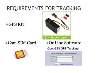
- 8. REQUIREMENTS FOR TRACKING GPS KIT Gsm SIM Card OnLine Software
- 9. STANDARD FEATURES Where is the Vehicle What is the velocity of Vehicle Does the Vehicle exceeds the speed limit Which route does the vehicle used
- 10. OPTIONAL FEATURES What is the temperature of Vehicle Which driver is driving the vehicle Which goods are loaded What is the fuel level Locking the Doors In Cabin Camera Stop the Engine
- 11. 2 Movable/Static Assets1 3 GIS Solutions for Movable Assets 4 Virtual GIS GIS Solutions for Immovable Assets
- 12. GIS solutions for Immovable assets Required software to identify the location of assets “Leica Cyclone Geo-tagging tool”
- 13. Adding Geo Tags Features and Benefits View TruView file sets locally or via the web Use high resolution images and true colour point clouds Full mark-up capabilities Within views, incorporate hyperlinks to asset information Include 3D models in TruView scenes
- 15. Specifications
- 16. 2 Movable/Static Assets1 3 GIS Solutions for Movable Assets 4 GIS Solutions for Immovable Assets Virtual GIS
- 17. Virtual GIS for Assets 3D visualisation Virtual GIS is a 3D visualisation and GIS module that offers fast and beautiful viewing, smooth moving and 3D analysis for everyone and superb stereo viewing . Its many options offer powerful possibilities.
- 18. 3D Virtual View