SlideShare a Scribd company logo
2
Most read
11
Most read
12
Most read
Latitude and Longitude
Latitude lines run east/west but they measure
north or south of the equator (0°) splitting the earth
into the Northern Hemisphere and Southern
Hemisphere.
Latitude
North Pole
South Pole
Lines of
latitude are
numbered
from 0° at
the equator
to 90° N.L.
at the North
Pole.
Lines of
latitude are
numbered
from 0° at
the equator
to 90° S.L.
at the
South Pole.
]
[
90 80
70
60
50
40
20
30
10
90
80
70
60
50
40
20
10
30
Latitude
The North Pole
is at 90° N
The South Pole
is at 90° S
The equator
is at 0°
latitude. It
is neither
north nor
south. It is
at the center
between
north and
south.
40° N is the 40°
line of latitude
north of the
equator.
40° S is the 40°
line of latitude
south of the
equator.
Longitude
Lines of longitude begin
at the Prime Meridian.
60° W is the
60° line of
longitude west
of the Prime
Meridian.
The Prime Meridian is located at 0°. It is
neither east or west
60° E is the
60° line of
longitude
east of the
Prime
Meridian.
W E
Longitude
Lines of longitude are numbered east from the
Prime Meridian to the 180° line and west from
the Prime Meridian to the 180° line.
PRIME MERIDIAN
WestLongitude
EastLongitude
180°
N
EW
S
North Pole
Prime Meridian
The Prime Meridian (0°) and the 180° line split the
earth into the Western Hemisphere and Eastern
Hemisphere.
Prime Meridian
Western
Hemisphere
Eastern
Hemisphere
Places located east of the Prime Meridian have an east
longitude (E) address. Places located west of the Prime
Meridian have a west longitude (W) address.
INTERNATIONAL DATE LINE
180°
• SEPARATES 2 CALENDAR DAYS.
America to Asia – gain a day
Asia to America – lose a day
By combining latitude and
longitude, any location can be
pinpointed
A location’s coordinates
(____° N or S, ____ ° E or W)
Application
N
W E
S
North America is in the Northern Hemisphere because it is
north of the Equator. North America is in the Western
Hemisphere because it is west of the Prime Meridian.
Fractions of a Degree
• 1 degree = 60 minutes or 1 minute is 1/60th
of a degree
• Use minutes if location is not directly on the latitude/longitude line
• Written ----- Degree/minute = XX° xx’ compass direction
30’ is half-way
between degrees
LONGITUDE AND TIME
• The world rotates (spins) 360° in 24 hours.
360° / 24 hours = 15° per hour
• The world has 24 time zones, each l5°
apart.
THERE IS A 1 HOUR TIME
DIFFERENCE FOR EVERY 15° OF
LONGITUDE
Greenwich, England is the logical
starting point for time zones
• The world rotates west to east
(counterclockwise), time zones to the east
are ahead of the those time zones to the
west
ANOTHER CHEESY SAYING
• EAST INCREASE
Time is forward to all places to the east
• WEST LESS
Time is backward to all places to the
west
East Increase – West Less
(1 hr per l5°)
If it 9 p.m. at Position D, what time is it at position C?
Position B?
If it is 1 p.m. at Position X, at which location is the time 5
Earth rotates west to east
Solar time is based on the position
of the sun
NIGHT IS FALLING ON EARTH
Look at the East Coast of the United
States. The lights are already lit.
California the sun is still visible.
This pictures shows
AMERICAN CITIES at
night.
Saguenay
Ottawa
Sept-Iles
Mexico
City
Québec
Montréal
St.John
Those light are Boston, New
York, Philadelphia and
Washington.
Toronto
Detroit
Miami
Havana
Puerto Rico
Houston
Dallas
It’s still daylight
in California
Thunder Bay
Port-au-Prince
NIGHT IS FALLING ON EARTH.
Look at Paris and Barcelona, the lights are
already lit, meanwhile in London, Lisbon and
Madrid the sun is still visible.
Looking south, we can see the islands in the
middle of the ocean.
We have a perfect view of the British Islands,
Iceland and Canada.
France
Spain
AFRICA
Italy
EnglandIceland
Atlantic
Ocean

More Related Content

PPTX
Geographic grid latitudes and longitudes made by Ravi Bharti
PPT
Leadership styles
PPTX
new 7 wonders of the world
PPTX
Prime Meridian,Equator, Latitude and longitude
PPSX
Lines of Latitude and Longitude – PowerPoint
PPT
Locating Places Using Coordinates.ppt
PPT
Geographic grid latitudes and longitudes made by Ravi Bharti
Leadership styles
new 7 wonders of the world
Prime Meridian,Equator, Latitude and longitude
Lines of Latitude and Longitude – PowerPoint
Locating Places Using Coordinates.ppt

What's hot (20)

PPTX
Latitude and longitude powerpoint
PPTX
PARALLELS AND MERIDIANS-FOR GRADE 5
PDF
Longitude time and ist 1
PPTX
Latitude and longitude
PDF
Latitude and Longitude
PPTX
Longitudes & latitudes
PPTX
Latitude and longitude
PPTX
Planet earth
PPT
Latitude and longitude 1
PPT
Class6 Earth Rotation And Revolution
PPTX
Globe: lattitudes and longitudes
PPTX
LANDFORMS in GEOGRAPHY
PDF
Chapter 3 rotation and revolution
PDF
Latitudes and longitudes
PPT
Elements of a map
PPT
Location and time
PPT
Maps And Globes Are Models Of The Earth
PPT
Finding Locations on Earth
PPT
Latitude And Longitude
PPTX
Introduction of Geography.pptx
Latitude and longitude powerpoint
PARALLELS AND MERIDIANS-FOR GRADE 5
Longitude time and ist 1
Latitude and longitude
Latitude and Longitude
Longitudes & latitudes
Latitude and longitude
Planet earth
Latitude and longitude 1
Class6 Earth Rotation And Revolution
Globe: lattitudes and longitudes
LANDFORMS in GEOGRAPHY
Chapter 3 rotation and revolution
Latitudes and longitudes
Elements of a map
Location and time
Maps And Globes Are Models Of The Earth
Finding Locations on Earth
Latitude And Longitude
Introduction of Geography.pptx
Ad

Viewers also liked (20)

PPT
Safety mooring
PPTX
Teaching syllabus
PDF
Interview Questions
PDF
Hacking an Interview using Public Speaking Tips
PPTX
Charts
PPS
Berthing etc-test 1
PPTX
Warning signs копия
PDF
Presentation - Global Presentation - Services & Products
PPT
Code of safe_practice
DOCX
DOCX
Container Securing System for ships
PPTX
Bridge Navigational Watch Alarm System
PPT
Copy of radionavigation radar
PPT
Bridge management lrg
PDF
Gmdss guide
PPT
Bridge resources management lrg
PPT
ROR review
PDF
MANEUVERING & COLLISION AVOIDANCE
PPTX
Types of containers
PPS
Colreg shape animation
Safety mooring
Teaching syllabus
Interview Questions
Hacking an Interview using Public Speaking Tips
Charts
Berthing etc-test 1
Warning signs копия
Presentation - Global Presentation - Services & Products
Code of safe_practice
Container Securing System for ships
Bridge Navigational Watch Alarm System
Copy of radionavigation radar
Bridge management lrg
Gmdss guide
Bridge resources management lrg
ROR review
MANEUVERING & COLLISION AVOIDANCE
Types of containers
Colreg shape animation
Ad

Similar to Latitude and Longitude (20)

PPTX
India size and location
PPT
Latitude and longitude
PDF
Intro to Navigation
PDF
GLOBE.pdf
PPTX
3 lengte en breetelyne
PPT
Latitude and Longitude 7.ppt (essential for Science
PPT
LLLLLLLLLLLLLOCATING PLACES ON EARTH.ppt
PPT
Latitude & Longitude
PPTX
_L-14 The Globe- Latitudes and Longitudes new.pptx
PPT
lat_and_lon_poewrpoint1_teacher_copy.ppt
PDF
Ppt of Class 6 ,ch 2, globe , Geography pdf
PPTX
4 atlas en kaartskale
PPT
Geography five lab one
PPTX
location of places.pptx
PPTX
Latitudes and Longitudes [Autosaved].pptx
PPTX
Satellite Communication Lec4, Chat Rooms GupshupCorner.com Pakistan.
PPTX
LONGITUDE AND LATITUDE
PPT
Geography five lab one
PPT
understanding longitude and latitude present
PPT
Time Presentation
India size and location
Latitude and longitude
Intro to Navigation
GLOBE.pdf
3 lengte en breetelyne
Latitude and Longitude 7.ppt (essential for Science
LLLLLLLLLLLLLOCATING PLACES ON EARTH.ppt
Latitude & Longitude
_L-14 The Globe- Latitudes and Longitudes new.pptx
lat_and_lon_poewrpoint1_teacher_copy.ppt
Ppt of Class 6 ,ch 2, globe , Geography pdf
4 atlas en kaartskale
Geography five lab one
location of places.pptx
Latitudes and Longitudes [Autosaved].pptx
Satellite Communication Lec4, Chat Rooms GupshupCorner.com Pakistan.
LONGITUDE AND LATITUDE
Geography five lab one
understanding longitude and latitude present
Time Presentation

More from kov083 (10)

PPT
Syllabus
PPT
Jeopardy 2017
PPT
Geography
PPS
Syllabus
PPTX
Syllabus
PPTX
презентация ия
PPTX
Pilotage 2
PPTX
Презентація курсу "Іноземна мова"
PPS
Berthing and Anchoring
PPTX
Types of anchorage
Syllabus
Jeopardy 2017
Geography
Syllabus
Syllabus
презентация ия
Pilotage 2
Презентація курсу "Іноземна мова"
Berthing and Anchoring
Types of anchorage

Recently uploaded (20)

PDF
O5-L3 Freight Transport Ops (International) V1.pdf
PDF
01-Introduction-to-Information-Management.pdf
PDF
2.FourierTransform-ShortQuestionswithAnswers.pdf
PDF
Origin of periodic table-Mendeleev’s Periodic-Modern Periodic table
PDF
STATICS OF THE RIGID BODIES Hibbelers.pdf
PPTX
Renaissance Architecture: A Journey from Faith to Humanism
PDF
Chapter 2 Heredity, Prenatal Development, and Birth.pdf
PDF
102 student loan defaulters named and shamed – Is someone you know on the list?
PDF
Saundersa Comprehensive Review for the NCLEX-RN Examination.pdf
PDF
Supply Chain Operations Speaking Notes -ICLT Program
PDF
grade 11-chemistry_fetena_net_5883.pdf teacher guide for all student
PPTX
IMMUNITY IMMUNITY refers to protection against infection, and the immune syst...
PPTX
Cell Structure & Organelles in detailed.
PDF
Module 4: Burden of Disease Tutorial Slides S2 2025
PDF
3rd Neelam Sanjeevareddy Memorial Lecture.pdf
PDF
VCE English Exam - Section C Student Revision Booklet
PPTX
school management -TNTEU- B.Ed., Semester II Unit 1.pptx
PDF
Basic Mud Logging Guide for educational purpose
PPTX
Pharmacology of Heart Failure /Pharmacotherapy of CHF
PPTX
BOWEL ELIMINATION FACTORS AFFECTING AND TYPES
O5-L3 Freight Transport Ops (International) V1.pdf
01-Introduction-to-Information-Management.pdf
2.FourierTransform-ShortQuestionswithAnswers.pdf
Origin of periodic table-Mendeleev’s Periodic-Modern Periodic table
STATICS OF THE RIGID BODIES Hibbelers.pdf
Renaissance Architecture: A Journey from Faith to Humanism
Chapter 2 Heredity, Prenatal Development, and Birth.pdf
102 student loan defaulters named and shamed – Is someone you know on the list?
Saundersa Comprehensive Review for the NCLEX-RN Examination.pdf
Supply Chain Operations Speaking Notes -ICLT Program
grade 11-chemistry_fetena_net_5883.pdf teacher guide for all student
IMMUNITY IMMUNITY refers to protection against infection, and the immune syst...
Cell Structure & Organelles in detailed.
Module 4: Burden of Disease Tutorial Slides S2 2025
3rd Neelam Sanjeevareddy Memorial Lecture.pdf
VCE English Exam - Section C Student Revision Booklet
school management -TNTEU- B.Ed., Semester II Unit 1.pptx
Basic Mud Logging Guide for educational purpose
Pharmacology of Heart Failure /Pharmacotherapy of CHF
BOWEL ELIMINATION FACTORS AFFECTING AND TYPES

Latitude and Longitude

  • 2. Latitude lines run east/west but they measure north or south of the equator (0°) splitting the earth into the Northern Hemisphere and Southern Hemisphere.
  • 3. Latitude North Pole South Pole Lines of latitude are numbered from 0° at the equator to 90° N.L. at the North Pole. Lines of latitude are numbered from 0° at the equator to 90° S.L. at the South Pole. ] [ 90 80 70 60 50 40 20 30 10 90 80 70 60 50 40 20 10 30
  • 4. Latitude The North Pole is at 90° N The South Pole is at 90° S The equator is at 0° latitude. It is neither north nor south. It is at the center between north and south. 40° N is the 40° line of latitude north of the equator. 40° S is the 40° line of latitude south of the equator.
  • 5. Longitude Lines of longitude begin at the Prime Meridian. 60° W is the 60° line of longitude west of the Prime Meridian. The Prime Meridian is located at 0°. It is neither east or west 60° E is the 60° line of longitude east of the Prime Meridian. W E
  • 6. Longitude Lines of longitude are numbered east from the Prime Meridian to the 180° line and west from the Prime Meridian to the 180° line. PRIME MERIDIAN WestLongitude EastLongitude 180° N EW S North Pole
  • 7. Prime Meridian The Prime Meridian (0°) and the 180° line split the earth into the Western Hemisphere and Eastern Hemisphere. Prime Meridian Western Hemisphere Eastern Hemisphere Places located east of the Prime Meridian have an east longitude (E) address. Places located west of the Prime Meridian have a west longitude (W) address.
  • 8. INTERNATIONAL DATE LINE 180° • SEPARATES 2 CALENDAR DAYS. America to Asia – gain a day Asia to America – lose a day
  • 9. By combining latitude and longitude, any location can be pinpointed
  • 10. A location’s coordinates (____° N or S, ____ ° E or W)
  • 11. Application N W E S North America is in the Northern Hemisphere because it is north of the Equator. North America is in the Western Hemisphere because it is west of the Prime Meridian.
  • 12. Fractions of a Degree • 1 degree = 60 minutes or 1 minute is 1/60th of a degree • Use minutes if location is not directly on the latitude/longitude line • Written ----- Degree/minute = XX° xx’ compass direction 30’ is half-way between degrees
  • 13. LONGITUDE AND TIME • The world rotates (spins) 360° in 24 hours. 360° / 24 hours = 15° per hour • The world has 24 time zones, each l5° apart. THERE IS A 1 HOUR TIME DIFFERENCE FOR EVERY 15° OF LONGITUDE
  • 14. Greenwich, England is the logical starting point for time zones • The world rotates west to east (counterclockwise), time zones to the east are ahead of the those time zones to the west
  • 15. ANOTHER CHEESY SAYING • EAST INCREASE Time is forward to all places to the east • WEST LESS Time is backward to all places to the west
  • 16. East Increase – West Less (1 hr per l5°) If it 9 p.m. at Position D, what time is it at position C? Position B? If it is 1 p.m. at Position X, at which location is the time 5
  • 17. Earth rotates west to east Solar time is based on the position of the sun NIGHT IS FALLING ON EARTH Look at the East Coast of the United States. The lights are already lit. California the sun is still visible.
  • 18. This pictures shows AMERICAN CITIES at night.
  • 19. Saguenay Ottawa Sept-Iles Mexico City Québec Montréal St.John Those light are Boston, New York, Philadelphia and Washington. Toronto Detroit Miami Havana Puerto Rico Houston Dallas It’s still daylight in California Thunder Bay Port-au-Prince
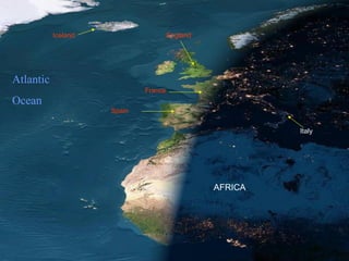
  • 20. NIGHT IS FALLING ON EARTH. Look at Paris and Barcelona, the lights are already lit, meanwhile in London, Lisbon and Madrid the sun is still visible. Looking south, we can see the islands in the middle of the ocean. We have a perfect view of the British Islands, Iceland and Canada.

Editor's Notes

  • #4: TEKS: Social Studies – 6.22 (A), Using social studies terminology correctly 7.22 (A), 8.31 (A)
  • #5: TEKS: Social Studies – 6.22 (A), Using social studies terminology correctly 7.22 (A), 8.31 (A)
  • #6: TEKS: Social Studies – 6.22 (A), Using social studies terminology correctly 7.22 (A), 8.31 (A)
  • #7: TEKS: Social Studies – 6.22 (A), Using social studies terminology correctly 7.22 (A), 8.31 (A)
  • #8: TEKS: Social Studies – 6.22 (A), Using social studies terminology correctly 7.22 (A), 8.31 (A)
  • #9: If you took a cruise on a ship, circumventing, or traveling around the entire planet, you would experience firsthand a phenomena that would help you understand the importance of an international dateline. An explorer by the name of Ferdinand Magellan did just that in the year 1519. Magellan along with 241 men set out to travel around the entire Earth. These men kept very careful records as they traveled. Yet, when they returned, they found that their calendars were off by one day with the calendars of everyone in their home countries. What happened? How did these men loose an entire day? The day was not lost all at once. It was lost little by little, as the traveled around the Earth. If you stay in one place, a day lasts 24 hours. However, if you travel the opposite direction of the rotation of the Earth, your day will be slightly longer than 24 hours, because you are traveling ahead of the setting sun. If you travel with the rotation of the Earth, your day will be slightly shorter than 24 hours, because you are traveling into the sunset. At any one moment there are actually two days on the Earth at the same time. A new day begins at mid-night on the International Dateline. It travels around the Earth, until 48 hours later it ends back at the International dateline. If you were to travel across the International Dateline, the date would change either forward, or backward. This line actually lies in the middle of a time zone. This means that the hour on the clock would not change, as you crossed over, just the date.
  • #12: TEKS: Social Studies – 6.3 (B), Posing and answering questions about geographic distributions and patterns 6.22 (A), Using social studies terminology correctly 7.22 (A), 8.31 (A)