


Lecture_1_Satellite Basics.pdfAAAAAAAAAAA
- 1. Satellite Communication System Dr. Rashed Md. Murad Hasan 2025 1
- 2. Outline • Introduction • Concept and Basic of Satellite Communication • Factors in satellite communication • Orbits and Related Issues 2
- 3. Need of space communication 3
- 4. How many towers required to cover Bangladeshi land mass? ❑ Assume- ▪ Bangladesh land area = 148460 Km2 ▪ Mobile tower cover a radius of 1 Km ▪ All towers are interconnected to provide all Bangladesh coverage ▪ Calculate number of mobile towers required to fully cover Bangladesh ❑Calculation: ▪ Mobile tower coverage with 1Km radius = 3.14 Km2 ▪ Number of towers = 148460/3.14 = 47280 4
- 7. Satellite Communication ❑ What is the satellite communications? ▪ Satellite communication is the communication between two or more earth stations (user terminals) by using artificial earth satellites as relay stations to forward radio waves. ❑Satellite communication has three forms: ▪ Between satellite and earth station; ▪ Between satellites; ▪ Between earth stations via satellites. 7
- 8. Features ▪ Launch and control technology is complex ▪ Propagation delay is large ▪ Affected by outer space ▪ Communication distance is long ▪ Service scope is wide ▪ Communication quality is good ▪ Not restricted by geographical conditions ▪ Wide available bandwidth ▪ Large communication capacity ▪ Independent of the ground communication ▪ Network routing is simple. ▪ Network construction is fast and low cost. ▪ Secure communication. ▪ Communication costs are independent of communication distance. 8
- 9. Early Idea ❑ The idea of satellite communications was first proposed by British Air Force officer Arthur C. Clarke (science fiction writer) in the “Wireless World" magazine "Extra-Terrestrial Relays" (1945). 9
- 10. Early Idea Use of three satellites in geosynchronous orbit to enable international coverage. 10
- 11. v.s. Cell ❑ More than 80% of the land and more than 95% of the sea area in the world lack effective broadband information coverage. ❑ Problems of terrestrial networks: ▪ Cells: constantly split, base station configuration problem ▪ Expensive infrastructure investment in low population density areas ▪ Limited communication in the air, ocean and special occasions ▪ multi-hop network, high complexity, service quality cannot be guaranteed ❑ Advantages of satellite communications ▪ Broadcast to very large area ▪ Reliable solution to last mile problem ▪ Quick set up time with Bandwidth on demand ▪ Provide fairness of service as demanded ▪ Long life 11
- 15. INMARSAT - 4 15
- 17. Thuraiya 17
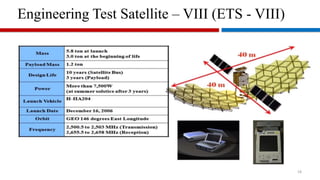
- 18. Engineering Test Satellite – VIII (ETS - VIII) 18
- 19. 19
- 20. 20
- 21. Bangladesh – First Satellite 21
- 22. Orbits 22 Typical orbit raising mission
- 23. Orbits 23 Johannes Kepler 1571 - 1630 Laws of Planetary motion The planets orbit in elliptical path with sun at focus Same is true for the satellite around earth The line joining a planet to sun sweeps out equal space in equal time Velocity of satellite is slower at apogee and faster at perigee
- 24. Orbits 24 Third Law of Planetary motion ‘The square of the period of a planet to the orbit is proportional to the cube of mean distance from the sun’ Derivation for a circular orbit Centripetal Force = Centrifugal Force m = mass of the body in Kg v = velocity of the body in Km/s r = radius of circle in Km a = acceleration in Km/s2 F = ma Newton
- 25. Orbits 25 Third Law of Planetary motion - for a circular orbit
- 26. Orbits 26 Third Law of Planetary motion - for a elliptical orbit Circle is a special form of ellipse
- 27. Orbits 27 Third Law of Planetary motion - for an elliptical orbit
- 28. Orbits 28 For continuous visibility – Either put a constellation of satellites at lower earth Orbit Or make it relatively stable with respect to earth If satellite period is made same as that of earth revolution around its own axis, Satellite apparently remains stable with respect to an observer on earth
- 29. Orbits – What is a Day? 29
- 30. Orbits 30 Assuming spherical earth with radius of 6378 Km Orbital height = 42164 – 6378 = 35786 Km At these height the satellite is moving in synchronism with earth rotation when it moves in the same direction as the earth revolves (west to East). It is called Geo Synchronous Orbit or GSO. What is the orbital height of a circular orbit satellite with a period of one sidereal day?
- 31. When this orbital plane is same as equatorial plane then for observer on earth surface the satellite seems to be at a stationery point above the equator. Orbits 31 Then it is called a Geostationary Orbit or GEO.
- 32. A geostationary orbit satellite will have - satellite moves in the same direction as the earth revolves - Orbital period is one sidereal day - It should be in circular orbit, and - Orbital plane have 0 angles with equatorial plane. Bangabandhu Satellite-I (BS-I) is placed in GEO. Orbits 32
- 33. Satellite locations are referred with subsatellite point ( lat, long). Orbits 33 Satellite Locations Bangabandhu Satellite-I (BS-I) is at 119.1E. Sub satellite point of BS-I is on equator at 119.1E longitude.
- 34. Orbits ❑ GEO (geostationary earth orbit) ▪ Height: 36,000 km ▪ Orbital period: 24 hours. ▪ Propagation delay: 250ms. ▪ The coverage area is stable. ❑ LEO (low earth orbit) ▪ Height: 500~1,500km ▪ Orbital period: 1.5~2 hours ▪ Propagation delay: < 10ms ▪ Doppler effect ▪ Maximum visible time: 20 minutes. ▪ Signal propagation distance: short ▪ Link loss: small ▪ Transmission power: low ❑ MEO (medium earth orbit) ▪ Height: 5000km~20000km ▪ Orbital period: 5-10 hours ▪ Propagation delay: 50ms. ▪ Maximum visible time: a few hours. 34
- 35. Orbits 35 Elevation: Angle between local horizontal plane to satellite. Azimuth: Angle from north to the line joining the point created by satellite to earth-center line on the horizontal plane with east wise movement. Antenna has been pointed skyward in angle of elevation and from the north eastward on the horizontal plane in angle of azimuth. Elevation and Azimuth
- 36. Orbits 36 Range and Look angle
- 37. Orbits 37 Range and Look angle
- 38. Orbits 38 Range and Look angle
- 39. Orbits 39 Range and Look angle Using spherical triangles and law of cosine: For GEO, LS is zero:
- 40. Orbits 40 Elevation angle BS-1 at 119.1E, 0N at Gazipur (90.4E, 24N). Find earth station elevation angle to BS-1. Le = 24 Ls = 0 le = 90.4 ls = 119.1 36.740 = 0.80 For 36.74, re = 6378 Km, rs = 42164 Km, El = ?
- 41. Orbits 41 Azimuth angle Azimuth angle is found through an intermediate angle α. Azimuth angle should be found from the following table: ES at Northern Hemisphere ES at Southern Hemisphere SSP East of ES 180 - α SSP East of ES α SSP West of ES 180 + α SSP West of ES 360 - α
- 43. Orbits 43 Satellite visibility For a satellite to be visible, For a GEO satellite, Length of coverage on earth surface, EZ = 2β =
- 44. Orbits 44 Satellite visibility Earth station at equator can see satellite within an arc of ± 81.3 from its longitude. What is the GSO visibility arc for an earth station located at 87E? 87 – 81.3 = 5.7 E 87 + 81.3 = 168.3 E
- 45. Orbits 45 Satellite visibility To cover whole earth with at least one satellite visibility any time in the orbital plane. Number of satellites in the constellation ≥ 360 ∕ 2γ
- 46. Orbits ❑ Track height selection ▪ Van Allen belt: A harsh electric radiation environment, strong electromagnetic radiation. α particles, protons and high energy particles are destructive to the circuit. ➢ Inner layer: 1,500-5,000 km ➢ Outer layer: 13,000-20,000 km ▪ Atmospheric resistance on satellite motion: altitude < 700 km. ▪ Three suitable windows: 700~1,500km; 5,000~Near 13,000km; more than 20,000 km. ❑ Factors to select the track ▪ Height: Higher the satellite -> Larger the coverage area -> Greater the fading ▪ Elevation angle: Angle between the earth station antenna and the ground plane: 0 ~ 70 degree. ▪ Propagation time: Propagation distance / speed of light. ▪ Interference: Same and adjacent channel interference. ▪ Launch vehicle performance: Rocket technology and reliability. 46
- 47. 47 THANK YOU © EEE, CUET