Remote Sensing and GIS Applications
Download as PPTX, PDF0 likes241 views

The document discusses remote sensing and GIS applications, highlighting the differences between multispectral and hyperspectral imagery, including their respective band selections. It covers various Landsat 8 bands and includes information on data levels, remote sensing resolution, and aerosol optical depth measurements. Key resources and links related to remote sensing applications are also provided.


Remote Sensing and GIS Applications
- 1. Remote Sensing & GIS Applications Lokhaze Ali PhD Student Environmental Engineering (NUST)
- 4. Multispectral vs Hyperspectral Bands • Multispectral imagery generally refers to 3 to 10 bands that are represented in pixels • Hyperspectral imagery consists of much narrower bands (10-20 nm) • Hyperspectral image could have hundreds of thousands of bands • This uses an imaging spectrometer • The main difference between multispectral and hyperspectral is the number of bands and how narrow the bands are RemoteSensing&GISApplications 4
- 5. Multispectral Bands in Landsat 8 Band 1: Coastal aerosol (0.43-0.45 um) Band 2: Blue (0.45-0.51 um) Band 3: Green (0.53-0.59 um) Band 4: Red (0.64-0.67 um) Band 5: Near infrared NIR (0.85-0.88 um) Band 6: Short-wave Infrared SWIR 1 (1.57-1.65 um) Band 7: Short-wave Infrared SWIR 2 (2.11-2.29 um) Band 8: Panchromatic (0.50-0.68 um) Band 9: Cirrus (1.36-1.38 um) Band 10: Thermal Infrared TIRS 1 (10.60-11.19 um) Band 11: Thermal Infrared TIRS 2 (11.50-12.51 um) RemoteSensing&GISApplications 5
- 6. 3D Cube of Farmland • 320 X 320 Pixels Farmland Area • 193 Spectral Bands RemoteSensing&GISApplications 6
- 7. Levels of Data Level 1B Level 2 Level 3 Calibration to Radiance Aerosol Retrieval Algorithm Spatial & Temporal Averaging Ref: Dr. Pawan Gupta (NASA), 2015 RemoteSensing&GISApplications 7
- 8. Cyclone Chapala 3rd November 2015 RemoteSensing&GISApplications 8
- 9. Cyclone Megh 9th November 2015 RemoteSensing&GISApplications 9
- 11. MODIS Real Time Image RemoteSensing&GISApplications 11
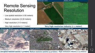
- 12. Remote Sensing Resolution • Low spatial resolution (>30 meters) • Medium resolution (5-30 meters) • High resolution (1-5 meters) • Very high resolution (< 1 meter) RemoteSensing&GISApplications 12
- 14. Comparison of Top of Atmosphere and Surface Reflectance RemoteSensing&GISApplications 14
- 15. Aerosol Optical Depth (AOD) Aerosol optical depth is quantitative measure of the extinction of the solar radiation by aerosol scattering between the point of observation and the top of the atmosphere 15 #Aerosols
- 16. MODIS Monthly AOD Results 2015 over Pakistan RemoteSensing&GISApplications 16
- 17. MODIS Monthly AOD Results 2014 over Pakistan RemoteSensing&GISApplications 17
- 18. MODIS Monthly AOD Results 2013 over Pakistan RemoteSensing&GISApplications 18
- 19. Important Links • EOSDIS Worldview https://earthdata.nasa.gov/labs/worldview/ • Pakistan Meteorological Department Precipitation Model http://www.pmd.gov.pk/loop.htm • Landsat Gallery http://landsat.usgs.gov/gallery.php • Digital Globe http://global.digitalglobe.com/sites/default/files/DG-RemoteSensing-WP.pdf • Cyclone Chapala http://earthobservatory.nasa.gov/IOTD/view.php?id=86951&src=fb RemoteSensing&GISApplications 19