


![Jacques Cousteau
(1910-1997)
Most famous oceanographer of the
20th century
If we go on the way
we have, the fault is
our greed... if we are
not willing [to
change], we will
disappear from the
face of the globe, to
be replaced by the
insect.
~ Jacques Cousteau
](https://image.slidesharecdn.com/serc1introd-ocean-191205053056/85/Serc-1-introd-ocean-13-320.jpg)


Serc 1 introd ocean
- 2. DR. A.S.N.MURTY PROFESSOR DEPARTMFENT OF METEOROLOGY & HYDROLOGY ARBAMINCH UNIVERSITY
- 4. Why did Benjamin Franklin make his map? First Postmaster General of U.S., he wanted to speed the mails across the Atlantic. Benjamin Franklin – 1700’s – Published map of Gulf Stream based on fishermen’s and merchants’ experiences “You may delay but time will not.” Benjamin Franklin
- 5. Benjamin Franklin’s Gulf Stream Map
- 6. Benjamin Franklin’s map and satellite photo of Gulf Stream “You may delay but time will not wait.” Benjamin Franklin
- 7. The Challenger Expedition (1872-76) Comprehensive scientific expedition Naval corvette fitted with laboratories, winches, and sounding facility and headed by C.Wyville Thompson Circumnavigated whole of the world 361 sounding stations covered Collected large number of deep-sea water samples Investigated deep-water motion Temperature measurements made at all depths Thousands of biological and sea-bottom sediment samples were collected 4717 new species were identified The analyses of samples collected took several decades Mariana’s trench depth was measured first time
- 8. Voyage of the Challenger, 1872-1876
- 9. Challenger’s expedition- The first global oceanographic cruise for scientific study was made by the British ship, the HMS Challenger during (1872-1876).
- 11. Whole of Atlantic ocean first time scientifically studied by Meteor expedition(1925-27)
- 13. Jacques Cousteau (1910-1997) Most famous oceanographer of the 20th century If we go on the way we have, the fault is our greed... if we are not willing [to change], we will disappear from the face of the globe, to be replaced by the insect. ~ Jacques Cousteau
- 14. Submersibles- ALVIN & BATHYSCAPE were made by Woods Hole Oceanographic Institution and can carry 3 passengers to depths up to 4500m (14,764 ft.), to explore the ocean, to see the marine environment physically and record data. Jacques Cousteau- Inventor of Aqualung- today’s SCUBA; he was a champion to see the pollution physically in the deep oceans—and worried about the man’s exploitation of the earth- as the destroyer of the marine environment.
- 15. Can you say what it is? The picture below is a _____________.submersible
- 16. Bathyscaphe -Trieste (the most advanced submersible of 20th century)
- 17. A technological revolution in today’s Oceanographic studies. Scripps Institution of Oceanography developed FLIP (Floating Instrumentation Platform)- a boat that turns vertically for research at different depths and can go horizontally like a ship Today’s Oceanography- FLIP Can you believe when FLIP is in its vertical position it is extremely stable even under high storm waves!!. It is used to study the way water circulates, how storm waves are formed, how heat is exchanged between the ocean and the atmosphere, and the sound made by underwater marine animals etc.
- 18. The Glomar Challenger Deep Sea Drilling Project Ship (1968 to 1983) It has a huge derrick that can reach a previous pin hole made at the sea bottom at any time and is governed by SATNAV
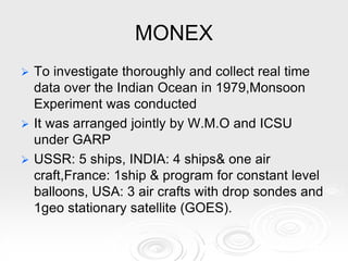
- 19. MONEX To investigate thoroughly and collect real time data over the Indian Ocean in 1979,Monsoon Experiment was conducted It was arranged jointly by W.M.O and ICSU under GARP USSR: 5 ships, INDIA: 4 ships& one air craft,France: 1ship & program for constant level balloons, USA: 3 air crafts with drop sondes and 1geo stationary satellite (GOES).
- 20. See the area influenced by Monsoon-obtained from Monex
- 21. Results of monsoon- See how monsoon winds are blowing These winds were derived by cloud vectors with the help of INSAT- 1 on 5.7.1979 at 600m level at 10 A.M
- 22. Automatic weather station in Dakshina Gangotri (Antarctica)
- 24. Compare the thickness of ocean with earth’s interior
- 25. 70.8% of the Earth is covered by ocean Oceans contain 97.2% of water on the surface of the earth
- 26. Major Oceans The three major oceans are : 1._______the largest, deepest, coldest and the least salty. 2.__________the second largest, shallow, warm and salty. 3. _________ intermediate in depth, temperature and salinity. The _______Ocean near the north pole, and the ____________ Ocean near the south pole contain vast expanses of sea ice. Pacific Atlantic Indian Arctic Antarctic
- 27. Name Area Avg. Depth 10 6 Km2. m. Pacific Ocean 165.2 4282 Atlantic Ocean 82.4 3926 Indian Ocean 73.4 3963 Southern Ocean 32.0 3930 Arctic Ocean 14.0 1205 Greatest Known Depth m. Name of Region 11,524 Mariana Trench 9074 Puerto Rico Trench 7338 Sunda Trench 6820 South Sandwich Trench 5536 N/A
- 28. Pacific Ocean: 181,34 x 10⁶ km2 Hmed = 4270 m Lmax = 19800 km N:Bering Sea& Gulf of Alaska S: Antárctica W: 147E meridion of Tasmania E: 1000E merdion of west coast of N & S America
- 29. The ocean's name, derived from Greek mythology, means the “Sea of Atlas." It is the most saline of all the major oceans; the salinity at the surface in the open ocean ranges from 33 to 37‰ or (3.3 - 3.7%) Endangered marine species are the manatee, and the seal (sea lion)in this ocean. The Atlantic Ocean is the second- largest ocean, covering about 1/5 of the Earth's surface.
- 30. Oceano Atlântico (OA): 106,57 x 10⁶ km2 Hmed = 3332 m 2848 km < L < 4830 km N-S: regions of Antártica and Árctica E: Cape of Good Hope (20E) W: Cape Horn
- 31. The Indian Ocean is the third largest body of water in the world, covering about 20% of the Earth's water surface. The climate north of the equator is affected by monsoon wind systems causing rainy seasons that last for 4 months at a time. The Indian Ocean was the sight of the underwater earthquake that caused the devastating Asian Tsunami of 26 Dec 2004.
- 32. Indian Ocean: Area: 74,12 x 10⁶ km2 Hmean = 3890 m Lmax = 10000 km N-S: Antártica to of Asiá E-W: East Africa to West Australia
- 33. It is the world’s fourth largest ocean and the least and latest to be studied. It encircles Antarctica, the highest continent in the world. May be the site of large oil and gas fields near the ocean and continental margin. Its northernmost boundary is defined as 60° S latitude.
- 34. The Southern Ocean ( the width of the drake passage is only 780 km)
- 36. Fresh forming ice - Antarctica
- 39. It is the smallest of the world's five oceans and the shallowest. Its salinity is the lowest on an average of the five major oceans, due to low evaporation, as well as limited outflow of surrounding waters Endangered marine species include walruses. The area has a fragile ecosystem which is slow to change and slow to recover from disruptions or damage The Arctic Ocean occupies a roughly circular basin and covers an area of about 14,056,000 square km. slightly less than 1.5 times the size of the U.S.
- 40. Arctic Ocean
- 41. Arctic bear: the endangered animal
- 42. Methods of Studying the Ocean The Topex/Poseidon _____________ orbits 1331 km above the Earth, gathering information about the oceans. _____________ maps ocean floor topography by timing how long it takes sound waves to bounce off the ocean floor. Underwater vessels called _________________ investigate the deepest ocean trenches. satellite Sonar submersibles
- 44. Beaches used for recreation
- 45. Beaches used for recreation
- 46. Ocean Zones Major Zones: Tidal Subtidal Coral Reef Open Ocean Abyssal zone 2. Subtidal 3. Coral Reef 4. Open Ocean 5. Abyssal zone ( Ocean bottom) 1.Tidal
- 47. Match the following terms to their correct letter in the diagram: A B C D E D F G H Island Arc Continental shelf Continental slope Abyssal plain Seamount Continental rise Trench Guyot Seafloor Topography A. B. C. D. E. F. G. H.
- 48. Features of ocean bottom
- 49. Bathymetry of the oceans
- 51. Other features of sea bottom
- 52. OCEAN BOTTOM FEATURES Seamounts & Trenches. Trenches are found adjacent & parallel to continents & island chains.
- 53. 8 major trenches of the world a Aleutian b Kurile c Japan d Mariana e Philippine f Java g Tonga, h Peru-Chile
- 54. Submarine canyon Extraido da NOAA – Astoria Canyon – Oceano Pacífico
- 55. Formation of long Berm wall (1.6 m)due to beach cut at Aryapalli in Sept
- 56. Coconut trees on Black Sand Beach (Volcanic) & wave breaking in Andamans
- 57. Beach with Dunes: naturally formed accumulation of sand hills which change with wind movement
- 58. A= coral reef, B=Coral island, C= Atoll A B C
- 59. A Coral Reef in Andamans
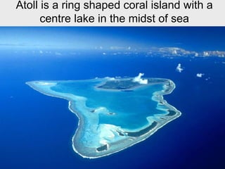
- 60. Atoll is a ring shaped coral island with a centre lake in the midst of sea
- 61. Another type of Coral Reef Atoll
- 62. Coral reefs exist only in these areas!
- 63. Hook typed atoll
- 64. Physical properties of sea water
- 65. Temperature structure with depth in the open ocean Warmer at top, cooler with depth Thermocline – region of rapid change of temperature; permanent seasonal diurnal Higher temperature, lower density
- 68. Depth of certain isotherms as a function of month Vertical temperature profiles month by month
- 69. Salinity Total amount of solid material dissolved in water- Traditional definition Typical salinity is 3.5% or 35o/oo o/oo or parts per thousand (ppt) = grams of salt per kilogram of water g/Kg Six elements make up 99% of dissolved solids in seawater Fig. 5.12
- 70. Ocean Chemistry and Currents I. Chemistry of Ocean Water 96.5% Water Common salts: chlorides, sulfates Sodiumions(Na+)-31% Magnesiumions(Mg2+)-4% Calciumions(Ca2+)-1% Potassiumions(K+)-1% Chloride ions(Cl-)-55% Sulfateions(SO4 2-)-7% Salts come from erosional forces, runoff from the continents 3.5% Salts
- 72. Salinity Can you fill the gaps about ocean salinity? The average salinity of seawater is _____ ppt. Therefore, for every 1,000 ml water, there are ___ grams of dissolved salts. The most abundant salt in seawater is ________, but there are many other salts present in the form of ions. Near the equator salinity is __________ than average due to ___________________. Near the poles salinity is __________ than average due to _______________. In the Mediterranean the salinity is __________than average due to __________. NaCl 35 35 lower greater precipitation lower melting sea ice higher evaporation
- 73. How much is the salinity here ? A. 35 ppt B. 34 ppt C. 36 ppt
- 74. Global range of salinity
- 75. Conductivity-Temperature-Depth (CTD) T accuracy: ±0.001°C C accuracy: 0.0003 S/m ~ 0.0024 on PSS Response time: Time required for instrument to respond to temperature of a new environment.
- 76. Which ocean is most saline?
- 77. Surface ocean variation of salinity Polar regions: salinity is lower due to lots of rain/snow and runoff Mid-latitudes: salinity is higher due to high rate of evaporation Equator: salinity is lower due to lots of rain
- 78. Variation of T,S & σT with latitude
- 80. Vertical distribution of salinity
- 81. Density of water Density of water increases as temperature decreases Density of ice is less than density of water From 4oC to 0oC density of water decreases as temperature decreases
- 82. Density of water
- 84. Density of seawater in polar oceans Salinity has greatest influence on density in polar oceans Polar ocean is almost isothermal
- 85. A TS-diagram showing densities at different depths
- 86. Relation of Density and salinity 1.022 to 1.030 g/cm3 surface seawater Ocean layered according to density Density seawater controlled by temperature, salinity, and pressure σt = -0.093 + 0.8149 S –0.000482 S2 + 0.0000068 S3 σt = -0.069 + 1.4708 Cl –0.001570 Cl2 + 0.0000398 Cl3
- 90. Label the three ocean layers in the diagram below. Mixed layer Thermocline Bottom layer
- 91. Can you guess the origin of bottom water in low latitudes?
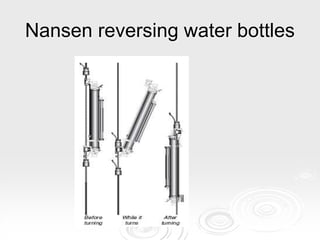
- 92. Reversing thermometers & Nansen Reversing water bottles
- 94. Nansen reversing water bottles
- 95. Nansen and Niskin samplers
- 96. Expendable Bathythermograph Accuracy = ±0.1°C (??)
- 97. Mooring
- 98. ARGO program
- 100. ARGO Program Up to 3000 floats in upper 2000 m of ocean International collaboration of about 23 countries Used with Jason satellite
- 101. ARGO float
- 102. Current Velocity- ADCP Current meters Acoustic Doppler Current Profiler (ADCP)
- 103. Ocean SST February
- 104. Ocean SST in May
- 105. Chapter Review 1. What is the average salinity of seawater? 2. What is the deepest area of the seafloor? 3. What is the largest ocean? 4. Why is the ocean “blue”? 5. What is the force responsible for surface currents? 6. What causes density currents? 7. What causes tides? 8. List the 3 tidal patterns. 9. What is the highest part of a wave called? 10.Name the most saltiest ocean . 35 ppt trench Pacific shorter wavelengths not absorbed wind differences in temperature and salinity gravity of the sun and moon diurnal, semidiurnal, mixed crest Atlantic
- 106. Any Questions?