How to Easily Read and Write CityGML Data (Without Coding)
0 likes1,872 views

The document discusses how to read and write CityGML data without coding, covering topics such as CityGML's context as a digital twin, its strengths and limitations, and comparisons with CityJSON. It explains typical workflows for working with CityGML, its enhancements in FME, various case studies, and the interoperability between CityGML and other standards for building and indoor mapping. Additionally, it highlights practical applications and customer use cases in urban planning and data processing challenges.


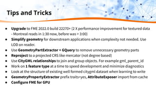

![CityGML Writing Tips
● Prepare your source data: geometry and source attributes
● Add CityGML specific attributes and geometry properties
○ Format Attribute citygml_lod_name
○ lodxSolid[1..4], lodxMultiSurface[2..4], lodxGeometry[0..5]
● Build relationship between features
○ Example: 'Building' address 'Address'
○ Use gml_id and gml_parent_id for relation
○ Format Attribute citygml_feature_role
● Model CityGML entities by FME feature types
○ Import CityGML entities from writer or from an existing CityGML dataset
○ Make sure you use exact case for all property names boundedBy ≠ Boundedby](https://image.slidesharecdn.com/howtoeasilyreadandwritecitygmldatawithoutcoding-jan272022-220127221624/85/How-to-Easily-Read-and-Write-CityGML-Data-Without-Coding-88-320.jpg)


How to Easily Read and Write CityGML Data (Without Coding)
- 1. How to Easily Read and Write CityGML Data (Without Coding)
- 2. Meet the Presenters Don Murray Co-Founder Dean Hintz Product Manager, XML Team & Open Standards To chat with about anything data, anytime info@safe.com
- 3. Agenda What weʼre covering today. ● Setting the Scene: CityGML context ● CityGML as Digital Twin ● CityJSON and CityGML ● Typical CityGML Workflows ● FME and CityGML, Indoor, BIM, and 3D ● Demos ○ Inspection, GeoBIM, Indoor, and more ● Trends and Conclusions ● Next Steps
- 4. Setting the Scene World of 3D, Data, BIM, GEOBIM etc. ● Where does CityGML play? ● What are itʼs strengths, ● What are itʼs limitations?
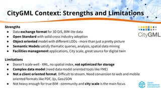
- 5. CityGML Context: Strengths and Limitations Strengths ● Data exchange format for 3D GIS, BIM-lite data ● Open Standard with solid cross industry adoption ● Object oriented model with different LODs - more than just a pretty picture ● Semantic Models satisfy thematic queries, analysis, spatial data mining ● Facilities management applications, City scale, great source for digital twin Limitations ● Doesnʼt scale well - XML, no spatial index, not optimized for storage ● Complex data model (need data model oriented tools like FME) ● Not a client oriented format. Difficult to stream. Need conversion to web and mobile oriented formats like PDF, 3js, GeoJSON ● Not heavy enough for true BIM - community and city scale is the main focus
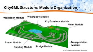
- 6. CityGML Structure: Module Organization © KIT – Karlsruher Institute of Technology
- 7. CityGML Structure: Semantics and Geometry (C) by T.H. Kolbe © T.H. Kolbe © Filip Biljecki, Hugo Ledoux, Jantien Stoter
- 8. Setting the Scene PT II Common cases where CityGML adds value. ● Digital Twin ● 3D GIS for City Systems and Urban planning
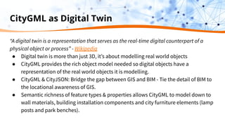
- 9. CityGML as Digital Twin “A digital twin is a representation that serves as the real-time digital counterpart of a physical object or process” - Wikipedia ● Digital twin is more than just 3D, itʼs about modelling real world objects ● CityGML provides the rich object model needed so digital objects have a representation of the real world objects it is modelling. ● CityGML & CityJSON: Bridge the gap between GIS and BIM - Tie the detail of BIM to the locational awareness of GIS. ● Semantic richness of feature types & properties allows CityGML to model down to wall materials, building installation components and city furniture elements (lamp posts and park benches).
- 10. CityJSON and CityGML CityJSON advantages ● Smaller - about ⅙ the size ● No application schema (good and bad) ● Simpler geometry implementation ● Better for thinner clients CityGML advantages ● Schema supports validation of both geom and schema ● Easily extensible with ADEʼs via GML app schema ● More comprehensive implementation of the CityGML standard ● Richer object model, ability to define xlinks
- 11. Typical CityGML Workflows ● Data Inspection and Evaluation ● CityGML model generation ● Creating LODs ● 3D data generation from 2D ● 2.5D draping ● 3D extrusion ● Database loading ● BIM to GIS ● CityGML to CityJSON ● Export to client formats (PDF/KML)
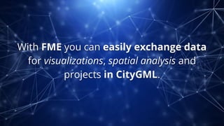
- 12. With FME you can easily exchange data for visualizations, spatial analysis and projects in CityGML.
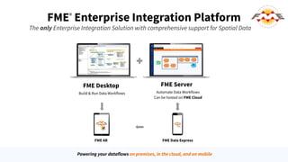
- 13. FME® Enterprise Integration Platform FME Desktop Build & Run Data Workflows FME Server Automate Data Workflows Can be hosted on FME Cloud FME Data Express Powering your dataflows on premises, in the cloud, and on mobile The only Enterprise Integration Solution with comprehensive support for Spatial Data FME AR
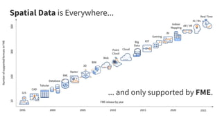
- 14. Spatial Data is Everywhere... ... and only supported by FME.
- 15. Our Strength We deliver the power of spatial data to the worldʼs decision makers.
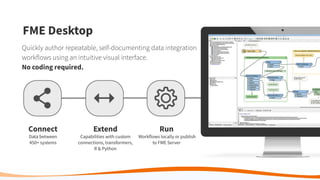
- 16. Connect Data between 450+ systems Extend Capabilities with custom connections, transformers, R & Python Run Workflows locally or publish to FME Server FME Desktop Quickly author repeatable, self-documenting data integration workflows using an intuitive visual interface. No coding required.
- 17. FME & CityGML - Highlights and Recent Enhancements
- 18. FME Enhancements: CityGML ● CityJSON ● CityGML v3* (via GML R/W) ● Geometry by reference (xlinked) ● New LODs to Read parameter ● Coordinate precision parameter on Writer ● Improved geometry support ● Performance optimizations ● GML core improvements ● OGC Certification (GML but no test suite for CityGML yet) *In progress
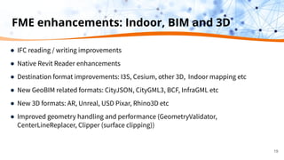
- 19. FME enhancements: Indoor, BIM and 3D ● IFC reading / writing improvements ● Native Revit Reader enhancements ● Destination format improvements: I3S, Cesium, other 3D, Indoor mapping etc ● New GeoBIM related formats: CityJSON, CityGML3, BCF, InfraGML etc ● New 3D formats: AR, Unreal, USD Pixar, Rhino3D etc ● Improved geometry handling and performance (GeometryValidator, CenterLineReplacer, Clipper (surface clipping)) 19
- 20. Demo Time
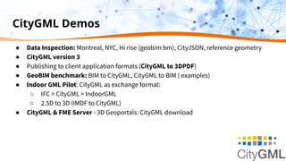
- 21. CityGML Demos ● Data Inspection: Montreal, NYC, Hi rise (geobim bm), CityJSON, reference geometry ● CityGML version 3 ● Publishing to client application formats (CityGML to 3DPDF) ● GeoBIM benchmark: BIM to CityGML, CityGML to BIM ( examples) ● Indoor GML Pilot: CityGML as exchange format: ○ IFC > CityGML > IndoorGML ○ 2.5D to 3D (IMDF to CityGML) ● CityGML & FME Server - 3D Geoportals: CityGML download
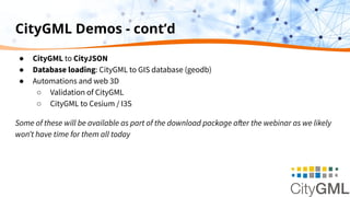
- 22. CityGML Demos - cont’d ● CityGML to CityJSON ● Database loading: CityGML to GIS database (geodb) ● Automations and web 3D ○ Validation of CityGML ○ CityGML to Cesium / I3S Some of these will be available as part of the download package after the webinar as we likely wonʼt have time for them all today
- 23. Visualizing and Inspecting CityGML and CityJSON
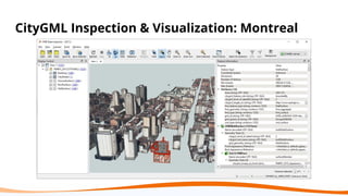
- 24. CityGML Inspection & Visualization: Montreal
- 25. CityJSON Inspection & Visualization: Rotterdam
- 26. CityJSON Inspection & Visualization: Railways
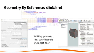
- 27. Geometry By Reference: xlink:href Building geometry links to component walls, roof, floor
- 29. CityGML 3 ● More flexible LOD & geometry model, addition of point clouds ● Time and versioning ● BIM lite - support for Spaces - better interop with IFC ● Indoor friendly - addition of building units and storeys (level) - better interop with INSPIRE and IndoorGML ● Improvements to transportation objects for traffic, and driving simulations & autonomous systems, road and railway facility management ● Separate conceptual model from encoding (GML, JSON and DB likely) ○ https://github.com/opengeospatial/CityGML-3.0Encodings ○ https://link.springer.com/article/10.1007/s41064-020-00095-z
- 30. CityGML3 with GML Reader
- 31. CityGML3 with GML Reader: Transportation - OpenDRIVE
- 32. Publishing CityGML to Client Formats: 3DPDF
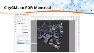
- 33. CityGML to PDF: Montreal
- 34. CityGML to PDF: Montreal
- 35. CityGML to PDF: Montreal Geometry Transform: deaggregate, triangulate, convert to mesh, group Schema Transform: Expose, create attributes and set geometry traits
- 36. CityGML to PDF: Montreal
- 38. GeoBIM Benchmark Purpose: Evaluate maturity of GeoBIM standards and tool implementations IFC and CityGML Testbed ● Task 1: IFC ● Task 2: IFC Georeferencing ● Task 3: CityGML ● Task 4: Conversion Lead research coordinator: Francesca Noardo, TU Delft Sponsored by ISPRS, EuroSDR https://3d.bk.tudelft.nl/projects/geobim-benchmark/
- 39. ● Open standard for Building Information Models ● Both STEP and XML ● Added support for the upcoming IFC 4x3 ● Working with buildingSMART on test beds CityGML ● Open standard for city information models ● FME has unparalleled support for CityGML ( v 1,2,3) ● Full support for ADEʼs (Energy, Noise, IMGeo) ● Recently added CityJSON support ● Active with CityGML SWG at OGC IFC
- 40. IFC & CityGML: Modelling Challenge *Source - slide from: Thomas H. Kolbe - joint work with Claus Nagel & Alexandra Stadler
- 41. Method: Read / write GML using CityGML application schemas & ADEʼs Results: ● Able to read all the datasets evaluated ● Read and wrote all element types ● Good georeferencing support Challenges: ● Rotterdam: Data Quality issues - surface errors within Building,BuildingPart. Textures incorrect - errors: Non-Planar surfaces, and Surface not closed (GeometryValidator) ● Possibility for user error - id, parent ids, semantics; size of schema Task 3: CityGML
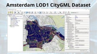
- 42. Amsterdam LOD1 CityGML Dataset
- 43. Geometry Quality - Rotterdam LOD1, LOD2 CityGML
- 44. Rotterdam LOD1, LOD2 CityGML Dataset
- 45. Rotterdam LOD1, LOD2 CityGML - Geolocation
- 46. IfcWall to CityGML WallSurface ConvertGeometry custom transformer
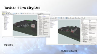
- 47. Task 4: IFC to CityGML Input IFC Output CityGML
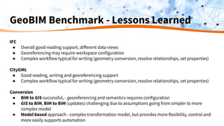
- 48. GeoBIM Benchmark - Lessons Learned IFC ● Overall good reading support, different data views ● Georeferencing may require workspace configuration ● Complex workflow typical for writing (geometry conversion, resolve relationships, set properties) CityGML ● Good reading, writing and georeferencing support ● Complex workflow typical for writing (geometry conversion, resolve relationships, set properties) Conversion ● BIM to GIS successful, - georeferencing and semantics requires configuration ● GIS to BIM, BIM to BIM (updates) challenging due to assumptions going from simpler to more complex model ● Model based approach - complex transformation model, but provides more flexibility, control and more easily supports automation
- 49. Supporting Indoor Mapping with CityGML: IndoorGML Pilot
- 50. Indoor Mapping IMDF ( Developed by Apple) ● OGC Open Standard (JSON) ● Strict Business Rules ● Designed for map display ArcGIS Indoors ● Esriʼs Indoor Mapping System ● Designed for data storage/editing IndoorGML ● OGC Open Standard (GML) ● Designed for data transfer
- 51. OGC Indoor GML Pilot: Design Goal: Convert building interior scans into standardized building datasets able to support indoor mapping Design: Read LIDAR scans and convert to OGC IndoorGML for use by navigation services and clients 1. Read LIDAR point clouds 2. Interpret features relevant to navigation: walls, doors, rooms 3. Generate CityGML with spaces and features 4. Enrich with public safety information (Public Safety ADE) 5. Convert CityGML to IndoorGML (PS extension) 6. Add navigation network to IndoorGML state and transition layers 7. Post results to CSW; Create a navigation service on top 8. Create clients to interact with navigation service
- 52. OGC Indoor GML Pilot: Implementation ● Public Safety CityGML ADE and Indoor GML PS extension had to be developed and tested. ○ In parallel with PS extension development, early testing conducted with CityGML and IndoorGML core ● Multiple tools and platforms to filter and clean LIDAR scans, convert to 3D geometries, and simplify: ○ TICA with GML (direct edit of GML) ○ Revit with IFC (extra conversion step) ● Once data was in a standard geospatial format (CityGML or IFC), conversion to IndoorGML was automated, after model based conversions were configured and tested
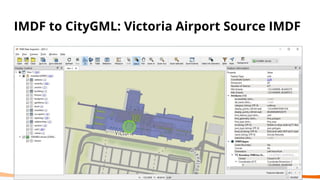
- 53. IMDF to CityGML: Victoria Airport Source IMDF
- 54. IMDF to CityGML: Victoria Airport Workspace
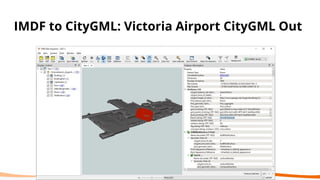
- 55. IMDF to CityGML: Victoria Airport CityGML Out
- 56. Victoria Airport Public Safety ADE
- 57. Indoor GML Pilot: CityGML for data exchange IFC to CityGML to IndoorGML
- 58. Indoor Pilot: Source - IfcSpace
- 59. Indoor Pilot: IFC to CityGML Workspace
- 60. IFC to CityGML: Geometry Transform & Clean Filter complex objects to get just vertical walls ● Compute surface normal on all surfaces ● -0.1 < surfaceZ < 0.1 produced vertical wall faces ● surfaceZ > 0.5 produced the top of floors ● surfaceZ < - 0.5 produced the bottom of the roof or ceiling
- 61. GeometryPartExtractor GQuery ConvertGeometry custom transformer IFC to CityGML: Geometry Transform Results were sufficient to generate CityGML from IFC
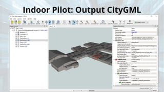
- 62. Indoor Pilot: Output CityGML
- 63. Indoor Pilot: CityGML to IndoorGML FME Workspace
- 64. Geometry Transformations Dissolve, Generalize, Snap, Aggregate
- 65. Schema Transformations Attribute Mapping Value Mapping Conditional Mapping
- 66. IndoorGML Output
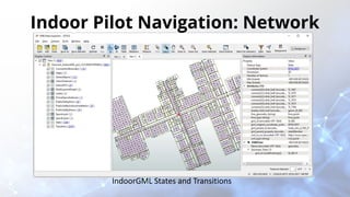
- 67. Indoor Pilot Navigation: Network IndoorGML States and Transitions
- 68. Indoor Pilot Navigation: ShortestPathFinder From – To vector and associated shortest path
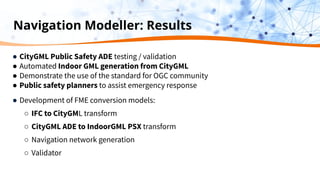
- 69. Navigation Modeller: Results ● CityGML Public Safety ADE testing / validation ● Automated Indoor GML generation from CityGML ● Demonstrate the use of the standard for OGC community ● Public safety planners to assist emergency response ● Development of FME conversion models: ○ IFC to CityGML transform ○ CityGML ADE to IndoorGML PSX transform ○ Navigation network generation ○ Validator
- 70. IndoorGML Pilot Lessons Learned ● It is feasible to convert from LIDAR to IFC, CityGML and IndoorGML ● Extraction of features / spaces from PC a challenge for automation, though some methods hold promise ● Model based transformation tools support rapid testing and prototyping of new schemas. Once workflow was developed, easy to apply to new building datasets. ● IndoorGML data model complexity poses implementation challenges. Still, schema enables validation automation ● Accurate doors critical to correct navigation network. In some cases misclassified doors had to be reclassified. ● Space concept is vital for integration across standards.
- 71. CityGML to CityJSON https://www.cityjson.org/specs/1.1.0/ https://www.cityjson.org/conformance/v20/ Simplified property and geometry model Walls, Roofs etc are children of Building and written as BuildingPart gml_id > fid gml_parent_id > cityjson_parents{0} Building: cityjson_children{}
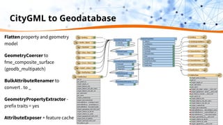
- 72. CityGML to Geodatabase Flatten property and geometry model GeometryCoercer to fme_composite_surface (geodb_multipatch) BulkAttributeRenamer to convert . to _ GeometryPropertyExtractor - prefix traits = yes AttributeExposer + feature cache
- 73. CityGML Stored in Geodatabase Flattened property and geometry model - Geodb_multipatch Spatially indexed CityGML and geometry properties stored as fields in database record Need to rebuild object hierarchy to write back to CityGML
- 75. Partners ● ESRI: CityGML to I3S: Streaming fast 3D city data in ArcGIS ● Autodesk: FME CityGML Importer: Autodesk ● con terra: ○ Using CityGML in ArcGIS ○ https://www.conterra.de/bim (German) ● virtualcitySYSTEMS: ○ Spotlight ○ VC Warehouse
- 76. Customer Use Cases City of Karlsruhe ● Generation of CityGML data using FME New York City ● AppGeo's NYC project ● FME UC 2016: Stranger in a Strange Land;Exploring 3D and CityGML Berlin 3D City Download Portal
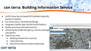
- 77. con terra: Building Information Service ● ArcGIS Scene Service based 3D CityModel (originally based on CityGML) ● For all Germany (> 50 million buildings) ● Integrates CityGML data into the ArcGIS Platform ● Quality assurance and improvements ● enhancing the model through e.g. volume and height calculations ● Typical use cases: ● Building valuation for insurance ● urban planning ● telecommunications (antenna planning)
- 78. VC Warehouse
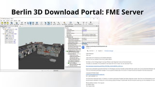
- 79. Berlin 3D Download Portal: FME Server Download options: Extents mesh or LOD model Model: (textures, tiles, generic attributes) Format: CityGML, PDF, KMZ, SHP, 3DS, OBJ, COLLADA, DWG, GeoDB, Geopackage, IFC, FMEAR, FBX, GLTF, STL
- 80. Berlin 3D Download Portal: FME Server
- 81. The Goal NYCʼs IT (DoITT) needed a 3D building massing model for the Cityʼs 1,000,000 buildings The Obstacles Massive volumes of data and huge data quality challenges The Solution AppGeo used FME to model all buildings in 3D CityGML. AppGeo then automated analysis of the CityGML making QA reports. The Result Access to 3D building models, planimetric data along with viewing tools is now provided by the City.
- 82. The Goal Property Register Department needed an efficient and automated way of processing the 3D data it had collected The Obstacles Massive volumes of data: urban area of 173 km², with 27 districts and a total population of approximately 300,000. The Solution Building data is enriched and then converted into CityGML format & run repeatedly each time data isrequired. The Result Now able to transfer 3D data quickly and efficiently into CityGML using a standardised workflow.
- 84. CityGML Tips & Resources
- 85. Tips and Tricks ● Upgrade to FME 2022.0 build 22270+ (2 X performance improvement for textured data - Montreal reads in 1:30 now, before was > 3:00) ● Simplify geometry for downstream applications when complexity not needed. Use LOD on reader. ● Use GeometryPartExtractor + GQuery to remove unnecessary geometry parts ● Reproject to a projected CRS like mercator (not degree based) ● Use CityGML relationships to join and group objects. For example gml_parent_id ● Work on 1 feature type at a time to speed development and minimize diagnostics ● Look at the structure of existing well formed citygml dataset when learning to write ● GeometryPropertyExtractor prefix traits=yes, AttributeExposer import from cache ● Configure FME for GPU
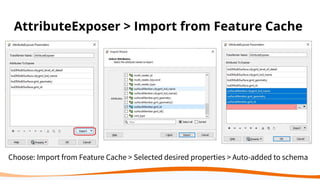
- 86. AttributeExposer > Import from Feature Cache Choose: Import from Feature Cache > Selected desired properties > Auto-added to schema
- 87. NVIDIA Control Panel for Data Inspector GPU Choose: High Performance Processor
- 88. CityGML Writing Tips ● Prepare your source data: geometry and source attributes ● Add CityGML specific attributes and geometry properties ○ Format Attribute citygml_lod_name ○ lodxSolid[1..4], lodxMultiSurface[2..4], lodxGeometry[0..5] ● Build relationship between features ○ Example: 'Building' address 'Address' ○ Use gml_id and gml_parent_id for relation ○ Format Attribute citygml_feature_role ● Model CityGML entities by FME feature types ○ Import CityGML entities from writer or from an existing CityGML dataset ○ Make sure you use exact case for all property names boundedBy ≠ Boundedby
- 89. CityGML Demos & Resources - from Safe ● CityGML on Safe.com ● Writing CityGML tutorial ● FME & 3D Article ● 3D Tutorial ● BIM tutorial (IFC toi CityGML) ● BIM to GIS Advanced ● Indoor GML Pilot
- 90. CityGML Demos & Resources - more ● con terra & Virtual City Systems: FMEHub CityGML Solution Templates ● Awesome CityGML https://github.com/OloOcki/awesome-citygml ● Simplified CityGML-Base 3d Space Model for Indoor Applications publication ● CityGML to I3S: Streaming fast 3D city data in ArcGIS ● From CityGML 3D City Model to 3D Web Application (CityGML to Cesium with FME) ● Safe CityGML Jan 2022 blog ● https://towardsdatascience.com/open-source-3d-semantical-building-models-in-2020- f47c91f6cd97
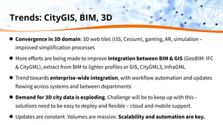
- 91. Trends: CityGIS, BIM, 3D ● Convergence in 3D domain: 3D web tiles (I3S, Cesium), gaming, AR, simulation – improved simplification processes ● More efforts are being made to improve integration between BIM & GIS (GeoBIM: IFC & CityGML), extract from BIM to lighter profiles or GIS, CityGML3, InfraGML ● Trend towards enterprise-wide integration, with workflow automation and updates flowing across systems and between departments ● Demand for 3D city data is exploding. Challenge will be to keep up with this – solutions need to be easy to deploy and flexible – cloud and mobile support. ● Updates are constant. Volumes are massive. Scalability and automation are key.
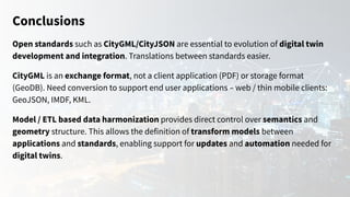
- 92. Conclusions Open standards such as CityGML/CityJSON are essential to evolution of digital twin development and integration. Translations between standards easier. CityGML is an exchange format, not a client application (PDF) or storage format (GeoDB). Need conversion to support end user applications – web / thin mobile clients: GeoJSON, IMDF, KML. Model / ETL based data harmonization provides direct control over semantics and geometry structure. This allows the definition of transform models between applications and standards, enabling support for updates and automation needed for digital twins.
- 93. Conclusions Continued collaboration and across BIM, 3D and GIS communities is essential. Data models need not converge as they serve different applications (3D GIS, CityGML3, CityJSON, AR). Approaches to enterprise automation for whole digital twin data life cycle: generation, extraction, cleaning, conversion templates between open and industry standards, validation, updates, publication, & cloud services - moving beyond a file basis to services. Emerging opportunities for indoor & underground mapping, AR, VR, 3D scanning.
- 94. Next Steps Download FME 2021.2 Download the workspaces from this webinar Apply it to your own data to manage changes Free Trial | Upgrade Contact us. We would love to chat with you about anything data info@safe.com
- 95. Claim Your Community Badge Get community badges for watching webinars! fme.ly/WebinarBadge Todayʼs Code: CFSBP
- 96. The Peak of Data Integration 2022 UC August 24-26, 2022 Vancouver, Canada Appy to present | Register now
- 97. FME World Tour 2022 March 22 - June 24 | 45+ Events View the Tour Schedule & Register Now
- 98. Check out our upcoming & on-demand webinars: safe.com/webinars
- 99. Q&A
- 100. Thank you! Connect with us at info@safe.com or in the Community Download FME 2021.2 Free Trial | Upgrade Connect with us for more FME Please share your feedback with us through the webinar survey!