SlideShare a Scribd company logo
Austin Community Tree Program Map Book
ii
[This page is intentionally left blank for printing purposes]
iii
Contents
About This Map Book ………………………………………………………………………………iv
Map Book Key ……………………………………………………………………………………….v
Technical Map Information ………………………………………………………………………...vi
Total ACT Program Benefits …..………………………………………………………………….vii
Overview Map of Austin …………………………………………………………………………..viii
Map of Neighborhood Planning Areas ……………………………………………………………ix
Tree Canopy Growth ………………………………………………………………………………..1
Carbon Sequestration 2006-2015 ……………………………………………………………….15
Energy Conservation 2006-2015 ………………………………………………………………...29
iv
About This Map Book
This map book is divided into four sections. The first three sections each contain one map
for each neighborhood that has been selected for the Austin Community Tree (ACT)
Program and shows how the program benefits residents who planted ACT Program trees
and Austin as a whole. The final section contains a table showing expected growth of ACT
Program trees to date and onward to 2025.
To bring you this information, the City of Austin Planning and Zoning Department, in
conjunction with the Texas State University Geography Department, processed tree
coverage data from aerial imagery and data on ACT Program trees delivered using
geographic information systems and the National Tree Benefit Calculator (NTBC). The
NTBC is a computer application that calculates how much a single tree benefits water and
air quality and energy consumption in one year.
Each of the first three sections of this book displays in maps the results of one of three
NTBC or geographic information system analyses by neighborhood:
 The ground surface area where there was increase in tree canopy (the area made
up of trees’ leaves and outermost branches);
 The number of pounds (lbs.) of carbon dioxide (CO2) that ACT Program trees keep
stored away—or sequestered—in their trunks, branches, and leaves since 2006; or
 The number of kilowatt hours (kWh) of electrical energy Austin residents have saved
since 2006 by running their air conditioners less, thanks to the shade ACT Program
trees provide.
Results of these calculations are displayed in tables as well as maps (see page vii).
The percentage of increase was found by dividing overall canopy gain by the canopy area
in 2006. NTBC analyses of CO2 sequestered and energy conserved consisted of multiplying
the values determined by the NTBC, numbers of ACT Program trees, and the numbers of
years they have been planted in the ground. Circle symbols in the Carbon Sequestration
and Energy Conservation sections represent tree benefits at one address and indicate a
range of pounds or kWh’s. Map pages also show total pounds of CO2 and total kWh of
electrical energy conserved over the entire featured neighborhood. These values are in
green directly below the page title (see the Map Book Key).
Predicted growth by 2025 was calculated based on the assumption that individual trees
grow one foot of canopy each year. Values for each neighborhood and all neighborhoods
combined are displayed in a table rather than a map as it is not possible to predict exactly
where the canopy growth will occur with the level of accuracy achieved in the first section of
the map book.
v
Map Book Key
Actual location
of canopy
growth
between 2006
and 2010
Addresses
where ACT
Program trees
were delivered
Title with
neighborhood
Map page
number
Neighborhood
boundary
Neighborhood
locator within
Austin city limits
Total CO2
sequestered
or energy
conserved
Neighborhood
boundaries
Carbon
sequestered by
ACT Program
trees at single
address
(symbols show
a range)
Bordering
neighborhood
name
Neighborhood
locator within
Austin city limits
Bordering
neighborhood
boundary
vi
Technical Map Information
Data Source: City of Austin
Coordinate System: State Plane Texas Central FIPS 4203 Feet
Projection: Lambert Conformal Conic
Datum: North American Datum 1983
The Austin Community Tree Program Map Book dataset is for planning purposes only. It
does not represent individual trees, nor their species type, or any metric for tree canopy
height. This product is for informational purposes and may not have been prepared for or be
suitable for legal, engineering, or surveying purposes. It does not represent an on-the-
ground survey and represents only the approximate relative location of property boundaries.
This product has been produced for the Planning and Zoning Department for the sole
purpose of geographic reference. No warranty is made by the City of Austin or the Texas
State Geography Department regarding specific accuracy or completeness.
vii
Total ACT Program Benefits
Total growth and reduction were calculated for each individual neighborhood and all
combined. Reduction was subtracted from total growth to account for canopy that
disappeared between 2006 and 2010. Analysis of the change in canopy determined
overall growth of 16.5%.
Planning Area Total CO2 (lbs.) Total Energy (kWh)
Coronado Hills 8,696 3,532
Crestview 27,540 10,800
East Cesar Chavez 7,580 3,400
East Congress 14,130 5,306
Franklin Park 10,890 4,524
McKinney 5,034 2,079
Montopolis 25,152 10,590
N. Austin Civic Association 10,620 4,244
Old West Austin 10,152 4,293
Rosewood 14,448 5,008
St. John 2,016 880
Sweetbriar 9,982 3,724
West Congress 16,842 6,650
Wooten 9,020 3,270
Totals 173,034 68,657
Planning Area
Total
Trees
Canopy Growth 2014-2015
(ac)
Canopy Growth 2014-2025
(ac)
Coronado Hills 307 0.08 0.16
Crestview 408 0.17 0.26
East Cesar Chavez 231 0.07 0.12
East Congress 295 0.10 0.17
Franklin Park 497 0.13 0.24
McKinney 231 0.06 0.11
Montopolis 598 0.19 0.33
N. Austin Civic Assn. 749 0.17 0.34
Old West Austin 175 0.07 0.11
Rosewood 253 0.09 0.15
St. John 68 0.02 0.03
Sweetbriar 210 0.07 0.12
West Congress 347 0.12 0.20
Wooten 134 0.06 0.09
Totals 4503 1.40 2.43
viii
ix
Page 1Canopy Growth 2006-2010: CORONADO HILLS
Total Canopy Growth
Tree Delivery Locations
Canopy Growth
Neighborhoods
±
State Plane, Texas Central FIPS 4203 ft., Lamber Conformal Conic, North American Datum 1983
Prepared by Green City GeoTech for the City of Austin Forestry Division
Data retrieved from the City of Austin
December 2015
0 0.2 0.40.1
Miles
Page 2Canopy Growth 2006-2010: CRESTVIEW
Total Canopy Growth
Tree Delivery Locations
Canopy Growth
Neighborhoods
±
State Plane, Texas Central FIPS 4203 ft., Lamber Conformal Conic, North American Datum 1983
Prepared by Green City GeoTech for the City of Austin Forestry Division
Data retrieved from the City of Austin
December 2015
0 0.25 0.50.125
Miles
Page 3Canopy Growth 2006-2010: EAST CESAR CHAVEZ
Total Canopy Growth
Tree Delivery Locations
Canopy Growth
Neighborhoods
±
State Plane, Texas Central FIPS 4203 ft., Lamber Conformal Conic, North American Datum 1983
Prepared by Green City GeoTech for the City of Austin Forestry Division
Data retrieved from the City of Austin
December 2015
0 0.2 0.40.1
Miles
Page 4Canopy Growth 2006-2010: EAST CONGRESS
Total Canopy Growth
Tree Delivery Locations
Canopy Growth
Neighborhoods
±
State Plane, Texas Central FIPS 4203 ft., Lamber Conformal Conic, North American Datum 1983
Prepared by Green City GeoTech for the City of Austin Forestry Division
Data retrieved from the City of Austin
December 2015
0 0.3 0.60.15
Miles
Page 5Canopy Growth 2006-2010: FRANKLIN PARK
Total Canopy Growth
Tree Delivery Locations
Canopy Growth
Neighborhoods
±
State Plane, Texas Central FIPS 4203 ft., Lamber Conformal Conic, North American Datum 1983
Prepared by Green City GeoTech for the City of Austin Forestry Division
Data retrieved from the City of Austin
December 2015
0 0.4 0.80.2
Miles
Page 6Canopy Growth 2006-2010: MCKINNEY
Total Canopy Growth
Tree Delivery Locations
Canopy Growth
Neighborhoods
±
State Plane, Texas Central FIPS 4203 ft., Lamber Conformal Conic, North American Datum 1983
Prepared by Green City GeoTech for the City of Austin Forestry Division
Data retrieved from the City of Austin
December 2015
0 0.5 10.25
Miles
Page 7Canopy Growth 2006-2010: MONTOPOLIS
Total Canopy Growth
Tree Delivery Locations
Canopy Growth
Neighborhoods
±
State Plane, Texas Central FIPS 4203 ft., Lamber Conformal Conic, North American Datum 1983
Prepared by Green City GeoTech for the City of Austin Forestry Division
Data retrieved from the City of Austin
December 2015
0 0.45 0.90.225
Miles
Page 8Canopy Growth 2006-2010: NORTH AUSTIN CIVIC ASSOCIATION
Total Canopy Growth
Tree Delivery Locations
Canopy Growth
Neighborhoods
±
State Plane, Texas Central FIPS 4203 ft., Lamber Conformal Conic, North American Datum 1983
Prepared by Green City GeoTech for the City of Austin Forestry Division
Data retrieved from the City of Austin
December 2015
0 0.55 1.10.275
Miles
Page 9Canopy Growth 2006-2010: OLD WEST AUSTIN
Total Canopy Growth
Tree Delivery Locations
Canopy Growth
Neighborhoods
±
State Plane, Texas Central FIPS 4203 ft., Lamber Conformal Conic, North American Datum 1983
Prepared by Green City GeoTech for the City of Austin Forestry Division
Data retrieved from the City of Austin
December 2015
0 0.25 0.50.125
Miles
Page 10Canopy Growth 2006-2010: ROSEWOOD
Total Canopy Growth
Tree Delivery Locations
Canopy Growth
Neighborhoods
±
State Plane, Texas Central FIPS 4203 ft., Lamber Conformal Conic, North American Datum 1983
Prepared by Green City GeoTech for the City of Austin Forestry Division
Data retrieved from the City of Austin
December 2015
0 0.3 0.60.15
Miles
Page 11Canopy Growth 2006-2010: ST. JOHN
Total Canopy Growth
Tree Delivery Locations
Canopy Growth
Neighborhoods
±
State Plane, Texas Central FIPS 4203 ft., Lamber Conformal Conic, North American Datum 1983
Prepared by Green City GeoTech for the City of Austin Forestry Division
Data retrieved from the City of Austin
December 2015
0 0.3 0.60.15
Miles
Page 12Canopy Growth 2006-2010: SWEETBRIAR
Total Canopy Growth
Tree Delivery Locations
Canopy Growth
Neighborhoods
±
State Plane, Texas Central FIPS 4203 ft., Lamber Conformal Conic, North American Datum 1983
Prepared by Green City GeoTech for the City of Austin Forestry Division
Data retrieved from the City of Austin
December 2015
0 0.25 0.50.125
Miles
Page 13Canopy Growth 2006-2010: WEST CONGRESS
Total Canopy Growth
Tree Delivery Locations
Canopy Growth
Neighborhoods
±
State Plane, Texas Central FIPS 4203 ft., Lamber Conformal Conic, North American Datum 1983
Prepared by Green City GeoTech for the City of Austin Forestry Division
Data retrieved from the City of Austin
December 2015
0 0.3 0.60.15
Miles
Page 14Canopy Growth 2006-2010: WOOTEN
Total Canopy Growth
Tree Delivery Locations
Canopy Growth
Neighborhoods
±
State Plane, Texas Central FIPS 4203 ft., Lamber Conformal Conic, North American Datum 1983
Prepared by Green City GeoTech for the City of Austin Forestry Division
Data retrieved from the City of Austin
December 2015
0 0.35 0.70.175
Miles
Carbon Sequestration 2006-2015: CORONADO HILLS
IH35
US183
MO-PAC
LOOP360
BEN WHITE
FM
2222
US 290
SH 71
CESAR CHAVEZ
KOENIG
ANDERSON
Page 15
Total Carbon Sequestration (lbs.)
12 - 50
51 - 100
101 - 168
169 - 444
445 - 1312
Neighborhood of Interest
Other Neighborhoods
±
State Plane, Texas Central FIPS 4203 ft., Lamber Conformal Conic, North American Datum 1983
Prepared by Green City GeoTech for the City of Austin Forestry Division
Data retrieved from the City of Austin
December 2015
ST.JOHN
Total: 8696 lbs.
0 0.2 0.40.1
Miles
Carbon Sequestration 2006-2015: CRESTVIEW
IH35
US183
MO-PAC
LOOP360
BEN WHITE
FM
2222
US 290
SH 71
CESAR CHAVEZ
KOENIG
ANDERSON
Page 16
Total Carbon Sequestration (lbs.)
12 - 50
51 - 100
101 - 168
169 - 444
445 - 1312
Neighborhood of Interest
Other Neighborhoods
±
State Plane, Texas Central FIPS 4203 ft., Lamber Conformal Conic, North American Datum 1983
Prepared by Green City GeoTech for the City of Austin Forestry Division
Data retrieved from the City of Austin
December 2015
WOOTEN
Total: 27540 lbs.
0 0.25 0.50.125
Miles
Carbon Sequestration 2006-2015: EAST CESAR CHAVEZ
IH35
US183
MO-PAC
LOOP360
BEN WHITE
FM
2222
US 290
SH 71
CESAR CHAVEZ
KOENIG
ANDERSON
Page 17
Total Carbon Sequestration (lbs.)
12 - 50
51 - 100
101 - 168
169 - 444
445 - 1312
Neighborhood of Interest
Other Neighborhoods
±
State Plane, Texas Central FIPS 4203 ft., Lamber Conformal Conic, North American Datum 1983
Prepared by Green City GeoTech for the City of Austin Forestry Division
Data retrieved from the City of Austin
December 2015
Total: 7580 lbs.
0 0.25 0.50.125
Miles
Carbon Sequestration 2006-2015: EAST CONGRESS
IH35
US183
MO-PAC
LOOP360
BEN WHITE
FM
2222
US 290
SH 71
CESAR CHAVEZ
KOENIG
ANDERSON
Page 18
Total Carbon Sequestration (lbs.)
12 - 50
51 - 100
101 - 168
169 - 444
445 - 1312
Neighborhood of Interest
Other Neighborhoods
±
State Plane, Texas Central FIPS 4203 ft., Lamber Conformal Conic, North American Datum 1983
Prepared by Green City GeoTech for the City of Austin Forestry Division
Data retrieved from the City of Austin
December 2015
FRANKLIN PARK
FRANKLINPARK
WESTCONGRESS
Total: 14130 lbs.
0 0.35 0.70.175
Miles
Carbon Sequestration 2006-2015: FRANKLIN PARK
IH35
US183
MO-PAC
LOOP360
BEN WHITE
FM
2222
US 290
SH 71
CESAR CHAVEZ
KOENIG
ANDERSON
Page 19
Total Carbon Sequestration (lbs.)
12 - 50
51 - 100
101 - 168
169 - 444
445 - 1312
Neighborhood of Interest
Other Neighborhoods
±
State Plane, Texas Central FIPS 4203 ft., Lamber Conformal Conic, North American Datum 1983
Prepared by Green City GeoTech for the City of Austin Forestry Division
Data retrieved from the City of Austin
December 2015
MCKINNEY
MCKINNEY
Total: 10890 lbs.
0 0.45 0.90.225
Miles
Carbon Sequestration 2006-2015: MCKINNEY
IH35
US183
MO-PAC
LOOP360
BEN WHITE
FM
2222
US 290
SH 71
CESAR CHAVEZ
KOENIG
ANDERSON
Page 20
Total Carbon Sequestration (lbs.)
12 - 50
51 - 100
101 - 168
169 - 444
445 - 1312
Neighborhood of Interest
Other Neighborhoods
±
State Plane, Texas Central FIPS 4203 ft., Lamber Conformal Conic, North American Datum 1983
Prepared by Green City GeoTech for the City of Austin Forestry Division
Data retrieved from the City of Austin
December 2015
FRANKLINPARK
Total: 5034 lbs.
0 0.5 10.25
Miles
Carbon Sequestration 2006-2015: MONTOPOLIS
IH35
US183
MO-PAC
LOOP360
BEN WHITE
FM
2222
US 290
SH 71
CESAR CHAVEZ
KOENIG
ANDERSON
Page 21
Total Carbon Sequestration (lbs.)
12 - 50
51 - 100
101 - 168
169 - 444
445 - 1312
Neighborhood of Interest
Other Neighborhoods
±
State Plane, Texas Central FIPS 4203 ft., Lamber Conformal Conic, North American Datum 1983
Prepared by Green City GeoTech for the City of Austin Forestry Division
Data retrieved from the City of Austin
December 2015
Total: 25152 lbs.
0 0.45 0.90.225
Miles
Carbon Sequestration 2006-2015: N AUSTIN CIVIC ASSOCIATION
IH35
US183
MO-PAC
LOOP360
BEN WHITE
FM
2222
US 290
SH 71
CESAR CHAVEZ
KOENIG
ANDERSON
Page 22
Total Carbon Sequestration (lbs.)
12 - 50
51 - 100
101 - 168
169 - 444
445 - 1312
Neighborhood of Interest
Other Neighborhoods
±
State Plane, Texas Central FIPS 4203 ft., Lamber Conformal Conic, North American Datum 1983
Prepared by Green City GeoTech for the City of Austin Forestry Division
Data retrieved from the City of Austin
December 2015
WOOTEN
Total: 10620 lbs.
0 0.6 1.20.3
Miles
Carbon Sequestration 2006-2015: OLD WEST AUSTIN
IH35
US183
MO-PAC
LOOP360
BEN WHITE
FM
2222
US 290
SH 71
CESAR CHAVEZ
KOENIG
ANDERSON
Page 23
Total Carbon Sequestration (lbs.)
12 - 50
51 - 100
101 - 168
169 - 444
445 - 1312
Neighborhood of Interest
Other Neighborhoods
±
State Plane, Texas Central FIPS 4203 ft., Lamber Conformal Conic, North American Datum 1983
Prepared by Green City GeoTech for the City of Austin Forestry Division
Data retrieved from the City of Austin
December 2015
Total: 10152 lbs.
0 0.25 0.50.125
Miles
Carbon Sequestration 2006-2015: ROSEWOOD
IH35
US183
MO-PAC
LOOP360
BEN WHITE
FM
2222
US 290
SH 71
CESAR CHAVEZ
KOENIG
ANDERSON
Page 24
Total Carbon Sequestration (lbs.)
12 - 50
51 - 100
101 - 168
169 - 444
445 - 1312
Neighborhood of Interest
Other Neighborhoods
±
State Plane, Texas Central FIPS 4203 ft., Lamber Conformal Conic, North American Datum 1983
Prepared by Green City GeoTech for the City of Austin Forestry Division
Data retrieved from the City of Austin
December 2015
Total: 14448 lbs.
0 0.3 0.60.15
Miles
Carbon Sequestration 2006-2015: ST. JOHN
IH35
US183
MO-PAC
LOOP360
BEN WHITE
FM
2222
US 290
SH 71
CESAR CHAVEZ
KOENIG
ANDERSON
Page 25
Total Carbon Sequestration (lbs.)
12 - 50
51 - 100
101 - 168
169 - 444
445 - 1312
Neighborhood of Interest
Other Neighborhoods
±
State Plane, Texas Central FIPS 4203 ft., Lamber Conformal Conic, North American Datum 1983
Prepared by Green City GeoTech for the City of Austin Forestry Division
Data retrieved from the City of Austin
December 2015
CORONADOHILLS
Total: 2016 lbs.
0 0.3 0.60.15
Miles
Carbon Sequestration 2006-2015: SWEETBRIAR
IH35
US183
MO-PAC
LOOP360
BEN WHITE
FM
2222
US 290
SH 71
CESAR CHAVEZ
KOENIG
ANDERSON
Page 26
Total Carbon Sequestration (lbs.)
12 - 50
51 - 100
101 - 168
169 - 444
445 - 1312
Neighborhood of Interest
Other Neighborhoods
±
State Plane, Texas Central FIPS 4203 ft., Lamber Conformal Conic, North American Datum 1983
Prepared by Green City GeoTech for the City of Austin Forestry Division
Data retrieved from the City of Austin
December 2015
WEST CONGRESS
EASTCONGRESS
Total: 9982 lbs.
0 0.25 0.50.125
Miles
Carbon Sequestration 2006-2015: WEST CONGRESS
IH35
US183
MO-PAC
LOOP360
BEN WHITE
FM
2222
US 290
SH 71
CESAR CHAVEZ
KOENIG
ANDERSON
Page 27
Total Carbon Sequestration (lbs.)
12 - 50
51 - 100
101 - 168
169 - 444
445 - 1312
Neighborhood of Interest
Other Neighborhoods
±
State Plane, Texas Central FIPS 4203 ft., Lamber Conformal Conic, North American Datum 1983
Prepared by Green City GeoTech for the City of Austin Forestry Division
Data retrieved from the City of Austin
December 2015
EAST CONGRESS
EASTCONGRESS
Total: 16842 lbs.
0 0.3 0.60.15
Miles
Carbon Sequestration 2006-2015: WOOTEN
IH35
US183
MO-PAC
LOOP360
BEN WHITE
FM
2222
US 290
SH 71
CESAR CHAVEZ
KOENIG
ANDERSON
Page 28
Total Carbon Sequestration (lbs.)
12 - 50
51 - 100
101 - 168
169 - 444
445 - 1312
Neighborhood of Interest
Other Neighborhoods
±
State Plane, Texas Central FIPS 4203 ft., Lamber Conformal Conic, North American Datum 1983
Prepared by Green City GeoTech for the City of Austin Forestry Division
Data retrieved from the City of Austin
December 2015
N AUSTIN CIVIC ASSOCIATION
CRESTVIEW
NAUSTINCIVICASSOCIATION
Total: 9020 lbs.
0 0.35 0.70.175
Miles
Energy Conservation 2006-2015: CORONADO HILLS
IH35
US183
MO-PAC
LOOP360
BEN WHITE
FM
2222
US 290
SH 71
CESAR CHAVEZ
KOENIG
ANDERSON
Page 29
Total Energy Conserved (kWh)
2 - 18
19 - 36
37 - 64
65 - 183
184 - 630
Neighborhood of Interest
Other Neighborhoods
±
State Plane, Texas Central FIPS 4203 ft., Lamber Conformal Conic, North American Datum 1983
Prepared by Green City GeoTech for the City of Austin Forestry Division
Data retrieved from the City of Austin
December 2015
ST.JOHN
Total: 8696 kWh
0 0.2 0.40.1
Miles
Energy Conservation 2006-2015: CRESTVIEW
IH35
US183
MO-PAC
LOOP360
BEN WHITE
FM
2222
US 290
SH 71
CESAR CHAVEZ
KOENIG
ANDERSON
Page 30
Total Energy Conserved (kWh)
2 - 18
19 - 36
37 - 64
65 - 183
184 - 630
Neighborhood of Interest
Other Neighborhoods
±
State Plane, Texas Central FIPS 4203 ft., Lamber Conformal Conic, North American Datum 1983
Prepared by Green City GeoTech for the City of Austin Forestry Division
Data retrieved from the City of Austin
December 2015
WOOTEN
Total: 27540 kWh
0 0.25 0.50.125
Miles
Energy Conservation 2006-2015: EAST CESAR CHAVEZ
IH35
US183
MO-PAC
LOOP360
BEN WHITE
FM
2222
US 290
SH 71
CESAR CHAVEZ
KOENIG
ANDERSON
Page 31
Total Energy Conserved (kWh)
2 - 18
19 - 36
37 - 64
65 - 183
184 - 630
Neighborhood of Interest
Other Neighborhoods
±
State Plane, Texas Central FIPS 4203 ft., Lamber Conformal Conic, North American Datum 1983
Prepared by Green City GeoTech for the City of Austin Forestry Division
Data retrieved from the City of Austin
December 2015
Total: 7580 kWh
0 0.25 0.50.125
Miles
Energy Conservation 2006-2015: EAST CONGRESS
IH35
US183
MO-PAC
LOOP360
BEN WHITE
FM
2222
US 290
SH 71
CESAR CHAVEZ
KOENIG
ANDERSON
Page 32
Total Energy Conserved (kWh)
2 - 18
19 - 36
37 - 64
65 - 183
184 - 630
Neighborhood of Interest
Other Neighborhoods
±
State Plane, Texas Central FIPS 4203 ft., Lamber Conformal Conic, North American Datum 1983
Prepared by Green City GeoTech for the City of Austin Forestry Division
Data retrieved from the City of Austin
December 2015
FRANKLIN PARK
FRANKLINPARK
WESTCONGRESS
Total: 14130 kWh
0 0.35 0.70.175
Miles
Energy Conservation 2006-2015: FRANKLIN PARK
IH35
US183
MO-PAC
LOOP360
BEN WHITE
FM
2222
US 290
SH 71
CESAR CHAVEZ
KOENIG
ANDERSON
Page 33
Total Energy Conserved (kWh)
2 - 18
19 - 36
37 - 64
65 - 183
184 - 630
Neighborhood of Interest
Other Neighborhoods
±
State Plane, Texas Central FIPS 4203 ft., Lamber Conformal Conic, North American Datum 1983
Prepared by Green City GeoTech for the City of Austin Forestry Division
Data retrieved from the City of Austin
December 2015
MCKINNEY
MCKINNEY
Total: 10890 kWh
0 0.45 0.90.225
Miles
Energy Conservation 2006-2015: MCKINNEY
IH35
US183
MO-PAC
LOOP360
BEN WHITE
FM
2222
US 290
SH 71
CESAR CHAVEZ
KOENIG
ANDERSON
Page 34
Total Energy Conserved (kWh)
2 - 18
19 - 36
37 - 64
65 - 183
184 - 630
Neighborhood of Interest
Other Neighborhoods
±
State Plane, Texas Central FIPS 4203 ft., Lamber Conformal Conic, North American Datum 1983
Prepared by Green City GeoTech for the City of Austin Forestry Division
Data retrieved from the City of Austin
December 2015
FRANKLINPARK
Total: 5034 kWh
0 0.5 10.25
Miles
Energy Conservation 2006-2015: MONTOPOLIS
IH35
US183
MO-PAC
LOOP360
BEN WHITE
FM
2222
US 290
SH 71
CESAR CHAVEZ
KOENIG
ANDERSON
Page 35
Total Energy Conserved (kWh)
2 - 18
19 - 36
37 - 64
65 - 183
184 - 630
Neighborhood of Interest
Other Neighborhoods
±
State Plane, Texas Central FIPS 4203 ft., Lamber Conformal Conic, North American Datum 1983
Prepared by Green City GeoTech for the City of Austin Forestry Division
Data retrieved from the City of Austin
December 2015
Total: 25152 kWh
0 0.45 0.90.225
Miles
Energy Conservation 2006-2015: N AUSTIN CIVIC ASSOCIATION
IH35
US183
MO-PAC
LOOP360
BEN WHITE
FM
2222
US 290
SH 71
CESAR CHAVEZ
KOENIG
ANDERSON
Page 36
Total Energy Conserved (kWh)
2 - 18
19 - 36
37 - 64
65 - 183
184 - 630
Neighborhood of Interest
Other Neighborhoods
±
State Plane, Texas Central FIPS 4203 ft., Lamber Conformal Conic, North American Datum 1983
Prepared by Green City GeoTech for the City of Austin Forestry Division
Data retrieved from the City of Austin
December 2015
WOOTEN
Total: 10620 kWh
0 0.6 1.20.3
Miles
Energy Conservation 2006-2015: OLD WEST AUSTIN
IH35
US183
MO-PAC
LOOP360
BEN WHITE
FM
2222
US 290
SH 71
CESAR CHAVEZ
KOENIG
ANDERSON
Page 37
Total Energy Conserved (kWh)
2 - 18
19 - 36
37 - 64
65 - 183
184 - 630
Neighborhood of Interest
Other Neighborhoods
±
State Plane, Texas Central FIPS 4203 ft., Lamber Conformal Conic, North American Datum 1983
Prepared by Green City GeoTech for the City of Austin Forestry Division
Data retrieved from the City of Austin
December 2015
Total: 10152 kWh
0 0.25 0.50.125
Miles
Energy Conservation 2006-2015: ROSEWOOD
IH35
US183
MO-PAC
LOOP360
BEN WHITE
FM
2222
US 290
SH 71
CESAR CHAVEZ
KOENIG
ANDERSON
Page 38
Total Energy Conserved (kWh)
2 - 18
19 - 36
37 - 64
65 - 183
184 - 630
Neighborhood of Interest
Other Neighborhoods
±
State Plane, Texas Central FIPS 4203 ft., Lamber Conformal Conic, North American Datum 1983
Prepared by Green City GeoTech for the City of Austin Forestry Division
Data retrieved from the City of Austin
December 2015
Total: 14448 kWh
0 0.3 0.60.15
Miles
Energy Conservation 2006-2015: ST. JOHN
IH35
US183
MO-PAC
LOOP360
BEN WHITE
FM
2222
US 290
SH 71
CESAR CHAVEZ
KOENIG
ANDERSON
Page 39
Total Energy Conserved (kWh)
2 - 18
19 - 36
37 - 64
65 - 183
184 - 630
Neighborhood of Interest
Other Neighborhoods
±
State Plane, Texas Central FIPS 4203 ft., Lamber Conformal Conic, North American Datum 1983
Prepared by Green City GeoTech for the City of Austin Forestry Division
Data retrieved from the City of Austin
December 2015
CORONADOHILLS
Total: 2016 kWh
0 0.3 0.60.15
Miles
Energy Conservation 2006-2015: SWEETBRIAR
IH35
US183
MO-PAC
LOOP360
BEN WHITE
FM
2222
US 290
SH 71
CESAR CHAVEZ
KOENIG
ANDERSON
Page 40
Total Energy Conserved (kWh)
2 - 18
19 - 36
37 - 64
65 - 183
184 - 630
Neighborhood of Interest
Other Neighborhoods
±
State Plane, Texas Central FIPS 4203 ft., Lamber Conformal Conic, North American Datum 1983
Prepared by Green City GeoTech for the City of Austin Forestry Division
Data retrieved from the City of Austin
December 2015
WEST CONGRESS
EASTCONGRESS
Total: 9982 kWh
0 0.25 0.50.125
Miles
Energy Conservation 2006-2015: WEST CONGRESS
IH35
US183
MO-PAC
LOOP360
BEN WHITE
FM
2222
US 290
SH 71
CESAR CHAVEZ
KOENIG
ANDERSON
Page 41
Total Energy Conserved (kWh)
2 - 18
19 - 36
37 - 64
65 - 183
184 - 630
Neighborhood of Interest
Other Neighborhoods
±
State Plane, Texas Central FIPS 4203 ft., Lamber Conformal Conic, North American Datum 1983
Prepared by Green City GeoTech for the City of Austin Forestry Division
Data retrieved from the City of Austin
December 2015
EAST CONGRESS
EASTCONGRESS
Total: 16842 kWh
0 0.3 0.60.15
Miles
Energy Conservation 2006-2015: WOOTEN
IH35
US183
MO-PAC
LOOP360
BEN WHITE
FM
2222
US 290
SH 71
CESAR CHAVEZ
KOENIG
ANDERSON
Page 42
Total Energy Conserved (kWh)
2 - 18
19 - 36
37 - 64
65 - 183
184 - 630
Neighborhood of Interest
Other Neighborhoods
±
State Plane, Texas Central FIPS 4203 ft., Lamber Conformal Conic, North American Datum 1983
Prepared by Green City GeoTech for the City of Austin Forestry Division
Data retrieved from the City of Austin
December 2015
N AUSTIN CIVIC ASSOCIATION
CRESTVIEW
NAUSTINCIVICASSOCIATION
Total: 9020 kWh
0 0.35 0.70.175
Miles

More Related Content

PPTX
The Shape of the 2020 Census (Jim Castagneri)
PPTX
June 2010 Joint AR IT Committee
PDF
Tutorial compra venta por internet
PDF
Knox_County_Report
PDF
20161215 nbpp vmt_attach
PDF
Pagano_Andrew_Final_Project
PDF
Proposed Pocket Parks Raster Analysis
The Shape of the 2020 Census (Jim Castagneri)
June 2010 Joint AR IT Committee
Tutorial compra venta por internet
Knox_County_Report
20161215 nbpp vmt_attach
Pagano_Andrew_Final_Project
Proposed Pocket Parks Raster Analysis

Similar to ACT Program Map Book (20)

PPT
Benefits of location Information a State\'s perspective
PDF
PlanBayArea unified slide deck
PDF
Madison County 2013 GHG Report Final
PDF
Greening-the-Code-Final-Report
PDF
2012 Emergency Track, Emergency Preparedness: Using Local and Federal Data an...
PDF
Redressing the Municipal Affairs with Digital Spatial Data toward Responsible...
DOCX
Florida International University .docx
PDF
34 wisconsin extremos baranda
PDF
Q1 2015 Austin Industrial Market Report
PPTX
Something’s Burning: Using FME for Data Updates & Decision Support
PDF
Q3 2020 | Austin Industrial | Research & Forecast Report
PDF
Final ARC 2020 Population Estimates-Summary Deck
PPT
Croton_ghg_wmpf_20100310
PDF
Bexar County Parks and Open Space Master Plan
PDF
2007 Growth Summary
PDF
2016 COBI Budget in Brief (FINAL)
PDF
Department of General Services 2016 Annual Report
DOCX
Ward County, North Dakota and Potential Wind Turbine Sites
PDF
HYSPEC Prompt Pulse ORNL TM-2015-238
PDF
DGuenaga_Report
Benefits of location Information a State\'s perspective
PlanBayArea unified slide deck
Madison County 2013 GHG Report Final
Greening-the-Code-Final-Report
2012 Emergency Track, Emergency Preparedness: Using Local and Federal Data an...
Redressing the Municipal Affairs with Digital Spatial Data toward Responsible...
Florida International University .docx
34 wisconsin extremos baranda
Q1 2015 Austin Industrial Market Report
Something’s Burning: Using FME for Data Updates & Decision Support
Q3 2020 | Austin Industrial | Research & Forecast Report
Final ARC 2020 Population Estimates-Summary Deck
Croton_ghg_wmpf_20100310
Bexar County Parks and Open Space Master Plan
2007 Growth Summary
2016 COBI Budget in Brief (FINAL)
Department of General Services 2016 Annual Report
Ward County, North Dakota and Potential Wind Turbine Sites
HYSPEC Prompt Pulse ORNL TM-2015-238
DGuenaga_Report
Ad

ACT Program Map Book

  • 1. Austin Community Tree Program Map Book
  • 2. ii [This page is intentionally left blank for printing purposes]
  • 3. iii Contents About This Map Book ………………………………………………………………………………iv Map Book Key ……………………………………………………………………………………….v Technical Map Information ………………………………………………………………………...vi Total ACT Program Benefits …..………………………………………………………………….vii Overview Map of Austin …………………………………………………………………………..viii Map of Neighborhood Planning Areas ……………………………………………………………ix Tree Canopy Growth ………………………………………………………………………………..1 Carbon Sequestration 2006-2015 ……………………………………………………………….15 Energy Conservation 2006-2015 ………………………………………………………………...29
  • 4. iv About This Map Book This map book is divided into four sections. The first three sections each contain one map for each neighborhood that has been selected for the Austin Community Tree (ACT) Program and shows how the program benefits residents who planted ACT Program trees and Austin as a whole. The final section contains a table showing expected growth of ACT Program trees to date and onward to 2025. To bring you this information, the City of Austin Planning and Zoning Department, in conjunction with the Texas State University Geography Department, processed tree coverage data from aerial imagery and data on ACT Program trees delivered using geographic information systems and the National Tree Benefit Calculator (NTBC). The NTBC is a computer application that calculates how much a single tree benefits water and air quality and energy consumption in one year. Each of the first three sections of this book displays in maps the results of one of three NTBC or geographic information system analyses by neighborhood:  The ground surface area where there was increase in tree canopy (the area made up of trees’ leaves and outermost branches);  The number of pounds (lbs.) of carbon dioxide (CO2) that ACT Program trees keep stored away—or sequestered—in their trunks, branches, and leaves since 2006; or  The number of kilowatt hours (kWh) of electrical energy Austin residents have saved since 2006 by running their air conditioners less, thanks to the shade ACT Program trees provide. Results of these calculations are displayed in tables as well as maps (see page vii). The percentage of increase was found by dividing overall canopy gain by the canopy area in 2006. NTBC analyses of CO2 sequestered and energy conserved consisted of multiplying the values determined by the NTBC, numbers of ACT Program trees, and the numbers of years they have been planted in the ground. Circle symbols in the Carbon Sequestration and Energy Conservation sections represent tree benefits at one address and indicate a range of pounds or kWh’s. Map pages also show total pounds of CO2 and total kWh of electrical energy conserved over the entire featured neighborhood. These values are in green directly below the page title (see the Map Book Key). Predicted growth by 2025 was calculated based on the assumption that individual trees grow one foot of canopy each year. Values for each neighborhood and all neighborhoods combined are displayed in a table rather than a map as it is not possible to predict exactly where the canopy growth will occur with the level of accuracy achieved in the first section of the map book.
  • 5. v Map Book Key Actual location of canopy growth between 2006 and 2010 Addresses where ACT Program trees were delivered Title with neighborhood Map page number Neighborhood boundary Neighborhood locator within Austin city limits Total CO2 sequestered or energy conserved Neighborhood boundaries Carbon sequestered by ACT Program trees at single address (symbols show a range) Bordering neighborhood name Neighborhood locator within Austin city limits Bordering neighborhood boundary
  • 6. vi Technical Map Information Data Source: City of Austin Coordinate System: State Plane Texas Central FIPS 4203 Feet Projection: Lambert Conformal Conic Datum: North American Datum 1983 The Austin Community Tree Program Map Book dataset is for planning purposes only. It does not represent individual trees, nor their species type, or any metric for tree canopy height. This product is for informational purposes and may not have been prepared for or be suitable for legal, engineering, or surveying purposes. It does not represent an on-the- ground survey and represents only the approximate relative location of property boundaries. This product has been produced for the Planning and Zoning Department for the sole purpose of geographic reference. No warranty is made by the City of Austin or the Texas State Geography Department regarding specific accuracy or completeness.
  • 7. vii Total ACT Program Benefits Total growth and reduction were calculated for each individual neighborhood and all combined. Reduction was subtracted from total growth to account for canopy that disappeared between 2006 and 2010. Analysis of the change in canopy determined overall growth of 16.5%. Planning Area Total CO2 (lbs.) Total Energy (kWh) Coronado Hills 8,696 3,532 Crestview 27,540 10,800 East Cesar Chavez 7,580 3,400 East Congress 14,130 5,306 Franklin Park 10,890 4,524 McKinney 5,034 2,079 Montopolis 25,152 10,590 N. Austin Civic Association 10,620 4,244 Old West Austin 10,152 4,293 Rosewood 14,448 5,008 St. John 2,016 880 Sweetbriar 9,982 3,724 West Congress 16,842 6,650 Wooten 9,020 3,270 Totals 173,034 68,657 Planning Area Total Trees Canopy Growth 2014-2015 (ac) Canopy Growth 2014-2025 (ac) Coronado Hills 307 0.08 0.16 Crestview 408 0.17 0.26 East Cesar Chavez 231 0.07 0.12 East Congress 295 0.10 0.17 Franklin Park 497 0.13 0.24 McKinney 231 0.06 0.11 Montopolis 598 0.19 0.33 N. Austin Civic Assn. 749 0.17 0.34 Old West Austin 175 0.07 0.11 Rosewood 253 0.09 0.15 St. John 68 0.02 0.03 Sweetbriar 210 0.07 0.12 West Congress 347 0.12 0.20 Wooten 134 0.06 0.09 Totals 4503 1.40 2.43
  • 9. ix
  • 10. Page 1Canopy Growth 2006-2010: CORONADO HILLS Total Canopy Growth Tree Delivery Locations Canopy Growth Neighborhoods ± State Plane, Texas Central FIPS 4203 ft., Lamber Conformal Conic, North American Datum 1983 Prepared by Green City GeoTech for the City of Austin Forestry Division Data retrieved from the City of Austin December 2015 0 0.2 0.40.1 Miles
  • 11. Page 2Canopy Growth 2006-2010: CRESTVIEW Total Canopy Growth Tree Delivery Locations Canopy Growth Neighborhoods ± State Plane, Texas Central FIPS 4203 ft., Lamber Conformal Conic, North American Datum 1983 Prepared by Green City GeoTech for the City of Austin Forestry Division Data retrieved from the City of Austin December 2015 0 0.25 0.50.125 Miles
  • 12. Page 3Canopy Growth 2006-2010: EAST CESAR CHAVEZ Total Canopy Growth Tree Delivery Locations Canopy Growth Neighborhoods ± State Plane, Texas Central FIPS 4203 ft., Lamber Conformal Conic, North American Datum 1983 Prepared by Green City GeoTech for the City of Austin Forestry Division Data retrieved from the City of Austin December 2015 0 0.2 0.40.1 Miles
  • 13. Page 4Canopy Growth 2006-2010: EAST CONGRESS Total Canopy Growth Tree Delivery Locations Canopy Growth Neighborhoods ± State Plane, Texas Central FIPS 4203 ft., Lamber Conformal Conic, North American Datum 1983 Prepared by Green City GeoTech for the City of Austin Forestry Division Data retrieved from the City of Austin December 2015 0 0.3 0.60.15 Miles
  • 14. Page 5Canopy Growth 2006-2010: FRANKLIN PARK Total Canopy Growth Tree Delivery Locations Canopy Growth Neighborhoods ± State Plane, Texas Central FIPS 4203 ft., Lamber Conformal Conic, North American Datum 1983 Prepared by Green City GeoTech for the City of Austin Forestry Division Data retrieved from the City of Austin December 2015 0 0.4 0.80.2 Miles
  • 15. Page 6Canopy Growth 2006-2010: MCKINNEY Total Canopy Growth Tree Delivery Locations Canopy Growth Neighborhoods ± State Plane, Texas Central FIPS 4203 ft., Lamber Conformal Conic, North American Datum 1983 Prepared by Green City GeoTech for the City of Austin Forestry Division Data retrieved from the City of Austin December 2015 0 0.5 10.25 Miles
  • 16. Page 7Canopy Growth 2006-2010: MONTOPOLIS Total Canopy Growth Tree Delivery Locations Canopy Growth Neighborhoods ± State Plane, Texas Central FIPS 4203 ft., Lamber Conformal Conic, North American Datum 1983 Prepared by Green City GeoTech for the City of Austin Forestry Division Data retrieved from the City of Austin December 2015 0 0.45 0.90.225 Miles
  • 17. Page 8Canopy Growth 2006-2010: NORTH AUSTIN CIVIC ASSOCIATION Total Canopy Growth Tree Delivery Locations Canopy Growth Neighborhoods ± State Plane, Texas Central FIPS 4203 ft., Lamber Conformal Conic, North American Datum 1983 Prepared by Green City GeoTech for the City of Austin Forestry Division Data retrieved from the City of Austin December 2015 0 0.55 1.10.275 Miles
  • 18. Page 9Canopy Growth 2006-2010: OLD WEST AUSTIN Total Canopy Growth Tree Delivery Locations Canopy Growth Neighborhoods ± State Plane, Texas Central FIPS 4203 ft., Lamber Conformal Conic, North American Datum 1983 Prepared by Green City GeoTech for the City of Austin Forestry Division Data retrieved from the City of Austin December 2015 0 0.25 0.50.125 Miles
  • 19. Page 10Canopy Growth 2006-2010: ROSEWOOD Total Canopy Growth Tree Delivery Locations Canopy Growth Neighborhoods ± State Plane, Texas Central FIPS 4203 ft., Lamber Conformal Conic, North American Datum 1983 Prepared by Green City GeoTech for the City of Austin Forestry Division Data retrieved from the City of Austin December 2015 0 0.3 0.60.15 Miles
  • 20. Page 11Canopy Growth 2006-2010: ST. JOHN Total Canopy Growth Tree Delivery Locations Canopy Growth Neighborhoods ± State Plane, Texas Central FIPS 4203 ft., Lamber Conformal Conic, North American Datum 1983 Prepared by Green City GeoTech for the City of Austin Forestry Division Data retrieved from the City of Austin December 2015 0 0.3 0.60.15 Miles
  • 21. Page 12Canopy Growth 2006-2010: SWEETBRIAR Total Canopy Growth Tree Delivery Locations Canopy Growth Neighborhoods ± State Plane, Texas Central FIPS 4203 ft., Lamber Conformal Conic, North American Datum 1983 Prepared by Green City GeoTech for the City of Austin Forestry Division Data retrieved from the City of Austin December 2015 0 0.25 0.50.125 Miles
  • 22. Page 13Canopy Growth 2006-2010: WEST CONGRESS Total Canopy Growth Tree Delivery Locations Canopy Growth Neighborhoods ± State Plane, Texas Central FIPS 4203 ft., Lamber Conformal Conic, North American Datum 1983 Prepared by Green City GeoTech for the City of Austin Forestry Division Data retrieved from the City of Austin December 2015 0 0.3 0.60.15 Miles
  • 23. Page 14Canopy Growth 2006-2010: WOOTEN Total Canopy Growth Tree Delivery Locations Canopy Growth Neighborhoods ± State Plane, Texas Central FIPS 4203 ft., Lamber Conformal Conic, North American Datum 1983 Prepared by Green City GeoTech for the City of Austin Forestry Division Data retrieved from the City of Austin December 2015 0 0.35 0.70.175 Miles
  • 24. Carbon Sequestration 2006-2015: CORONADO HILLS IH35 US183 MO-PAC LOOP360 BEN WHITE FM 2222 US 290 SH 71 CESAR CHAVEZ KOENIG ANDERSON Page 15 Total Carbon Sequestration (lbs.) 12 - 50 51 - 100 101 - 168 169 - 444 445 - 1312 Neighborhood of Interest Other Neighborhoods ± State Plane, Texas Central FIPS 4203 ft., Lamber Conformal Conic, North American Datum 1983 Prepared by Green City GeoTech for the City of Austin Forestry Division Data retrieved from the City of Austin December 2015 ST.JOHN Total: 8696 lbs. 0 0.2 0.40.1 Miles
  • 25. Carbon Sequestration 2006-2015: CRESTVIEW IH35 US183 MO-PAC LOOP360 BEN WHITE FM 2222 US 290 SH 71 CESAR CHAVEZ KOENIG ANDERSON Page 16 Total Carbon Sequestration (lbs.) 12 - 50 51 - 100 101 - 168 169 - 444 445 - 1312 Neighborhood of Interest Other Neighborhoods ± State Plane, Texas Central FIPS 4203 ft., Lamber Conformal Conic, North American Datum 1983 Prepared by Green City GeoTech for the City of Austin Forestry Division Data retrieved from the City of Austin December 2015 WOOTEN Total: 27540 lbs. 0 0.25 0.50.125 Miles
  • 26. Carbon Sequestration 2006-2015: EAST CESAR CHAVEZ IH35 US183 MO-PAC LOOP360 BEN WHITE FM 2222 US 290 SH 71 CESAR CHAVEZ KOENIG ANDERSON Page 17 Total Carbon Sequestration (lbs.) 12 - 50 51 - 100 101 - 168 169 - 444 445 - 1312 Neighborhood of Interest Other Neighborhoods ± State Plane, Texas Central FIPS 4203 ft., Lamber Conformal Conic, North American Datum 1983 Prepared by Green City GeoTech for the City of Austin Forestry Division Data retrieved from the City of Austin December 2015 Total: 7580 lbs. 0 0.25 0.50.125 Miles
  • 27. Carbon Sequestration 2006-2015: EAST CONGRESS IH35 US183 MO-PAC LOOP360 BEN WHITE FM 2222 US 290 SH 71 CESAR CHAVEZ KOENIG ANDERSON Page 18 Total Carbon Sequestration (lbs.) 12 - 50 51 - 100 101 - 168 169 - 444 445 - 1312 Neighborhood of Interest Other Neighborhoods ± State Plane, Texas Central FIPS 4203 ft., Lamber Conformal Conic, North American Datum 1983 Prepared by Green City GeoTech for the City of Austin Forestry Division Data retrieved from the City of Austin December 2015 FRANKLIN PARK FRANKLINPARK WESTCONGRESS Total: 14130 lbs. 0 0.35 0.70.175 Miles
  • 28. Carbon Sequestration 2006-2015: FRANKLIN PARK IH35 US183 MO-PAC LOOP360 BEN WHITE FM 2222 US 290 SH 71 CESAR CHAVEZ KOENIG ANDERSON Page 19 Total Carbon Sequestration (lbs.) 12 - 50 51 - 100 101 - 168 169 - 444 445 - 1312 Neighborhood of Interest Other Neighborhoods ± State Plane, Texas Central FIPS 4203 ft., Lamber Conformal Conic, North American Datum 1983 Prepared by Green City GeoTech for the City of Austin Forestry Division Data retrieved from the City of Austin December 2015 MCKINNEY MCKINNEY Total: 10890 lbs. 0 0.45 0.90.225 Miles
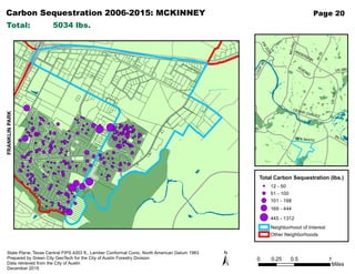
  • 29. Carbon Sequestration 2006-2015: MCKINNEY IH35 US183 MO-PAC LOOP360 BEN WHITE FM 2222 US 290 SH 71 CESAR CHAVEZ KOENIG ANDERSON Page 20 Total Carbon Sequestration (lbs.) 12 - 50 51 - 100 101 - 168 169 - 444 445 - 1312 Neighborhood of Interest Other Neighborhoods ± State Plane, Texas Central FIPS 4203 ft., Lamber Conformal Conic, North American Datum 1983 Prepared by Green City GeoTech for the City of Austin Forestry Division Data retrieved from the City of Austin December 2015 FRANKLINPARK Total: 5034 lbs. 0 0.5 10.25 Miles
  • 30. Carbon Sequestration 2006-2015: MONTOPOLIS IH35 US183 MO-PAC LOOP360 BEN WHITE FM 2222 US 290 SH 71 CESAR CHAVEZ KOENIG ANDERSON Page 21 Total Carbon Sequestration (lbs.) 12 - 50 51 - 100 101 - 168 169 - 444 445 - 1312 Neighborhood of Interest Other Neighborhoods ± State Plane, Texas Central FIPS 4203 ft., Lamber Conformal Conic, North American Datum 1983 Prepared by Green City GeoTech for the City of Austin Forestry Division Data retrieved from the City of Austin December 2015 Total: 25152 lbs. 0 0.45 0.90.225 Miles
  • 31. Carbon Sequestration 2006-2015: N AUSTIN CIVIC ASSOCIATION IH35 US183 MO-PAC LOOP360 BEN WHITE FM 2222 US 290 SH 71 CESAR CHAVEZ KOENIG ANDERSON Page 22 Total Carbon Sequestration (lbs.) 12 - 50 51 - 100 101 - 168 169 - 444 445 - 1312 Neighborhood of Interest Other Neighborhoods ± State Plane, Texas Central FIPS 4203 ft., Lamber Conformal Conic, North American Datum 1983 Prepared by Green City GeoTech for the City of Austin Forestry Division Data retrieved from the City of Austin December 2015 WOOTEN Total: 10620 lbs. 0 0.6 1.20.3 Miles
  • 32. Carbon Sequestration 2006-2015: OLD WEST AUSTIN IH35 US183 MO-PAC LOOP360 BEN WHITE FM 2222 US 290 SH 71 CESAR CHAVEZ KOENIG ANDERSON Page 23 Total Carbon Sequestration (lbs.) 12 - 50 51 - 100 101 - 168 169 - 444 445 - 1312 Neighborhood of Interest Other Neighborhoods ± State Plane, Texas Central FIPS 4203 ft., Lamber Conformal Conic, North American Datum 1983 Prepared by Green City GeoTech for the City of Austin Forestry Division Data retrieved from the City of Austin December 2015 Total: 10152 lbs. 0 0.25 0.50.125 Miles
  • 33. Carbon Sequestration 2006-2015: ROSEWOOD IH35 US183 MO-PAC LOOP360 BEN WHITE FM 2222 US 290 SH 71 CESAR CHAVEZ KOENIG ANDERSON Page 24 Total Carbon Sequestration (lbs.) 12 - 50 51 - 100 101 - 168 169 - 444 445 - 1312 Neighborhood of Interest Other Neighborhoods ± State Plane, Texas Central FIPS 4203 ft., Lamber Conformal Conic, North American Datum 1983 Prepared by Green City GeoTech for the City of Austin Forestry Division Data retrieved from the City of Austin December 2015 Total: 14448 lbs. 0 0.3 0.60.15 Miles
  • 34. Carbon Sequestration 2006-2015: ST. JOHN IH35 US183 MO-PAC LOOP360 BEN WHITE FM 2222 US 290 SH 71 CESAR CHAVEZ KOENIG ANDERSON Page 25 Total Carbon Sequestration (lbs.) 12 - 50 51 - 100 101 - 168 169 - 444 445 - 1312 Neighborhood of Interest Other Neighborhoods ± State Plane, Texas Central FIPS 4203 ft., Lamber Conformal Conic, North American Datum 1983 Prepared by Green City GeoTech for the City of Austin Forestry Division Data retrieved from the City of Austin December 2015 CORONADOHILLS Total: 2016 lbs. 0 0.3 0.60.15 Miles
  • 35. Carbon Sequestration 2006-2015: SWEETBRIAR IH35 US183 MO-PAC LOOP360 BEN WHITE FM 2222 US 290 SH 71 CESAR CHAVEZ KOENIG ANDERSON Page 26 Total Carbon Sequestration (lbs.) 12 - 50 51 - 100 101 - 168 169 - 444 445 - 1312 Neighborhood of Interest Other Neighborhoods ± State Plane, Texas Central FIPS 4203 ft., Lamber Conformal Conic, North American Datum 1983 Prepared by Green City GeoTech for the City of Austin Forestry Division Data retrieved from the City of Austin December 2015 WEST CONGRESS EASTCONGRESS Total: 9982 lbs. 0 0.25 0.50.125 Miles
  • 36. Carbon Sequestration 2006-2015: WEST CONGRESS IH35 US183 MO-PAC LOOP360 BEN WHITE FM 2222 US 290 SH 71 CESAR CHAVEZ KOENIG ANDERSON Page 27 Total Carbon Sequestration (lbs.) 12 - 50 51 - 100 101 - 168 169 - 444 445 - 1312 Neighborhood of Interest Other Neighborhoods ± State Plane, Texas Central FIPS 4203 ft., Lamber Conformal Conic, North American Datum 1983 Prepared by Green City GeoTech for the City of Austin Forestry Division Data retrieved from the City of Austin December 2015 EAST CONGRESS EASTCONGRESS Total: 16842 lbs. 0 0.3 0.60.15 Miles
  • 37. Carbon Sequestration 2006-2015: WOOTEN IH35 US183 MO-PAC LOOP360 BEN WHITE FM 2222 US 290 SH 71 CESAR CHAVEZ KOENIG ANDERSON Page 28 Total Carbon Sequestration (lbs.) 12 - 50 51 - 100 101 - 168 169 - 444 445 - 1312 Neighborhood of Interest Other Neighborhoods ± State Plane, Texas Central FIPS 4203 ft., Lamber Conformal Conic, North American Datum 1983 Prepared by Green City GeoTech for the City of Austin Forestry Division Data retrieved from the City of Austin December 2015 N AUSTIN CIVIC ASSOCIATION CRESTVIEW NAUSTINCIVICASSOCIATION Total: 9020 lbs. 0 0.35 0.70.175 Miles
  • 38. Energy Conservation 2006-2015: CORONADO HILLS IH35 US183 MO-PAC LOOP360 BEN WHITE FM 2222 US 290 SH 71 CESAR CHAVEZ KOENIG ANDERSON Page 29 Total Energy Conserved (kWh) 2 - 18 19 - 36 37 - 64 65 - 183 184 - 630 Neighborhood of Interest Other Neighborhoods ± State Plane, Texas Central FIPS 4203 ft., Lamber Conformal Conic, North American Datum 1983 Prepared by Green City GeoTech for the City of Austin Forestry Division Data retrieved from the City of Austin December 2015 ST.JOHN Total: 8696 kWh 0 0.2 0.40.1 Miles
  • 39. Energy Conservation 2006-2015: CRESTVIEW IH35 US183 MO-PAC LOOP360 BEN WHITE FM 2222 US 290 SH 71 CESAR CHAVEZ KOENIG ANDERSON Page 30 Total Energy Conserved (kWh) 2 - 18 19 - 36 37 - 64 65 - 183 184 - 630 Neighborhood of Interest Other Neighborhoods ± State Plane, Texas Central FIPS 4203 ft., Lamber Conformal Conic, North American Datum 1983 Prepared by Green City GeoTech for the City of Austin Forestry Division Data retrieved from the City of Austin December 2015 WOOTEN Total: 27540 kWh 0 0.25 0.50.125 Miles
  • 40. Energy Conservation 2006-2015: EAST CESAR CHAVEZ IH35 US183 MO-PAC LOOP360 BEN WHITE FM 2222 US 290 SH 71 CESAR CHAVEZ KOENIG ANDERSON Page 31 Total Energy Conserved (kWh) 2 - 18 19 - 36 37 - 64 65 - 183 184 - 630 Neighborhood of Interest Other Neighborhoods ± State Plane, Texas Central FIPS 4203 ft., Lamber Conformal Conic, North American Datum 1983 Prepared by Green City GeoTech for the City of Austin Forestry Division Data retrieved from the City of Austin December 2015 Total: 7580 kWh 0 0.25 0.50.125 Miles
  • 41. Energy Conservation 2006-2015: EAST CONGRESS IH35 US183 MO-PAC LOOP360 BEN WHITE FM 2222 US 290 SH 71 CESAR CHAVEZ KOENIG ANDERSON Page 32 Total Energy Conserved (kWh) 2 - 18 19 - 36 37 - 64 65 - 183 184 - 630 Neighborhood of Interest Other Neighborhoods ± State Plane, Texas Central FIPS 4203 ft., Lamber Conformal Conic, North American Datum 1983 Prepared by Green City GeoTech for the City of Austin Forestry Division Data retrieved from the City of Austin December 2015 FRANKLIN PARK FRANKLINPARK WESTCONGRESS Total: 14130 kWh 0 0.35 0.70.175 Miles
  • 42. Energy Conservation 2006-2015: FRANKLIN PARK IH35 US183 MO-PAC LOOP360 BEN WHITE FM 2222 US 290 SH 71 CESAR CHAVEZ KOENIG ANDERSON Page 33 Total Energy Conserved (kWh) 2 - 18 19 - 36 37 - 64 65 - 183 184 - 630 Neighborhood of Interest Other Neighborhoods ± State Plane, Texas Central FIPS 4203 ft., Lamber Conformal Conic, North American Datum 1983 Prepared by Green City GeoTech for the City of Austin Forestry Division Data retrieved from the City of Austin December 2015 MCKINNEY MCKINNEY Total: 10890 kWh 0 0.45 0.90.225 Miles
  • 43. Energy Conservation 2006-2015: MCKINNEY IH35 US183 MO-PAC LOOP360 BEN WHITE FM 2222 US 290 SH 71 CESAR CHAVEZ KOENIG ANDERSON Page 34 Total Energy Conserved (kWh) 2 - 18 19 - 36 37 - 64 65 - 183 184 - 630 Neighborhood of Interest Other Neighborhoods ± State Plane, Texas Central FIPS 4203 ft., Lamber Conformal Conic, North American Datum 1983 Prepared by Green City GeoTech for the City of Austin Forestry Division Data retrieved from the City of Austin December 2015 FRANKLINPARK Total: 5034 kWh 0 0.5 10.25 Miles
  • 44. Energy Conservation 2006-2015: MONTOPOLIS IH35 US183 MO-PAC LOOP360 BEN WHITE FM 2222 US 290 SH 71 CESAR CHAVEZ KOENIG ANDERSON Page 35 Total Energy Conserved (kWh) 2 - 18 19 - 36 37 - 64 65 - 183 184 - 630 Neighborhood of Interest Other Neighborhoods ± State Plane, Texas Central FIPS 4203 ft., Lamber Conformal Conic, North American Datum 1983 Prepared by Green City GeoTech for the City of Austin Forestry Division Data retrieved from the City of Austin December 2015 Total: 25152 kWh 0 0.45 0.90.225 Miles
  • 45. Energy Conservation 2006-2015: N AUSTIN CIVIC ASSOCIATION IH35 US183 MO-PAC LOOP360 BEN WHITE FM 2222 US 290 SH 71 CESAR CHAVEZ KOENIG ANDERSON Page 36 Total Energy Conserved (kWh) 2 - 18 19 - 36 37 - 64 65 - 183 184 - 630 Neighborhood of Interest Other Neighborhoods ± State Plane, Texas Central FIPS 4203 ft., Lamber Conformal Conic, North American Datum 1983 Prepared by Green City GeoTech for the City of Austin Forestry Division Data retrieved from the City of Austin December 2015 WOOTEN Total: 10620 kWh 0 0.6 1.20.3 Miles
  • 46. Energy Conservation 2006-2015: OLD WEST AUSTIN IH35 US183 MO-PAC LOOP360 BEN WHITE FM 2222 US 290 SH 71 CESAR CHAVEZ KOENIG ANDERSON Page 37 Total Energy Conserved (kWh) 2 - 18 19 - 36 37 - 64 65 - 183 184 - 630 Neighborhood of Interest Other Neighborhoods ± State Plane, Texas Central FIPS 4203 ft., Lamber Conformal Conic, North American Datum 1983 Prepared by Green City GeoTech for the City of Austin Forestry Division Data retrieved from the City of Austin December 2015 Total: 10152 kWh 0 0.25 0.50.125 Miles
  • 47. Energy Conservation 2006-2015: ROSEWOOD IH35 US183 MO-PAC LOOP360 BEN WHITE FM 2222 US 290 SH 71 CESAR CHAVEZ KOENIG ANDERSON Page 38 Total Energy Conserved (kWh) 2 - 18 19 - 36 37 - 64 65 - 183 184 - 630 Neighborhood of Interest Other Neighborhoods ± State Plane, Texas Central FIPS 4203 ft., Lamber Conformal Conic, North American Datum 1983 Prepared by Green City GeoTech for the City of Austin Forestry Division Data retrieved from the City of Austin December 2015 Total: 14448 kWh 0 0.3 0.60.15 Miles
  • 48. Energy Conservation 2006-2015: ST. JOHN IH35 US183 MO-PAC LOOP360 BEN WHITE FM 2222 US 290 SH 71 CESAR CHAVEZ KOENIG ANDERSON Page 39 Total Energy Conserved (kWh) 2 - 18 19 - 36 37 - 64 65 - 183 184 - 630 Neighborhood of Interest Other Neighborhoods ± State Plane, Texas Central FIPS 4203 ft., Lamber Conformal Conic, North American Datum 1983 Prepared by Green City GeoTech for the City of Austin Forestry Division Data retrieved from the City of Austin December 2015 CORONADOHILLS Total: 2016 kWh 0 0.3 0.60.15 Miles
  • 49. Energy Conservation 2006-2015: SWEETBRIAR IH35 US183 MO-PAC LOOP360 BEN WHITE FM 2222 US 290 SH 71 CESAR CHAVEZ KOENIG ANDERSON Page 40 Total Energy Conserved (kWh) 2 - 18 19 - 36 37 - 64 65 - 183 184 - 630 Neighborhood of Interest Other Neighborhoods ± State Plane, Texas Central FIPS 4203 ft., Lamber Conformal Conic, North American Datum 1983 Prepared by Green City GeoTech for the City of Austin Forestry Division Data retrieved from the City of Austin December 2015 WEST CONGRESS EASTCONGRESS Total: 9982 kWh 0 0.25 0.50.125 Miles
  • 50. Energy Conservation 2006-2015: WEST CONGRESS IH35 US183 MO-PAC LOOP360 BEN WHITE FM 2222 US 290 SH 71 CESAR CHAVEZ KOENIG ANDERSON Page 41 Total Energy Conserved (kWh) 2 - 18 19 - 36 37 - 64 65 - 183 184 - 630 Neighborhood of Interest Other Neighborhoods ± State Plane, Texas Central FIPS 4203 ft., Lamber Conformal Conic, North American Datum 1983 Prepared by Green City GeoTech for the City of Austin Forestry Division Data retrieved from the City of Austin December 2015 EAST CONGRESS EASTCONGRESS Total: 16842 kWh 0 0.3 0.60.15 Miles
  • 51. Energy Conservation 2006-2015: WOOTEN IH35 US183 MO-PAC LOOP360 BEN WHITE FM 2222 US 290 SH 71 CESAR CHAVEZ KOENIG ANDERSON Page 42 Total Energy Conserved (kWh) 2 - 18 19 - 36 37 - 64 65 - 183 184 - 630 Neighborhood of Interest Other Neighborhoods ± State Plane, Texas Central FIPS 4203 ft., Lamber Conformal Conic, North American Datum 1983 Prepared by Green City GeoTech for the City of Austin Forestry Division Data retrieved from the City of Austin December 2015 N AUSTIN CIVIC ASSOCIATION CRESTVIEW NAUSTINCIVICASSOCIATION Total: 9020 kWh 0 0.35 0.70.175 Miles