GDACS Virtual OSOCC
Download as PPTX, PDF2 likes507 views

The document discusses GDACS and the Virtual OSOCC. GDACS is a disaster monitoring and alert system that collects hazard data and issues color-coded alerts. It also includes the Virtual OSOCC, an online coordination platform. The Virtual OSOCC allows responders to exchange information during disasters. It supports coordination and situational awareness in the early stages of sudden-onset disasters. The document provides details on the tools and services provided by GDACS and guidelines for how different responders should use the Virtual OSOCC.


GDACS Virtual OSOCC
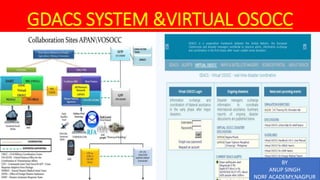
- 1. GDACS SYSTEM &VIRTUAL OSOCC BY ANUP SINGH NDRF ACADEMY,NAGPUR
- 2. AGENDA POINTS FOR THIS LECTURE ARE • GDACS SYSTEM • VIRTUAL OSOCC • PURPOSE ,FUNTION AND FACILITIES
- 3. GLOBAL DISASTER ALERT AND COORDINATION SYSTEM • The Global Disaster Alert and Coordination System (GDACS) was created as a cooperation framework between the United Nations and the European Commission in 2004, in order to address significant gaps in information collection and analysis in the early phase of major sudden-onset disasters. • It was created to reduce the various monitor websites for the different disaster types. • It is a multi-hazard disaster monitor and alert system for earthquakes, tsunamis, floods, volcanoes, and tropical cyclones. • It started as GDAS, but was later coupled with the coordination information system of OCHA (the OCHA Virtual OSOCC). • In 2004, the Virtual OSOCC was integrated into the Global Disaster Alert and Coordination System (GDCAS) as GDACS’ online coordination platform for first (bilateral) disaster responders. • GDACS collects near real-time hazard information and combines this with demographic and socio-economic data to perform a mathematical analysis of the expected impact. • The result of this risk analysis is distributed by the GDACS website and alerts are sent via email, fax, and SMS to subscribers in the disaster relief community, and all other persons that are interested in this information.
- 6. GDACS - DEVELOPS DATA TOOLS AND SERVICES FOR; International Search and Rescue Advisory Group (INSARAG) Guidelines UN Disaster Assessment and Coordination (UNDAC) Field Handbook International Federation of Red Cross and Red Crescent Societies (IFRC) Publications Standard Operating Procedures from the European Community Mechanism for Civil Protection International Humanitarian Partnership (IHP) Euro Atlantic Disaster Response Coordination Centre (EADRCC)
- 7. GDACS TOOLS AND SERVICES GDACS offers the following information: – Disasters alerts and impact estimations after major disasters – The Virtual On-Site Operations Coordination Center (OSOCC) – Maps and Satellite Imagery – A Science portal
- 8. GDACS DISASTER ALERTS Floods – Inundation – Deaths – Displacement Tropical Cyclones – Winds – Heavy rain – Storm surge Earthquake and Tsunamis – Intensity and magnitude – Hypocenter depth – Population within 100 km from the epicenter – Vulnerability of the affected countries
- 9. COLOUR CODED ALERTS 1. Green: unlikely to be a disaster requiring international assistance, although it can be a local disaster 2. Orange: can be a disaster requiring international assistance 3. Red: most likely a catastrophic event, requiring international assistance • Note that lower levels include higher levels. If you register for Green alerts, you will also receive Orange and Red alerts. • Quiet Night option: it is possible to queue alerts sent at night (in your time zone set in the previous step) until 06:00 the following day
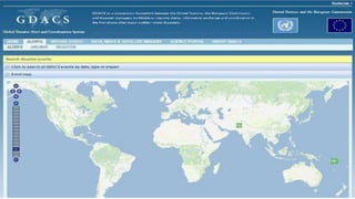
- 10. GDACS - VIRTUAL ON-SITE OPERATIONS COORDINATION CENTER • Real-time disaster information system portal • User account required • Disaster managers exchange information • Summary reports of on-going disaster reports posted
- 11. iGDACS - mobile app • Allows you to get the latest GDACS alerts and key statistics right on your iphone or ipad. • In addition, it allows you to provide feedback on GDACS events, which is - after moderation - communicated to the GDACS community (http://i.Gdacs.Org). • This is available for all GDACS alerts, including green alerts.
- 12. VIRTUAL OSOCC (VOSOCC) • The Virtual OSOCC (VOSOCC) is a real-time online coordination platform that allows information exchange early in an emergency. • Specific features of the VOSOCC allow responders to exchange information such as baseline country information (including relevant socio-economic and demographic information), entry points and other logistical aspects, relief team status, assessment information, cluster activities, civil-military coordination arrangements, environmental risks and security. • User community Access to Virtual OSOCC is restricted to disaster managers from governments and disaster response organizations – Registration is required. • The activation of Virtual OSOCC in case of an earthquake is usually triggered by a Red GDACS alert.
- 13. Virtual On-Site Operations Coordination Centre (VO) • All Virtual OSOCC users have the opportunity to create E-mail and SMS messages that are sent automatically to subscribers to inform about critical situation updates during disaster response operations. • Through the Virtual OSOCC the United Nations Assessment and Coordination Team (UNDAC) can be mobilized effectively through on- line workflow procedures including SMS and E-mail. • Virtual OSOCC provides its users with a discussion forum for any area of interest, including information exchange on best practice and lessons-learned after disaster response operations. • Virtual OSOCC includes a photo library where users can share disaster and other related photos as documentation or presentation material or souvenir of a joint mission.
- 16. USE OF THE VIRTUAL OSOCC - DISASTER-AFFECTED COUNTRY The following information would be expected from the national authorities following a major sudden- onset disaster: Clarify the need for international assistance. The sooner the modalities of international assistance (requested, welcome, not required, etc.) are posted on the Virtual OSOCC, the better and more adequately the international community will react. A brief description of the disaster management and/or coordination set-up within the government, and contact details of relevant focal points. Information about the situation in the disaster-affected areas, including access of the affected areas and related constraints. Priority needs and operational priorities - which type of relief is most needed (search and rescue, water, food, shelter, fuel, air transport, etc.) and in which geographic areas. Customs and immigration - contact details of national and/or local customs focal points, procedures relating to immigration of relief workers and equipment, and additional information to allow responders to adequately prepare. Urgent announcements and/or key information updates, as needed.
- 17. USE OF THE VIRTUAL OSOCC - RESPONDERS To support information analysis and decision making, international responders should provide information on the Virtual OSOCC reliably and timely in the following areas: Updates on planned or mobilised relief teams and experts, description of type and capacity, estimated arrival, transport or other support requirements in the field. Information about planned or mobilised in-kind contributions, such as relief or medical items, but not cash, along with description of type and capacity, estimated arrival, and indication of consignee to take over at the arrival point in the affected country and manage the distribution. Updates about established coordination structures at regional or field level by the own country or organization. Examples of such structures include military command posts, preliminary Reception/Departure Centre (RDC) and OSOCC and information centres at embassies. Any available and recent information about the situation in the affected areas and additional needs and gaps identified. Maps, satellite images, situation and assessment reports.
- 19. WHAT DOES THE VIRTUAL OSOCC OFFER TO USAR TEAMS? For international USAR teams which are about to deploy to the affected areas, the Virtual OSOCC provides a one-stop-shop for information about the operational environment in the field: Basic country information Operational priorities The rules and regulations for equipment entry and visas Security situation Logistical constraints Available and working communications systems The location and contacts of the OSOCC RDC and other relief teams etc. During operations in the field, USAR teams use the Virtual OSOCC for information exchange and coordination.
- 20. WHAT ARE USAR TEAMS EXPECTED TO POST, WHEN AND WHERE? 1. As per the INSARAG Guidelines, all international USAR teams need to register prior to their deployment, indicating their status in the response (monitoring, stand-by, mobilizing, deployed or stand-down). This information will be used by the OSOCC and national authorities to prepare for and coordinate the response. If the USAR team is ready to deploy (i.e. changing its status to mobilizing) it needs to fill out the fact sheet, providing contact details, capacity and arrival times. USAR teams need to change their team status when the situation requires doing so. 2. USAR teams are expected to keep abreast of the latest information from the ground and of any instructions from LEMA or OCHA provided on the Virtual OSOCC. In case of questions or a need for clarifications, teams should post a question in the comments section of the relevant discussion title.
- 21. 3. If the USAR team is the first to arrive in the affected areas and establishes a provisional OSOCC or RDC, it needs to provide location, contact details and any other relevant information as a comment in the ‘Response coordination’ title. • Discussion moderators will move information to the relevant subtitles. 4. During the operations phase, information about the field coordination (discussion between USAR teams, exchange of situation reports and information sharing) should be exchanged under the USAR coordination subtitle. • If the operational are is divided into sectors by the OSOCC, discussion moderators will create relevant subtitles, eg. USAR Sector 1, USAR Sector 2 WHAT ARE USAR TEAMS EXPECTED TO POST, WHEN AND WHERE?
- 22. VIRTUAL OSOCC GUIDELINES Virtual OSOCC Handbook Vol I: User Manual Virtual OSOCC for UNDAC teams Virtual OSOCC for USAR teams Virtual OSOCC for Foreign Medical Teams OSOCC Virtual manual del usuario GDACS Guidelines 2014 OSOCC Guidelines - Position checklist OSOCC Guidelines - Operations Cycle OSOCC Guidelines - Org Chart OSOCC Guidelines - RDC Layout OSOCC Guidelines - OSOCC setup OSOCC Guidelines - Site Selection OSOCC Guidelines - USAR Planning Tool OSOCC Guidelines - Forms Guías OSOCC - En Español UN-CMCoord Field Handbook
- 23. THANKS
- 24. GDACS - DISASTER INFORMATION SYSTEMS AND ONLINE COORDINATION TOOLS 1 . GDACS Disaster Alerts, which are issued and disseminated to some 25,000 subscribers immediately following sudden-onset disasters. The automatic estimates and risk analysis – the basis of the alerts are provided by the European Commission Joint Research Centre (JRC) and the Global Flood Observatory. 2. The Virtual OSOCC – a password-restricted online platform for real-time information exchange and cooperation among all actors in the first phase of the disaster. Information updates from the affected country and international responders are moderated by a dedicated team. The Virtual OSOCC is managed by the (UN OCHA).
- 25. • 3. Maps and satellite imagery from various providers, including UNOSAT and Map Action, are shared on the Virtual OSOCC. • The GDACS Satellite Mapping and Coordination System (SMCS) provides a communication and coordination platform where organisations may monitor and inform stakeholders of their completed, current and future mapping activities during emergencies. • This service is facilitated by the United Nations Institute for Training and Research (UNITAR) Operational Satellite Applications Programme (UNOSAT). • 4. A Science Portal dedicated to several scientific communities with special interests and a number of Expert Working Groups; the Portal is managed by European Commission Joint Research Centre (JRC) . GDACS - DISASTER INFORMATION SYSTEMS AND ONLINE COORDINATION TOOLS
- 26. GDACS SCIENCE PORTAL • Natural hazards: earthquakes, tsunamis, cyclones, floods and volcanoes • Crisis response and management technology • Geospatial infrastructure and modelling • Social media for crisis management • The portal provides dedicated discussion spaces for expert working groups and hosts experimental systems that are candidates for further integration in GDACS
- 27. GDACS TOOLS AND SERVICES GDACS offers the following information via its websites: Disasters alerts and impact estimations after major disasters through a multi-hazard disaster impact assessment service managed by the European Commission Joint Research Centre (JRC) The Virtual On-Site Operations Coordination Center (VOSOCC), a password-restricted site managed by the United Nations Office for the Coordination of Humanitarian Affairs (OCHA) Maps and Satellite Imagery A Science portal
- 28. GDACS TOOLS AND SERVICES GDACS offers the following information: – Disasters alerts and impact estimations after major disasters – The Virtual On-Site Operations Coordination Center (OSOCC) – Maps and Satellite Imagery – A Science portal
- 29. PURPOSE AND SCOPE • The primary purpose of Virtual OSOCC is to facilitate information exchange among disaster responders in order to establish a better situational awareness in the early stages of sudden-onset disasters, to inform deploying responders of the operational environment, and to track response to support decision-making and coordination. • The Virtual OSOCC supports preparedness activities, including meetings, training events, expert discussion fora, and simulation exercises. • The Virtual OSOCC is activated in major sudden-onset disasters and supports international coordination during the first weeks of the response.
Editor's Notes
- #4: The Virtual OSOCC was launched to facilitate information exchange among the UNDAC team and INSARAG USAR teams in earthquakes Since then, the tool has evolved into an important information platform for the international disaster response community, which is used to facilitate information exchange not only in earthquakes, but also in all major sudden-onset emergencies as well as during preparedness activities such as training events, simulation exercises, meetings and expert discussion fora. In 2004, the Virtual OSOCC was integrated into the Global Disaster Alert and Coordination System (GDCAS) as GDACS’ online coordination platform for first (bilateral) disaster responders. GDACS is a cooperation framework among OCHA, the European Commission, UNOSAT, and disaster managers worldwide, which provides automatic alerts, impact estimations, and an on-line coordination platform for disaster managers and producers of satellite-images and maps. Global Disaster Alert and Coordination System Virtual OSOCC is an OCHA-managed GDACS tool. GDACS is a cooperation framework under the UN umbrella that brings together disaster information systems and disaster managers worldwide with the aim of filling the information and coordination gap in the first phase after major disasters. GDACS provides real-time access to web-based disaster information systems and related coordination tools. GDACS sends automatic e-mail and SMS alerts to subscribers and provides impact estimations after major disasters through its on-line multi-hazard disaster impact assessment service. GDACS alerts and impact estimations are managed by the European Commission Joint Research Centre. GDACS also coordinates the creation and dissemination of disaster maps and satellite images. This service is managed by UNOSAT. Many governments and disaster response organizations rely on GDACS alerts and automatic impact estimations to plan international assistance.
- #5: User community Access to Virtual OSOCC is restricted to disaster managers from governments and disaster response organizations. The platform was initially designed as a tool for bilateral responders; however, over the years increasing numbers of staff from UN agencies and NGOs have created accounts. Users have one of the following privileges with regard to the system: 1. Guest: Read only 2. User: (default for new users): Access to discussion information, provide comments, and upload files 3. Moderator: Add and edit all information in a discussion 4. Account manager: Create user accounts and manage account requests 5. Workspace administrator: Configuration and data management of a given workspace 6. System administrator: Overall system configuration and data management Some users are authorized to post information on behalf of their county or organization, and yet others can also edit information posted on behalf of their country or information. If you have any inquiries regarding user privileges, please contact us at virtual-osocc@un.org.
- #7: GDACS is guided by a Steering Committee and holds annual stakeholder meetings to bring together disaster managers, scientists, GIS and web developers, as well as other experts, in order to define standards for information exchange and strategy for the future development of GDACS services. OCHA’s Activation and Coordination Support Unit (ACSU) serves as the GDACS Secretariat.
- #10: GDACS alerts provide automated early warning and preliminary impact estimates on natural disasters around the world. Its alerts are primarily aimed at the international humanitarian community and reflect the possibility of a need for international assistance. Four types of alerts can be issued: indicate minor event, were the need for international assistance is very unlikely. GREEN ALERTS indicate moderate events, where the need for international is not likely. ORANGE ALERTS indicate potential local disasters, where international assistance might be required. RED ALERTS indicate potentially severe disasters, where international assistance is expected to be required. Currently GDACS alerts are issued for earthquakes and possible subsequent tsunamis, tropical cyclones and floods. Studies are under way to include volcanic eruptions in this list.
- #13: The Virtual OSOCC (VOSOCC) is a real-time online coordination platform that allows information exchange early in an emergency. It is a component of the Global Disaster Alert and Coordination System (GDACS), a cooperative framework supported by OCHA Geneva. Specific features of the VOSOCC allow responders to exchange information such as baseline country information (including relevant socio-economic and demographic information), entry points and other logistical aspects, relief team status, assessment information, cluster activities, civil-military coordination arrangements, environmental risks and security. In addition to emergencies, the VOSOCC supports training coordination, information sharing and project discussions. User community Access to Virtual OSOCC is restricted to disaster managers from governments and disaster response organizations – registration is required. The VO is managed by the Activation and Coordination Support Unit at OCHA in Geneva. Virtual OSOCC is a real-time online coordination tool for disaster response professionals from USAR teams, national authorities, as well as regional and international organizations at a global level. The activation of Virtual OSOCC in case of an earthquake is usually triggered by a Red GDACS alert. Virtual OSOCC facilitates decision-making for international response to major disasters though real-time information exchange by all actors of the international disaster response community. All Virtual OSOCC users have the opportunity to create e-mail and sms messages that are sent automatically to subscribers to inform about critical situation updates during disaster response operations. Through the Virtual OSOCC the United Nations Assessment and Coordination Team (UNDAC) can be mobilised effectively through on-line workflow procedures including sms and e-mail. Virtual OSOCC facilitates management of UNDAC, INSARAG and UN-CMCoord training, meetings and workshops through e-mail notification, on-line participant registration and discussion of background material. Virtual OSOCC provides its users with a discussion forum for any area of interest, including information exchange on best practice and lessons-learned after disaster response operations. Virtual OSOCC includes a photo library where users can share disaster and other related photos as documentation or presentation material or souvenir of a joint mission.
- #15: GDACS Satellite Mapping Coordinate System (SMCS) Led by UNITAR-UNOSAT Includes NASA and ESA satellite data A GIS-based tool of satellite imagery for specific disaster events – requires user registration Provides past and real-time imagery for an event Also offers: – Baseline maps – Situation specific maps – Damage assessment maps – Weather forecast maps
- #17: Local and national authorities are encouraged to contribute to disaster discussions with information about the scale and extension of the disaster, the need for international assistance, identified priority needs, government focal points, and instructions for international responders. Active participation of the affected country in the Virtual OSOCC disaster discussions usually helps responding countries to plan their response more adequately and efficiently. Especially in earthquakes, the Virtual OSOCC has proven effective in supporting operational planning of the search and rescue operations, as national authorities are timely informed about deploying teams, their arrival details, logistics requirements, and capacity. The following information would be expected from the national authorities following a major sudden-onset disaster: Clarify the need for international assistance. The sooner the modalities of international assistance (requested, welcome, not required, etc.) are posted on the Virtual OSOCC, the better and more adequately the international community will react. A brief description of the disaster management and/or coordination set-up within the government, and contact details of relevant focal points. Information about the situation in the disaster-affected areas, including access of the affected areas and related constraints. Priority needs and operational priorities - which type of relief is most needed (search and rescue, water, food, shelter, fuel, air transport, etc.) and in which geographic areas. Customs and immigration - contact details of national and/or local customs focal points, procedures relating to immigration of relief workers and equipment, and additional information to allow responders to adequately prepare. Urgent announcements and/or key information updates, as needed.
- #18: To support information analysis and decision making, international responders should provide information on the Virtual OSOCC reliably and timely in the following areas: Updates on planned or mobilised relief teams and experts, along with description of type and capacity, estimated arrival, and eventual transport or other support requirements in the field. Information about planned or mobilised in-kind contributions, such as relief or medical items, but not cash, along with description of type and capacity, estimated arrival, and indication of consignee to take over at the arrival point in the affected country and manage the distribution. Updates about established coordination structures at regional or field level by the own country or organization. Examples of such structures include military command posts, preliminary Reception/Departure Centre (RDC) and OSOCC and information centres at embassies. Any available and recent information about the situation in the affected areas and additional needs and gaps identified. Maps, satellite images, situation and assessment reports.
- #20: USAR teams have access to information and announcements from the UNDAC team, the OSOCC or LEMA, but they also have a space for discussion and sharing of situation reports.
- #21: The amount of information entered on the Virtual OSOCC during large-scale emergencies can quickly become overwhelming. Before posting a comment, always consider carefully of the information is necessary. For example, after the team status has been updated in the team fact sheet, there is no need to provide the same information as a comment. Comments and/or files should be posted under the appropriate subtitle. Alternatively, generic situation updates about the disaster should be posted under subtitle “Situation overview”. This will help other users to find relevant information more efficiently.
- #25: The Global Disaster Alert and Coordination System (GDACS) was created as a cooperation framework between the United Nations and the European Commission in 2004, in order to address significant gaps in information collection and analysis in the early phase of major sudden-onset disasters. For the past decade, GDACS has drawn on the collective capacity of disaster managers and information systems worldwide to facilitate international information exchange and decision-making. GDACS offers the following information via its websites: Disasters alerts and impact estimations after major disasters through a multi-hazard disaster impact assessment service managed by the European Commission Joint Research Centre (JRC) The Virtual On-Site Operations Coordination Center (VOSOCC), a password-restricted site managed by the United Nations Office for the Coordination of Humanitarian Affairs (OCHA) Maps and Satellite Imagery A Science portal