Intergraph’s Server Offering
Richard Goodman
Intergraph (UK) Ltd

SMARTERDECISIONS
Geospatial Enterprise Portfolio
Driving Smarter Decisions

WORKFLOW

ORGANISE
& MANAGE

SECURITY

ENTERPRISE
WORKFLOW,
DATA & USER
MANAGEMENT

DELIVER
GEOPROCESSING
& GEOSERVICES

CONTENT

Web
Mobile
Desktop
Server

IMAGE EXPLOITATION, RS, Photogrammetry

GIS DATA PRODUCTION & USE

USE

WEB CAPTURE, EDIT, ANALYSIS, etc.

© 2012 Intergraph Corporation
Geospatial - Server

8/29/2013

©2012 Intergraph Corporation

3
Geospatial - Server

GeoMedia

IMAGINE
LPS

ImageStation

Smart
Client

Browser
Client

Mobile
Client

Server
Delivery Service

Discovery Service

Data Mgmt Service

Enterprise Services

Security & Administration
Geospatial Portal

Smart Client
Geospatial Server

WebMap

Enterprise database
8/29/2013

APOLLO

Other data & services

Catalog &
Metadata

©2012 Intergraph Corporation

File based data
(raster, vector, point
clouds, motion video, …)

4
Unified Admin Console

•

Create and configure all aspects of server side engines,
web services and web applications in one place

Create

© 2013 Intergraph Corporation

5
Unified Admin Console

Configure

© 2013 Intergraph Corporation

6
Dynamic publishing

• Easily build and deploy web services and websites
• Visualization, edit, and analysis valuable geographic
information
• Fully scalable server solution

GeoMedia
WebMap
Publisher
Metadata

© 2013 Intergraph Corporation

7
Unified Client

• Based on Geospatial Portal
− Provides a much-more services-oriented web client

• Still use GeoMedia as your visual-authoring environment
• Easily create an application based on a GeoMedia
GeoWorkspace

© 2013 Intergraph Corporation

8
Dynamic Label Generation

• With a powerful, fast, and sophisticated rules-based
labeling system

© 2013 Intergraph Corporation

9
Dynamic Label Generation

• With a powerful, fast, and sophisticated rules-based
labeling system

12/02/2013

©2013 Intergraph Corporation

10
Linear Analysis Web Services

• All advanced linear analysis web services can be created
and configured in one place - the new Administration
Console

© 2013 Intergraph Corporation

11
New Web Service Protocols

• New OGC Web Gazetteer Server (WFS-G) operations
standard
− Enable clients of the service to query by place name

• New OGC Web Map Tile Service (OGC WMTS)
− Consume and render WMTS data with new WebMap Publisher
application

© 2013 Intergraph Corporation

12
Unified Imagery Integration

• For superior image delivery into WebMap client
applications, GeoMedia WebMap may be integrated with
ERDAS APOLLO
−

Superior image delivery performance in comparison to any other image
serving solution on the market

© 2013 Intergraph Corporation

13
Unified Geospatial Data Management

• Comprehensive data management, analysis, and delivery
system that enables an organization to crawl, catalog,
describe and securely disseminate massive volumes of
geospatial and business data

© 2013 Intergraph Corporation

14
Unified Geospatial Data Management

•

Improved administration
•
•
•
•

All configuration options can be now done within the GUI
Datasets can be copied, dragged, dropped, and viewed at all times
Define authentication per service
Virtual Mosaic, Geoservices, improved logging, and temporal support all
available in the console

© 2013 Intergraph Corporation

15
Unified Geospatial Data Management

• Group datasets
together, limit by
scale, and portray
potentially
thousands of
datasets as a
single virtual
mosaic layer
• Configure via the
admin console

http://demo.erdas.com.au/virtualmosaic/

© 2013 Intergraph Corporation

16
Unified Geospatial Data Management

• Enable temporal support and enable customers to build
applications to highlight change over time

© 2013 Intergraph Corporation

17
Unified Geospatial Data Management

• Protect intellectual property rights for data by
watermarking

© 2013 Intergraph Corporation

18
Unified Geospatial Data Management

• The existing ESRI ArcXML protocol has been upgraded to
the new ESRI GeoServices Protocol found in the ArcGIS
for Server platform
• This allows ERDAS
APOLLO customers to:
− Serve imagery into ArcGIS
clients natively without
requiring client
redevelopment
− Benefit from ERDAS
APOLLO’s superior
image delivery performance
in comparison to Esri ArcGIS
for Server
An ERDAS APOLLO Essentials dataset being
served by Geoservices into Arcgis.com

© 2013 Intergraph Corporation

19
Unified Geospatial Data Management

•

Automatically relocate and catalog incoming data by
setting up listeners on a ‘drop box’
−

•

Data is moved to target location, and then crawled into catalog

Additional features:
−
−
−

Select any number of directories as drop box
Create filters on data formats
Couple with FTP server to create a remote drop box

© 2013 Intergraph Corporation

20
Unified Geospatial Data Management

• Clip, Zip and Ship subsets of LASformatted point cloud data

• Geospatial SDI
façades
− INSPIRE compliance for
the view services

− Select clip area
− Select classifications
− Filter by return value

− Client-side functionality in
Geospatial Portal

© 2013 Intergraph Corporation

21
Unified Geospatial Data Management

•
•
•

Interoperable and scalable spatial data Infrastructure
Manage and serve secure or licensed information using standards-based
web services
Adheres to OGC, INSPIRE and ISO standards for web services and
metadata compliance

© 2013 Intergraph Corporation

22
Unified Geospatial Data Management

• Catalog Editor is now bundled with Geospatial SDI
− Create, edit, and delete catalog metadata records, individually & enmass

© 2013 Intergraph Corporation

23
Unified Geospatial Client

•
•
•
•

Browse & search the catalog
View data
Consume from APOLLO
web services
Download and CZS datasets
−

•

Load to IMAGINE, Google

Geoprocessing

© 2013 Intergraph Corporation

24
Unified Geospatial Client

• Browser-based web application that acts as a client for spatial data services
• Ready-to-run, browser-based portal enables users to find, view, query, analyze
and consume geospatial data and standard web services delivered by
Intergraph and/or third-party products
• Provides ISO/OGC compliance and works with INSPIRE discovery, view,
download and transformation services

© 2013 Intergraph Corporation

25
Unified Geospatial Client

•

•
•

•

•

Integrated database of
available Coordinate Reference
Systems (CRS)
Easy to use search mechanism
Server-side reprojection when
working with ERDAS APOLLO
or GeoMedia WebMap services
Client-side reprojection of
footprints and other
miscellaneous vector shapes
displayed in the browser
Maintains area of interest
when changing CRS on the
client side
© 2013 Intergraph Corporation

26
Unified Geospatial Client

• Runs on mobile devices
− Automatically displays a simplified interface when viewed with a mobile
device GUI
•
•
•
•

Display, zoom and switch predefined maps
Show feature attributes (GetFeatureInfo)
Center the map based on device localization capabilities (GPS, A-GPS)
On IOS based devices, Geospatial Portal supports pinching for zoom and pan activities

© 2013 Intergraph Corporation

27
Unified Geospatial Client
Questions?

SMARTERDECISIONS
8/29/2013

©2012 Intergraph Corporation

29
Thank You!

http://geospatial.intergraph.com

Geospatial Portfolio 2013

More Related Content

PDF
Academic program - Intergraph U programme
PPTX
GWT 2014: Emergency Conference - 02 le soluzioni geospaziali per la gestione ...
PDF
ADF Data Visualisatie sessie - Introductie DVT componenten
PDF
Introducing the 2013 Geospatial Portfolio_ Alastair Ritchie - Intergraph Geos...
PDF
IMGS 2015 - Transport for London - Alun Pearsey
PDF
Living objects network performance_management_v2
PPTX
TechM GIS Competency
PPTX
IBM SoftLayer Overview - July 2014
Academic program - Intergraph U programme
GWT 2014: Emergency Conference - 02 le soluzioni geospaziali per la gestione ...
ADF Data Visualisatie sessie - Introductie DVT componenten
Introducing the 2013 Geospatial Portfolio_ Alastair Ritchie - Intergraph Geos...
IMGS 2015 - Transport for London - Alun Pearsey
Living objects network performance_management_v2
TechM GIS Competency
IBM SoftLayer Overview - July 2014

Similar to Intergraph’s Server Offering_Richard Goodman - Intergraph Geospatial World Tour 2013 (20)

PPTX
Geospatial Product Watch 2015
PDF
InfoSphere BigInsights
PPTX
GWT 2014: Energy Conference - 02 Le soluzioni Geospaziali per il mondo energy
PDF
What's new in webMethods - Gareth Whitaker - Software AG
PPTX
asasasasasasaasasasasasasasasasasasasas-1.pptx
PDF
GIS Standards and Interoperability
PPTX
An Intro to DI Geodata services
PDF
Citrix Synergy: Opening Keynote with CEO Mark Templeton
PDF
Smart Client Smart Applications_Ciaran Kirk - Intergraph Geospatial World Tou...
PPTX
Softlayer an IBM Compay . Connaissez vous le cloud de l'avenir
PDF
Rethinking the Database in the IoT Era
PPTX
BLM UT Mobile Data Collection
PDF
MongoDB World 2019: Wipro Software Defined Everything Powered by MongoDB
PPTX
Oracle GoldenGate Cloud Service Overview
PPTX
Harnessing the Power of Google Cloud Platform: Strategies and Applications
PPTX
Implementing a Disconnected Mobile Application with DSI for Field Operations
PDF
The Modern Database for Enterprise Applications
PDF
CWIN17 Frankfurt / Cloudera
PPTX
SUGCON NA 2023 - Crafting Lightning Fast Composable Experiences.pptx
PDF
GI2013 ppt vohnout&team-enviro_grids
Geospatial Product Watch 2015
InfoSphere BigInsights
GWT 2014: Energy Conference - 02 Le soluzioni Geospaziali per il mondo energy
What's new in webMethods - Gareth Whitaker - Software AG
asasasasasasaasasasasasasasasasasasasas-1.pptx
GIS Standards and Interoperability
An Intro to DI Geodata services
Citrix Synergy: Opening Keynote with CEO Mark Templeton
Smart Client Smart Applications_Ciaran Kirk - Intergraph Geospatial World Tou...
Softlayer an IBM Compay . Connaissez vous le cloud de l'avenir
Rethinking the Database in the IoT Era
BLM UT Mobile Data Collection
MongoDB World 2019: Wipro Software Defined Everything Powered by MongoDB
Oracle GoldenGate Cloud Service Overview
Harnessing the Power of Google Cloud Platform: Strategies and Applications
Implementing a Disconnected Mobile Application with DSI for Field Operations
The Modern Database for Enterprise Applications
CWIN17 Frankfurt / Cloudera
SUGCON NA 2023 - Crafting Lightning Fast Composable Experiences.pptx
GI2013 ppt vohnout&team-enviro_grids
Ad

More from IMGS (20)

PDF
FME World Tour 2015 Dublin - Waterford City and County Council - Jon Hawkins
PDF
FME World Tour 2015 Belfast - Donegal County Council - Daragh McDonough
PDF
FME World Tour 2015 Belfast - Introduction to FME - Ciaran Kirk
PDF
FME World Tour 2015 - FME & LIDAR - Glen Bambrick
PDF
FME World Tour 2015 - Around the World - Ken Bragg
PDF
FME World Tour 2015 Dublin - FME Overview - Ciaran Kirk
PDF
FME World Tour 2015 Dublin - Ordnance Survey Ireland - Bronagh McGann
PDF
FME World Tour 2015 Dublin - Galway County Council - Mark Conroy
PDF
FME World Tour 2015 Dublin - Ordnance Survey Ireland - Martin Creaton
PDF
FME World Tour 2015 - FME & Data Migration Simon McCabe
PDF
IMGS 2015 - Implementing Leica Zeno for the Rural Payments Agency - Alex MacD...
PDF
IMGS 2015 - Using eircode with imgs solutions - ciaran kirk
PDF
IMGS 2015 - Ordnance Survey Ireland - Hugh Mangan
PDF
IMGS 2015 - IMGS Technology Update - Ciaran Kirk
PDF
IMGS 2015 - IMGS Highlights - Ciaran Kirk
PDF
National Map Production with Mapnik Rasteriser FME
PDF
IMGS Geospatial User Group 2014 - GeoMedia WebMap 2014
PDF
IMGS Geospatial User Group 2014 - GeoMedia Smart Client Planning Workflows
PDF
IMGS Geospatial User Group 2014 - Big data management with Apollo
PDF
IMGS Geospatial User Group 2014: Point Cloud Data in IMAGINE 2014
FME World Tour 2015 Dublin - Waterford City and County Council - Jon Hawkins
FME World Tour 2015 Belfast - Donegal County Council - Daragh McDonough
FME World Tour 2015 Belfast - Introduction to FME - Ciaran Kirk
FME World Tour 2015 - FME & LIDAR - Glen Bambrick
FME World Tour 2015 - Around the World - Ken Bragg
FME World Tour 2015 Dublin - FME Overview - Ciaran Kirk
FME World Tour 2015 Dublin - Ordnance Survey Ireland - Bronagh McGann
FME World Tour 2015 Dublin - Galway County Council - Mark Conroy
FME World Tour 2015 Dublin - Ordnance Survey Ireland - Martin Creaton
FME World Tour 2015 - FME & Data Migration Simon McCabe
IMGS 2015 - Implementing Leica Zeno for the Rural Payments Agency - Alex MacD...
IMGS 2015 - Using eircode with imgs solutions - ciaran kirk
IMGS 2015 - Ordnance Survey Ireland - Hugh Mangan
IMGS 2015 - IMGS Technology Update - Ciaran Kirk
IMGS 2015 - IMGS Highlights - Ciaran Kirk
National Map Production with Mapnik Rasteriser FME
IMGS Geospatial User Group 2014 - GeoMedia WebMap 2014
IMGS Geospatial User Group 2014 - GeoMedia Smart Client Planning Workflows
IMGS Geospatial User Group 2014 - Big data management with Apollo
IMGS Geospatial User Group 2014: Point Cloud Data in IMAGINE 2014
Ad

Recently uploaded (20)

PDF
From MVP to Full-Scale Product A Startup’s Software Journey.pdf
PDF
Hybrid model detection and classification of lung cancer
PDF
August Patch Tuesday
PDF
How ambidextrous entrepreneurial leaders react to the artificial intelligence...
PPTX
Tartificialntelligence_presentation.pptx
PDF
DP Operators-handbook-extract for the Mautical Institute
PDF
Hindi spoken digit analysis for native and non-native speakers
PDF
Five Habits of High-Impact Board Members
PDF
Assigned Numbers - 2025 - Bluetooth® Document
PDF
STKI Israel Market Study 2025 version august
PPTX
The various Industrial Revolutions .pptx
PPTX
Modernising the Digital Integration Hub
PDF
1 - Historical Antecedents, Social Consideration.pdf
PDF
TrustArc Webinar - Click, Consent, Trust: Winning the Privacy Game
PDF
Microsoft Solutions Partner Drive Digital Transformation with D365.pdf
PPT
Geologic Time for studying geology for geologist
PDF
Enhancing emotion recognition model for a student engagement use case through...
PDF
sustainability-14-14877-v2.pddhzftheheeeee
PPTX
Chapter 5: Probability Theory and Statistics
PDF
A contest of sentiment analysis: k-nearest neighbor versus neural network
From MVP to Full-Scale Product A Startup’s Software Journey.pdf
Hybrid model detection and classification of lung cancer
August Patch Tuesday
How ambidextrous entrepreneurial leaders react to the artificial intelligence...
Tartificialntelligence_presentation.pptx
DP Operators-handbook-extract for the Mautical Institute
Hindi spoken digit analysis for native and non-native speakers
Five Habits of High-Impact Board Members
Assigned Numbers - 2025 - Bluetooth® Document
STKI Israel Market Study 2025 version august
The various Industrial Revolutions .pptx
Modernising the Digital Integration Hub
1 - Historical Antecedents, Social Consideration.pdf
TrustArc Webinar - Click, Consent, Trust: Winning the Privacy Game
Microsoft Solutions Partner Drive Digital Transformation with D365.pdf
Geologic Time for studying geology for geologist
Enhancing emotion recognition model for a student engagement use case through...
sustainability-14-14877-v2.pddhzftheheeeee
Chapter 5: Probability Theory and Statistics
A contest of sentiment analysis: k-nearest neighbor versus neural network

Intergraph’s Server Offering_Richard Goodman - Intergraph Geospatial World Tour 2013

  • 1. Intergraph’s Server Offering Richard Goodman Intergraph (UK) Ltd SMARTERDECISIONS
  • 2. Geospatial Enterprise Portfolio Driving Smarter Decisions WORKFLOW ORGANISE & MANAGE SECURITY ENTERPRISE WORKFLOW, DATA & USER MANAGEMENT DELIVER GEOPROCESSING & GEOSERVICES CONTENT Web Mobile Desktop Server IMAGE EXPLOITATION, RS, Photogrammetry GIS DATA PRODUCTION & USE USE WEB CAPTURE, EDIT, ANALYSIS, etc. © 2012 Intergraph Corporation
  • 3. Geospatial - Server 8/29/2013 ©2012 Intergraph Corporation 3
  • 4. Geospatial - Server GeoMedia IMAGINE LPS ImageStation Smart Client Browser Client Mobile Client Server Delivery Service Discovery Service Data Mgmt Service Enterprise Services Security & Administration Geospatial Portal Smart Client Geospatial Server WebMap Enterprise database 8/29/2013 APOLLO Other data & services Catalog & Metadata ©2012 Intergraph Corporation File based data (raster, vector, point clouds, motion video, …) 4
  • 5. Unified Admin Console • Create and configure all aspects of server side engines, web services and web applications in one place Create © 2013 Intergraph Corporation 5
  • 6. Unified Admin Console Configure © 2013 Intergraph Corporation 6
  • 7. Dynamic publishing • Easily build and deploy web services and websites • Visualization, edit, and analysis valuable geographic information • Fully scalable server solution GeoMedia WebMap Publisher Metadata © 2013 Intergraph Corporation 7
  • 8. Unified Client • Based on Geospatial Portal − Provides a much-more services-oriented web client • Still use GeoMedia as your visual-authoring environment • Easily create an application based on a GeoMedia GeoWorkspace © 2013 Intergraph Corporation 8
  • 9. Dynamic Label Generation • With a powerful, fast, and sophisticated rules-based labeling system © 2013 Intergraph Corporation 9
  • 10. Dynamic Label Generation • With a powerful, fast, and sophisticated rules-based labeling system 12/02/2013 ©2013 Intergraph Corporation 10
  • 11. Linear Analysis Web Services • All advanced linear analysis web services can be created and configured in one place - the new Administration Console © 2013 Intergraph Corporation 11
  • 12. New Web Service Protocols • New OGC Web Gazetteer Server (WFS-G) operations standard − Enable clients of the service to query by place name • New OGC Web Map Tile Service (OGC WMTS) − Consume and render WMTS data with new WebMap Publisher application © 2013 Intergraph Corporation 12
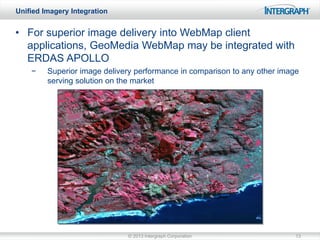
  • 13. Unified Imagery Integration • For superior image delivery into WebMap client applications, GeoMedia WebMap may be integrated with ERDAS APOLLO − Superior image delivery performance in comparison to any other image serving solution on the market © 2013 Intergraph Corporation 13
  • 14. Unified Geospatial Data Management • Comprehensive data management, analysis, and delivery system that enables an organization to crawl, catalog, describe and securely disseminate massive volumes of geospatial and business data © 2013 Intergraph Corporation 14
  • 15. Unified Geospatial Data Management • Improved administration • • • • All configuration options can be now done within the GUI Datasets can be copied, dragged, dropped, and viewed at all times Define authentication per service Virtual Mosaic, Geoservices, improved logging, and temporal support all available in the console © 2013 Intergraph Corporation 15
  • 16. Unified Geospatial Data Management • Group datasets together, limit by scale, and portray potentially thousands of datasets as a single virtual mosaic layer • Configure via the admin console http://demo.erdas.com.au/virtualmosaic/ © 2013 Intergraph Corporation 16
  • 17. Unified Geospatial Data Management • Enable temporal support and enable customers to build applications to highlight change over time © 2013 Intergraph Corporation 17
  • 18. Unified Geospatial Data Management • Protect intellectual property rights for data by watermarking © 2013 Intergraph Corporation 18
  • 19. Unified Geospatial Data Management • The existing ESRI ArcXML protocol has been upgraded to the new ESRI GeoServices Protocol found in the ArcGIS for Server platform • This allows ERDAS APOLLO customers to: − Serve imagery into ArcGIS clients natively without requiring client redevelopment − Benefit from ERDAS APOLLO’s superior image delivery performance in comparison to Esri ArcGIS for Server An ERDAS APOLLO Essentials dataset being served by Geoservices into Arcgis.com © 2013 Intergraph Corporation 19
  • 20. Unified Geospatial Data Management • Automatically relocate and catalog incoming data by setting up listeners on a ‘drop box’ − • Data is moved to target location, and then crawled into catalog Additional features: − − − Select any number of directories as drop box Create filters on data formats Couple with FTP server to create a remote drop box © 2013 Intergraph Corporation 20
  • 21. Unified Geospatial Data Management • Clip, Zip and Ship subsets of LASformatted point cloud data • Geospatial SDI façades − INSPIRE compliance for the view services − Select clip area − Select classifications − Filter by return value − Client-side functionality in Geospatial Portal © 2013 Intergraph Corporation 21
  • 22. Unified Geospatial Data Management • • • Interoperable and scalable spatial data Infrastructure Manage and serve secure or licensed information using standards-based web services Adheres to OGC, INSPIRE and ISO standards for web services and metadata compliance © 2013 Intergraph Corporation 22
  • 23. Unified Geospatial Data Management • Catalog Editor is now bundled with Geospatial SDI − Create, edit, and delete catalog metadata records, individually & enmass © 2013 Intergraph Corporation 23
  • 24. Unified Geospatial Client • • • • Browse & search the catalog View data Consume from APOLLO web services Download and CZS datasets − • Load to IMAGINE, Google Geoprocessing © 2013 Intergraph Corporation 24
  • 25. Unified Geospatial Client • Browser-based web application that acts as a client for spatial data services • Ready-to-run, browser-based portal enables users to find, view, query, analyze and consume geospatial data and standard web services delivered by Intergraph and/or third-party products • Provides ISO/OGC compliance and works with INSPIRE discovery, view, download and transformation services © 2013 Intergraph Corporation 25
  • 26. Unified Geospatial Client • • • • • Integrated database of available Coordinate Reference Systems (CRS) Easy to use search mechanism Server-side reprojection when working with ERDAS APOLLO or GeoMedia WebMap services Client-side reprojection of footprints and other miscellaneous vector shapes displayed in the browser Maintains area of interest when changing CRS on the client side © 2013 Intergraph Corporation 26
  • 27. Unified Geospatial Client • Runs on mobile devices − Automatically displays a simplified interface when viewed with a mobile device GUI • • • • Display, zoom and switch predefined maps Show feature attributes (GetFeatureInfo) Center the map based on device localization capabilities (GPS, A-GPS) On IOS based devices, Geospatial Portal supports pinching for zoom and pan activities © 2013 Intergraph Corporation 27