SlideShare a Scribd company logo
María Jesús Campos
learningfromgeography.wikispaces.com
Lithosphere
Itcomes from the
ancient Greek “lithos”
which means stone and
“sphaira” which means
sphere.

Itrefers to the solid
rocky crust that covers
the Earth.

The  crust is composed
of minerals.
   The crust is a solid layer that floates
    over the mantle’s magma.It represents
    1% of the Earth’s volume but it has
    different thickness and length.

   The crust is divided into tectonic plates
    that move over the mantle.

   The crust presents different shapes,
    lenghts, etc. Some times it appears
    under the oceans and others over the
    sea surface. This is called the Earth’s
    relief.

   The shapes of the Earth’s relief changes
    thanks to internal forces and external
    agents.
   200 million years ago all the
    continents were united into a
    single supercontinent called
    Pangea.
   Pangea broke up because of
    the internal forces of the
    mantel and the tectonic
    plates gradually moved apart.
    This theory is called
    continental drift.
   Tectonic plates slide against
    each other or move apart.
    Thus, the plate’s boundaries
    are unstable.
Lithospere
Lithospere
Lithospere
    Internal forces and pressures from the mantle causes
    the crust to:

     Fold: are deformations of the Earth’s surface where
      rock layers bend.
     Fault: are breaks in rock layers wher the rock is too
      hard to bend.
     Subducts: when one rock layer from a plate sinks
      under the other and its materials melts into the
      mantle’s magma.
Lithospere
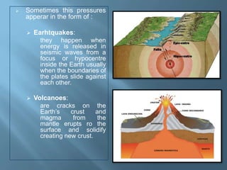
   Sometimes this pressures
    apperar in the form of :

       Earhtquakes:
          they happen when
          energy is released in
          seismic waves from a
          focus or hypocentre
          inside the Earth usually
          when the boundaries of
          the plates slide against
          each other.

       Volcanoes:
          are cracks on the
          Earth’s    crust    and
          magma       from     the
          mantle erupts ro the
          surface and solidify
          creating new crust.
   The external agents
    that shape the
    Earth’s surface are:
       Water
       Wind
       Vegetation
   They erode relief
    breaking it up and
    transporting and
    depositing eroded
    materials on a
    different place.
   Although human
    beings are not
    natural agents they
    also modify relief.
   The crust presents different shapes, lenghts,
    etc. Some times it appears under the oceans
    and others over the sea surface. This is called
    the Earth’s relief.
   The Earth’s relief comprises the forms and
    shapes of the Earth’s surface.
   Sometimes the Earth’s        The North Pole is not a
    crust appears over the        continent because it is
    sea surface and other         formed by frosted
    times under the sea           water.
    surface.
                                 Continents are
   Over the sea surface          separated by oceans or
    there are 6 continents:       seas:
       Africa                       Pacific Ocean
       Europe                       Atlantic Ocean
       América                      Indian Ocean
       Asia                         Artic Ocean
       Oceania                      Antartic Ocean or
       Antarctica                    Southern Ocean
                                     Mediterranean Sea
                                     Read Sea
Lithospere
   Mountains: High                 Valley: elongated lowland
    elevations of the Earth’s        between ranges of
    surface. When they are           mountains or hills.
    grouped together it is
    called range.
                                    Península: land mass
   Plateau: high flat areas         entirely surrounded by
    that are formed from             water except in one part
    eroded mountains.                connected with the
                                     mainland which is called
   Plain: low flat areas.           isthmus.
    Alluvial plains are formed
    by rivers and coastal           Island: a land mass
    plains are near the sea.         entirely surrounded by
                                     water.
   Basins: very low areas
    sometimes below sea             Cape: part of the coast
    level.                           that projects into the sea.
Lithospere
Lithospere
   Gulf: large area of a         Continental slope: the
    sea or ocean partially         descent from the
    enclosed by land.              continental shelf to the
   Bay: small area of a           ocean bottom.
    sea or ocean partially        Abyssal plain: huge
    enclosed by land.              under water plains that
   Ría: long narrow inlet         have an extension
    of the seacoast in             between 3000 and
    which the sea occupies         7000 metres deep.
    the mouth of the river.       Ocean trench: long
   Continental shelf:             valley on the ocean floor
    great underwater               that can have 11000
    plateau which                  metres deep.
    correspondt to the            Ocean ridge:
    border of a continent          underwater mountain
    and is usually less than       ranges.
    400 metres deep.
Lithospere
Created by María Jesús Campos
Chusteacher
Wikiteacher

More Related Content

PPTX
Major landforms of the earth
PPTX
UD3.- RELIEF AND LANDFORMS
PPTX
Landforms..this land is our land (Teach)
PPT
Features of earth`s surface
PPTX
Major land forms of the earth
PPT
Landforms Relief
PPTX
Landforms of the Earth
Major landforms of the earth
UD3.- RELIEF AND LANDFORMS
Landforms..this land is our land (Teach)
Features of earth`s surface
Major land forms of the earth
Landforms Relief
Landforms of the Earth

What's hot (20)

PDF
The Earth’s Relief
PPT
Chapter 14
KEY
Physical features
PPTX
Land formations
PPTX
Major Relief Features Of the Earth
PPT
The sea floor
PPTX
Landforms
PDF
Unit 7, Earth internal energy and relief, 2ESO
PPTX
Landforms on the earth
PPTX
Major landforms of the earth
PPS
Landforms
PPTX
Major land forms Of the Earth
PDF
Geological landforms
PPT
Ocean floor
PPTX
Ocean Bottom Topography
PDF
Major landforms of the earth
PPTX
Marine Provinces
PPTX
CBSE CLASS VII GEOGRAPHY
The Earth’s Relief
Chapter 14
Physical features
Land formations
Major Relief Features Of the Earth
The sea floor
Landforms
Unit 7, Earth internal energy and relief, 2ESO
Landforms on the earth
Major landforms of the earth
Landforms
Major land forms Of the Earth
Geological landforms
Ocean floor
Ocean Bottom Topography
Major landforms of the earth
Marine Provinces
CBSE CLASS VII GEOGRAPHY
Ad

Viewers also liked (7)

PPTX
Spain. IES Parque de Lisboa
PPTX
The Earth, the Geographic Coordinates
PPTX
Ad

Similar to Lithospere (20)

PPTX
The Lithosphere/Geosphere
DOCX
1º definitions relief
PPTX
Global Environment
PPT
The Earth
PPT
Unit2.theearth'srelief
PPTX
Unidad 8
PPTX
GOEGARPHY.pptx
PPTX
Landforms thislandisourland-111022123136-phpapp01
PPTX
Continents oceans & landforms
PPTX
What is a natural landscape
PPTX
UNIT 2. Geosphere
PPTX
UNIT 2. Geosphere
PDF
Theearthsrelief
PPTX
Land & Water Forms
PPT
slide 3.ppt
PPTX
UNIT 2. Geosphere
PPTX
Unit 2 relief
The Lithosphere/Geosphere
1º definitions relief
Global Environment
The Earth
Unit2.theearth'srelief
Unidad 8
GOEGARPHY.pptx
Landforms thislandisourland-111022123136-phpapp01
Continents oceans & landforms
What is a natural landscape
UNIT 2. Geosphere
UNIT 2. Geosphere
Theearthsrelief
Land & Water Forms
slide 3.ppt
UNIT 2. Geosphere
Unit 2 relief

More from María Jesús Campos Fernández (20)

PPTX
La Calidad en los Proyectos eTwinning
PPTX
eTwinning: Europa a tu alcance
PPTX
Cartographic Projections
PDF
Aprendizaje basado en proyectos
PPTX
Normativa sobre horarios docentes en Educación Secundaria
PPTX
Diseñando un Borrador de Proyecto Colaborativo: reflexiones sobre aprendizaje...
PPTX
La Calidad en eTwinning: guía y evaluación de proyectos eTwinning
PPTX
eTwinning: Buenas prácticas con sello de calidad o premio 2015-17
PPTX
Creando un borrador de proyecto colaborativo. Reflexiones sobre aprendizaje c...
PPTX
Registro en e twinning
PDF
Rúbrica de diseño de borrador de proyecto colaborativo
PPTX
E twinning buenas prácticas 2015 2016
PPTX
eTwinning el mundo a tu alcance
PPTX
The Reinassance: Painting
PPTX
The Reinassance: Sculpture
PPTX
Reinassance: Architecture
PPTX
Ancient Rome: Political Evolution
PPTX
Tertiary Sector: Other Activities
PPTX
Innovación y Colaboración en eTwinning
PPTX
The Tertiary Sector: Services. Trade
La Calidad en los Proyectos eTwinning
eTwinning: Europa a tu alcance
Cartographic Projections
Aprendizaje basado en proyectos
Normativa sobre horarios docentes en Educación Secundaria
Diseñando un Borrador de Proyecto Colaborativo: reflexiones sobre aprendizaje...
La Calidad en eTwinning: guía y evaluación de proyectos eTwinning
eTwinning: Buenas prácticas con sello de calidad o premio 2015-17
Creando un borrador de proyecto colaborativo. Reflexiones sobre aprendizaje c...
Registro en e twinning
Rúbrica de diseño de borrador de proyecto colaborativo
E twinning buenas prácticas 2015 2016
eTwinning el mundo a tu alcance
The Reinassance: Painting
The Reinassance: Sculpture
Reinassance: Architecture
Ancient Rome: Political Evolution
Tertiary Sector: Other Activities
Innovación y Colaboración en eTwinning
The Tertiary Sector: Services. Trade

Recently uploaded (20)

PPTX
Unit 4 Computer Architecture Multicore Processor.pptx
PDF
Trump Administration's workforce development strategy
PDF
Complications of Minimal Access-Surgery.pdf
PDF
Paper A Mock Exam 9_ Attempt review.pdf.
PDF
medical_surgical_nursing_10th_edition_ignatavicius_TEST_BANK_pdf.pdf
PDF
IGGE1 Understanding the Self1234567891011
PDF
David L Page_DCI Research Study Journey_how Methodology can inform one's prac...
PDF
HVAC Specification 2024 according to central public works department
PDF
BP 704 T. NOVEL DRUG DELIVERY SYSTEMS (UNIT 1)
PDF
FOISHS ANNUAL IMPLEMENTATION PLAN 2025.pdf
PDF
LDMMIA Reiki Yoga Finals Review Spring Summer
PDF
BP 704 T. NOVEL DRUG DELIVERY SYSTEMS (UNIT 2).pdf
PDF
International_Financial_Reporting_Standa.pdf
PDF
AI-driven educational solutions for real-life interventions in the Philippine...
PPTX
Share_Module_2_Power_conflict_and_negotiation.pptx
PDF
Practical Manual AGRO-233 Principles and Practices of Natural Farming
PPTX
20th Century Theater, Methods, History.pptx
PDF
Hazard Identification & Risk Assessment .pdf
PPTX
TNA_Presentation-1-Final(SAVE)) (1).pptx
PDF
Weekly quiz Compilation Jan -July 25.pdf
Unit 4 Computer Architecture Multicore Processor.pptx
Trump Administration's workforce development strategy
Complications of Minimal Access-Surgery.pdf
Paper A Mock Exam 9_ Attempt review.pdf.
medical_surgical_nursing_10th_edition_ignatavicius_TEST_BANK_pdf.pdf
IGGE1 Understanding the Self1234567891011
David L Page_DCI Research Study Journey_how Methodology can inform one's prac...
HVAC Specification 2024 according to central public works department
BP 704 T. NOVEL DRUG DELIVERY SYSTEMS (UNIT 1)
FOISHS ANNUAL IMPLEMENTATION PLAN 2025.pdf
LDMMIA Reiki Yoga Finals Review Spring Summer
BP 704 T. NOVEL DRUG DELIVERY SYSTEMS (UNIT 2).pdf
International_Financial_Reporting_Standa.pdf
AI-driven educational solutions for real-life interventions in the Philippine...
Share_Module_2_Power_conflict_and_negotiation.pptx
Practical Manual AGRO-233 Principles and Practices of Natural Farming
20th Century Theater, Methods, History.pptx
Hazard Identification & Risk Assessment .pdf
TNA_Presentation-1-Final(SAVE)) (1).pptx
Weekly quiz Compilation Jan -July 25.pdf

Lithospere

  • 2. Lithosphere Itcomes from the ancient Greek “lithos” which means stone and “sphaira” which means sphere. Itrefers to the solid rocky crust that covers the Earth. The crust is composed of minerals.
  • 3. The crust is a solid layer that floates over the mantle’s magma.It represents 1% of the Earth’s volume but it has different thickness and length.  The crust is divided into tectonic plates that move over the mantle.  The crust presents different shapes, lenghts, etc. Some times it appears under the oceans and others over the sea surface. This is called the Earth’s relief.  The shapes of the Earth’s relief changes thanks to internal forces and external agents.
  • 4. 200 million years ago all the continents were united into a single supercontinent called Pangea.  Pangea broke up because of the internal forces of the mantel and the tectonic plates gradually moved apart. This theory is called continental drift.  Tectonic plates slide against each other or move apart. Thus, the plate’s boundaries are unstable.
  • 8. Internal forces and pressures from the mantle causes the crust to:  Fold: are deformations of the Earth’s surface where rock layers bend.  Fault: are breaks in rock layers wher the rock is too hard to bend.  Subducts: when one rock layer from a plate sinks under the other and its materials melts into the mantle’s magma.
  • 10. Sometimes this pressures apperar in the form of :  Earhtquakes: they happen when energy is released in seismic waves from a focus or hypocentre inside the Earth usually when the boundaries of the plates slide against each other.  Volcanoes: are cracks on the Earth’s crust and magma from the mantle erupts ro the surface and solidify creating new crust.
  • 11. The external agents that shape the Earth’s surface are:  Water  Wind  Vegetation  They erode relief breaking it up and transporting and depositing eroded materials on a different place.  Although human beings are not natural agents they also modify relief.
  • 12. The crust presents different shapes, lenghts, etc. Some times it appears under the oceans and others over the sea surface. This is called the Earth’s relief.  The Earth’s relief comprises the forms and shapes of the Earth’s surface.
  • 13. Sometimes the Earth’s  The North Pole is not a crust appears over the continent because it is sea surface and other formed by frosted times under the sea water. surface.  Continents are  Over the sea surface separated by oceans or there are 6 continents: seas:  Africa  Pacific Ocean  Europe  Atlantic Ocean  América  Indian Ocean  Asia  Artic Ocean  Oceania  Antartic Ocean or  Antarctica Southern Ocean  Mediterranean Sea  Read Sea
  • 15. Mountains: High  Valley: elongated lowland elevations of the Earth’s between ranges of surface. When they are mountains or hills. grouped together it is called range.  Península: land mass  Plateau: high flat areas entirely surrounded by that are formed from water except in one part eroded mountains. connected with the mainland which is called  Plain: low flat areas. isthmus. Alluvial plains are formed by rivers and coastal  Island: a land mass plains are near the sea. entirely surrounded by water.  Basins: very low areas sometimes below sea  Cape: part of the coast level. that projects into the sea.
  • 18. Gulf: large area of a  Continental slope: the sea or ocean partially descent from the enclosed by land. continental shelf to the  Bay: small area of a ocean bottom. sea or ocean partially  Abyssal plain: huge enclosed by land. under water plains that  Ría: long narrow inlet have an extension of the seacoast in between 3000 and which the sea occupies 7000 metres deep. the mouth of the river.  Ocean trench: long  Continental shelf: valley on the ocean floor great underwater that can have 11000 plateau which metres deep. correspondt to the  Ocean ridge: border of a continent underwater mountain and is usually less than ranges. 400 metres deep.
  • 20. Created by María Jesús Campos Chusteacher Wikiteacher