Navr4030 16(tides)
- 1. Lesson 16: Advanced Navigation Systems
- 2. • AGENDA: – NAVSTAR Global Positioning System – Ship’s Inertial Navigation Systems (SINS) – Bottom Contour Navigation – LORAN-C – Electronic Charts (Raster & Vector) – Navigation Sensor System Interface (NAVSSI) • Applicable reading: Hobbs pp. 540-572. Lesson 20: Advanced Navigation Systems
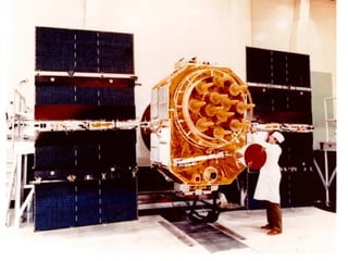
- 3. NAVSTAR Global Positioning System (GPS) • GPS = Global Positioning System – A space based, all-weather, jam resistant, continuous operation, worldwide radio navigation system. • Provides extremely accurate 3D location data as well as velocity and time. • 3 LOPs provide a Lat. & Long. • 4 LOPs provide Lat., Long. & Altitude
- 7. NAVSTAR GPS Specifications • Frequency: 1227 MHz, 1575 MHz • Range: Worldwide • Accuracy: next slide • 3 Types: – SPS- Standard Positioning Service – PPS-Precise Positioning Service – Differential GPS- for military only
- 8. NAVSTAR GPS Accuracy Standard Position Service (SPS) • Position: 100 m Hor. 150 m Vert. • Velocity: .5 m/sec • Time: 1 milli- second Precise Position Service (PPS) - Military • Position: 16 m Hor. 25 m Vert. • Velocity: .1 m/sec • Time: 100 nano- seconds
- 9. NAVSTAR GPS Uses Civilian Uses • Marine Navigation • Law Enforcement • Hydrographic surveying • Search and Rescue • Collision avoidance Military Uses • Marine Navigation • Air Navigation • Rendezvous • Close Air Support • Mine Warfare • Unmanned Aerial Vehicles (UAVs)
- 10. Differential GPS • A receiving station located at a fixed, known location receives fix information from GPS. • The fix obtained from GPS is compared to the known location of the station. • Any difference between these two is due to GPS error.
- 11. Differential GPS • GPS error information is then transmitted to vessels operating in the area. • The resulting fix accuracy is 2-5 meters using the differential technique • Requires more than 1 receiver
- 12. GPS Advantages • Continuous Coverage (regardless of weather) • worldwide coverage • 3-D locator • Precise Timing Standard Disadvantages • Vulnerable to Attack
- 13. Inertial Navigation Systems • Inertial Navigation: the process of directing the movements of a vessel based on sensed accelerations in known spatial directions. • System uses: – Gyroscopes – Accelerometers – Electronic computers
- 14. Inertial Navigation Systems Current position is inputted Spinning gyro Accelerometer Computer Xo F=m*a Through Differentiation we get velocity and position (V and Xf) Known mass
- 15. Inertial Navigation Systems • Two types: – SINS (Ship’s Inertial Navigation System) • first used in 1960s • getting phased out • must be reset periodically – ESGN (Electrostatic Gyroscopic Navigation) • operates in a near perfect vacuum • rotor is solely supported by an electrostatic field • essentially frictionless • resets only required once every 30 days
- 16. Bottom Contour Navigation • Establishes position by using the geographic features of the ocean floor. • An echo sounder (fathometer) is used to produce a trace of the ocean floor beneath the vessel, which can be compared to a bottom contour chart to establish the ship’s position.
- 17. Bottom Contour Navigation • 2 Techniques: – Line-of-Soundings (page 567 in Hobbs) – Contour Advancement (page 568 in Hobbs)
- 18. Bottom Contour Navigation Advantages • no satelites required • subs=> no need to go to Periscope Depth (PD) • not vulnerable Disadvantages • not very accurate • requires a cooperative sea bottom
- 19. LORAN (Long Range Navigation) • Over the years, many ground based electronic navigation systems were developed prior to satellite based systems becoming possible. • Most of these have been taken out of service, but LORAN still enjoys popularity and is still widely used.
- 20. LORAN (cont) • The operating principles of the system are similar to those now used by GPS. • Ground stations, at known locations, transmit signals at a predetermined time. • These signals are received by vessels at sea, and the time delay is used to form a range LOP.
- 21. LORAN (cont) • First established in 1957. • Theory-hyperbolic LOPs based on time differences between master and secondary stations. • Run by the Coast Guard • Frequency: 100 kHz (LF) • Range: 1200 nm • Accuracy: 200-500 yds
- 22. Electronic Charts • Electronic Chart Display Systems (ECDS) • Raster Chart Display Systems (RCDS)
- 23. Navigation Sensor System Interface (NAVSSI) • Provides/Distributes NAV data (precise position, time, velocity, pitch-roll-yaw) to multiple users. • NAVSSI has been successfully installed, interfaced, and tested with WSN-5, WRN-6, EM Log, Tomahawk, Outboard, and NTCS-A.
- 25. Homework • Ch. 30 – Section 1: 1 – Section 2: 1, 5, 6, 9 • Ch. 31 – #4c, 5, 6
Editor's Notes
- #2: “Getting Acquainted Lecture” Instructor Bio: Commissioned May, 1993; NROTC Unit, IIT Reported to Hue City (CG-66) homeported in Mayport, FL for a 42 mos tour 24 mos - Engineering Dept (Auxiliaries Officer & Damage Control Assistant) 18 mos - Operations Dept (Air Warfare Officer/BW Flag Liaison Officer) Command Employment (while aboard Hue City) 1995 Med Deployment 95-2 with USS Theodore Roosevelt 1996 Baltops ‘96 (Scandinavian countries) 1997 Med Deployment 97-2 with USS John F. Kennedy Midshipmen Cruises (emphasize student contribution to course) CV (CV 63) - Secrest Tico’s (LKE, VLG) -Waterston, Pope, Sullivan Burkes (DDG 61) - Kuckel OH Perry (FFG 61) - Phillips LHA/LHD (LSD 44) - Fink, Sutherland AOE (AOE-8) - Hertel Review Syllabus: Course objectives Course resources (webpage, Textbook, Workbook) Case studies - provide vivid and intriguing examples of the the fundamental principles taught in this course.


