Sentinel 2
1 like1,995 views

The document provides information about accessing and using data from the Sentinel-2 satellite mission. It outlines several portals for downloading Sentinel-2 imagery, including the ESA SciHub, Amazon Web Services, and USGS websites. It describes how to search for and filter imagery using criteria like date, cloud cover percentage, and region. The document also defines some key terms related to Sentinel-2 imagery like granules, datastrips, and datatakes. It lists the spatial resolutions of the different spectral bands and gives examples of pre-processing steps that can be applied to the data like resampling, atmospheric correction, and classification.


![3. Insert search criteria
: In what date are you
interested? L2A
: tick the Sentinel-2 Mission.
: We want L2A data So
select . Specify a cloud cover:
Percentage range. [0 - 100] (in % of cloud cover).
: Thats it!](https://image.slidesharecdn.com/jmwaurasentinels2-1-171125065853/85/Sentinel-2-6-320.jpg)


Sentinel 2
- 1. Remote Sensing Thursday, 16 November 2017 J.Mwaura HANDS-ON TRAINING
- 2. • Sentinel-2 - High Resolution satellite • Sentinel-2A – 2015 - data from November • Sentinel-2B – 2017 • MultiSpectral optical Imagery (MSI) for the Europe's Global Monitoring for Environment and Security (GMES) programme
- 3. & select the – https://scihub.copernicus.eu/dhus/#/home • Amazon Web Service – http://sentinel-pds.s3-website.eu-central- 1.amazonaws.com/ • USGS Explorer website – http://earthexplorer.usgs.gov/ • Community Image Data portal (CID) – https://cidportal.jrc.ec.europa.eu/forobs/sentinel.py
- 4. • Sentinel-2 L2A images ( cloud mask) 1. Go to the ESA SciHub
- 5. 2. Search for an image
- 6. 3. Insert search criteria : In what date are you interested? L2A : tick the Sentinel-2 Mission. : We want L2A data So select . Specify a cloud cover: Percentage range. [0 - 100] (in % of cloud cover). : Thats it!
- 7. 3. Insert search criteria 4.
- 8. • AWS Sentinel 2 portal: •
- 9. Browse through data, in the menu to the left, • choose region, • time span • Admissible cloud cover
- 10. • Click a desired cell - details of the image
- 11. • Click link, -to download the images Note that the tiles are identified as 100 km2 tile on a so called MGRS system
- 12. • Access via browser
- 13. • Log monitor -download the Sentinel 2 data and check the status and history of your queries
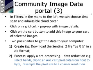
- 14. • In Filters, in the menu to the left, we can choose time span and admissible cloud cover • Click on a grid cell, - pop-up with image details. • Click on the cart button to add this image to your cart of selected images. • Two possibilities to get the data to your computer: 1) Create Zip: Download the Sentinel 2 file “as it is” in a zip format; 2) Process: apply a pre-processing – data reduction e.g select bands, clip to an AoI, cast pixel data from float to byte, resample the pixel size to a coarser resolution
- 16. • Datatake – the continuous acquisition of an image from one Sentinel-2 satellite in a given MSI imaging mode. – maximum length of approximately 15,000 km • Datastrip – a portion of image downlinked during a pass to a given station – maximum length of approximately 5,000 km
- 17. • A granule is the minimum indivisible partition of a product (containing all possible spectral bands). – For Level-0C, Level-1A and Level-1B, granules are sub- images of a detector with a given number of lines along track. – A granule covers approximately 25 km across track and 23 km along track. – For Level-1C, the granules, also called tiles, are 100 km2 ortho-images in UTM/WGS84 projection.
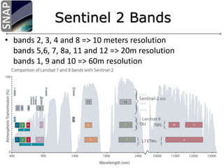
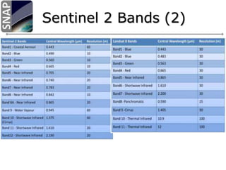
- 18. • bands 2, 3, 4 and 8 => 10 meters resolution bands 5,6, 7, 8a, 11 and 12 => 20m resolution bands 1, 9 and 10 => 60m resolution
- 20. • Pre – processing – Resampling, • ensures that images of each band have the same resolution and number of pixels – Atmospheric Correction and • Atmospheric/Topographic Correction – Subset selection • re-choosing specific areas of interests • Classification • Index-based classification – NDVI, NDWI e.t.c
- 21. Thanks….