Using Critical Gradient Data To Predict Dnapl
1 like564 views

The document presents two case studies using critical gradient data to predict DNAPL (dense non-aqueous phase liquid) migration at contaminated sites. The first case involves a former wood treating facility with unique geological challenges affecting creosote DNAPL mobility, while the second examines a coal tar processing facility, highlighting migration through bedrock fractures. Both studies address the feasibility of evaluating vertical gradients and the implications for groundwater modeling and DNAPL collection systems.


Using Critical Gradient Data To Predict Dnapl
- 1. By N.J. Misquitta, T.E. Jordan, P.D. Sorek, and M.D. Brourman Using Critical Gradient Data to Predict DNAPL Migration
- 2. Todays Presentation Two Case Studies Presented Background Information & Site Conditions Problem Statement NAPL properties Observations and Conclusions
- 3. Case Study #1: Former Wood Treating Facility New England Region Located on river terrace and floodplain deposits. Geology: Fluvial and glacial till overlying metasedimentary bedrock. Downward gradients beneath the Site Upward gradients at adjacent river.
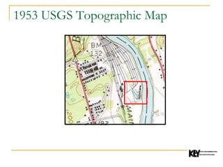
- 7. 1953 USGS Topographic Map
- 8. 1953 USGS Topographic Map
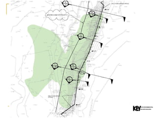
- 12. Cross Section Looking South
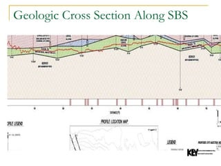
- 13. Geologic Cross Section Along SBS
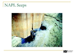
- 15. NAPL Seeps
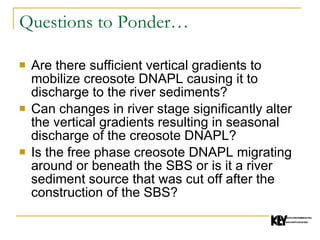
- 16. Questions to Ponder… Are there sufficient vertical gradients to mobilize creosote DNAPL causing it to discharge to the river sediments? Can changes in river stage significantly alter the vertical gradients resulting in seasonal discharge of the creosote DNAPL? Is the free phase creosote DNAPL migrating around or beneath the SBS or is it a river sediment source that was cut off after the construction of the SBS?
- 17. Problems to Address Can the above questions be efficiently evaluated to determine their feasibility prior to development of a groundwater model? Will we be able to use this model to locate future piezometers for the evaluation of the SBS? How can we efficiently extrapolate groundwater gradient data across the SBS given the limited number of monitoring wells? Spatial data for this Site are mostly in hardcopy format with little available in a digital format making construction of a groundwater model a time consuming task.
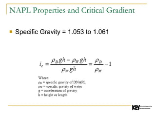
- 18. NAPL Properties and Critical Gradient Specific Gravity = 1.053 to 1.061
- 19. Flow Net – Non-Leaky Barrier Wall
- 20. Flow Net – Leaky Barrier Wall
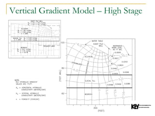
- 21. Vertical Gradient Model – High Stage
- 22. Vertical Gradient Model – Low Stage
- 23. Results The results from the critical gradient modeling were used to develop a plan for installing piezometers for subsequent evaluation of the effectiveness of the SBS through a series of dye injection tests. These results were used for the development of a sub-river bottom DNAPL collection system located downgradient of the SBS.
- 24. Case Study #2: Former Coal Tar Processing Facility Midwestern Location Site on hillside adjacent to partially filled glacial valley and river. Downward hydraulic gradients beneath the Site. Upward hydraulic gradients in the glacial valley. Geology consists of glacial drift overlying fractured Mississippian sedimentary bedrock.
- 25. Background Information Free phase coal tar with a specific gravity of 1.09 (DNAPL) was released over a period of several decades at a coal tar processing and refining plant. Coal tar plume has migrated 1.3 km from source area. Coal tar plume is located in zone 10 m beneath the top of bedrock. Coal tar plume is approximately 3 to 6m thick.
- 27. Questions to Ponder… Why does the coal tar DNAPL not discharge to the adjacent stream? Why is coal tar DNAPL not found in the glacial drift deposits in downgradient areas of the buried glacial valley bottom? Why is coal tar DNAPL found at a relatively constant depth interval in the fractured bedrock? Why is coal tar DNAPL found in some areas of the fractured bedrock and not others?
- 28. Critical Gradient Concept Cohen and Mercer (1993) described the critical gradient as the minimum gradient required for overcoming hydrostatic and capillary pressures. In terms of DNAPL, it is the minimum gradient necessary to initiate movement of DNAPL in the subsurface.
- 29. Vertical Gradient Analysis Downward gradients ranged from 0.05 to 0.23 beneath the source area. Upward gradients in the stream valley of 0.01 to 0.06. DNAPL specific gravity is 1.09.
- 30. Lateral NAPL Migration in Bedrock The critical gradient is expected to be highly variable within the fracture network due to large variations in fracture aperture and DNAPL filled fracture length. The high end member of critical gradient is calculated based on a fracture aperture of 20 microns (0.002 cm), which is considered to be the smallest space in which DNAPL can be transmitted (Cohen and Mercer, 1993), and a relatively short filled fracture length of 0.3m. The low end member of the critical gradient is calculated with a fracture aperture of 1,000 microns (0.1 cm), which represents an open, yet fairly small fracture and an assumed maximum pool length of 15m.
- 31. Critical Gradient for Fracture Flow Where: ρ D = specific gravity of DNAPL ρ W = specific gravity of water g = acceleration of gravity h = height or length σ = interfacial tension θ = contact angle r = pore throat radius or fracture aperture z = DNAPL body radius
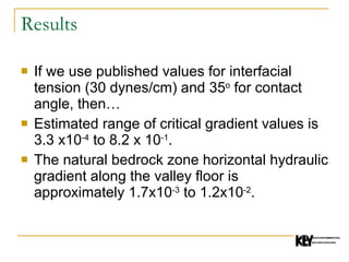
- 32. Results If we use published values for interfacial tension (30 dynes/cm) and 35 o for contact angle, then… Estimated range of critical gradient values is 3.3 x10 -4 to 8.2 x 10 -1 . The natural bedrock zone horizontal hydraulic gradient along the valley floor is approximately 1.7x10 -3 to 1.2x10 -2 .
- 33. Results It is known that the coal tar DNAPL has migrated 1.3 km away from the source area by following a network of bedrock fractures. The results of the critical gradient analysis suggests that the coal tar DNAPL in the bedrock is transmitted via open, relatively long fractures in order to be mobilized by the natural hydraulic gradient. Any coal tar DNAPL present in relatively small (i.e. hairline) fractures and/or in disconnected lenses is anticipated to be immobile under the natural conditions. Furthermore, the DNAPL migration pathway appears to coincide with a bedrock facies change between sandstone of the valley walls and siltstone and limestone in the valley bottom and does not appear to coincide with axis of the valley bottom.