Uses of Rivers
Download as PPT, PDF4 likes16,052 views

The document discusses rivers and the hydrological cycle. It begins by explaining how rivers are an important resource for drinking water, transport, electricity and more. It then describes the three main processes by which rivers shape the land - erosion, transportation, and deposition. Erosion involves wearing away river banks and breaking down rock particles. As rivers transport sediment downstream, larger rocks can be moved in higher energy areas near the source, while finer particles are deposited where energy is lowest at the mouth. The document outlines the typical features of the upper, middle and lower courses of a river as its energy decreases downstream.


Uses of Rivers
- 1. Rivers
- 2. Learning Intention How people use rivers? Why is water and rivers important? Why study rivers? What is the hydrological cycle?
- 4. What good are rivers?
- 7. Why study rivers? Rivers In the news Deaths Damage Effect on man Food Water
- 8. Rivers Water is an important resource we all need to live and survive. 70% of our bodies are water. We see water all around us in the sea, lakes, ponds and rivers. We are now going to take you on a journey to find where our water comes from and how rivers affect our lives.
- 11. List of Water Uses In pairs discuss each persons list of uses for rivers Has people’s reliance on rivers changed? How?
- 12. Uses of rivers Make a spider diagram Washing Wash hands Drinking water Swimming Bath Cooking Fishing Water sports Dams Electricity (HEP) Crops Transport (move things and people) eg boats Sprinklers Factories Bread Water golf courses
- 13. Top uses of water Put list of uses for rivers in order of importance for: 1. Today 2. The past
- 14. Past uses of water No washing machines/ dish washers– wash by hand More travel by boat, few went by plane More baths, less showers No sprinklers Less swimming pools – more swims in the lake No automated car washes Fewer golf courses – use a lot of water
- 15. Our use of water
- 16. Use water wisely – don’t waste it
- 17. Write an account Write an account of your group discussion. Write about how our use of rivers has changed over time.
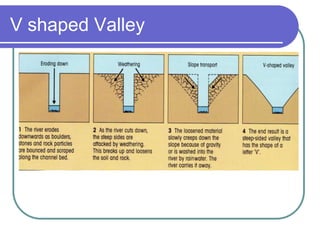
- 19. 1. Source: the point at which the river starts. 2. Interlocking spurs: where the river winds between ridges. 3. Gorge: deep valley caused by wearing back of a waterfall. 4. Waterfall: often where the river crosses a band of harder rock. 5. 'V' shaped valley: produced in upper course because the river cuts down more quickly than the surrounding slopes are eroded.
- 21. V shaped Valley
- 23. 6. Meander: the river starts to erode from side to side. 7. River cliff: the river moves faster on the outside of the bend and cuts into the valley side. The erosion undercuts the ground causing it to collapse, leaving a cliff. 8. River beach (Slip-off slope): the river moves more slowly on the inside of the bend. It cannot carry the larger pebbles and these are dropped here.
- 25. 9. Ox-bow lake: during floods the river cuts through the neck of a large meander. The outside bend is left as a shallow lake. 10. Flood plain: the river is flowing in a very wide, flat valley. When it floods, it spreads over the flood plain. 11. Levée: during floods the overflowing river is slowed as it leaves its bed. Silt is deposited along the banks first. Over the years the deposits build up into high ridges. 12. Estuary: the open mouth of the river, where it meets the sea.
- 26. River channel A river is fresh water flowing across the surface of the land, usually to the sea. It flows in a channel. The bottom of the channel is called the bed and the sides of the channel are called the banks.
- 28. The drainage basin of a river
- 29. River terms Source - The source is the beginning of a stream or river. Mouth - The mouth is the end of a river, where it empties into a large body of water. Tributary - A tributary is a river or stream that flows into another stream, river, or lake. Confluence – to the point where a tributary joins a larger river. Drainage basin – the area drained by a river and its tributaries. Watershed – the boundary of the drainage basin which is usually a ridge of high land.
- 31. Give the meanings of these words SOURCE WATERSHED TRIBUTARY CONFLUENCE MOUTH RIVER CHANNEL DRAINAGE BASIN DELTA
- 32. Answe rs SOURCE The place where a river starts, usually in high ground. Can be in the form of a spring, lake or glacier. WATERSHED The area of highland which forms the edge of a drainage basin. TRIBUTARY A small stream which flows into a larger one, adding water to it and making it bigger. DRAINAGE BASIN An area of land drained by a river and its tributaries. MOUTH The end of a river's course, where it flows into the sea or a lake. CHANNEL The space between the banks of a river where it flows. CONFLUENCE The point where a small stream flows into the main channel, or where 2 small streams join. DELTA A landform where the mouth of a river flows into an ocean, sea, desert, estuary, lake or another river.
- 33. Fill in the spaces putting in the missing terms and the missing definitions The place where a river starts, usually in high ground. Can be in the form of a spring, lake or glacier. WATERSHED TRIBUTARY An area of land drained by a river and its tributaries. MOUTH CHANNEL The point where a small stream flows into the main channel, or where 2 small streams join. DELTA
- 34. Shaping the land The river works to shape the land. It does it in 3 ways: 1. Erosion – wears away the land 2. Transportation – moves the material from one place to another 3. Deposition – drops the material and builds new landforms
- 35. What is erosion? Erosion is the wearing away of the land (like sandpaper) Weathering breaks up and weakens the surface of the rocks while erosion wears away and removes the loosened material
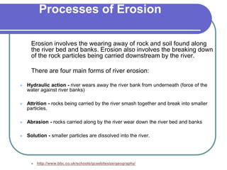
- 39. Processes of Erosion Erosion involves the wearing away of rock and soil found along the river bed and banks. Erosion also involves the breaking down of the rock particles being carried downstream by the river. There are four main forms of river erosion: Hydraulic action - river wears away the river bank from underneath (force of the water against river banks) Attrition - rocks being carried by the river smash together and break into smaller particles. Abrasion - rocks carried along by the river wear down the river bed and banks Solution - smaller particles are dissolved into the river. http://www.bbc.co.uk/schools/gcsebitesize/geography/
- 42. Transport Rivers pick up and carry material as they flow downstream. A river may transport material in four different ways: Solution - minerals are dissolved in the water and carried along in solution. Suspension - fine light material is carried along in the water. Saltation - small pebbles and stones are bounced along the river bed. Traction - large boulders and rocks are rolled along the river bed.
- 43. Rivers need energy to transport material, and levels of energy change as the river moves from source to mouth. When energy levels are very high, large rocks and boulders can be transported. Energy levels are usually higher near a river's source, when its course is steep and its valley narrow. Energy levels rise even higher in times of flood. When energy levels are low, only small particles can be transported (if any). Energy levels are lowest when velocity drops as a river enters a lake or sea (at the mouth).
- 44. Deposition When a river loses energy, it will drop or deposit some of the material it is carrying. Deposition may take place when a river enters shallow water or when the amount of water decreases - for example, after a flood or during times of drought. Deposition is common towards the end of a river's journey, at the mouth. Deposition at the mouth of a river can form deltas - for example, the Mississippi Delta
- 45. The rivers course Large boulders in the river. River narrow and shallow Large rocks in the river. River getting wider and deeper Small pebbles in river. River at its widest and deepest.
- 46. 3 stages of the river The journey of river from source (where the river begins) to mouth (where the river ends) is sometimes called the course of the river. The course of a river can be divided into three main sections: upper course middle course lower course
- 47. Rivers always flow downwards from highland areas to lowland areas, through the upper, middle, and finally the lower course.
- 48. Upper course The land is steep here. River has very little water. River is narrow and shallow.
- 50. Continent Longest River Length Africa Nile River 4,157 miles (6,690 km) long Asia Yangtze River 3,434 miles (5,530 km) long Australia Murray-Darling River 2,310 miles (3,720 km) long North America Mississippi- Missouri River 2,540 miles (4,090 km) + 2,340 miles (3,770 km) long South America Amazon River 3,915 miles (6,300 km) long Europe Volga River 2,290 miles (3,700 km) long
- 51. Erosion Erosion involves the wearing away of rock and soil found along the river bed and banks. Erosion also involves the breaking down of the rock particles being carried downstream by the river. There are four main forms of river erosion: Hydraulic action - river wears away the river bank from underneath Attrition - rocks being carried by the river smash together and break into smaller particles Abrasion - rocks carried along by the river wear down the river bed and banks Solution - smaller particles are dissolved into the river http://www.bbc.co.uk/schools/gcsebitesize/geography/riverswate r/riverprocessesrev1.shtml