


![Course: Geography of Pakistan, Part-I (9351)
Semester: Autumn, 2019
10
hydrology to build complex irrigation works in Sri Lanka, also known for invention of the Valve Pit which
allowed construction of large reservoirs, anicuts and canals which still function.
Marcus Vitruvius, in the first century BC, described a philosophical theory of the hydrologic cycle, in which
precipitation falling in the mountains infiltrated the Earth's surface and led to streams and springs in the
lowlands.[citation needed] With the adoption of a more scientific approach, Leonardo da Vinci and Bernard
Palissy independently reached an accurate representation of the hydrologic cycle. It was not until the 17th
century that hydrologic variables began to be quantified.
Pioneers of the modern science of hydrology include Pierre Perrault, Edme Mariotte and Edmund Halley. By
measuring rainfall, runoff, and drainage area, Perrault showed that rainfall was sufficient to account for the flow
of the Seine. Mariotte combined velocity and river cross-section measurements to obtain a discharge, again in
the Seine. Halley showed that the evaporation from the Mediterranean Sea was sufficient to account for the
outflow of rivers flowing into the sea.[2]
Advances in the 18th century included the Bernoulli piezometer and Bernoulli's equation, by Daniel Bernoulli,
and the Pitot tube, by Henri Pitot. The 19th century saw development in groundwater hydrology,
including Darcy's law, the Dupuit-Thiem well formula, and Hagen-Poiseuille's capillary flow equation.
Rational analyses began to replace empiricism in the 20th century, while governmental agencies began their
own hydrological research programs. Of particular importance were Leroy Sherman's unit hydrograph, the
infiltration theory of Robert E. Horton, and C.V. Theis' aquifer test/equation describing well hydraulics.
Since the 1950s, hydrology has been approached with a more theoretical basis than in the past, facilitated by
advances in the physical understanding of hydrological processes and by the advent of computers and
especially geographic information systems (GIS). (See also GIS and hydrology)
Q.4 Define the agricultural industry? Give your arguments that how stock, poultry and fishing had
become the industries in Pakistan?
Agriculture is a vital sector of Pakistan's economy and accounted for 25.9 percent of GDP in 1999-2000,
according to government estimates. The sector directly supports three-quarters of the country's population,
employs half the labor force , and contributes a large share of foreign exchange earnings. The main agricultural
products are cotton, wheat, rice, sugarcane, fruits, and vegetables, in addition to milk, beef, mutton, and eggs.
Pakistan depends on one of the world's largest irrigation systems to support production. There are 2 principal
seasons. Cotton, rice, and sugarcane are produced during the kharif season, which lasts from May to November.
Wheat is the major rabi crop, which extends from November to April. The key to a much-needed improvement
of productivity lies in a more efficient use of resources, principally land and water. However, change is
dependent on the large landowners who own 40 percent of the arable land and control most of the irrigation
system, which makes widespread reform difficult. Assessments by independent agencies, including the World
Bank, show these large landholdings to be very unproductive. Pakistan is a net importer of agricultural](https://image.slidesharecdn.com/9351-12-220514061649-613e6c19/85/9351-12-doc-10-320.jpg)


9351-12.doc
- 1. Course: Geography of Pakistan, Part-I (9351) Semester: Autumn, 2019 1 ASSIGNMENT No. 1 Q.1 Define the term Physiography? Discuss its three major features including mountains, plateaus and plains. Landforms Weathering, water, elevation, sinking, and erosion of the soil are constantly shaping the surface of the Earth. It doesn’t really happen overnight but takes hundreds and thousands of years for us to notice these changes. These are the natural processes that lead to various formations of the Landforms. Landforms originate from these geological processes. Let’s understand the processes that shape the landforms. External Process External process means effects caused by the external factors such as rain or wind. Erosion occurs when material on the surface like soil and rocks which are called sediments are deposited or dropped off in a different location. These natural processes change the surface of the Earth. Erosion and Deposition are the processes that are occurring externally. Internal Process Needless to say, internal processes occur inside the surface of the Earth, beneath the crust. The internal process, like Volcanic eruption and Plate tectonics, are caused because of the intense heat in the Earth’s core that causes molten rock in the mantle layer to move thus creating uneven movement on the surface. These layers are either uplifting or sinking. Landforms can be categorized into Mountains, Plateaus, and Plains depending upon their elevation and slope. Let us look at them individually. Source: wpclipart
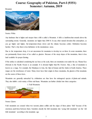
- 2. Course: Geography of Pakistan, Part-I (9351) Semester: Autumn, 2019 2 Mountain Source: Wikia Any landmass that is higher and steeper than a hill is called a Mountain. A hill is a landform that extends above the surrounding terrain. Generally, mountains are higher than 2000 ft. In any other natural elevation like atmosphere, as you go higher and higher, the temperature drops down and the climate becomes colder. Habitation becomes harsher. That’s why there is less habitation in the mountainous areas. Due to the temperature drop, it is not uncommon for mountains to develop ice on them. In some mountains, there are permanently frozen rivers of ice called as glaciers. Because of the steep slopes of the mountains, there is less land available for proper farming. If the surface is calculated considering the sea base as the scale, there are mountains even under the sea. Mauna Kea (Hawaii) in the Pacific Ocean is an example. It is elevated higher than Mt. Everest. Also, a line of mountains is known as a range. For example, the Himalayas in Asia, the Alps in Europe and the Andes in South America. These ranges are the storehouses of water. Many rivers have their origins in these mountains, the glaciers of the mountains are the source of these rivers. Mountains are generally untouched by civilisations are thus have the endangered species of plants and animals. They also inhibit a rich variety of flora and fauna. Mountains are further divided into three categories: 1. Fold Mountains Source: Quora Fold mountains are created when two tectonic plates collide and the edges of these plates ‘fold’ because of the enormous push force between them. Scientists classify the fold mountains into ‘young fold mountains’ are the ‘old fold mountains’ according to the mountains age.
- 3. Course: Geography of Pakistan, Part-I (9351) Semester: Autumn, 2019 3 The young fold mountains are between 10 and 25 million years old such as the Himalayas in Nepal, the Alps in Europe and the Andes in South America. Now, the old fold mountains are older than 200 million years old such as the Aravalli mountains in India (Rajasthan) Ural mountain in Russia. 2. Block Mountains Source: Quora Block mountains occur when large areas are broken and displaced vertically. These large areas of rock, sometimes stretching across hundreds of kilometres are created by tectonic and localized stresses in the Earth’s crust. The uplifted blocks are termed as horsts. The lowered blocks are called grabens. They resemble piano keys. The examples of block mountains are the Rhine valley and the Vosges mountain in Europe. 3. Volcanic Mountains Source: HubPages Volcanic mountains are formed by magma rising up from the mantle to the crust of the earth. The example of volcanic mountains is Kilimanjaro and Mount Fuji.
- 4. Course: Geography of Pakistan, Part-I (9351) Semester: Autumn, 2019 4 Plateaus Plateaus are elevated flatlands. It is a flat land which is standing above the surrounding area. Plateaus may have one or more sides with steep slopes. Depending upon the plateau their height varies from a few hundred meters to several thousand meters. The most familiar plateau in India is the Deccan Plateau and these plateaus are mainly formed by lava, meaning they are volcanic in origin. The extension of Deccan Plateau is the Chhotanagpur plateau in India. It’s a reserve for minerals such as iron ore, manganese and coal. African plateau is most famous for gold and diamond mining. The Tibetan plateau is the highest plateau in the world. Plateau regions give birth to the waterfall, for example, Hundru falls in the Chhotanagpur plateau and the Jog falls in Karnataka. These plateaus are also centres for tourism and scenic activities. Plains Source: NYTimes Plains are the most fertile regions. They are stretches of large land. The predominant activity is the primary sector in plains which is A surrounding. These stretches of land are the most suitable for human habitation and agriculture activities like farming and poultry.
- 5. Course: Geography of Pakistan, Part-I (9351) Semester: Autumn, 2019 5 Plains are formed by rivers and their tributaries. The rivers flow down the mountains and erode them. They deposit sediments along their courses and in valleys. It is from these deposits that plains are formed. In India, the Indo- Gangetic plains are the most densely populated regions of the country. Where there is water, there is life. Q.2 Write notes on the following: i. Vegetations and its variety Scientists divide the Earth’s land into what are called vegetation regions. These areas have distinct types of plants, soil, and weather patterns. Vegetation regions can be divided into five major types: forest, grassland, tundra, desert, and ice sheet. Climate, soil, the ability of soil to hold water, and the slope, or angle, of the land all determine what types of plants will grow in a particular region. Forest Forests are areas with trees grouped in a way so their leaves, or foliage, shade the ground. Forests can be found just about anywhere trees can grow, from below sea level to high in the mountains. From tropical rain forests near the Equator to boreal forests in cold climates close to the Arctic Circle, different types of forests can be found all over the world. One way to classify different types of forests is by the type of trees a forest has. Deciduous forests have trees with green leaves that change color in the fall and drop altogether in the winter. Trees that are common in deciduous forests are oak and maple. The northeastern United States is covered in deciduous forest, and tourists flock to the area every autumn to experience the orange, yellow, and red leaves blanketing the region. Evergreen forests have trees with leaves that stay green all year long. One of the places evergreen forests can be found is on the opposite side of the North American continent—in the Pacific Northwest, which includes the Canadian province of British Columbia and the U.S. states of Washington and Oregon. The Pacific Northwest is full of evergreen trees like fir. Sometimes forests are classified by the type of leaves on their trees. Trees in broad-leaved forests have wide, flat leaves. Tropical rain forests are a type of broad-leaved forest. Tropical rain forests, such as Brazil’s Amazon Basin rain forest, are found near the Equator. They contain more than half of the world’s biodiversity, or variety of plant and animal species. Coniferous forests have trees with cones and needles instead of leaves. Coniferous forests have the tallest (coast redwood), largest (giant sequoia), and oldest (bristlecone pine) trees in the world.
- 6. Course: Geography of Pakistan, Part-I (9351) Semester: Autumn, 2019 6 Many forests are mixed, meaning they have both broadleaf and coniferous trees. The eucalyptus forests of Australia are mixed forests, for instance. The evergreen eucalyptus trees are mixed with deciduous trees like beech. Grassland Grasslands are, as their name suggests, flat and open areas where grasses are the dominant type of vegetation. Grasslands can be found on every continent except Antarctica. Climate plays a role in the type of grassland you get. In cool, mild climates, like northwest Europe, grasslands are dominated by tough vegetation, such as oats, that thrives all year. Some of these grasses are so tough and hardy that they are considered weeds. In warmer climates, seasonal vegetation survives better. Temperate grasslands exist where there are seasonal variations in temperature over the course of the year: hot summers and cold winters. Different grasses thrive in different temperatures here. Temperate grasslands exist from the prairies of North America to the veld, or rural grassland, of South Africa. Tropical grasslands are called savannas. They do well in weather that is warm year-round and usually pretty dry. The most famous savannas are in Africa. Serengeti National Park, in Tanzania, has three distinct types of savanna grassland: long grass, intermediate grass, and short grass. This part of the Serengeti is known as the Serengeti Plains, and it supports wildlife from aardvarks to zebras. Grasslands are important for milk and dairy production; dairy cows are happiest, and most productive, in areas in which they can munch on grass all day. Tundra Tundra is an area where tree growth is difficult because of cold temperatures and short seasons. Vegetation in tundra is limited to a few shrubs, grasses, and mosses. Scientists estimate roughly 1,700 different species live in the tundra, which isn’t much compared to forests and grasslands. The ground is often too cold for plants to set down roots, and without plants, few animal species can survive. There are two types of tundra: alpine tundra and arctic tundra. Alpine tundra is separated from a forest vegetation region by the tree line, the area beyond which conditions are too harsh or cold for tree growth. The weather in alpine tundras is cold, snowy, and windy. Most of the Tibetan Plateau, the so-called “roof of the
- 7. Course: Geography of Pakistan, Part-I (9351) Semester: Autumn, 2019 7 world” located in Tibet, China, and India, is alpine tundra. Animals like mountain goats live in this vegetation region. Arctic tundra occurs in the far-northern hemisphere of the Earth. It has a bare landscape and is frozen for much of the year. Here, the tundra can include permafrost, or soil that is permanently frozen. Russia and Canada have huge areas of arctic tundra. During the summer, the permafrost thaws just a bit, allowing some plants to grow in the wet, marshy ground. You won’t find many mammals in the arctic tundra, but thousands of insects and birds show up every year and enjoy the marshes before they freeze. Among the few mammals that actually thrive in the arctic tundra are caribou and polar bears. Desert Deserts have almost no precipitation, or rainfall. In fact, deserts are specifically defined as areas with an average annual precipitation of less than 10 inches per year. Deserts usually have really high daytime temperatures, low nighttime temperatures, and very low humidity. Desert soil is often sandy, rocky, or gravely. Plant life is highly specialized to adapt to these coarse, dry conditions, with long roots, small leaves, stems that store water, and prickly spines that discourage animals from touching or eating them. Cactuses, which are native to deserts in North and South America, are an example of this kind of plant. Despite the barren look of hot deserts, they are full of animal life. Most desert animals, such as lizards or snakes, are nocturnal, meaning they are active at night. Nocturnal animals take advantage of the cooler nighttime temperatures of the hot desert. Not all deserts are hot and sandy, however. The largest desert in the world is the Antarctic Desert, which takes up most of the continent of Antarctica. In the Antarctic Desert, ice sheets cover barren rock. Few animals can live in the Antarctic Desert. Those that do are often microscopic, such as lice. Ice Sheet The interesting thing about the ice sheet “vegetation region” is that there really isn’t any vegetation there at all! An ice sheet is a large stretch of glacier ice that covers the land all around it for more than 50,000 square kilometers (20,000 square miles). Currently, the only ice sheets are in Antarctica and Greenland. Don’t confuse the ice sheets, called polar ice caps, with other ice shelves or glaciers; an ice sheet is much, much bigger. Ice sheets are important research sites for scientists. The Antarctic ice sheet is a record of Earth’s atmospheric changes. By looking at layers in the ice, scientists can keep track of different levels of pollution or volcanic
- 8. Course: Geography of Pakistan, Part-I (9351) Semester: Autumn, 2019 8 gases in the atmosphere. The 1883 eruption of the Indonesian island volcano of Krakatoa can be located and dated by the distinct air bubbles in the Antarctic ice sheet, for instance. Scientists are also studying ice sheets to measure the rate of melting ice. Parts of the Greenland ice sheet were once thought to be permanent, but they are now melting at a fast pace. ii. Advantages of forests 1. They help us breathe. 2. Forests help in climate control. 3. They help the ground absorb during flood, reducing soil loss and property damage by slowing the flow. 4. Forests are of economic importance to us. For example, plantation forests provide humans with timber and wood, which is exported and used in all parts of the world. 5. Forests serve as a home (habitat) to millions of animals. 5. Forests help in regulation of ecosystems. 6. Forests reduce noise pollution. 7. Forests provide a wealth of natural medicines. 8. Forests helps in cooling the Earth's temperature. 9. The natural beauty and peace of the forest offer a special source of enjoyment. 10. Forests serve as employment to village people. Q.3 Discuss the major features of Pakistan’s hydrology. Also elaborate the importance of rivers, lakes and canals. Hydrology is the scientific study of the movement, distribution and management of water on Earth and other planets, including the water cycle, water resources and environmental watershed sustainability. A practitioner of hydrology is called a hydrologist. Hydrologists are scientists studying earth or environmental science, civil or environmental engineering and physical geography. Using various analytical methods and scientific techniques, they collect and analyze data to help solve water related problems such as environmental preservation, natural disasters, and water management. Hydrology subdivides into surface water hydrology, groundwater hydrology (hydrogeology), and marine hydrology. Domains of hydrology include hydrometeorology, surface hydrology, hydrogeology, drainage- basin management and water quality, where water plays the central role. Oceanography and meteorology are not included because water is only one of many important aspects within those fields. Hydrological research can inform environmental engineering, policy and planning. Chemical hydrology is the study of the chemical characteristics of water. Ecohydrology is the study of interactions between organisms and the hydrologic cycle. Hydrogeology is the study of the presence and movement of groundwater.
- 9. Course: Geography of Pakistan, Part-I (9351) Semester: Autumn, 2019 9 Hydrogeochemistry is the study of how terrestrial water dissolves minerals weathering and this effect on water chemistry. Hydroinformatics is the adaptation of information technology to hydrology and water resources applications. Hydrometeorology is the study of the transfer of water and energy between land and water body surfaces and the lower atmosphere. Isotope hydrology is the study of the isotopic signatures of water. Surface hydrology is the study of hydrologic processes that operate at or near Earth's surface. Drainage basin management covers water storage, in the form of reservoirs, and floods protection. Water quality includes the chemistry of water in rivers and lakes, both of pollutants and natural solutes. Application: Calculation of rainfall. Calculating surface runoff and precipitation. Determining the water balance of a region. Determining the agricultural water balance. Designing riparian restoration projects. Mitigating and predicting flood, landslide and drought risk. Real-time flood forecasting and flood warning. Designing irrigation schemes and managing agricultural productivity. Part of the hazard module in catastrophe modeling. Providing drinking water. Designing dams for water supply or hydroelectric power generation. Designing bridges. Designing sewers and urban drainage system. Analyzing the impacts of antecedent moisture on sanitary sewer systems. Predicting geomorphologic changes, such as erosion or sedimentation. Assessing the impacts of natural and anthropogenic environmental change on water resources. Assessing contaminant transport risk and establishing environmental policy guidelines. Estimating the water resource potential of river basins. Hydrology has been a subject of investigation and engineering for millennia. For example, about 4000 BC the Nile was dammed to improve agricultural productivity of previously barren lands. Mesopotamian towns were protected from flooding with high earthen walls. Aqueducts were built by the Greeks and Ancient Romans, while the history of China shows they built irrigation and flood control works. The ancient Sinhalese used
- 10. Course: Geography of Pakistan, Part-I (9351) Semester: Autumn, 2019 10 hydrology to build complex irrigation works in Sri Lanka, also known for invention of the Valve Pit which allowed construction of large reservoirs, anicuts and canals which still function. Marcus Vitruvius, in the first century BC, described a philosophical theory of the hydrologic cycle, in which precipitation falling in the mountains infiltrated the Earth's surface and led to streams and springs in the lowlands.[citation needed] With the adoption of a more scientific approach, Leonardo da Vinci and Bernard Palissy independently reached an accurate representation of the hydrologic cycle. It was not until the 17th century that hydrologic variables began to be quantified. Pioneers of the modern science of hydrology include Pierre Perrault, Edme Mariotte and Edmund Halley. By measuring rainfall, runoff, and drainage area, Perrault showed that rainfall was sufficient to account for the flow of the Seine. Mariotte combined velocity and river cross-section measurements to obtain a discharge, again in the Seine. Halley showed that the evaporation from the Mediterranean Sea was sufficient to account for the outflow of rivers flowing into the sea.[2] Advances in the 18th century included the Bernoulli piezometer and Bernoulli's equation, by Daniel Bernoulli, and the Pitot tube, by Henri Pitot. The 19th century saw development in groundwater hydrology, including Darcy's law, the Dupuit-Thiem well formula, and Hagen-Poiseuille's capillary flow equation. Rational analyses began to replace empiricism in the 20th century, while governmental agencies began their own hydrological research programs. Of particular importance were Leroy Sherman's unit hydrograph, the infiltration theory of Robert E. Horton, and C.V. Theis' aquifer test/equation describing well hydraulics. Since the 1950s, hydrology has been approached with a more theoretical basis than in the past, facilitated by advances in the physical understanding of hydrological processes and by the advent of computers and especially geographic information systems (GIS). (See also GIS and hydrology) Q.4 Define the agricultural industry? Give your arguments that how stock, poultry and fishing had become the industries in Pakistan? Agriculture is a vital sector of Pakistan's economy and accounted for 25.9 percent of GDP in 1999-2000, according to government estimates. The sector directly supports three-quarters of the country's population, employs half the labor force , and contributes a large share of foreign exchange earnings. The main agricultural products are cotton, wheat, rice, sugarcane, fruits, and vegetables, in addition to milk, beef, mutton, and eggs. Pakistan depends on one of the world's largest irrigation systems to support production. There are 2 principal seasons. Cotton, rice, and sugarcane are produced during the kharif season, which lasts from May to November. Wheat is the major rabi crop, which extends from November to April. The key to a much-needed improvement of productivity lies in a more efficient use of resources, principally land and water. However, change is dependent on the large landowners who own 40 percent of the arable land and control most of the irrigation system, which makes widespread reform difficult. Assessments by independent agencies, including the World Bank, show these large landholdings to be very unproductive. Pakistan is a net importer of agricultural
- 11. Course: Geography of Pakistan, Part-I (9351) Semester: Autumn, 2019 11 commodities. Annual imports total about US$2 billion and include wheat, edible oils, pulses, and consumer foods. Pakistan is one of the world's largest producers of raw cotton. The size of the annual cotton crop—the bulk of it grown in Punjab province—is a crucial barometer of the health of the overall economy, as it determines the availability and cost of the main raw material for the yarn-spinning industry, much of which is concentrated around the southern port city of Karachi. Official estimates put the 1999-2000 harvest at some 11.2 million 170- kilogram bales, compared with the 1998-99 outturn of 8.8 million bales and the record 12.8 million bales achieved in 1991-92. The government recently actively intervened in the market to boost prices and to encourage production. A major problem is that the cotton crop is highly susceptible to adverse weather and pest damage, which is reflected in crop figures. After peaking at 2.18 million tons in 1991-92, the lint harvest has since fluctuated considerably, ranging from a low of 1.37 million tons in 1993-94 to a high of 1.9 million tons in 1999-2000. The 2000-01 wheat crop was forecast at a record 19.3 million tons, compared to 17.8 million tons produced during the previous year. This increase is due largely to favorable weather and a 25-percent increase in the procurement price to about US$135 per ton. About 85 percent of the crop is irrigated. Despite the record production, Pakistan will continue to be a major wheat importer. The government has imported an average of US$2.4 million annually over the past 5 years. The United States and Australia are the major suppliers. Demand for wheat is increasing from Pakistan's rapidly growing population as well as from cross-border trade with Afghanistan. Pakistan is a major rice exporter and annually exports about 2 million tons, or about 10 percent of world trade. About 25 percent of exports is Pakistan's famous fragrant Basmati rice. Rice is Pakistan's second leading source of export earnings. Private traders handle all exports. Pakistan's main competitors in rice trade are Thailand, Vietnam, and India. Tobacco is grown mainly in the North-West Frontier Province and Punjab and is an important cash crop . Yields in Pakistan are about twice those for neighboring countries largely due to the extension services provided by the industry. Quality, however, is improving only slowly due to problems related to climate and soil. Farmers have started inter-cropping tobacco with vegetables and sugarcane to increase returns. About half of the total production is used for cigarette manufacturing and the remainder used in traditional ways of smoking (in hand-rolled cigarettes called birris, in water pipes, and as snuff). The share of imported tobacco is increasing gradually in response to an increased demand for high-quality cigarettes. Minor crops account for only 5 percent of total cultivated area; these include oilseeds (sunflower, soybean), chilies, potatoes, and onions. Domestic oilseed production accounts only for about 25 percent of Pakistan total edible oil needs. As a result, Pakistan spends more than US$1 billion annually in scarce foreign exchange to import edible oils, while its oilseed processing industry operates at less than 25 percent of capacity due to an
- 12. Course: Geography of Pakistan, Part-I (9351) Semester: Autumn, 2019 12 inadequate supply of oilseeds. For 2000-01 total oilseed production was forecast to decrease 10 percent to 3.6 million tons. The government has highlighted development of the oilseed sector as a priority. Pakistan's fishing industry is relatively modest, but has shown strong growth in recent years. The domestic market is quite small, with per capita annual consumption of approximately 2 kilograms. About 80 percent of production comes from marine fisheries from 2 main areas, the Sindh coast east from Karachi to the Indian border, and the Makran coast of Baluchistan. Ninety percent of the total marine catch is fish; the shrimp which constitute the remainder are prized because of their greater relative value and demand in foreign markets. During 1999-00, total fish production was 620,000 tons, of which 440,000 tons consisted of sea fish and the remainder were fresh-water species. About one-third of the catch is consumed fresh, 9 percent is frozen, 8 percent canned, and about 43 percent used as fish meal for animal food. Livestock accounts for 40 percent of the agricultural sector and 9 percent of the total GDP. Principal products are milk, beef, mutton, poultry, and wool. During 1999, the livestock population increased to 120 million head. That same year Pakistan generated 970,000 tons of beef, 640,000 tons of mutton, and 190,000 tons of poultry. In an effort to enhance milk and meat production, the government recently launched a comprehensive livestock development project with Asian Development Bank assistance. Poultry production provides an increasingly popular low-cost source of protein. Modern poultry production is constrained by high mortality, high incidence of disease, poor quality chicks, and poor quality feed, combined with an inadequate marketing system. Frozen poultry have only recently been introduced. Forests cover an area of 4.2 million hectares or about 5 percent of the total area of Pakistan. The principal forest products are timber, principally for house construction, furniture, and firewood. Many of the country's wooded areas are severely depleted as a result of over-exploitation. The government has restricted cutting to protect remaining resources—though corruption often jeopardizes environmental efforts—and has lowered duties to encourage imports. Forestry production has since declined from 1.07 million cubic meters in 1990-91 to 475,000 cubic meters in 1998-99. Pakistan imports an estimated US$150 million of wood products annually to meet the requirements of a growing population and rising demand by a wealthy elite. Q.5 Discuss the water-logging and salinity problems in Pakistan. Also discuss the measurements taken by the government to solve these issues. After a lifetime of tending his lands, a desperate Khudayar Khan has now started working as a daily wage labourer to make ends meet. His three-acre farm along the vast Indus river in Ghotki district of Pakistan’s Sindh province has turned barren due to waterlogging and salinity. “Repeated cultivation of rice and sugarcane on my land has resulted in waterlogging and I am left with no option but to start working as a labourer in a factory,” he said. His is not the only tale of ruin in the area, most of which is irrigated by the Indus, one of the longest rivers in Asia and a lifeline for millions of people in Pakistan.
- 13. Course: Geography of Pakistan, Part-I (9351) Semester: Autumn, 2019 13 Urging the government to initiate a programme to deal with growing waterlogging and salinity, Khan says the twin problems were destroying hundreds of acres of arable land each year. The excessive use of water for crops like rice and sugarcane has raised the groundwater table in Ghotki and some other adjoining districts. Experts and studies back the farmer’s claims. The excessive use of water for crops, non-cemented canals and a poor drainage system are causing waterlogging and salinity in the area. “The entire left bank of the Indus river could turn into lakes of saline water in the next 10 to 15 years if timely action isn’t initiated to curb waterlogging and salinity,” warned Nabi Bukhsh, general secretary of the Sindh Chamber of Agriculture. “Rice and sugarcane are the most water consuming crops and they ultimately raise groundwater table to a dangerous level,” Bukhsh told thethirdpole.net. In his estimate, over 90% of farmers on the left bank of the Indus had been cultivating the two crops for the last three decades. According to Bukhsh, farmers benefit from the crops initially but after some time, the excessive use of water turns fertile land barren and reduces yield. He added that irrigation water seeps through the ground as all canals in the area are non-cemented and this ultimately results in waterlogging. “The stagnant water gradually turns saline and destroys nearby arable lands.” The government has to do its bit to alleviate the problem. The water flow in the Kotri barrage, for instance, is hampered by silt and sludge. The authorities show little interest in dredging the drainage network in Sindh. The government, Bukhsh added, should redesign the drain network to discharge fresh water into the sea. Besides, tubewells should be installed in the area to suck out water from the fertile lands. According to a research paper, Salinity and Water-logging in the Indus Basin of Pakistan: Economic Loss to Agricultural Economy, around 43% of the area in the Indus Basin Irrigation System is classified as waterlogged with the water table at a depth of less than three metres, affecting around 7.1 million hectares of land. A salinity survey conducted in 2001-03 by the Soil and Reclamation Directorate of the Water and Power Development Authority (WAPDA) showed that 27% of the area was salt affected. The government of Sindh has recently banned rice cultivation in command areas of the canals on the left bank of the Indus to control waterlogging and salinity. A grower who violates the ban would be fined Rs.25,000 rupees ($246) per acre or with three years’ imprisonment. But a majority of farmers complain that the government ensures that the ban is imposed only on small growers. The area where the rice cultivation is banned includes districts like Ghotki, Khairpur, Sanghar, Mirpur Khas and Tando Allah Yar. Not just Sindh Pakistan’s agriculture sector contributes a fifth of the country’s GDP and employs almost half of the labour force, according to the Pakistan Economic Survey 2013-14.
- 14. Course: Geography of Pakistan, Part-I (9351) Semester: Autumn, 2019 14 The issue of waterlogging is turning around 100,000 acres of land barren per annum while sea intrusion across the coastal belt of the country has been exacerbating the salinity problem each passing day, said Sardar Muhammad Tariq, former regional chair, Global Water Partnership South Asia. Tariq told thethirdpole.net that Pakistan lacks a proper law to regulate use of water in the agriculture sector and farmers grow crops like rice and sugarcane in running water. “The government should promote salt-tolerant crops in the salinity-hit areas instead of investing on curbing the problem,” he suggested. Tariq also suggested that the government install vertical tubewells and improve drainage system to address the waterlogging problem and also develop specific seed varieties for the area. Government officials say they are doing their bit to address the problems. The Sindh government had initiated a project in 1967 to address the issue of waterlogging and salinity in the province with the help of World Bank. As many as 3,657 tube wells were installed in different districts, said an official. Zaheer Hyder Shah, secretary, Sindh Irrigation Department, added that the tubewells run eight hours daily and pump out around 7,588 cusecs of water. “Around 2,400 tubewells are operational now while the remaining have developed some faults,” he told thethirdpole.net. The provincial government pays the bills for electricity and repair of all the tubewells. Bukhsh of the Sindh Chamber of Agriculture, however, said only 5% of the tubewells were operational. Shah admitted that waterlogging and salinity were the biggest issues in agriculture and the government was planning to install more tubewells in the problem areas to keep a check on the groundwater table.
- 15. Course: Geography of Pakistan, Part-I (9351) Semester: Autumn, 2019 15 ASSIGNMENT No. 2 Q.1 Evaluate the role of agriculture in Pakistan regarding the growth and development of the economy. “Agriculture is the of process of cultivation of land or soil for production purpose”. Agriculture plays a very vital role for economy of Pakistan and its development. 48% of labour force is engaged directly with agriculture. So it is the main source of living or income of the major part of economy population. About 70% of population is relates to agriculture directly or indirectly. Agriculture is the major source of food of huge population of Pakistan. Agriculture is also the major source of provision of raw martial to industrial sector of Pakistan. Its contribution towards GDP is about 25% which is higher than contribution of any other sector. Following are the main points of importance of agriculture for Pakistan economy. Source of employment: Pakistan as developing economy the employment on consistent level has much importance. In this behalf agriculture has much importance because it provides employment directly or indirectly to the public. Employment directly affects the GSP of economy as well as the per capita income. With the increase in per capita income living standard increases, higher hygiene facilities & better education facilities are also increases. All these signs are the factors of economic development. So we can say that agriculture has a great contribution toward economic development by providing the employment. Food requirement: Population growth rate of Pakistan is increasing rapidly. According to UNDP human development report population growth rate of Pakistan is 2% per year. So with the rapidly increasing population the food requirement is also increasing rapidly. In this behalf agriculture is the only the major sector which is the meeting the increasing requirement of food. It also reduces the import of food from other economies. So we can say that agriculture sector is playing very vital role in development of Pakistan by providing the food for massive population as well as supporting the economic growth. Contribution in exports: Major exports or cash crops of Pakistan are wheat, rice and cotton. 9.8 billion Bales of cotton are produced per year. Rice crop is produced 4.3 million ton per year. These agricultural commodities are exported to various countries against foreign exchange. This foreign exchange is utilized for the import of industrial or technological equipments such as machinery or automobiles. Further this foreign exchange is utilized to improve the infrastructure of economy or for improving the other sector of economy like education, health and investments. Raw material for industries: Industries have great importance for the development of any country specially for developing economies like Pakistan. Industries need raw material to produce finish goods. In Pakistan agriculture provides raw material to industries. Cotton is very important agricultural production which is also major export of Pakistan. It is used as
- 16. Course: Geography of Pakistan, Part-I (9351) Semester: Autumn, 2019 16 raw material in textile industries. The production of these textile industries is exported to various countries against foreign exchange. Live stock is also an agricultural sector. It also plays very important role to export goods by providing the raw material to various industries like sports goods industries and leather industries. So in this way agriculture helps to Pakistan economy and its growth toward development. Infrastructural development: Infrastructure plays very important role to development of any economy. It is fuel to the economy development. Well organised infrastructure is a key to development because of quick means of transportation of agricultural goods or commodities (raw material or finish goods) and communication. On distribution purpose of agricultural products good and quick means of transportation are required this intends to improve the infrastructure rapidly. So agriculture play important role to the development of transportation for the purpose of distribution of goods. Agriculture has huge contribution toward GDP of Pakistan economy. it contributes about 25% of total GDP, which is larger than other sectors of Pakistan. Increase in GDP shows the developing progress of the economy. It has played very important role since independence toward GDP of Pakistan. Now agriculture is the 3rd largest sector of contributing to GDP. Live stock and fisheries are the huge sector of agriculture in order to providing the employment. Employment contribute to GDP, it is as with the increase in employment the per capita income will increase which results to increase in GDP rate of the economy. Decreasing in rural poverty: Agriculture sector has played very important role in order to reduction of rural poverty. Since 1975 to 2000 the GDP growth rate of agriculture was about 4.1% per year. Green revolution technology in irrigation, improved seeds and fertilizers played very vital role to increase the agricultural production which results in increase in GDP. Through this technology farmers with land gain the opportunity to increase their production. So in this way arable lands became cultivated lands and farmers got the market of agricultural products against some return. Development of banking sector: Agriculture has also contributed a great role toward the development of banking sector. As the government realized the importance of agriculture, it takes steps to improve the productivity of crops by providing the credit facilities to the farmers at low interest rates. With utilizing these credits farmers can produce more and more crops. For this purpose government established the ZTBL and other financial institutes for the provision of credit facilities. So in this way development of banking sector takes place. Farm mechanization: Introduction of farm mechanization in agricultural sector had played very effective role in the development of economy. With the use of modern machinery in agricultural lands causes more and high quality production of
- 17. Course: Geography of Pakistan, Part-I (9351) Semester: Autumn, 2019 17 crops. So the provision of raw material to the industries increases. Due to increase in productivity level the export rate of major export crops is increased which causes foreign exchange and economic development. Use of Nanotechnology: In agricultural sector use of modern technology like nanotechnology has played very vital role in the development of economy. This technology is used for producing the high yielding variety with high quality products. High quality products results into high rate of return to the farmers and the per capita income of farmer increases. Increase in per capita income shows the growth of economy toward development. Role of dairy farming: Dairy farming from agricultural sector has also played a great role in economic development. Livestock or dairy farming has huge contribution toward economic growth. The annual protein per capita is 18 kg of meat and 155 litters of milk. This is the highest rate in South Asia. Milk and meat and their by products have a good market. Farmers can receive a good return by producing and providing these products to the market. This process results into increase in per capita income as well as increase in national income of the economy. Role of textile industries: In economic development textile industries plays very important role. These industries totally depend on agriculture production in raw form. Cotton is the major crop which is used as raw material for these industries for production purpose. Further these products are exported to many economies against foreign exchange. So cotton as raw material from agriculture side contributes toward increase in NI (National Income). Textile industries also provide employment level which increases the per capita income of the person. So we can say that contribution of textile industries in the development of economy has much importance. Role of sugar industries: Sugar industry is also one of the major sectors of economy which has great importance according to development of economy. This is totally agricultural based industry. Sugar cane is produced on very large scale in many areas of Pakistan. This further supplies to sugar industries for the production of sugar and other by products which has great market. As large scale industries these also helps to provide employment level to the public. This results into increase in per capita income as well as improves living standards. Rice Export Corporation: Many areas of Pakistan have much importance according to the production of rice crop. In some areas the world most famous rice crop is produced. A huge quantity is exported to many economies against foreign exchange. This foreign exchange is further utilized in import of some other products like modern technology or machinery or this is utilized for the improvement of infrastructure of the economy. Role of fishery: Fishing industry plays very important role in the development of national economy. With a coastline of 814 km Pakistan has enough resources for that remains to fully development. This is also the major export of Pakistan.
- 18. Course: Geography of Pakistan, Part-I (9351) Semester: Autumn, 2019 18 Forestry: About 4% of land is covered with forests in Pakistan. This is the major source of paper, lumber, fuel wood, and latex medicine. It is also used for the purpose of wildlife conservation and ecotourism. Measure to improve the efficiency of agricultural sector for development of economy: Yield collection problems: The collection of yield from small farmers is very expensive & difficult process. So it is a great problem of marketing. There should be some easy way for collection of yield from the farmers. Rough grading Products: Commodities or products which are graded have higher price in the market. In Pakistan mixing of poor & good qualities are common. So grading problems must reduce. Storage problems: The storage facilities in markets are not enough, seller can not store & wait for a higher price of the product due to lack of warehouses. Because of this some perishable produce suffers loss. Middleman’s role: The middleman takes a big share of farmer crop without doing anything. The farmers borrow the money from them & sell their products at low prices. So this is a big loss to the farmers. Transportation problems: Our sources of transportation are insufficient, so regular supply of product is not possible to the market. The village are not properly linked to the markets. For proper provision of products to the market their must be sufficient as well as fast means of transportation. Revenue system: Our farmers have to pay land revenue after the harvesting of each crop, so it forces the farmers to sell their produce at low price. Market Advisory Committee (MAC): MAC (Market Advisory Committee) at district and tehsil level should be set up to provide technical advice and information to co-operative marketing societies. The officers of co-operative & agriculture department should be the members of the committee. Market reforms: The government should improve the markets system. Strict rules and laws should be introduced. The prices of agricultural products should be checked by the inspectors in the market. Q.2 Keeping in view the soil formation, describe the following: i. Indus basin soils
- 19. Course: Geography of Pakistan, Part-I (9351) Semester: Autumn, 2019 19 The Indus Basin soils are created by depositing the alluvium by the river Indus and are generally called Indus Basin Soils. These can further be divided into three major groups. First group is known as Bangar soil of alluvium which is very productive when irrigated and fertilized. This soil covers a vast area in the Indus plain, including most of the area of the Punjab, Peshawar, Mardan, Bannu and the greater part of the Indus Plain. The second group is called Khaddar soil and is formed from the flooded layers of silt, loam and silty clay loam. Such type of soil is commonly found is Mardan and Bahawalpur. This soil is very fruitful for agriculture products when plenty of water is added in to it. The third group of soil is Indus Delta soil Covering the whole of Indus Delta from south of Hyderabad to the Arabian Sea coast. Before becoming part of the sea, Indus River is distributed here into a number of branches. About one third of the area is covered by clay covered by clay soil which is developed under flooded water conditions. This soil is used for the cultivation of rice. ii. Mountains soils The basic character of the mountain soils depend on the climate and are mainly found in the warm temperate belt or the cool temperate belt of the Himalaya Mountains. Brown forest soil is mainly found in the warm temperate belt lying at heights ranging from 900 to 1800 metres, which has deciduous forests. This belt comprises enough warmth for decomposition of vegetation. The typical brown forest soil of this zone is rich in humus and is deep. Further, mountains soils are rich in humus, slightly acidic and are fertile. Mountains soils are also deprived in lime and potash content. They are largely used for raising different varieties of crops. Podzol is the characteristic soil of cool wet temperate zone with coniferous forests. Almost above an altitude of 1800 metres, brown forests soil grades into Podozolised soils. At this belt with Podzol soil, vegetation is comparatively low because of low temperature and thick forests. This mountain soil is a bit highly leached soil and acidic in reaction. It is poorly fertile too. Alpine meadow soil is a dark coloured thin soil mainly found in the Alpine zone of the Himalayan Mountain range. It is basically sandy and contains un-decomposed plants. The parched, sandy soils include wind-borne loess also. With irrigational facilities these soils are found to render beneficial harvests. The mountain soils embrace peat, meadow, forest and soils. The forest soils can be described as soils in the making. Owing to the extensive variety of fertile soil, India is able to turn out a variety of crops. It is important because this potential can make India not only self-reliant in agricultural produce, but also a leading exporter of countless agricultural products. This would, however depend on scientific management of the soil, their right conservation, evasion of their erosion and upkeep of their fertility through bio-manures, rather than depending wholly on chemical fertilisers. This is obvious from the fact that almost nine million hectares of alluvial soil and seven million hectares of black soil are presently suffering from salinity and alkalinity. Much of it is owes to water logging and unreasonable irrigation. Perceiving the importance of mountain soil as a priceless supply, measures have been taken to resist soil erosion, caused by running water and winds. Conservation of soil is compulsory to guarantee sustained productivity of land.
- 20. Course: Geography of Pakistan, Part-I (9351) Semester: Autumn, 2019 20 Mountain soils are deficient in nitrogen content. This mineral is very significant to a healthy soil. Quality and quantity of mountain soil is already compromised as a result of the instable pattern of monsoon rainfall. However, soil formation is quite slow in mountain areas because of the low temperatures. Thus, mountain soils are comparatively thin and are badly anchored. iii. Sandy desert soil Desert soil is mostly sandy soil (90–95%) found in low-rainfall regions. It has a low content of nitrogen and organic matter with very high calcium carbonate and phosphate, thus making it infertile. The amount of calcium is 10 times higher in the lower layer than in the topsoil. The availability of nitrogen in the form of nitrates, using fertilizer and proper irrigation, in addition to the already-present phosphates makes it useful in growing crops such as barley, rape, cotton, wheat, millets, maize, and pulses. For example, the Indira Gandhi canal command area is one of the best examples, showing maximum utility of the desert soils. This soil is susceptible to wind erosion and supports a low density of population. India has approximately 4% of total area covered with desert soil in the regions of Rajasthan, adjoining areas of Punjab and Haryana lying between the Indus and the Aravallis, the Rann of Kuchchh in Gujarat, and coastal regions of Orissa, Tamil Nadu, and Kerala. Q.3 Describe the significance of the metallic minerals of Pakistan like copper, gold, silver, platinum, chromites, iron, lead and zinc? The Geological Survey of Pakistan (GSP) has carried out different surveys in Chitral and surrounding areas, which identified presence of metallic minerals including Copper, Chromite and Iron Ore suggesting detailed exploration for their quantification. “A number of geological, geophysical and geochemical surveys have been carried out by the GSP in Chitral District and surrounding areas. As a result of these metallic minerals like Antimony/Stibnite, Chromite, Copper, Iron Ore and Lead/Zinc ore have been discovered,” according to an official documents available with APP. The deposits of around 0.6 Million Tons (MT) Antimony/Stibnite had been identified in Kring, Patrson and Awrith areas, approximately 6.5 (MT) Iron Ore in Buni Zom, Dammel and Nissar localities of Chitral District, while detailed exploration was required to assess the quantity of Chromite, Copper and Lead/Zinc Ore. According to the document, the GSP remained engaged in exploration of metallic and other minerals through geological mapping in District Chitral and surrounding areas under annual field projects. Recently, the GSP has conducted a project titled ‘Exploratory Studies for Metallic and Non- Metallic Mineralization’ along Turkho River and its surrounding areas, District Upper Chitral, Khyber- Pakhtunkhwa. “Field-work has been completed, samples have been sent for laboratory analysis and report writing is in progress.” The Khyber Pakhtunkhwa government has granted several prospecting/exploration licenses in District Chitral for minerals including aluminum, antimony, chromium, copper, gold, iron, lead, manganese, nickel, platinum, silver and zin. Besides, it launched a scheme for geological mapping of the province under the Annual Development Program. Pakistan is home to many varieties of minerals, some of which make it prominent in themineral world Pakistan is full of significant mineral resources and emerging as a very promisingarea for exploration of mineral
- 21. Course: Geography of Pakistan, Part-I (9351) Semester: Autumn, 2019 21 deposits. Exploration by government agencies as well as bymultinational mining companies and various regional geological surveys, conducted in the recentpast have confirmed the great potential of Pakistan in minerals like copper, gold, silver,platinum, chromites, iron, lead zinc and crude oil. As regards industrial minerals there is a vastpotential of multi- colored granite, marble and other dimensional stones of high quality forexport purposes.Defining miningMining may be defined as An excavation made in the earth for the purpose of extracting ores, coal, precious stones, etc.The process of miningMining is the process of removing minerals from the ground. There are two types of mining:underground mining and surface mining. When the minerals are fewer than 125 feet under thesurface, it is mined by surface mining. Minerals that are deeper than 125 feet are removed fromthe ground by underground mining.Current scenario Currently about 52 minerals are under exploitation although on small scale. The majorproduction is of coal, rock salt, and other industrial and construction minerals. addition in the mineral sector is mainly concentrated in five principal minerals, namely,limestone, coal, gypsum, sulphur, crude oil, and natural gas.The current contribution of mineral sector to the GDP is about 0.5% and likely to increaseconsiderably on the development and commercial exploitation of Saindak & Reco Diq copperdeposits, Duddar Zinc lead, Thar coal and Gemstone depositsRealizing the vast potential of major reserves, there is great opportunity for the multinationalcompanies to invest in this sector, which will be beneficial for the economy and the investors inthe long run. Further more the exploration of new gold and crud oil fields has got the attention ofmany foreign multinational companies who are ready to invest in these sectors resulting in greatdevelopment in these areas and solution of many problems of Pakistan most likely of which isthe economic problemPakistan - MiningThrough the 1980s, development of mining was discouraged by the absence of venture capitaland the limited demand for many minerals from domestic industries. The slow development ofmining was due in part to the remoteness of the areas where most minerals are found, which addsgreatly to the costs of exploration, production, and transportation. Moreover, some of these areashave a poor reputation for law and order. By the early 1990s, mining was of little importance tothe economy, despite the presence of fairly extensive mineral resources. Foreign companies havebeen invited to bid for concessions for mineral extraction.Minerals include antimony, bauxite, chromite, copper, gypsum, iron ore, limestone, magnetite,marble, molybdenum, rock salt, and sulfur. Much of the mineral wealth is found in Balochistan.In FY 1992, mineral production included 8.5 million tons of limestone, 833,000 tons of rock salt,471,000 tons of gypsum, and 6,333 tons of magnesite. Some iron-ore deposits are of goodenough quality for use in the countrys steel plant, but in FY 1992 production was only 937,000tons. Located in Balochistan, the project area contains three separate large deposits of copperore, gold, iron ore, molybdenum, silver, and sulfur.Scope of mining in PakistanMining is an important industry in Pakistan. Pakistan has deposits of several minerals includingcoal, copper, gold, chromites, mineral salt, crude oil, bauxite and several other minerals. Thereare also a variety of precious and semi-precious minerals that are also mined. These includeperidot, aquamarine, topaz, ruby, emerald, rare-earth minerals bastnaesite and xenotime, sphene,tourmaline, and many
- 22. Course: Geography of Pakistan, Part-I (9351) Semester: Autumn, 2019 22 varieties and types of quartz.The Pakistan Mineral Development Corporation is the responsible authority for the support anddevelopment of the mining industry. Gemstones Corporation of Pakistan looks after the interestsof stake holders in gem stone mining and polishing as an official entity. Baluchistan is the richestprovince in terms of mineral resources available in Pakistan. While recently Sindh discoveredcoal deposits in Thar. Khyber Pakhtoonkhwa is rich in terms of gems. Most of the mineral gemsfound in Pakistan exist here. Apart from oil, gas and some mineral used in nuclear energypurposes which comes directly under federal control mining of other minerals is provincial issue.Currently around 52 minerals are mined and processed in Pakistan.Mineral SaltRock salt makes for some beautiful texture on the walls and theceilingSalt is being minned in the region since 320 BC. Khewra SaltMines are among world oldest and biggest salt mines. Salt hasbeen mined at Khewra since 320 BC, in an underground areaof about 110 square kilometres (42 sq mi). Khewra salt mine has estimated total of 220 milliontonnes of rock salt deposits. The current production from the mine is 325,000 tons salt perannum. Q.4 Elaborate the role of rivers, canals and Karez in the irrigation system in Pakistan. Pakistan, with a total area of 796 100 km², is located in Southern Asia. It is bordered by India in the east, China in the north-east, Afghanistan in the north and north-west, Iran in the south-west and the Arabian Sea to the south. Pakistan is divided into four provinces, namely the Punjab, Sindh, North West Frontier Province (NWFP) and Balochistan. The country can be divided into five physiographic regions: The Himalayan mountain ranges in the north-western part on the border with India and China. The highest peak, the Godwin-Austin (7 610 m) is part of the Trans-Himalayan Range; The Hindu Kush and the Western Mountains in the north on the border with Afghanistan. The Tirichmir (7 690 m) is the highest peak in the Hindu Kush range; The Potwar Plateau, just south of Islamabad. The elevation varies from 300 to 600 m. South of the Potwar Plateau is the Salt Range; The Indus Plain, stretching from the Salt Range to the Arabian Sea. This flat plain is largely made up of alluvium, over 300 m deep, deposited by the Indus river and its tributaries; The Balochistan Plateau in the south-west of the country, with an average altitude of about 600 m. Dry hills run across the plateau from north-east to south-west. A large part of the northwest is desert. The total cultivable area was estimated at 29.9 million hectares in 1990, which is 37% of the total area, mainly concentrated in the Indus plain. In 1990, the total cultivated area was estimated at almost 16.6 million hectares, or 55% of the cultivable area, of which 16.1 million ha consisted of annual crops and almost 0.5 million ha consisted of permanent crops. The total population is 141 million (1995), of which 65% is rural. Average population density is 177 inhabitants per km², but the population is mainly concentrated in the Indus plain. Average annual population growth is
- 23. Course: Geography of Pakistan, Part-I (9351) Semester: Autumn, 2019 23 estimated at about 3.2%. In 1992, agriculture accounted for 26% of GDP and provided employment to 48% of the labour force. It supplies most of the country's food, but is also the source of raw materials for major domestic industries, particularly for cotton products which account for 80% of export earnings. TABLE 1 - Basic statistics and population Physical areas: Area of the country 1995 79 610 000 ha Cultivable area 1990 29 900 000 ha Cultivated area 1990 16 556 000 ha - annual crops 1990 16 100 000 ha - permanent crops 1990 456 000 ha Population: Total population 1995 140947000 inhabitants Population density 1995 177 inhab./km² Rural population 1995 65 % Water supply coverage: Urban population 1990 82 % Rural population 1990 42 % TABLE 2 - Water: sources and use Renewable water resources: Average precipitation 494 mm/yr
- 24. Course: Geography of Pakistan, Part-I (9351) Semester: Autumn, 2019 24 393.3 km³/yr Internal renewable water resources 248.0 km³/yr Total (actual) renewable water resources 1995 418.27 km³/yr Dependency ratio 1995 40.7 % Total (actual) renewable water resources per inhabitant 1995 2 968 m³/yr Total dam capacity - 106 m³ Water withdrawal: - agricultural 1991 150600 106 m³/yr - domestic 1991 2 500 106 m³/yr - industrial 1991 2 500 106 m³/yr Total water withdrawal 155600 106 m³/yr per inhabitant 1991 1 277 m³/yr as % of total {actual) renewable water resources 37.2 % Other water withdrawal - 106 m³/yr Average groundwater depletion - 106 m³/yr Wastewater - Non-conventional water sources: Wastewater: - produced wastewater - 106 m³/yr
- 25. Course: Geography of Pakistan, Part-I (9351) Semester: Autumn, 2019 25 - treated wastewater - 106 m³/yr - reused treated wastewater - 106 m³/yr Desalinated water - 106 m³/yr CLIMATE AND WATER RESOURCES Climate Pakistan lies in the subtropical arid zone and most of the country is subjected to a semi-arid climate. June is the hottest month in the plains and July in the mountainous areas, with temperatures over 38°C, while the mean monthly minimum is only 4°C in December/January. Average annual precipitation is estimated at 494 mm, but is uneven over much of the Indus basin. It reaches up to 1 500 mm in the north. Most of the rainfall in Pakistan originates from summer monsoons. Water resources Pakistan can be divided into three hydrological units: the Indus basin, covering more than 566 000 km² (or 71% of the territory), comprising the whole of the provinces of the Punjab, Sindh and NWFP and the eastern part of Balochistan. The Indus river has 2 main tributaries, the Kabul on the right bank and the Panjnad on the left bank. The Panjnad is the resulting flow of five main rivers (literally Punjab means 'five waters'): the Jhelum and Chenab, known as the western rivers, and the Ravi, Beas, and Sutlej known as the eastern rivers. the Karan desert in the west of Balochistan (in the west of the country), which is an endorheic basin covering 15% of the territory. The Mashkel and Marjen rivers are the principal source of water in the basin. The water is discharged in the Hamun-i-Mashkel lake, in the south-west at the border with Iran. the arid Makran coast along the Arabian Sea covering 14% of the territory in its southwestern part (Balochistan province). The Hob, Porali, Hingol and Dasht are the principal rivers of this coastal zone. TABLE 3 - Irrigation and drainage Irrigation potential - ha Irrigation: 1. Full or partial control irrigation: equipped area 1990 14327000 ha - surface irrigation - ha
- 26. Course: Geography of Pakistan, Part-I (9351) Semester: Autumn, 2019 26 - sprinkler irrigation - ha - micro-irrigation - ha % of area irrigated from groundwater 1989 34.0 % % of area irrigated from surface water 1989 66.0 % % of area irrigated from non-conventional sources 1989 0.0 % % of equipped area actually irrigated - % 2. Spate irrigation area 1990 1 402 448 ha 3. Equipped wetland and inland valley bottoms (i.v.b.) - ha Total irrigation (1 +2+3) 1990 15729448 ha - as % of cultivated area 95 % 4. Flood recession cropping area 1990 1 230 552 ha Total water managed area (1 + 2 + 3 + 4) 1990 16960000 ha - as % of cultivated area 102 % - increase over last 10 years 1980- 90 14 % - power irrigated area as % of water managed area - % Full or partial control irrigation schemes: Criteria
- 27. Course: Geography of Pakistan, Part-I (9351) Semester: Autumn, 2019 27 Large-scale schemes > - ha - ha Medium-scale schemes - ha Small-scale schemes < - ha - ha Total number of households in irrigation Irrigated crops Total irrigated grain production - tons as % of total grain production - % Harvested crops under irrigation (full or partial control) - ha - permanent crops: total - ha - annual crops: total - ha . wheat 1992 6 497 400 ha . cotton - ha . - ha . - ha . other annual crops - ha Drainage - Environment: Drained area 1992 5 100 165 ha as % of cultivated area 31 %
- 28. Course: Geography of Pakistan, Part-I (9351) Semester: Autumn, 2019 28 - drained areas in full or partial control irrigated areas 1992 5 100 165 ha - drained areas in equipped wetland and i.v.b - ha - other drained areas - ha - total drained area with subsurface `rains - ha - total drained area with surface drains - ha Flood-protected area - ha Area salinized by irrigation - ha Population affected by water-borne diseases - inhabitants The internal renewable water resources are estimated at 248 km³/year. Surface runoff is estimated at 243 km³, while groundwater resources are about 55 km³, most being the baseflow of the river system. The Indus basin has a total drainage area of 1.06 million km², of which 56% lies in Pakistan, and the other 44% in China, Afghanistan and India. Because of the importance of irrigation in the Indus plain, the water balance of the Indus basin has been carefully studied, which is not the case for the other basins. Therefore most of the results found refer only to the Indus basin. The mean annual inflow into the country through the western rivers (the Indus, including the Kabul tributary, the Jhelum and the Chenab) amounted to 170.27 km³ in 1995. The mean annual natural inflow into the country through the eastern rivers (the Ravi, the Beas and the Sutlej) is estimated at 11.1 km³, but this is reserved for India, according to the 1960 Indus Water Treaty. Given the seasonal nature of the Himalayan runoff, roughly 85% of annual flows are in the Kharif season (summer), and only 15 % in the Rabi season (winter). Dams and hydropower In 1986 there were 40 dams with a height of over 15 metres in Pakistan. In 1992, 12 other dams were under construction. The two major dams are Tarbela (13.7 km³ of maximum reservoir capacity and 12.0 km³ of active reservoir capacity) and Mangla (7.2 km³ and 5.9 km³ respectively), both being also eqipped for electricity generation. In 1994, hydropower represented 49.9% of total installed capacity, and 47.5% of total energy
- 29. Course: Geography of Pakistan, Part-I (9351) Semester: Autumn, 2019 29 generation, Tarbela dam alone represents 36.7% of the total. The gross theoretical hydropower potential was estimated in 1991 at 150 000 GWh/year. Water withdrawal Total water withdrawal in 1991 was estimated at 156 km³, of which 97% for agricultural purposes. (Figure 1). Groundwater abstraction for agriculture has been roughly estimated at 55 km³/year, which is approximately the volume of groundwater renewable resources. However, in some areas, development appears to have reached the point where groundwater is being mined. Most urban and rural water is supplied from groundwater. Over 50% of the village water supply is obtained through hand pumps installed by private households. In saline groundwater areas, irrigation canals are the main source of domestic water. Q.5 Evaluate the contribution of dairy farming in the development of Pakistan’s economy. How can we improve the dairy farming industry? Pakistan is the sixth most populous country in the world, with an estimated population of over 160 million, 25 growing at a rate of more than 1.8 percent per annum. Agriculture, being the mainstay of the economy, generates 20.9 percent of the total GDP and employs 43.4 percent of the total workforce. 26 With an almost 50 percent contribution, livestock is by far the most important subsector in agriculture. In the past ten years, the subsector grew by an average of 5.8 percent. 27 The share of livestock in agriculture growth jumped from 25.3 percent in 1996 to 49.6 percent in 2006. 28 The higher growth in the livestock sector has been mainly attributed to growth not only in the headcount of livestock, which is commercially important, but also in milk production. Within the livestock sector, milk is the largest and single most important commodity. Despite decades of oversight by the Government, Pakistan is the fifth-largest milk producer in the world. 29 According to the 2006 livestock census (Table 1), 30 milk production had increased by 36 percent since 1996. Table 1: Relative increase in milk production over the past two decades Type of animal Gross annualproduction ** (billion litres) % change between 1986 1996 2006 1986 & 1996 1996 & 2006 Cows 7.07 9.36 13.33 32.4 42.4 Buffalo 14.82 18.90 25.04 27.5 32.5 Total 21.89 28.26 38.37 29.1 35.6 ** Calculated using average annual lactation lengthof 250 for cows and 305 days for buffalo. Source: Economic survey of Pakistan 2007 Production base
- 30. Course: Geography of Pakistan, Part-I (9351) Semester: Autumn, 2019 30 Despite being the most lucrative livestock product, milk production is the least commercialized enterprise in the agricultural economy. The majority of the national livestock herd is distributed in small units throughout the country. About 55 million landless or smallholder farmers produce the bulk of the country’s milk supply. Buffalos and cows are the major milk-producing animals. According to a FAO study on milk marketing in Pakistan in 2003, 80 percent of the milk in the country was collectively produced by rural commercial and rural subsistence producers. The peri-urban producers account for 15 percent of the total production, whereas urban producers contribute 5 percent.31 Annex III shows the distribution of milk as it moves along the various links in the overall supply chain. According to the 2006 livestock census (Table 2), 51 percent of the 8.4 million reported dairying households owned 1–4 animals, 28 percent of dairying households maintained herd sizes of 5–10 animals; another 14 percent had herds of 11–50 animals). Only 7 percent of the dairying farms in the country could be considered large, with more than 50 animals. Table 2: Herd size by household No. of animals Ownership by household (%) 1–2 27.32 3–4 23.73 5–6 14.32 7–10 13.68 11–15 6.29 16–20 2.65 21–30 2.58 31–50 2.71 51 or more 6.72 TOTAL 100 Source: Pakistan Livestock Census, 2006 Supply and demand As a food item, milk (both milk and liquid milk equivalents) is second only to cereals in the level of per capita consumption in Pakistan ,32 which nationally is 190 litres.33 Province-wise, per capita consumption stands at 246 kg in Sindh, 132 kg in Punjab , 86 kg in North-West Frontier (NWFP) and 108 kg in Baluchistan . Due to rising inflation and high poverty levels, the majority of Pakistani consumers are price conscious. Therefore, demand for raw milk is large compared to processed milk. Hence, raw milk is the primary dairy
- 31. Course: Geography of Pakistan, Part-I (9351) Semester: Autumn, 2019 31 product marketed in the country. More than 90 percent of the marketed milk is collected and sold unprocessed through the informal market by a multi-tiered layer of marketing agents. The supply of milk to meet domestic demand has usually lagged. To fill the gap, powdered milk is imported every year. From July 2006 to November 2007, dairy products34 worth 2 320 million rupees (US$38.6 million)35 were imported. The Statistics Division lists the products as “milk and milk food for infants”. Milk markets and chains Milk markets in Pakistan can be classified into three categories: rural, urban and international. Similarly, the three marketing chains in Pakistan are rural, urban and processed marketing chains, as the following explains. Rural marketing chain A significant proportion of the milk produced in rural areas is consumed at source within the hamlet or village, either through farmstead consumption or in some cases, direct sales by the farmer to the neighbourhood. The remaining 30–40 percent is marketed through an intricate marketing chain, consisting of multiple layers of intermediaries. Figure 1 elaborates the rural milk marketing chain and the price of milk at each node in the chain. Figure 1: Rural marketing chain (estimated procurement prices at rupees per litre) Source: Market information, 2007 Urban marketing chain
- 32. Course: Geography of Pakistan, Part-I (9351) Semester: Autumn, 2019 32 Urban consumers in Pakistan consume an estimated 9–12 million litres of milk every year. To satisfy some of this demand, milk is produced in urban and peri-urban areas of the country, accounting for 5 percent and 15 percent of the total milk production, respectively. Because this quantity is not sufficient to meet the entire urban demand, the deficit is met by rural producers. Peri-urban dairy farms are located on the outskirts of major cities. These are usually owned by market-oriented farmers and can be classified into two general groups, distinguished by herd size. Most operate on relatively small scale, owning 10–50 dairy animals. The larger farmers usually own up to 500 dairy cows. This latter category of farm is either owned and operated by a progressive farmer individually or is part of the peri-urban cattle colonies. As depicted in Figure 2, the urban milk marketing chain, the producer has relatively more control over the supply because the consumer is easily accessible and is also willing to pay a high price for milk. Hence, in many instances, farmers in the urban milk marketing chain integrate production and marketing functions in their operations. Instead of relying on a middleman, they sell the milk directly. Figure 2: Peri-urban marketing chain (estimated procurement prices at rupees per litre) Source: FAO. 2006. Analysis of milk marketing chain, Pakistan Processed marketing chain Most of the milk in the country is marketed in raw form. According to industry estimates, only 3–5 percent of the milk is marketed through formal channels as processed milk. Currently, there are more than 20 dairy processing plants operating in the country. The major product produced by them is UHT or pasteurized milk. Other products include powdered milk, butter, cream and lassi. Figure 3 depicts the marketing chain for UHT milk. Figure 3: Marketing chain of UHT milk (estimated procurement prices at rupees per litre)
- 33. Course: Geography of Pakistan, Part-I (9351) Semester: Autumn, 2019 33 Source: FAO. 2006. Analysis of milk marketing chain, Pakistan Constraints Milk production and marketing in Pakistan is exclusively dominated by the informal private sector, consisting of various agents, each performing a specialized role at the relative link in the supply chain. These consist of producers, collectors, middlemen, processors, traders and consumers. As previously noted, only 3–5 percent of the country’s total milk production is marketed through formal channels. The remaining 97 percent is produced and marketed in raw form by informal agents in the marketing chain. The following is an overview of the informal and formal channels as a way of imparting a description of the opportunities and problems associated with dairying enterprise in Pakistan. Informal production and marketing channels Subsistence farmers constitute the majority of dairy farmers in the country and are responsible for 70 percent36 of the milk produced. They own one to five milk-producing animals. The following characteristics typically define the informal production and marketing channels. Productivity Due to lack of proper management practices and poor breeding, animal production tends to be very low. This results in low farm profitability and reduced national productivity. For instance, in comparison with, say, Germany , there are three times as many dairy animals in Pakistan but the milk yield is only one-fifth.37 Seasonality
- 34. Course: Geography of Pakistan, Part-I (9351) Semester: Autumn, 2019 34 Production and consumption of milk in Pakistan are affected by seasonal fluctuations (Figure 4) that are at relative odds with each other. Milk production is associated with the availability of green fodder and is at its maximum between January and April, hitting a low from May to August. Alternatively, milk consumption is low during the winters and is at its peak during the summer due to heightened preference among consumers for products such as lassi, yogurt and ice cream. Unorganized farmers Smallholder dairy farmers in Pakistan are unorganized and mostly carry out production and marketing in isolation from each other. The highly fragmented production base particularly hampers farm profitability. Where it occurs, collective marketing enables individual farmers to reach more markets and results in increased revenue. Figure 4: Seasonal fluctuation in supply and demand Source: Umm E. Zia, 2006. Analysis of milk marketing chain Financial services For smallholders, milk sales are a way of regular cash flow, and the livestock owned by them constitutes an invaluable asset.38 But in the absence of financial services, such as insurance and credit, they do not have a financial recourse in times of emergency, such as livestock disease or mortality. Similarly, smallholders do not have ready access to credit that enables them to improve their enterprise, such as the addition of improved marketing infrastructure. Market exploitation Smallholders have to rely on middlemen to market their produce. Drawing on their monopolistic role, middlemen can exploit farmers by paying low prices, executing binding sales contracts and not passing on gains when prices are seasonally high in response to lower supply.
- 35. Course: Geography of Pakistan, Part-I (9351) Semester: Autumn, 2019 35 On the other hand, in their capacity, middlemen also fill the gap of essential support services, such as provision of credit and veterinary care. Infrastructure To ensure product quality, proper transportation of milk also requires a cold chain. But agents in the marketing chain in Pakistan rarely have access to cold storage facilities; consequently a major portion of their milk is lost. According to an Asian Development Bank report an estimated 15– 20 percent of the total milk production in some areas is lost due to the unavailability of cold storage. The primary reason behind the unavailability of cold chain facilities is the operating expense. For instance, the purchase cost of a 1 000-litre capacity cooling tank is approximately 300 000 rupees ($5 000), a sum well beyond the reach of a small farmer. Also, cooling tanks are affected by the absence of electricity in rural areas. Where the Government supplies electric power, it is expensive because dairy farmers do not get subsidies similar to the ones given to agricultural farmers on equipment (such as tube wells). Input–output price By regulating the price of milk, the Government plays a significant role in milk marketing.39 Because the law generally gives broad authority to the local government in setting foodstuff prices, the specific law followed can be different from one locality to another within a province (see Box 1 for a description of t he two common laws used in regulating milk prices). Under the law, the Provincial Food Department can declare various commodities, including milk, to be foodstuff. A District Price Review Committee regularly reviews milk prices; it can set different prices for different localities in the district. The committee consists of representatives from the livestock department, dairy farmers, milk retailers and consumers. When the committee re-sets a price, a notice is circulated among various government agencies and other stakeholders, such as the provincial secretary, the district and town Nazims (mayors), district and session judges, the chief of police, the Information Department, the Food Department, the Agriculture Department, the rationing controller and the official gazette. Interestingly, in some instances, the local government has used the wrong law while re-setting a price. For example, in the district of Narowal, the Punjab Essential Articles (Control) Act, 1973 is cited even though milk is not listed in its commodity schedule. The price set by districts studied for this case study report varied between 16 and 30 rupees per litre. Formal production and marketing channels Formal marketing is carried out by corporations, which only control 3–5 percent of the county’s milk supply. In the past two to three years, the private sector has shown a keen interest in the dairy industry, leading to large- scale investment in refurbishing old plants and, in some instances, setting up new processing units.
- 36. Course: Geography of Pakistan, Part-I (9351) Semester: Autumn, 2019 36 Currently, there are more than 25 dairy processing plants, producing UHT milk (predominantly), butter, cream and lassi. Sind and Punjab are the major milk-producing provinces. However, with the exception of Engro Foods, all dairy processors are located in Punjab.40 Supply constraints Dairy processing units collect milk from smallholders situated in the far-flung rural areas of Punjab.41 This has led to a saturation of supply in the province. The competition has resulted in price wars in collection zones and the establishment of additional processing units by some of the major corporations, such as Nestl é. Moreover, factors such as lack of cold chains, a fragmented farm base and distance to dairy farmers affect the processing operations. Consequently, none of the processing units is operating at optimal capacity. Hence, many processors have been eying options to reduce or eliminate their reliance on individual smallholders for their supply. Two of the favoured options being considered are i) vertical integration of activities by piloting corporate farming, an idea new to the national dairy practices; and ii) providing additional support services to medium- and large-sized farmers in return for selling bulk quantities of fresh milk to the processors. Government support The Government and international donors have been very supportive of the processing industry. This is evident in the 2006–2007 budget in which the Government announced numerous subsidies and tax breaks for the dairy- processing industry, including exemption of sales tax on packaged milk and the subsidized import of processing and other equipment. Other examples of government and donor championing are the mega projects initiated to improve dairy development; however, almost all of them were designed to immediately benefit medium- to large-scale farmers with minimal practical interventions for smallholders. These include projects such as the Pakistan Dairy Development Company and the Livestock and Dairy Development Board. Expected future developments Despite the extensive government support in the form of loans,42 subsidies, tax breaks and project assistance, many fear the renewed interest in corporate dairy may be short lived. This apprehension is based on several underlying factors: i) scarcity of supply and increasing prices of input for smallholders, ii) inability of processors to collect milk required due to transport and cold chain problems, iii) reliance of processors on limited and undiversified products,43 iv) lack of sustainable farmer-development policies and v) the history of dairy processing in Pakistan (in the 1970s and with the help of the Asian Development Bank, as many as 22 processing units were initiated but failed in a few years due to similar problems). Smallholder dairy farmers Currently, the dairy sector has received unprecedented investment from the Government and international donors. However, apart from a few exceptions, most of the programmes are geared towards the development of
- 37. Course: Geography of Pakistan, Part-I (9351) Semester: Autumn, 2019 37 medium- and large-scale dairy farmers. The following two case studies assess the impact of recent support programmes on smallholder dairy farmers. Case study 1 – Milk packaging project The project titled Milk Packaging Project in Central and Southern Districts of the Northwest Frontier Province (NWFP) is an innovative initiative of NWFP’s Livestock and Dairy Development Department. It is a four-year effort (2005–2009) with an investment of 13.367 million rupees ($222 783) and adopts a bottom-up approach to develop the province’s dairy industry through cooperation between the public and private sectors. The project was designed to create groups of smallholders, with the ultimate objective of sustainably reducing poverty in remote areas of central and southern districts through increased livestock productivity via the provision or establishment of milk-marketing channels. Project activities include technical and management support services in the form of breed improvement, animal health, feed enhancement, management training for women, training of village extension workers and farmers, establishment of milk collection and processing units, and developing marketing links. Within the project, dairy farmer groups have been formed in selected villages with the purpose of promoting organized milk production and marketing (see Box 2 for terms of membership). Upon formation of a farmer association in a targeted village, a small milk-collection centre equipped with a cooling tank is set up. The project was initiated with three partially operational associations collecting an average of 550 litres of milk per day. These initial associations received four cooling tanks and two power generators, which they operate and manage. However, in a period of just two years, intensified farmer interest in the area led to an expansion of the project and resulted in the number of associations increasing to 36, with a total representation of 873 members and daily collection of 7 275 litres. The number of cooling tanks received has increased to 12. Box 2: Terms of membership in farmer associations Every farmer must sell at least 2 litres of milk per day to the milk collection centre. The membership fee for each member is 100 rupees per year. A compulsory 50 paisas per litre of profit must go into the association’s savings fund. The purchase price of milk by the association will be based on mutual recommendation of the farmer association and the Livestock Department. The project is to provide support services, including veterinary care, breed improvement, training of member farmers on livestock management and introduction of improved fodder variety and feed supplements. The project also has resulted in exponentially increased incomes for farmers because they can market their produce outside the village for 30 – 32 rupees per litre, in contrast to the village price of 26–28 rupees per litre. Based on this tremendous success, the provincial government is planning to build a milk-processing plant near these localities. Additionally, there are plans to expand project activities to neighbouring districts.
- 38. Course: Geography of Pakistan, Part-I (9351) Semester: Autumn, 2019 38 Lessons learned: A critical lesson is that organizing local farmers around a profitable initiative is a possible goal to achieve within the current context of the Pakistani dairy industry. However, such an initiative requires comprehensive measures instead of a limited focus on production. These measures range from encouraging farmers to form groups by providing support in the areas of technology transfer, market links and enterprise management. Case study 2 – UNDP Community Empowerment Through Livestock Development and Credit project The UNDP-initiated project, Community Empowerment Through Livestock Development and Credit (CELDAC), is a three-year, $6.1 million intervention aimed at smallholders, in partnership with two major private dairy processing corporations, Nestl é and Engro. UNDP is bearing 82 percent of the project cost, with the private partners providing the remainder in the form of cash and kind. The project objective is to promote women’s role in livestock development by creating a cadre of community livestock health workers. The University of Veterinary Animal Science, a leading public sector institute, provides technical support in training the master trainers and 3 600 women livestock health workers. The project area is limited to the milk-collection zones of each of the two private companies involved. Although it is a heavily funded effort, the project is rather limited in scope. Moreover, it tends to be biased in favour of the large corporations: animal productivity will be enhanced in the milk sheds accessed by the two corporate partners, thereby increasing the supply available only to them. Hence, they will enjoy the major long- term economic benefits through a minimal investment in an otherwise social sector initiative. Lessons learned: It is possible to develop the dairy sector through successful public–private partnerships (in this case, a partnership between the project, corporations and a public university). Women in dairying households are responsible for most activities related to animal management, including feed, shelter and some veterinary care. However, developing their capacity is often overlooked. The CELDAC project has trained a cadre of women extension livestock workers despite the stereotypical belief that women cannot be formally trained due to the social barriers imposed on them. In addition to training women livestock extension workers, the other major component in the project design was the provision of credit for enterprise development through links with financial institutions. However, the project thus far has had difficulties in finding a partner in the finance industry for such support. This implies that new and innovative ways to tap into credit facilities need to be identified, particularly those that link the timing for repayment of loans with the biological cycle of the specific animal species, in this case dairy cows and buffalo. The project is relatively new, limiting the lessons until it is further along in implementation. A large criticism so far has been the negligible contribution provided by the corporate partners, despite the long-term economic benefits headed their way.
- 39. Course: Geography of Pakistan, Part-I (9351) Semester: Autumn, 2019 39 National dairy strategy: Issues and opportunities Smallholder dairying in Pakistan has inherent weaknesses and is confronted with various threats. However, the sector can build on its strengths and use opportunities to satisfy the increasing demand. Based on the current situation and an analysis of smallholder dairy producers in Pakistan, the following national and regional strategic initiatives for public and private stakeholders are recommended. At the national level, the following issues will need a concerted response from both the Government and the private sector to enable the participation of smallholder dairy farmers in dairy markets and to help them competitively supply expanding consumer markets. Issue 1: Lack of proper livestock management practices and inaccessibility to support services leads to low animal productivity. To enhance productivity, the following measures are recommended: strengthen extension services to reach and educate the maximum number of farmers; launch mass-scale awareness campaigns on management and production issues; improve farmers’ access to financial services; initiate sustainable long-term breed improvement programmes. Issue 2: In the absence of an integrated cold chain, adulteration is rampant and access to markets is hampered. To improve the provision of quality milk as well as enhanced market access for small holders, the following measures are recommended: provide equipment and facilities related to a cold chain at subsidized rates; provide credit to improve access to infrastructure, such as cold chains; adjust utility fees to dairy farmers to equal with what other farmers are charged; currently, most peri- urban and commercial farms are charged the industrial or residential rate for electricity and water consumption. This is in stark contrast to the main agricultural sector in which farm use of electricity and water is determined on the basis of subsidized agricultural rates. This can be a discouraging factor for many farmers to upgrade their farms, and policies governing the supply of public utilities to the dairy sector must be revised; promote local manufacturing of storage and processing equipment; encourage the establishment of integrated cold chains instead of piecemeal approaches in which the focus is only on cooling tanks. Issue 3: Smallholder dairy farmers need to coordinate their marketing activities. To further organize smallholder farmers into groups that can reap maximum market benefits, the following measures are recommended:
- 40. Course: Geography of Pakistan, Part-I (9351) Semester: Autumn, 2019 40 create a policy environment conducive to the formation of milk producer organizations (MPOs); laws governing MPOs should be drafted with an approach that encourages their formation. This includes tax incentives for collective marketing and a subsidized provision of inputs, such as veterinary services, feed and electricity. ensure MPOs can access financial services, such as credit; link various groups to organizations like the Small and Medium Enterprise Development Authority to provide guidance in designing an MPO; there are no practical examples currently; provide management training to MPOs in various areas, including production, marketing, value addition, and financial and business management techniques; guide MPOs in forming market links by ensuring a sound marketing infrastructure; encourage middlemen to integrate their operations with MPOs; there can be many modalities for this. For instance, in milk-deficit areas, middlemen can have exclusive contracts with MPOs. In other instances, MPO members can play the role of middlemen by linking producers to markets in return for fees and trade concessions. Issue 4: The local government is authorized to fix the price of milk on the pretext that it is an essential commodity. However, the prices of inputs are not regulated in the same manner and keep increasing with the growing inflation. To ensure parity between input and output prices towards profitable dairying, the following measures are recommended: review of laws governing price control and their implementation in regards to milk; explore alternative measures, such as setting a control price and incentives for increased production to meet demand; provide a level playing field by applying similar pricing regulations to both packaged and non-packaged milk. Issue 5: Data on the dairy sector is often outdated and/or unreliable. Improved market information is a must to facilitate effective planning and investment by all stakeholders. To improve information-based planning and decision-making, the following measures are recommended: conduct the national livestock census more often and/or devise reliable ways of providing updated interim information; conduct detailed analytical studies to guide improved decision-making at macro and micro levels; for example, assess the production of milk in various systems, the proportion of milk hauled by various intermediaries and the actual urban and rural forecasted demand for raw and processed milk; also needed are reliable economic and technical feasibility studies on dairy farming and marketing; develop a central repository of information on the dairy sector;
- 41. Course: Geography of Pakistan, Part-I (9351) Semester: Autumn, 2019 41 consider the innovative use of modern information technology, such as mobile phones, to improve access to market information. Issue 6: Despite proximity to milk-deficit regions, including Central Asia and the Middle East, Pakistani producers do not export their products. To promote exports of Pakistani dairy products, the following measures are recommended: promote exports within the region because the quality standards are at par with those in the international markets; enhance animal and enterprise productivity to satisfy the domestic and international demand; make cold chains an integral part of the dairy sector (to improve milk quality); introduce economical small-scale processing. Issue 7: Currently, most equipment for storage and processing is imported from Western countries. This leads to greater need for in-country expertise for operations and maintenance. To promote production independence, the following measures are recommended: facilitate technology transfer options within the region, especially between countries where operational standards as well as pricing and affordability are comparable; where livestock imports are required to improve the domestic seed stock, import animals from countries with similar climate and ecology. Issue 8: Learning the lessons Often, lessons learned from countries with different socio-economic environments are presented for replication in Pakistan, resulting in unanticipated outcomes. For example, an international corporation recently mobilized medium- to large-scale farmers to buy high-yielding cattle from Australia. Due to the heat and climate stress, many of the animals perished, which resulted in a loss of over 100 000 rupees ($1 666) per animal. Because the initiative was not insured, the farmers had to bear the loss directly. Similarly, an international donor promoted the use of automated milking without considering the almost impossible break-even numbers on equipment costs because cheap labour is readily available for such operations. To succeed in applying models or measures that were successful in other countries, it is more than recommended – it is crucial – to embrace those that worked in countries with a similar socio-politico-economic profile.