Air pollution monitoring system using mobile gprs sensors array
Download as DOCX, PDF2 likes4,107 views

This paper presents a mobile air pollution monitoring system that uses a wireless sensor network to track levels of CO, NO2, and SO2 via a mobile data-acquisition unit and a fixed pollution monitoring server. The mobile unit, equipped with various sensors, a GPRS modem, and a GPS module, continuously collects and transmits pollution data to a central server, which is accessible in real-time through an internet interface. The system aims to provide real-time air quality information and alerts to local authorities for prompt response to pollution changes.

![Air Pollution Monitoring System Using Mobile GPRS Sensors Array
J.D.I.E.T.Yavatmal. Page 5
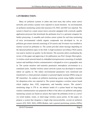
3. HARDWARE ARCHITECTURE:
To satisfy the system’s functional and nonfunctional requirements, two major building
blocks are needed, namely: a Mobile Data-Acquisition Unit (Mobile-DAQ) and a fixed
Internet-Enabled Pollution monitoring Server (Pollution-Server).The Mobile-DAQ unit is
designed by integrating the following hardware modules shown in Fig. 1. As the figure
shows, the Mobile-DAQ consists of a 16-bit single-chip microcontroller integrated with a
sensor array using analog ports. The Mobile-DAQ is also connected to a GPS module and
a GPRS-Modem using the RS-232 interface. Each of these components is described in
the following.
3.1 16-Bit Single-Chip Microcontrollers:-
The microcontroller is a single-chip device that has rich built-in resources for digital
input/output ports, 16 channels, 8/10 bits analog-to-digital converter, 8 input/output
interrupt- driven timers, 12 Kbytes of RAM, 4 Kbytes of EEPROM, 256 Kbytes of
FEEPROM, two RS-232 serial communication ports, 4 Control Area Networks ports,I2C
and SPI communication ports [9]. These resources are more than enough for the proposed
application.
3.2 Sensors Array:-
The sensor array consists of three air pollutions sensors including Carbon Monoxide
(CO), Nitrogen Dioxide (NO2), and Sulfur Dioxide (SO2). As Table I shows, the
resolution of these sensors is sufficient for pollution monitoring. Each of the above
sensors has a linear current output in the range of 4 mA–20 mA. The 4 mA output
corresponds to zero-level gas and the 20 Ma corresponds to the maximum gas level. A
simple signal conditioning circuitwas designed to convert the 4 m A compatible with the
voltage range of the built-in analog-to-digital converter in the 16-bit single chip
microcontroller described earlier.](https://image.slidesharecdn.com/airpollutionmonitoringsystemusingmobilegprssensorsarray-140527073719-phpapp02/85/Air-pollution-monitoring-system-using-mobile-gprs-sensors-array-5-320.jpg)


![Air Pollution Monitoring System Using Mobile GPRS Sensors Array
J.D.I.E.T.Yavatmal. Page 10
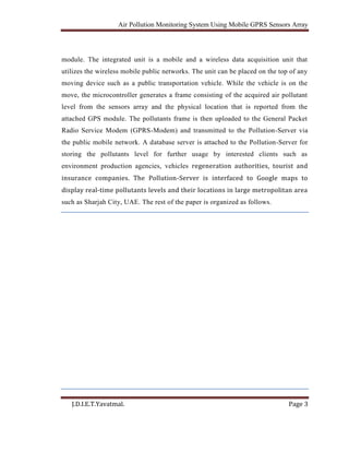
4.4. Data-Frame() function :
Encapsulates the IP address of the Pollution Server, a port number, the three pollutants
levels, latitude and longitude of the sampled location, and time and date of the when the
samples were taken. The data frame is shown in Fig.
4.5.GPRS-Transit() function :
Selectively sends the data frame to the GPRS-Modem using the RS-232 interface N port.
This frame is sent according to the algorithm shown in Fig 2. As the figure shows, a data
frame is only transmitted if the pollutant’s level has changed since the last reading.
The implementation stage consists of three primary modules: Pollution-Server, Air-
Pollution-Index, and Google Mapper. Pollution-Server collects and stores pollutant data
from all the Mobile-DAQs. Air Pollution-Index calculates pollution cate- gories based on
local pollution policies and regulations. Air-Pollution-Index Function to convert the
rawpollutant level received from each Mobile-DAQ to pollution standards called air
quality index (AQI) using the formula [14] .Finally, Google Mapper, makes this pollution
information available over the Internet.
AQI = (
Pollution level
Pollution Standard
) ∗ 100
AI R QUALITY DESCRIPTION](https://image.slidesharecdn.com/airpollutionmonitoringsystemusingmobilegprssensorsarray-140527073719-phpapp02/85/Air-pollution-monitoring-system-using-mobile-gprs-sensors-array-10-320.jpg)

![Air Pollution Monitoring System Using Mobile GPRS Sensors Array
J.D.I.E.T.Yavatmal. Page 12
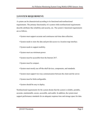
5. IMPLEMENTATION AND TESTING:
The Environment Protection and Safety Section (EPSS) in Dubai has monitored air
quality since 1988 [14]. Their current system is based on six static monitoring stations
located around the Dubai metropolitan area. These stations send air pollutant data to a
central server using fixed line modem connections. The pollution data is also available to
the public through their Web site. This system has worked well. However, the data
collected is limited to the vicinity of the six monitoring stations. Consequently, a mobile
system based on the hardware and software architecture described earlier was built and
tested in the UAE.
The designed sensor array consisting of CO, NO2, and SO2 was interfaced through a
signal conditioning circuit through analogue channels 5, 6, and 7 of the HCS12
microcontroller. The sensor output voltages representing the level of gas for each
pollutant ( ) were converted to a ppm value for each gas. The GPS module was
connected to COM0 and the GPRS-Modem was connected to COM1 of the
microcontroller. Fig.2 shows a typical data frame format being transmitted from
GPRS-Modem to the Pollution-Server. The Mobile-DAQ was mounted on a University
bus that was driven around the campus of the American University of Sharjah (AUS) to
collect pollutant data. The Mobile-DAQ was mounted on top front of the bus to avoid
contamination from the bus exhaust. The pollutant data was collected for 12 h. Fig. 3
shows how a user can use the Internet to access pollutant levels in a location covered by
the bus. As the figure shows, Google Maps is used as the primary interface. Pollutant data
is shown using different coloured polygons that are superimposed on the map. The colour
code used for these polygons was consistent with the AQI index of the Dubai
Municipality. As the figure shows, different areas within the American University of
Sharjah campus have different levels of pollutants. The yellow polygon shows light
pollution while the green polygons show clean air according to the AQI index. As Fig.5
shows, a user can click any of the polygons to retrieve details of the various pollutant
levels. A user can further drill down by clicking to view the past data for any of the gases](https://image.slidesharecdn.com/airpollutionmonitoringsystemusingmobilegprssensorsarray-140527073719-phpapp02/85/Air-pollution-monitoring-system-using-mobile-gprs-sensors-array-12-320.jpg)


![Air Pollution Monitoring System Using Mobile GPRS Sensors Array
J.D.I.E.T.Yavatmal. Page 16
7. REFERENCES:
[1] N. Kularatna and B. H. Sudantha, “An environmental air pollution monitoring
system based on the IEEE 1451 standard for low cost requirements,” IEEE SensorsJ.,
vol. 8, pp. 415– 422, Apr. 2008.
[2] F. Tsow, E Forzani, A. Rai, R. Wang, R. Tsui, S. Mastroianni, CKnobbe, A. J.
Gandolfi, and N. J. Tao, “A wearable and Wireless sensor system for real-time
monitoring of toxic environmental volatile organic compounds,” IEEE Sensors J., vol. 9,
pp. 1734– 1740, Dec. 2009.
[3] Y. J. Jung, Y. K. Lee, D. G. Lee, K. H. Ryu, and S. Nittel, “Air pollution monitoring
system based on geosensor network,” in Proc. IEEE Int Geoscience Remote Sensing
Symp., 2008, vol. 3, pp.1370–1373.
[4] C. J. Wong, M. Z. MatJafri, K. Abdullah, H. S. Lim, and K. L. Low,“Temporal air
quality monitoring using surveillance camera,” in Proc. IEEE Int. Geoscience and
Remote Sensing Symp., 2007, pp.2864–2868.
[5] M. Gao, F. Zhang, and J. Tian, “Environmental monitoring System With wireless
mesh network based on embedded system,” in Proc. 5th IEEE Int. Symp.
Embedded Computing, 2008, pp. 174–179.
[6] W. Chung and C. H. Yang, “Remote monitoring system with wireless sensors module
for room environment,” Sens. Actuators B, vol. 113, no. 1, pp. 35–42, 2009.](https://image.slidesharecdn.com/airpollutionmonitoringsystemusingmobilegprssensorsarray-140527073719-phpapp02/85/Air-pollution-monitoring-system-using-mobile-gprs-sensors-array-16-320.jpg)
Air pollution monitoring system using mobile gprs sensors array
- 1. Air Pollution Monitoring System Using Mobile GPRS Sensors Array J.D.I.E.T.Yavatmal. Page 1 Abstract: This paper contain brief introduction to vehicular pollution, effect of increase in vehicular pollution on environment as well on human health. To monitor this pollution wireless sensor network (WSN) system is proposed. The proposed system consists of a Mobile Data-Acquisition Unit (Mobile-DAQ) and a fixed Internet-Enabled Pollution Monitoring Server (Pollution-Server). The Mobile-DAQ unit integrates a single-chip microcontroller, air pollution sensors array, a General Packet Radio Service Modem (GPRS-Modem), and a Global Positioning System Module (GPS-Module). The Pollution-Server is a high-end personal computer application server with Internet connectivity. The Mobile-DAQ unit gathers air pollutants levels (CO, NO2, and SO2), and packs them in a frame with the GPS physical location, time, and date. The frame is subsequently uploaded to the GPRS-Modem and transmitted to the Pollution-Server via the public mobile network. A database server is attached to the Pollution- Server for storing the pollutants level for further usage by various clients such as environment protection agencies, vehicles registration authorities, and tourist and insurance companies.
- 2. Air Pollution Monitoring System Using Mobile GPRS Sensors Array J.D.I.E.T.Yavatmal. Page 2 1.INTRODUCTION: Many air pollution systems in urban and rural areas that utilize smart sensor networks and wireless systems were reported in recent literature. An environmental air pollution monitoring system that measures CO, NO2, and SO2 was reported. The system is based on a smart sensor micro converter equipped with a network capable application processor that downloads the pollutants level to a personal computer for further processing. A wearable and wireless sensor system for real-time monitoring of toxic environmental volatile organic compounds was developed in. An air pollution geo-sensor network consisting of 24 sensors and 10 routers was installed to monitor several air pollutants in. The system provides alarm message depending on the detected pollution types in the field. A high-resolution surveillance Web-camera was used to monitor air quality via the Internet. The associate editor coordinating the review of this paper and approving it for publication was Prof. Giorgio Sberveglieri. A wireless mesh network based on embedded microprocessors consisting of multiple sensors and multihop wireless communication is designed to cover a geographic area in. The system monitors and transmits parameters atmospheric environment to a command center. Another wireless sensor network system was developed to monitor indoor air quality in. The indoor environmental parameters were monitored and transferred to a client personal computer or personal digital assistant (PDA) using an RF transmitter. An outdoor air pollution monitoring system using ZigBee networks for ubiquitous-cities was reported in. The system integrates a wireless sensor board which employs dust, CO2, temperature, and humidity sensors. The system’s monitoring range is 270 m. An abstract model of a system based on long-range wireless communication was proposed in.Most of the above air pollution and quality monitoring systems are based on sensors that report the pollutants levels to a server via wired modem, router, or short-range wireless access points. In this paper, we propose a system that integrates a single-chip microcontroller, several air pollution sensors (CO, NO2, SO2), GPRS-Modem, and a general positioning systems (GPSs)
- 3. Air Pollution Monitoring System Using Mobile GPRS Sensors Array J.D.I.E.T.Yavatmal. Page 3 module. The integrated unit is a mobile and a wireless data acquisition unit that utilizes the wireless mobile public networks. The unit can be placed on the top of any moving device such as a public transportation vehicle. While the vehicle is on the move, the microcontroller generates a frame consisting of the acquired air pollutant level from the sensors array and the physical location that is reported from the attached GPS module. The pollutants frame is then uploaded to the General Packet Radio Service Modem (GPRS-Modem) and transmitted to the Pollution-Server via the public mobile network. A database server is attached to the Pollution-Server for storing the pollutants level for further usage by interested clients such as environment production agencies, vehicles regeneration authorities, tourist and insurance companies. The Pollution-Server is interfaced to Google maps to display real-time pollutants levels and their locations in large metropolitan area such as Sharjah City, UAE. The rest of the paper is organized as follows.
- 4. Air Pollution Monitoring System Using Mobile GPRS Sensors Array J.D.I.E.T.Yavatmal. Page 4 2.SYSTEM REQUIRMENT: A system can be characterized according to its functional and nonfunctional requirements. The primary functionality of a system while nonfunctional requirements describe attributes like reliability and security, etc. The system’s functional requirements are as follows. • System must support accurate and continuous real-time data collection. • System needs to store the data and provide access to a location map interface. • System needs to support mobility. • System must use minimum power. • System must be accessible from the Internet 24/7. • System must be compact. • System must mostly use off-the-shelf devices, components, and standards. • System must support two-way communication between the client and the server. • System must be field-configurable. • System should be easy to deploy. Nonfunctional requirements for the system dictate that the system is reliable, portable, accurate, maintainable, secure, accessible, and usable. In addition, the system must support performance standards for an adequate response time and storage space for data.
- 5. Air Pollution Monitoring System Using Mobile GPRS Sensors Array J.D.I.E.T.Yavatmal. Page 5 3. HARDWARE ARCHITECTURE: To satisfy the system’s functional and nonfunctional requirements, two major building blocks are needed, namely: a Mobile Data-Acquisition Unit (Mobile-DAQ) and a fixed Internet-Enabled Pollution monitoring Server (Pollution-Server).The Mobile-DAQ unit is designed by integrating the following hardware modules shown in Fig. 1. As the figure shows, the Mobile-DAQ consists of a 16-bit single-chip microcontroller integrated with a sensor array using analog ports. The Mobile-DAQ is also connected to a GPS module and a GPRS-Modem using the RS-232 interface. Each of these components is described in the following. 3.1 16-Bit Single-Chip Microcontrollers:- The microcontroller is a single-chip device that has rich built-in resources for digital input/output ports, 16 channels, 8/10 bits analog-to-digital converter, 8 input/output interrupt- driven timers, 12 Kbytes of RAM, 4 Kbytes of EEPROM, 256 Kbytes of FEEPROM, two RS-232 serial communication ports, 4 Control Area Networks ports,I2C and SPI communication ports [9]. These resources are more than enough for the proposed application. 3.2 Sensors Array:- The sensor array consists of three air pollutions sensors including Carbon Monoxide (CO), Nitrogen Dioxide (NO2), and Sulfur Dioxide (SO2). As Table I shows, the resolution of these sensors is sufficient for pollution monitoring. Each of the above sensors has a linear current output in the range of 4 mA–20 mA. The 4 mA output corresponds to zero-level gas and the 20 Ma corresponds to the maximum gas level. A simple signal conditioning circuitwas designed to convert the 4 m A compatible with the voltage range of the built-in analog-to-digital converter in the 16-bit single chip microcontroller described earlier.
- 6. Air Pollution Monitoring System Using Mobile GPRS Sensors Array J.D.I.E.T.Yavatmal. Page 6 Fig 1. system hardware basic building blocks
- 7. Air Pollution Monitoring System Using Mobile GPRS Sensors Array J.D.I.E.T.Yavatmal. Page 7 3.3 GPS Module:- The GPS module provides the physical coordinate location of the mobile-DAQ, time and date in National Marine Electronics Association (NMEA) format .NEMA format includes the complete position, velocity, and time computed by a GPS receiver where the position The data packet from the GPS-Module includes an RMS Header followed by UTC time, data validity checksum, latitude, longitude, velocity, heading, date, magnetic variation and direction, mode, and checksum. The only information required for the proposed system is date, time, latitude and longitude. The GPS modem is interfaced with the microcontroller using the RS-232 communication standard. 3.4 GPRS-Modem:- The general packet radio service (GPRS) is a packet-oriented mobile data service used in 2G and 3G cellular communication systems global system for mobile communications (GSM).The proposed system uses a GPRS-Modem as a communication device to transmit time, date, physical location and level of air pollutants. The modem used for the proposed system has an embedded communication protocol that supports Machine-to- Machine (M2M) intelligent wireless Transmission Control Protocol (TCP/IP) features such as Simple Mail Transfer (SMTP) E-mail, File Transfer Protocol (FTP), and Simple Messaging Service (SMS) services Protocol. The modem supports an RS-232 interface that allows Serial TCP/IP socket tunneling. The modem also has rugged aluminum enclosure making it suitable for the proposed system. 3.5 Pollution-Server:- The Pollution-Server is an off-the-shelf standard personal computer with accessibility to the Internet. As Fig. 1 shows, the Pollution-Server connects to the GPRS-Modem via TCP/IP through the Internet and the public mobile network. The server requires a private IP address for the GPRS-Modem and communicates over a pre-configured port. The
- 8. Air Pollution Monitoring System Using Mobile GPRS Sensors Array J.D.I.E.T.Yavatmal. Page 8 Pollution-Server connects to a database management system (MySQL) through a local area network (LAN). The Pollution-Server runs a WampServer stackthat provides the Apache Web Server in addition to the PHP Servermunicipality,environmental protection agencies, travel agencies, insurance companies and tourist companies can connect to the Pollution-Server through the Internet and check the real-time air pollutants level using a normal browser on a standard PC or a mobile device. The Pollution-Server can be physically located at the Environmental Protection Agency (EPA) or similar government agencies.Environmental protection agencies, travel agencies, insurance companies and tourist companies can connect to the Pollution-Server through the Internet and check the real-time air pollutants level using a normal browser on a standard PC or a mobile device. The Pollution-Server can be physically located at the Environmental Protection Agency (EPA) or similar government agencies. Fig.2. Data-frame format
- 9. Air Pollution Monitoring System Using Mobile GPRS Sensors Array J.D.I.E.T.Yavatmal. Page 9 4. SOFTWARE DESIGN: The system software architecture is having five different functions. This function is responsible for acquiring the real-time data from the sensors-array and the physical location, time and date of the sampled pollutants from the GPS module. This information is then encapsulated into a data frame by the microcontroller. The microcontroller then sends each frame to the GPRS-Modem through the RS-232 interface. The GPRS-Modem, in turn, sends each data frame to the Pollution-Server using the publicly available mobile network and the Internet. The physical layer is implemented using ANSI C language which is compiled to native microcontroller code. The software implementing the physical layer is composed of five functions,namely:PortsRead()function,Sensor-Acquisition()function,GPS-Read()function, Data-Frame() function, and GPRS-Transit()function. Are called from a main program that is stored on and executed by the Mobile-DAQ microcontroller. 4.1.Ports-Read()function : Developed to configure the digital inputs/outputs in addition to the resolution of the analog-to-digital converters that read the air pollutants level from sensor array outputs. 4.2.Sensor-Acquisition ()function: Reads each pollutant level as a voltage from the signal conditioning circuit output via the built-in analog-to-digital converter module of the microcontroller. 4.3.GPS-Read()function : Communicates with the GPS module through RS-232 and extracts latitude and longitude of the sampled air pollutant along with time and the date.
- 10. Air Pollution Monitoring System Using Mobile GPRS Sensors Array J.D.I.E.T.Yavatmal. Page 10 4.4. Data-Frame() function : Encapsulates the IP address of the Pollution Server, a port number, the three pollutants levels, latitude and longitude of the sampled location, and time and date of the when the samples were taken. The data frame is shown in Fig. 4.5.GPRS-Transit() function : Selectively sends the data frame to the GPRS-Modem using the RS-232 interface N port. This frame is sent according to the algorithm shown in Fig 2. As the figure shows, a data frame is only transmitted if the pollutant’s level has changed since the last reading. The implementation stage consists of three primary modules: Pollution-Server, Air- Pollution-Index, and Google Mapper. Pollution-Server collects and stores pollutant data from all the Mobile-DAQs. Air Pollution-Index calculates pollution cate- gories based on local pollution policies and regulations. Air-Pollution-Index Function to convert the rawpollutant level received from each Mobile-DAQ to pollution standards called air quality index (AQI) using the formula [14] .Finally, Google Mapper, makes this pollution information available over the Internet. AQI = ( Pollution level Pollution Standard ) ∗ 100 AI R QUALITY DESCRIPTION
- 11. Air Pollution Monitoring System Using Mobile GPRS Sensors Array J.D.I.E.T.Yavatmal. Page 11 Fig. 2.Mobile-DAQ software algorithm.
- 12. Air Pollution Monitoring System Using Mobile GPRS Sensors Array J.D.I.E.T.Yavatmal. Page 12 5. IMPLEMENTATION AND TESTING: The Environment Protection and Safety Section (EPSS) in Dubai has monitored air quality since 1988 [14]. Their current system is based on six static monitoring stations located around the Dubai metropolitan area. These stations send air pollutant data to a central server using fixed line modem connections. The pollution data is also available to the public through their Web site. This system has worked well. However, the data collected is limited to the vicinity of the six monitoring stations. Consequently, a mobile system based on the hardware and software architecture described earlier was built and tested in the UAE. The designed sensor array consisting of CO, NO2, and SO2 was interfaced through a signal conditioning circuit through analogue channels 5, 6, and 7 of the HCS12 microcontroller. The sensor output voltages representing the level of gas for each pollutant ( ) were converted to a ppm value for each gas. The GPS module was connected to COM0 and the GPRS-Modem was connected to COM1 of the microcontroller. Fig.2 shows a typical data frame format being transmitted from GPRS-Modem to the Pollution-Server. The Mobile-DAQ was mounted on a University bus that was driven around the campus of the American University of Sharjah (AUS) to collect pollutant data. The Mobile-DAQ was mounted on top front of the bus to avoid contamination from the bus exhaust. The pollutant data was collected for 12 h. Fig. 3 shows how a user can use the Internet to access pollutant levels in a location covered by the bus. As the figure shows, Google Maps is used as the primary interface. Pollutant data is shown using different coloured polygons that are superimposed on the map. The colour code used for these polygons was consistent with the AQI index of the Dubai Municipality. As the figure shows, different areas within the American University of Sharjah campus have different levels of pollutants. The yellow polygon shows light pollution while the green polygons show clean air according to the AQI index. As Fig.5 shows, a user can click any of the polygons to retrieve details of the various pollutant levels. A user can further drill down by clicking to view the past data for any of the gases
- 13. Air Pollution Monitoring System Using Mobile GPRS Sensors Array J.D.I.E.T.Yavatmal. Page 13 for this location. For example, Fig.6 shows the history of CO pollutant for the last seven readings over an 8 h period for a given day. Fig 3. Details of pollutant data Fig. 4. History of CO pollutant
- 14. Air Pollution Monitoring System Using Mobile GPRS Sensors Array J.D.I.E.T.Yavatmal. Page 14 Fig 5. Google Mapper data
- 15. Air Pollution Monitoring System Using Mobile GPRS Sensors Array J.D.I.E.T.Yavatmal. Page 15 6.CONCLUSION: The proposed Wireless Air Pollution Monitoring System provides real-time information about the level of air pollution in these regions, as well as provides alerts in cases of drastic change in quality of air. This information can then be used by the authorities to take prompt actions such as evacuating people or sending emergency response team.A wireless distributed mobile air pollution monitoring system was implemented using the GPRS public network along with GPS. The system utilizes city buses to collect pollutant gases such as CO, NO2, and SO2. The pollution data from various mobile sensor arrays is transmitted to a central several that make this data available on the Internet through a Google Maps interface. The data shows the pollutant levels and their conformance to local air quality standards.
- 16. Air Pollution Monitoring System Using Mobile GPRS Sensors Array J.D.I.E.T.Yavatmal. Page 16 7. REFERENCES: [1] N. Kularatna and B. H. Sudantha, “An environmental air pollution monitoring system based on the IEEE 1451 standard for low cost requirements,” IEEE SensorsJ., vol. 8, pp. 415– 422, Apr. 2008. [2] F. Tsow, E Forzani, A. Rai, R. Wang, R. Tsui, S. Mastroianni, CKnobbe, A. J. Gandolfi, and N. J. Tao, “A wearable and Wireless sensor system for real-time monitoring of toxic environmental volatile organic compounds,” IEEE Sensors J., vol. 9, pp. 1734– 1740, Dec. 2009. [3] Y. J. Jung, Y. K. Lee, D. G. Lee, K. H. Ryu, and S. Nittel, “Air pollution monitoring system based on geosensor network,” in Proc. IEEE Int Geoscience Remote Sensing Symp., 2008, vol. 3, pp.1370–1373. [4] C. J. Wong, M. Z. MatJafri, K. Abdullah, H. S. Lim, and K. L. Low,“Temporal air quality monitoring using surveillance camera,” in Proc. IEEE Int. Geoscience and Remote Sensing Symp., 2007, pp.2864–2868. [5] M. Gao, F. Zhang, and J. Tian, “Environmental monitoring System With wireless mesh network based on embedded system,” in Proc. 5th IEEE Int. Symp. Embedded Computing, 2008, pp. 174–179. [6] W. Chung and C. H. Yang, “Remote monitoring system with wireless sensors module for room environment,” Sens. Actuators B, vol. 113, no. 1, pp. 35–42, 2009.