SlideShare a Scribd company logo
Analysis of Remote Sensing Quantitative Inversion  in Cloud Computing Jing Dong , Yong Xue, Ziqiang Chen, Hui Xu, Yingjie Li Institute of Remote Sensing Applications Chinese Academy of Sciences  July 29, 2011
Aerosol Optical Depth(AOD) Retrieval High Performance Computing Institute of Remote Sensing Application, CAS
Outline An Introduction of Cloud Computing Remote Sensing Quantitative Inversion & Cloud Computing A Possible Cloud In Remote Sensing Quantitative Inversion Discussion  and Future Work 1 Institute of Remote Sensing Application, CAS
Introduction What is Cloud Computing What can Cloud Computing do How does Cloud Computing work 2 Institute of Remote Sensing Application, CAS
Introduction 3 SaaS IaaS PaaS DaaS Software as a Service Infrastructure as a Service Platform as a Service Data as a Service Institute of Remote Sensing Application, CAS A large-scale distributed computing paradigm that is driven by economies of scale, in which a pool of abstracted, virtualized, dynamically-scalable, managed  computing power, storage, platforms, and services are delivered on demand to external customers over the Internet.  —— Foster et al.(2008)
Introduction- cloud   products Amazon Elastic Compute Cloud (Amazon EC2) of  Amazon 、 Windows Azure of  Microsoft 、 Google App Engine of  Google 、 Blue Cloud of  IBM 4 Institute of Remote Sensing Application, CAS
Remote Sensing Quantitative Inversion  & Cloud Computing Charge eg.  Amazon EC2 Technical Support eg. Google App Engine Security computing infrastructure maintained  and controlled by third parties  5 Institute of Remote Sensing Application, CAS
An example- Charge Application—remote sensing quantitative inversion Data Resource  : MODIS for one year Range : over China total volume: 2.97TB (2008) per day: 8.4GB 6 Institute of Remote Sensing Application, CAS
Charge Standard of Amazon  in US dollars-data transfer 7 Institute of Remote Sensing Application, CAS nearly 304.13 US dollars
An example- Charge Data Resource  : MODIS for one year Range : over China total volume: 2.97TB per day: 8.4GB processing time of geometric correction(GC) 8 Institute of Remote Sensing Application, CAS
Charge Standard of Amazon  in US dollars 9 The price of on-demand instances Institute of Remote Sensing Application, CAS at least 832.2 US dollars
An example- Cost Data transfer in— nearly 304.13 US dollars  for the whole year of 2008 Instance rent for GC— at least 832.2 US dollars for one year data The cost is so high 10 Institute of Remote Sensing Application, CAS
An example - Technical Support Google App Engine  Java  python  most of the quantitative remote sensing inversion algorithms  IDL  C++ 11 Institute of Remote Sensing Application, CAS
Security Data Security Network connection Emergency breakdown in 2008 and 2011 service closed 12 Institute of Remote Sensing Application, CAS
A Possible Cloud 13 Advantage:  avoid high cost for data transfer Disadvantage:  not suitable for multi-source data comprehensive applications Institute of Remote Sensing Application, CAS
Discussions and Future Work Cloud computing would not necessarily suitable for all scientific applications, especially for geoscience Standardized metadata management mechanism, more efficient data storage and sharing method, and more reliable security mechanism are needed Institute of Remote Sensing Application, CAS 14
Jing Dong Email:  [email_address] URL:  www.tgp.ac.cn

More Related Content

PDF
CloudLightning at a Glance Infographic
PPTX
Health & Status Monitoring (2010-v8)
PDF
Spark for Behavioral Analytics Research: Spark Summit East talk by John W u
PDF
IRJET- Secure Data Access on Distributed Database using Skyline Queries
PPTX
OCC Overview OMG Clouds Meeting 07-13-09 v3
PPTX
Planet lab : cloud vs grid computing
PPTX
Bioclouds CAMDA (Robert Grossman) 09-v9p
PPTX
Open Science Data Cloud - CCA 11
CloudLightning at a Glance Infographic
Health & Status Monitoring (2010-v8)
Spark for Behavioral Analytics Research: Spark Summit East talk by John W u
IRJET- Secure Data Access on Distributed Database using Skyline Queries
OCC Overview OMG Clouds Meeting 07-13-09 v3
Planet lab : cloud vs grid computing
Bioclouds CAMDA (Robert Grossman) 09-v9p
Open Science Data Cloud - CCA 11

What's hot (20)

PPTX
Bionimbus Cambridge Workshop (3-28-11, v7)
PPTX
Open Science Data Cloud (IEEE Cloud 2011)
PPTX
Stanford/SLAC Cryo-EM Computing and Storage, Yee-Ting Li
PPT
Large Scale On-Demand Image Processing For Disaster Relief
PPT
PPTX
Project Matsu: Elastic Clouds for Disaster Relief
PDF
What Are Science Clouds?
PPTX
Big Data, Big Computing, AI, and Environmental Science
PPTX
London data science
PDF
The Matsu Project - Open Source Software for Processing Satellite Imagery Data
PDF
The Open Science Data Cloud: Empowering the Long Tail of Science
PPT
B4 greengrid
DOCX
A TIME EFFICIENT APPROACH FOR DETECTING ERRORS IN BIG SENSOR DATA ON CLOUD
PPTX
DATACUBES: Conquering Space & Time
PPTX
Slide 1
PPTX
Learning Systems for Science
PDF
An introduction to Workload Modelling for Cloud Applications
PPTX
Foster CRA March 2022.pptx
PPT
Cybera -Projects 2010
Bionimbus Cambridge Workshop (3-28-11, v7)
Open Science Data Cloud (IEEE Cloud 2011)
Stanford/SLAC Cryo-EM Computing and Storage, Yee-Ting Li
Large Scale On-Demand Image Processing For Disaster Relief
Project Matsu: Elastic Clouds for Disaster Relief
What Are Science Clouds?
Big Data, Big Computing, AI, and Environmental Science
London data science
The Matsu Project - Open Source Software for Processing Satellite Imagery Data
The Open Science Data Cloud: Empowering the Long Tail of Science
B4 greengrid
A TIME EFFICIENT APPROACH FOR DETECTING ERRORS IN BIG SENSOR DATA ON CLOUD
DATACUBES: Conquering Space & Time
Slide 1
Learning Systems for Science
An introduction to Workload Modelling for Cloud Applications
Foster CRA March 2022.pptx
Cybera -Projects 2010
Ad

Similar to Analysis_of_Remote_Sensing_Quantitative_Inversion_in_Cloud_Computing.ppt (20)

PDF
GIS in the Cloud
PDF
Gis In The Cloud
PDF
Cloud computing - Terena 2011
PDF
Cloud Computing - Challenges and Opportunities - Jens Nimis
PDF
lecture02_Cloud Computer Basicsrwrwrwrwr
PDF
50120140502008
PPTX
GIS & Cloud Computing - GAASC 2010 Fall Summit - Florence, SC
PDF
New Trends of Geospatial Services on AWS Cloud - Channy Yun :: ICGIS 2015 Seoul
PDF
A Brief Introducton to Cloud Computing
PDF
Kentucky gis
PPT
Exploring Cloud Computing Technologies For GIS (Location Based) Applications
PDF
Cloud Computing: On the Air or Down to Earth - Beneficios para la Empresa
PDF
ClassCloud: switch your PC Classroom into Cloud Testbed
PPTX
ACES QuakeSim 2011
PDF
Infrastructure of services for a smart city
PDF
About clouds
PDF
Cloud Computing Tutorial - Jens Nimis
PDF
remotesensing-12-01253.pdf
PDF
Esri South Africa GIS In The Cloud
PPTX
Improving access to satellite imagery with Cloud computing
GIS in the Cloud
Gis In The Cloud
Cloud computing - Terena 2011
Cloud Computing - Challenges and Opportunities - Jens Nimis
lecture02_Cloud Computer Basicsrwrwrwrwr
50120140502008
GIS & Cloud Computing - GAASC 2010 Fall Summit - Florence, SC
New Trends of Geospatial Services on AWS Cloud - Channy Yun :: ICGIS 2015 Seoul
A Brief Introducton to Cloud Computing
Kentucky gis
Exploring Cloud Computing Technologies For GIS (Location Based) Applications
Cloud Computing: On the Air or Down to Earth - Beneficios para la Empresa
ClassCloud: switch your PC Classroom into Cloud Testbed
ACES QuakeSim 2011
Infrastructure of services for a smart city
About clouds
Cloud Computing Tutorial - Jens Nimis
remotesensing-12-01253.pdf
Esri South Africa GIS In The Cloud
Improving access to satellite imagery with Cloud computing
Ad

More from grssieee (20)

PDF
Tangent height accuracy of Superconducting Submillimeter-Wave Limb-Emission S...
PDF
SEGMENTATION OF POLARIMETRIC SAR DATA WITH A MULTI-TEXTURE PRODUCT MODEL
PPTX
TWO-POINT STATISTIC OF POLARIMETRIC SAR DATA TWO-POINT STATISTIC OF POLARIMET...
PPT
THE SENTINEL-1 MISSION AND ITS APPLICATION CAPABILITIES
PPTX
GMES SPACE COMPONENT:PROGRAMMATIC STATUS
PPTX
PROGRESSES OF DEVELOPMENT OF CFOSAT SCATTEROMETER
PPT
DEVELOPMENT OF ALGORITHMS AND PRODUCTS FOR SUPPORTING THE ITALIAN HYPERSPECTR...
PPT
EO-1/HYPERION: NEARING TWELVE YEARS OF SUCCESSFUL MISSION SCIENCE OPERATION A...
PPT
EO-1/HYPERION: NEARING TWELVE YEARS OF SUCCESSFUL MISSION SCIENCE OPERATION A...
PPT
EO-1/HYPERION: NEARING TWELVE YEARS OF SUCCESSFUL MISSION SCIENCE OPERATION A...
PDF
Test
PPT
test 34mb wo animations
PPT
Test 70MB
PPT
Test 70MB
PDF
2011_Fox_Tax_Worksheets.pdf
PPT
DLR open house
PPT
DLR open house
PPT
DLR open house
PPT
Tana_IGARSS2011.ppt
PPT
Solaro_IGARSS_2011.ppt
Tangent height accuracy of Superconducting Submillimeter-Wave Limb-Emission S...
SEGMENTATION OF POLARIMETRIC SAR DATA WITH A MULTI-TEXTURE PRODUCT MODEL
TWO-POINT STATISTIC OF POLARIMETRIC SAR DATA TWO-POINT STATISTIC OF POLARIMET...
THE SENTINEL-1 MISSION AND ITS APPLICATION CAPABILITIES
GMES SPACE COMPONENT:PROGRAMMATIC STATUS
PROGRESSES OF DEVELOPMENT OF CFOSAT SCATTEROMETER
DEVELOPMENT OF ALGORITHMS AND PRODUCTS FOR SUPPORTING THE ITALIAN HYPERSPECTR...
EO-1/HYPERION: NEARING TWELVE YEARS OF SUCCESSFUL MISSION SCIENCE OPERATION A...
Test
test 34mb wo animations
Test 70MB
Test 70MB
2011_Fox_Tax_Worksheets.pdf
DLR open house
DLR open house
DLR open house
Tana_IGARSS2011.ppt
Solaro_IGARSS_2011.ppt

Recently uploaded (20)

DOCX
The AUB Centre for AI in Media Proposal.docx
PDF
Approach and Philosophy of On baking technology
PDF
Reach Out and Touch Someone: Haptics and Empathic Computing
PPTX
sap open course for s4hana steps from ECC to s4
PDF
Unlocking AI with Model Context Protocol (MCP)
PPTX
Big Data Technologies - Introduction.pptx
PPT
“AI and Expert System Decision Support & Business Intelligence Systems”
PDF
Building Integrated photovoltaic BIPV_UPV.pdf
PDF
Blue Purple Modern Animated Computer Science Presentation.pdf.pdf
PDF
Encapsulation_ Review paper, used for researhc scholars
PDF
Dropbox Q2 2025 Financial Results & Investor Presentation
PDF
Review of recent advances in non-invasive hemoglobin estimation
PPTX
MYSQL Presentation for SQL database connectivity
PPTX
Cloud computing and distributed systems.
PPTX
ACSFv1EN-58255 AWS Academy Cloud Security Foundations.pptx
PDF
Build a system with the filesystem maintained by OSTree @ COSCUP 2025
PDF
Machine learning based COVID-19 study performance prediction
PPTX
Machine Learning_overview_presentation.pptx
PPTX
Spectroscopy.pptx food analysis technology
PDF
Peak of Data & AI Encore- AI for Metadata and Smarter Workflows
The AUB Centre for AI in Media Proposal.docx
Approach and Philosophy of On baking technology
Reach Out and Touch Someone: Haptics and Empathic Computing
sap open course for s4hana steps from ECC to s4
Unlocking AI with Model Context Protocol (MCP)
Big Data Technologies - Introduction.pptx
“AI and Expert System Decision Support & Business Intelligence Systems”
Building Integrated photovoltaic BIPV_UPV.pdf
Blue Purple Modern Animated Computer Science Presentation.pdf.pdf
Encapsulation_ Review paper, used for researhc scholars
Dropbox Q2 2025 Financial Results & Investor Presentation
Review of recent advances in non-invasive hemoglobin estimation
MYSQL Presentation for SQL database connectivity
Cloud computing and distributed systems.
ACSFv1EN-58255 AWS Academy Cloud Security Foundations.pptx
Build a system with the filesystem maintained by OSTree @ COSCUP 2025
Machine learning based COVID-19 study performance prediction
Machine Learning_overview_presentation.pptx
Spectroscopy.pptx food analysis technology
Peak of Data & AI Encore- AI for Metadata and Smarter Workflows

Analysis_of_Remote_Sensing_Quantitative_Inversion_in_Cloud_Computing.ppt

  • 1. Analysis of Remote Sensing Quantitative Inversion in Cloud Computing Jing Dong , Yong Xue, Ziqiang Chen, Hui Xu, Yingjie Li Institute of Remote Sensing Applications Chinese Academy of Sciences July 29, 2011
  • 2. Aerosol Optical Depth(AOD) Retrieval High Performance Computing Institute of Remote Sensing Application, CAS
  • 3. Outline An Introduction of Cloud Computing Remote Sensing Quantitative Inversion & Cloud Computing A Possible Cloud In Remote Sensing Quantitative Inversion Discussion and Future Work 1 Institute of Remote Sensing Application, CAS
  • 4. Introduction What is Cloud Computing What can Cloud Computing do How does Cloud Computing work 2 Institute of Remote Sensing Application, CAS
  • 5. Introduction 3 SaaS IaaS PaaS DaaS Software as a Service Infrastructure as a Service Platform as a Service Data as a Service Institute of Remote Sensing Application, CAS A large-scale distributed computing paradigm that is driven by economies of scale, in which a pool of abstracted, virtualized, dynamically-scalable, managed computing power, storage, platforms, and services are delivered on demand to external customers over the Internet. —— Foster et al.(2008)
  • 6. Introduction- cloud products Amazon Elastic Compute Cloud (Amazon EC2) of Amazon 、 Windows Azure of Microsoft 、 Google App Engine of Google 、 Blue Cloud of IBM 4 Institute of Remote Sensing Application, CAS
  • 7. Remote Sensing Quantitative Inversion & Cloud Computing Charge eg. Amazon EC2 Technical Support eg. Google App Engine Security computing infrastructure maintained and controlled by third parties 5 Institute of Remote Sensing Application, CAS
  • 8. An example- Charge Application—remote sensing quantitative inversion Data Resource : MODIS for one year Range : over China total volume: 2.97TB (2008) per day: 8.4GB 6 Institute of Remote Sensing Application, CAS
  • 9. Charge Standard of Amazon in US dollars-data transfer 7 Institute of Remote Sensing Application, CAS nearly 304.13 US dollars
  • 10. An example- Charge Data Resource : MODIS for one year Range : over China total volume: 2.97TB per day: 8.4GB processing time of geometric correction(GC) 8 Institute of Remote Sensing Application, CAS
  • 11. Charge Standard of Amazon in US dollars 9 The price of on-demand instances Institute of Remote Sensing Application, CAS at least 832.2 US dollars
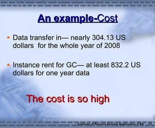
  • 12. An example- Cost Data transfer in— nearly 304.13 US dollars for the whole year of 2008 Instance rent for GC— at least 832.2 US dollars for one year data The cost is so high 10 Institute of Remote Sensing Application, CAS
  • 13. An example - Technical Support Google App Engine Java python most of the quantitative remote sensing inversion algorithms IDL C++ 11 Institute of Remote Sensing Application, CAS
  • 14. Security Data Security Network connection Emergency breakdown in 2008 and 2011 service closed 12 Institute of Remote Sensing Application, CAS
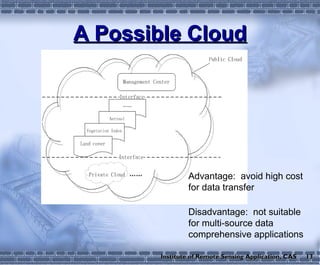
  • 15. A Possible Cloud 13 Advantage: avoid high cost for data transfer Disadvantage: not suitable for multi-source data comprehensive applications Institute of Remote Sensing Application, CAS
  • 16. Discussions and Future Work Cloud computing would not necessarily suitable for all scientific applications, especially for geoscience Standardized metadata management mechanism, more efficient data storage and sharing method, and more reliable security mechanism are needed Institute of Remote Sensing Application, CAS 14
  • 17. Jing Dong Email: [email_address] URL: www.tgp.ac.cn

Editor's Notes