SlideShare a Scribd company logo
NSDI Initiative – Policies and Data Standards
PS Acharya, CEO, NSDI
NRDMS-NSDI Division, DST, New Delhi
NeGD, DeitY organized Thematic Workshop on
"Use of GIS in Informed Planning And Decision Making“
Indian Habitat Centre, Lodi Road, New Delhi
29 March 2016
NSDI Vision and objectives
 National infrastructure for the availability of and access
to organized spatial data
 Use of the infrastructure at Community, Local, State,
Regional and National levels for sustainable development
Vision
Objectives
 Develop and maintain standard digital collection of data
 Develop common solutions for Discovery, Access and Use of
spatial data in response to the needs of diverse user groups
 Increase the awareness & understanding of the vision,
concepts and benefits of the NSDI
Current Problems
• Sheetwise storage of
metadata as against feature data
• No service metadata accessible
(e.g. WMS/ WFS etc.)
• Catalogue service unavailable
• Querying on visualisation/ web map service
absent
• Content standard for ‘soil’ is available or getting
developed on other themes but not in a machine-
readable standard form (GML Application schema)
• Metadata not accessible in machine readable
form (XML)
• Nodes for GIS Data Assets from providing
agencies not operational
(metadata search display)
(Display of result of navigation query
Using IndoorGML)
• National Geospatial Policy, National Survey Act, State SDI Policies,
Empowered SOI Committee, Technical Committee on NATMO
• Co-branded BIS standards, Geology/ Forest/ Soil Data Specifications
• National Foundation Spatial Data WFS and 1:50K countrywide WMS
through National Data Portal (data.gov.in)
• Admin. Boundary data harmonization Committee – SOI, Census,
NRSC, NIC, MoSPI, HARSAC
• Smart City Data by NATMO as WMS/ WFS, Mahakashi Data (1:5K,
1:10K), CityGML/ IndoorGML
• UniqueIDs for parcels and flat properties for DoLR
• Data Registry Prototype
• NSDI Road Map – NGIS Deliverables
Recent Progress Outline as of March 2016
Policies/ Important Decisions
• National Map Policy, 2005
• NSDI Resolution, 2006
• State Chief Secretaries Conference, Feb
2011
• National Remote Sensing Policy, 2011
• National Mirror Committee for ISO TC
211 by BIS
• National Data Sharing & Accessibility
Policy, 2012
• State Data Sharing Policies (Delhi, MP,
Odisha)
• National Geo-spatial Information Policy
(being drafted)
NDSAP - Highlights
• ‘Proactive’ instead
of ‘reactive’ sharing
• Mandatory sharing of all
data generated through public
funds except on national security
considerations
• Publication of ‘Exclusion
or Negative List’
• Four Types of Accesses
(open, automatic registered,
authorised registered,
restricted e.g. G2G)
NSDI policies and data initiatives - Dr. P.S. Acharya
End User/
Decision-maker
(Stakeholders) Data Providers
(Shareholders)
User/ Web
applications Bind
Publish
Find
Catalogues,
National Data
Registry (NDR)
Databases (Oracle Spatial,
Shape files, DGN files, raster
files etc.)
Service-oriented Architecture
Difficulties in sharing data between databases
• Different rules for object’s categorization and
definition (semantic heterogeneity)
• Different data models and data structures (schematic
heterogeneity)
• Data collection, processing, presentation in
different standards/ methods, different GIS
platforms (syntactic heterogeneity)
• Different institutional constraints (data access, rights
of use, costs etc.)
Approved ISO/ OGC Specifications deployed
(Indicative)
• Data Metadata (ISO 19115) (NSDI Metadata
version 2.0)
• Geography Markup Language (GML) (ISO 19136)
• Web Feature Service (WFS) (ISO 19142)
• Web Map Service (WMS) (ISO 19128)
• Conceptual Schema Language (ISO 19103)
• Rules for application schema (ISO 19109)
• Catalogue Service on Web (CSW)
• Style Layer Descriptor (SLD)
NSDI policies and data initiatives - Dr. P.S. Acharya
Different Tiers of Standards for GI Management
(Source: UNGGIM Draft prepared by ISO, OGC, and IHO)
NSDI policies and data initiatives - Dr. P.S. Acharya
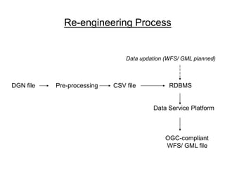
DGN file Pre-processing CSV file RDBMS
Data Service Platform
OGC-compliant
WFS/ GML file
Data updation (WFS/ GML planned)
Re-engineering Process
NSDI policies and data initiatives - Dr. P.S. Acharya
UML Class Diagram from Data Content on Surface Geology
Source: GSI
UML Class Diagram from Data Content on Forest
Source: FSI
• Kerala Geoportal
(www.keralaspatialdatabase.org)
• Karnataka Geoportal
(www.karanatakageoportal.in)
• North East SDI Geoportal
(agnee.tezu.ernet.in:8004/nesdi)
• Other State SDI projects under
implementation (West Bengal,
Haryana, Uttarakhand, J & K,
Odisha)
State SDI Initiative
Viewing of uploaded image by registered user
KSCST,KSSDI,NRDMS, IISc, Bangalore-12
NSDI policies and data initiatives - Dr. P.S. Acharya
Parcel Natural Identifiers for LIS
NSDI policies and data initiatives - Dr. P.S. Acharya
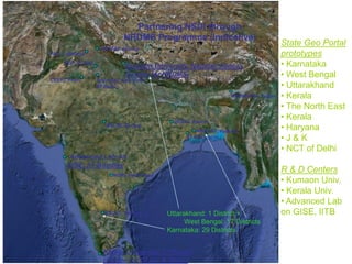
Partnering NSDI through
NRDMS Programme (Indicative)
NGRI, Hyderabad
IIT Kharagpur
Kerala University, T’ Puram
(Centre for GI Sc. & Tech.)
KSCST, Bengaluru
WBSCST, Kolkata
Kumaon University, Nainital/ Almora
(Centre for NRDMS)
Advanced Lab on
GISE, IIT Bombay
SoI/ NSDI, New Delhi
IIT Delhi
CEERI, Pilani
NERIWALM, Tezpur
PAU, Ludhiana
State Geo Portal
prototypes
• Karnataka
• West Bengal
• Uttarakhand
• Kerala
• The North East
• Kerala
• Haryana
• J & K
• NCT of Delhi
R & D Centers
• Kumaon Univ.
• Kerala Univ.
• Advanced Lab
on GISE, IITB
HPRSAC Shimla
WALMI, Bhopal
JRSAC Ranchi
Uttarakhand: 1 District +
West Bengal: 17 Districts
Karnataka: 29 Districts
NGF, D’ Dun
• Creation/ provision of GIS Assets/ WFS for applications
• Publication of foundation data layers - DEM, Ortho-image,
Positioning Network, Transport Network, Place names
• Development/ Implementation of NDR
• Integration of geo-referenced and statistical data
• Application Domain Working Groups (Railways, CAMPA,
Oil & Natural Gas, Disaster Management)
• Experimental NSDI Application Services from NIC Cloud
(Megharaj)
NSDI’s Present Focus
Registry Service/
Catalogue Service
on Web (CS-W)
Data
Assets
Metadata Data
Assets
Metadata Data
Assets
Metadata
Data
Asset
Metadata
Platform
Applications, Services
User
User
Applications/
Products/ DSS
National Data and
Data Services
Registry Catalogues
National
Data Portal
(data.gov.in)
Web Map Service (WMS)
for Decision Support
(WMS/ WFS/ WPS etc.)
(WMS/WFS/CS-W)
(publish/
harvest)
(find)
(bind)
National Agency (SoI, NRSC,
NBSSLUP, GSI, IMD, CoI
etc.)
State Government Agency
(e.g. Land Record, SGWB,
Mining & Geology, PHED
etc.)
Academia/ Industry/ Citizenry/
volunteered sources
On-line Data/ Services/ Apps
India Geo Portal (Up-scaled)
NSDI Technical Architecture with NDR
Thank you!!!!
www.nrdms.gov.in
www.nsdiindia.gov.in
psa@nic.in
psanrdms@gmail.com

More Related Content

PPTX
Application of GIS in Transportation Planning
PPTX
cartography PPT...pptx
PPTX
Gis Application
PDF
La géomatique, un outil de gestion pour le transport en commun
PPTX
3. lecture 2 cadastral surveying
PPTX
Remote Sensing error sources
PPTX
Inverse distance weighting
PDF
Capacity & Level of Service: Highways & Signalized Intersections (Indo-HCM)
Application of GIS in Transportation Planning
cartography PPT...pptx
Gis Application
La géomatique, un outil de gestion pour le transport en commun
3. lecture 2 cadastral surveying
Remote Sensing error sources
Inverse distance weighting
Capacity & Level of Service: Highways & Signalized Intersections (Indo-HCM)

What's hot (20)

PPT
Advance Public Transportation System
PPTX
Gis in urban
PPT
TIN IN GIS
PPTX
GIS & Raster
PDF
Introduction to GNSS (1)
PPTX
Traffic Volume Study
PPTX
4. lecture 3 data capturing techniques - total station and gps
PPTX
PPTX
GPS system and its application in mining
PPT
Applications of GIS to Logistics and Transportation
PPTX
Application of gis in urban planning
PPTX
History of GIS.pptx
PPTX
Chapter 1 regional geography
PPT
Avanced Image Classification
PPTX
High resolution data
DOCX
introduction to GIS
PPT
5 spatial data editing
PPT
History of GIS
PDF
Fundamentals of GIS
PPTX
Introduction to GPS presentation
Advance Public Transportation System
Gis in urban
TIN IN GIS
GIS & Raster
Introduction to GNSS (1)
Traffic Volume Study
4. lecture 3 data capturing techniques - total station and gps
GPS system and its application in mining
Applications of GIS to Logistics and Transportation
Application of gis in urban planning
History of GIS.pptx
Chapter 1 regional geography
Avanced Image Classification
High resolution data
introduction to GIS
5 spatial data editing
History of GIS
Fundamentals of GIS
Introduction to GPS presentation
Ad

Viewers also liked (20)

PDF
Situation of the GIS and SDI market in Greece
PPT
Presentation implementacion Project IGIS Serbia
PPTX
Towards 'Resilient Cities' - Harmonisation of Spatial Planning Information as...
PPT
Spatial Data Infrastructure in Europe
PPTX
10 Minutes with NSDI Web Services - Using GOS Dashboard and Widget
PDF
SDI in Croatia; shifting from NSDI 1.0 to NSDI 2.0
PDF
National Spatial Data Infrastructure (NSDI)
PDF
Spatial data infrastructure in Kyrgyzstan
PPT
Delaware GIS Strategic Planning Workshop (10/20/09)
PPTX
Are German Bonds Safe?
PPT
(Final) aat taiwan system
PPT
Analyzing Survey Data Concerning the Construction of Central Taiwan Science P...
PPT
The Future of Decision Making with a National Spatial Database Infrastructure...
PPTX
Taiwan stock exchange
PPTX
Monitary and fiscal policy
PPT
PPT
Chapter 14_The International Financial System
PPT
Taiwan
Situation of the GIS and SDI market in Greece
Presentation implementacion Project IGIS Serbia
Towards 'Resilient Cities' - Harmonisation of Spatial Planning Information as...
Spatial Data Infrastructure in Europe
10 Minutes with NSDI Web Services - Using GOS Dashboard and Widget
SDI in Croatia; shifting from NSDI 1.0 to NSDI 2.0
National Spatial Data Infrastructure (NSDI)
Spatial data infrastructure in Kyrgyzstan
Delaware GIS Strategic Planning Workshop (10/20/09)
Are German Bonds Safe?
(Final) aat taiwan system
Analyzing Survey Data Concerning the Construction of Central Taiwan Science P...
The Future of Decision Making with a National Spatial Database Infrastructure...
Taiwan stock exchange
Monitary and fiscal policy
Chapter 14_The International Financial System
Taiwan
Ad

Similar to NSDI policies and data initiatives - Dr. P.S. Acharya (20)

PPTX
Introduction to Spatial Data Infrastructure
PPT
NSDI_ Concepts and Components
PPTX
SDI In The Context Of Nepal
PPT
SDI.ppt
PPT
Karnataka Geospatial Experience FME World Tour 2017 India
PPTX
David Cowen UW-Madison Geospatial Summit 2015
PDF
Multi Layer GIS Platform in Digital India - Mr. Vishnu Chandra
PPT
spatial data infrastructure : data modelling and web services for data access
PPT
David Coleman presentation at SDI Summit 2014, Calgary, Canada, 17-19 Sept 2014
PDF
A step towards e governance - Mr. Vivek Chitale
PDF
B340614
PDF
03.18_08.35_GSDILiaisonReportLinkedIn
PPTX
Presentation on national mapping organization and spatial data infrastructure
PPTX
SDI-Initiatives-in-Nepal (1).pptx
PPTX
2018 Data4Dev Festival
PPT
The Concepts of Spatial Data Infrastructure and components.ppt
PPT
Using OGC Standards To Link BI and Spatial
PPTX
History of GIS.pptx
Introduction to Spatial Data Infrastructure
NSDI_ Concepts and Components
SDI In The Context Of Nepal
SDI.ppt
Karnataka Geospatial Experience FME World Tour 2017 India
David Cowen UW-Madison Geospatial Summit 2015
Multi Layer GIS Platform in Digital India - Mr. Vishnu Chandra
spatial data infrastructure : data modelling and web services for data access
David Coleman presentation at SDI Summit 2014, Calgary, Canada, 17-19 Sept 2014
A step towards e governance - Mr. Vivek Chitale
B340614
03.18_08.35_GSDILiaisonReportLinkedIn
Presentation on national mapping organization and spatial data infrastructure
SDI-Initiatives-in-Nepal (1).pptx
2018 Data4Dev Festival
The Concepts of Spatial Data Infrastructure and components.ppt
Using OGC Standards To Link BI and Spatial
History of GIS.pptx

Recently uploaded (20)

PDF
Peak of Data & AI Encore- AI for Metadata and Smarter Workflows
PDF
Reach Out and Touch Someone: Haptics and Empathic Computing
PPT
“AI and Expert System Decision Support & Business Intelligence Systems”
PPTX
A Presentation on Artificial Intelligence
PDF
Review of recent advances in non-invasive hemoglobin estimation
PDF
CIFDAQ's Market Insight: SEC Turns Pro Crypto
PDF
Architecting across the Boundaries of two Complex Domains - Healthcare & Tech...
PDF
KodekX | Application Modernization Development
PDF
Spectral efficient network and resource selection model in 5G networks
PDF
Encapsulation theory and applications.pdf
PDF
Agricultural_Statistics_at_a_Glance_2022_0.pdf
PDF
Approach and Philosophy of On baking technology
PDF
Machine learning based COVID-19 study performance prediction
PPTX
PA Analog/Digital System: The Backbone of Modern Surveillance and Communication
PDF
NewMind AI Monthly Chronicles - July 2025
PPTX
Understanding_Digital_Forensics_Presentation.pptx
PPTX
Effective Security Operations Center (SOC) A Modern, Strategic, and Threat-In...
PDF
TokAI - TikTok AI Agent : The First AI Application That Analyzes 10,000+ Vira...
PDF
Bridging biosciences and deep learning for revolutionary discoveries: a compr...
PDF
The Rise and Fall of 3GPP – Time for a Sabbatical?
Peak of Data & AI Encore- AI for Metadata and Smarter Workflows
Reach Out and Touch Someone: Haptics and Empathic Computing
“AI and Expert System Decision Support & Business Intelligence Systems”
A Presentation on Artificial Intelligence
Review of recent advances in non-invasive hemoglobin estimation
CIFDAQ's Market Insight: SEC Turns Pro Crypto
Architecting across the Boundaries of two Complex Domains - Healthcare & Tech...
KodekX | Application Modernization Development
Spectral efficient network and resource selection model in 5G networks
Encapsulation theory and applications.pdf
Agricultural_Statistics_at_a_Glance_2022_0.pdf
Approach and Philosophy of On baking technology
Machine learning based COVID-19 study performance prediction
PA Analog/Digital System: The Backbone of Modern Surveillance and Communication
NewMind AI Monthly Chronicles - July 2025
Understanding_Digital_Forensics_Presentation.pptx
Effective Security Operations Center (SOC) A Modern, Strategic, and Threat-In...
TokAI - TikTok AI Agent : The First AI Application That Analyzes 10,000+ Vira...
Bridging biosciences and deep learning for revolutionary discoveries: a compr...
The Rise and Fall of 3GPP – Time for a Sabbatical?

NSDI policies and data initiatives - Dr. P.S. Acharya

  • 1. NSDI Initiative – Policies and Data Standards PS Acharya, CEO, NSDI NRDMS-NSDI Division, DST, New Delhi NeGD, DeitY organized Thematic Workshop on "Use of GIS in Informed Planning And Decision Making“ Indian Habitat Centre, Lodi Road, New Delhi 29 March 2016
  • 2. NSDI Vision and objectives  National infrastructure for the availability of and access to organized spatial data  Use of the infrastructure at Community, Local, State, Regional and National levels for sustainable development Vision Objectives  Develop and maintain standard digital collection of data  Develop common solutions for Discovery, Access and Use of spatial data in response to the needs of diverse user groups  Increase the awareness & understanding of the vision, concepts and benefits of the NSDI
  • 3. Current Problems • Sheetwise storage of metadata as against feature data • No service metadata accessible (e.g. WMS/ WFS etc.) • Catalogue service unavailable • Querying on visualisation/ web map service absent • Content standard for ‘soil’ is available or getting developed on other themes but not in a machine- readable standard form (GML Application schema) • Metadata not accessible in machine readable form (XML) • Nodes for GIS Data Assets from providing agencies not operational (metadata search display) (Display of result of navigation query Using IndoorGML)
  • 4. • National Geospatial Policy, National Survey Act, State SDI Policies, Empowered SOI Committee, Technical Committee on NATMO • Co-branded BIS standards, Geology/ Forest/ Soil Data Specifications • National Foundation Spatial Data WFS and 1:50K countrywide WMS through National Data Portal (data.gov.in) • Admin. Boundary data harmonization Committee – SOI, Census, NRSC, NIC, MoSPI, HARSAC • Smart City Data by NATMO as WMS/ WFS, Mahakashi Data (1:5K, 1:10K), CityGML/ IndoorGML • UniqueIDs for parcels and flat properties for DoLR • Data Registry Prototype • NSDI Road Map – NGIS Deliverables Recent Progress Outline as of March 2016
  • 5. Policies/ Important Decisions • National Map Policy, 2005 • NSDI Resolution, 2006 • State Chief Secretaries Conference, Feb 2011 • National Remote Sensing Policy, 2011 • National Mirror Committee for ISO TC 211 by BIS • National Data Sharing & Accessibility Policy, 2012 • State Data Sharing Policies (Delhi, MP, Odisha) • National Geo-spatial Information Policy (being drafted)
  • 6. NDSAP - Highlights • ‘Proactive’ instead of ‘reactive’ sharing • Mandatory sharing of all data generated through public funds except on national security considerations • Publication of ‘Exclusion or Negative List’ • Four Types of Accesses (open, automatic registered, authorised registered, restricted e.g. G2G)
  • 8. End User/ Decision-maker (Stakeholders) Data Providers (Shareholders) User/ Web applications Bind Publish Find Catalogues, National Data Registry (NDR) Databases (Oracle Spatial, Shape files, DGN files, raster files etc.) Service-oriented Architecture
  • 9. Difficulties in sharing data between databases • Different rules for object’s categorization and definition (semantic heterogeneity) • Different data models and data structures (schematic heterogeneity) • Data collection, processing, presentation in different standards/ methods, different GIS platforms (syntactic heterogeneity) • Different institutional constraints (data access, rights of use, costs etc.)
  • 10. Approved ISO/ OGC Specifications deployed (Indicative) • Data Metadata (ISO 19115) (NSDI Metadata version 2.0) • Geography Markup Language (GML) (ISO 19136) • Web Feature Service (WFS) (ISO 19142) • Web Map Service (WMS) (ISO 19128) • Conceptual Schema Language (ISO 19103) • Rules for application schema (ISO 19109) • Catalogue Service on Web (CSW) • Style Layer Descriptor (SLD)
  • 12. Different Tiers of Standards for GI Management (Source: UNGGIM Draft prepared by ISO, OGC, and IHO)
  • 14. DGN file Pre-processing CSV file RDBMS Data Service Platform OGC-compliant WFS/ GML file Data updation (WFS/ GML planned) Re-engineering Process
  • 16. UML Class Diagram from Data Content on Surface Geology Source: GSI
  • 17. UML Class Diagram from Data Content on Forest Source: FSI
  • 18. • Kerala Geoportal (www.keralaspatialdatabase.org) • Karnataka Geoportal (www.karanatakageoportal.in) • North East SDI Geoportal (agnee.tezu.ernet.in:8004/nesdi) • Other State SDI projects under implementation (West Bengal, Haryana, Uttarakhand, J & K, Odisha) State SDI Initiative
  • 19. Viewing of uploaded image by registered user KSCST,KSSDI,NRDMS, IISc, Bangalore-12
  • 23. Partnering NSDI through NRDMS Programme (Indicative) NGRI, Hyderabad IIT Kharagpur Kerala University, T’ Puram (Centre for GI Sc. & Tech.) KSCST, Bengaluru WBSCST, Kolkata Kumaon University, Nainital/ Almora (Centre for NRDMS) Advanced Lab on GISE, IIT Bombay SoI/ NSDI, New Delhi IIT Delhi CEERI, Pilani NERIWALM, Tezpur PAU, Ludhiana State Geo Portal prototypes • Karnataka • West Bengal • Uttarakhand • Kerala • The North East • Kerala • Haryana • J & K • NCT of Delhi R & D Centers • Kumaon Univ. • Kerala Univ. • Advanced Lab on GISE, IITB HPRSAC Shimla WALMI, Bhopal JRSAC Ranchi Uttarakhand: 1 District + West Bengal: 17 Districts Karnataka: 29 Districts NGF, D’ Dun
  • 24. • Creation/ provision of GIS Assets/ WFS for applications • Publication of foundation data layers - DEM, Ortho-image, Positioning Network, Transport Network, Place names • Development/ Implementation of NDR • Integration of geo-referenced and statistical data • Application Domain Working Groups (Railways, CAMPA, Oil & Natural Gas, Disaster Management) • Experimental NSDI Application Services from NIC Cloud (Megharaj) NSDI’s Present Focus
  • 25. Registry Service/ Catalogue Service on Web (CS-W) Data Assets Metadata Data Assets Metadata Data Assets Metadata Data Asset Metadata Platform Applications, Services User User Applications/ Products/ DSS National Data and Data Services Registry Catalogues National Data Portal (data.gov.in) Web Map Service (WMS) for Decision Support (WMS/ WFS/ WPS etc.) (WMS/WFS/CS-W) (publish/ harvest) (find) (bind) National Agency (SoI, NRSC, NBSSLUP, GSI, IMD, CoI etc.) State Government Agency (e.g. Land Record, SGWB, Mining & Geology, PHED etc.) Academia/ Industry/ Citizenry/ volunteered sources On-line Data/ Services/ Apps India Geo Portal (Up-scaled) NSDI Technical Architecture with NDR