SlideShare a Scribd company logo
Precipitation Data
Categories
 Ground Station - Precipitation Datasets
 United States Geological Survey
 National Oceanic & Atmospheric Administration (National Climatic Data Center)
 Georgia Automated Environmental Monitoring Network (GAEMN)
 Georgia Forestry Commission
 Community Collaborative Rain, Hail & Snow Network
 GHCN (Global Historical Climatology Network)
 Gridded - Precipitation Datasets
 PRISM (Parameter-Elevation Relationships on Independent Slopes Model)
 GPCC (Global Precipitation Climatology Centre)
 CRU (Climate Research Unit Time Series)
 PRECipitation REConstruction over Land (PREC/L)
 CPC (Climate Prediction Center) Unified Gauge-Based Analysis of Global Daily
Precipitation
 MSU (Microwave Sounding Unit)
 University of Delaware
Categories
 Satellite - Precipitation Datasets
 TRMM (Tropical Rainfall Measuring Mission)
 Global Precipitation Measurement Mission (GPMM)
 PERSIANN (Precipitation Estimation from Remotely Sensed
Information using Artificial Neural Networks)
 CMORPH (CPC Morphing Technique)
 CMAP (CPC Merged Analysis of Precipitation)
 GPCP (Global Precipitation Climatology Project)
 Radar - Precipitation Datasets
 NEXRAD (Next Generation Weather Radar)
Measurement Frequency Classification
NRT 15 Minute Hourly Daily Monthly Yearly
Ground Stations - USGS, NOAA,
USGS, NOAA,
GFC,
USGS, NOAA,
GAEMN
USGS, NOAA,
GHCN
USGS, NOAA,
Gridded - - -
PRISM, CPC,
MSU
PRISM, GPCC,
CRU, PREC/L,
CPC, MSU, UoD
PRISM
Satellite
GPMM, TRMM,
PERSIANN,
CMORPH
- - - CMAP, GPCP -
Radar NEXRAD - - - - -
Ground Stations
United States Geological Survey
 http://waterdata.usgs.gov/ga/nwis/current/?type=precip&grou
p_key=county_cd
 Grid Size – Point Data (287 Stations)
 Domain – Georgia, USA
 Available Parameters – Gage Height, Precipitation,
Temperature, Dissolved Oxygen, pH, Turbidity, Specific
Conductance
 Methodology – Rain gages such as the non-recording
cylindrical container type or the recording weighing type, float
type and tipping-bucket type
 Time Period – 2007 - 2015
 Measurement Frequency – 15 Minute, Hourly, Daily,
Monthly, Annual
Ground Stations
National Oceanic & Atmospheric Administration
(National Climatic Data Center)
 http://www.ncdc.noaa.gov/cdo-web/datasets
 Grid Size – Point Data (68 Stations) (2% Coverage¹)
 Domain – Georgia, USA
 Available Parameters – Precipitation
 Methodology – An inlet-heated, wind-shielded weighing rain
gauge (configured with three load cell sensors), precipitation
(wetness) detector, and an auxiliary tipping bucket gauge.
 Time Period – 1971 - 2014
 Measurement Frequency – 15 Minute, Hourly, Daily,
Monthly, Annual (Dataset maybe delayed 6 months or more)
¹Coverage is an approximation of total completeness based on the
most complete data element, and the overall data range.
Ground Stations
Georgia Automated Environmental Monitoring Network
(GAEMN)
 http://weather.uga.edu/aemn/cgi-bin/AEMN.pl?site=GAAA
 Grid Size – Point Data (52 Stations)
 Domain – Georgia, USA
 Available Parameters – Air Temperature, Relative Humidity,
Rainfall, Solar Radiation, Wind Speed, Wind Direction, Soil
Temperature
 Methodology – Automated Weather Station
 Time Period – 2000 - 2015
 Measurement Frequency – Daily
Ground Stations
Georgia Forestry Commission (GFC)
 http://weather.gfc.state.ga.us/climate/climate.aspx
 Grid Size – Point Data (18 Stations)
 Domain – Georgia, USA
 Available Parameters – Air temperature, Relative Humidity,
Wind Direction, Wind Speed, Soil Temperatures
 Methodology – Automated Weather Station
 Time Period – 1998 - 2015
 Measurement Frequency – Hourly
Ground Stations
Community Collaborative Rain, Hail & Snow Network
 http://www.cocorahs.org/ViewData/ListMultiDayPrecipReports
.aspx
 Grid Size – Point Data (1163 Stations)
 Domain – Georgia, USA
 Available Parameters – Cumulative Precipitation
 Methodology – Standard 4-Inch Diameter Rain Gauge
 Time Period – 2000 - 2015
 Measurement Frequency – Irregular
Ground Stations
GHCN (Global Historical Climatology Network)
 http://gis.ncdc.noaa.gov/map/viewer/#app=cdo&cfg=cdo&theme=precip&la
yers=01&node=gis
 Grid Size – Point Data
 Domain - Global
 Available Parameters – Precipitation
 Methodology – The database was created from 15 source data sets,
including:
 The National Climatic Data Center's (NCDC's) World Weather Records
 CAC's Climate Anomaly Monitoring System (CAMS)
 NCAR's World Monthly Surface Station Climatology
 CIRES' (Eischeid/Diaz) Global precipitation data set
 P. Jones' Temperature data base for the world
 S. Nicholson's African precipitation data base
 Time Period – Variable (1697 - 1990)
 Measurement Frequency – Monthly
Gridded Datasets
PRISM (Parameter-Elevation Relationships on Independent
Slopes Model) - Christopher Daly and Kirk Bryant
 http://www.prism.oregonstate.edu/explorer/
 Grid Size – Climatologies (normals) are available at 30-arcsec (800
meters) and monthly data are available at 2.5 arcmin (4 km)
resolution.
 Domain – Contiguous US
 Main Variables – Dew Point Temperature, Max. & Min. Air
Temperature, Precipitation
 Methodology – The PRISM products use a weighted regression
scheme to account for complex climate regimes associated with
orography, rain shadows, temperature inversions, slope aspect,
coastal proximity, and other factors.
 Time Period – 1895 - Present
 Measurement Frequency – Daily, Monthly, Annual, 30-year
normals (1981-2010) (monthly and annual)
Gridded Datasets
GPCC (Global Precipitation Climatology Centre)
 http://www.esrl.noaa.gov/psd/data/gridded/data.gpcc.html
 Grid Size –
 0.5 degree latitude x 0.5 degree longitude global grid
 1.0 degree latitude x 1.0 degree longitude global grid
 2.5 degree latitude x 2.5 degree longitude global grid
 Domain - Global
 Available Parameters – Precipitation
 Methodology – Based on quality-controlled data from 67,200
stations world-wide that feature record durations of 10 years or
longer.
 Time Period – 1901 - 2010
 Measurement Frequency – Monthly
Gridded Datasets
CRU (Climate Research Unit Time Series)
 http://catalogue.ceda.ac.uk/uuid/4a6d071383976a5fb24b5b42e28cf
28f
 Grid Size – 0.5 degree latitude x 0.5 degree longitude global grid
(4,000 Stations)
 Domain - Global
 Available Parameters – Cloud cover, diurnal temperature range,
frost day frequency, precipitation, daily mean temperature, monthly
average daily maximum temperature, vapor pressure, Potential
Evapo-transpiration and wet day frequency.
 Methodology – Based on an archive of monthly mean
temperatures provided by more than 4000 weather stations
distributed around the world.
 Time Period – 1901 - 2013
 Measurement Spacing – Monthly
Gridded Datasets
PRECipitation REConstruction over Land (PREC/L)
 http://www.esrl.noaa.gov/psd/data/gridded/data.precl.html
 Grid Size – (17,000 Stations)
 0.5 degree latitude x 0.5 degree longitude global grid
 1.0 degree latitude x 1.0 degree longitude global grid
 2.5 degree latitude x 2.5 degree longitude global grid
 Domain - Global
 Available Parameters – Precipitation
 Methodology – Precipitation gauge measurements over land from
the GHCN-v2 (Global Historical Climatology Network version 2) are
interpolated
 Time Period – 1948 – Present (Except 0.5 degree data, which runs
behind)
 Measurement Frequency – Monthly
Gridded Datasets
CPC (Climate Prediction Center) Unified Gauge-Based
Analysis of Global Daily Precipitation
 http://www.esrl.noaa.gov/psd/data/gridded/data.unified.daily.c
onus.html
 Grid Size – 0.25 degree latitude x 0.25 degree longitude global
grid (30,000 Stations)
 Domain - Global
 Available Parameters – Precipitation
 Methodology – This dataset has two components: (a) the
"retrospective version" which uses 30K stations and spans 1979-
2005 and (b) the "real-time version" which uses 17K stations and
spans 2006-present.
 Time Period – 1948 – 2006 (Daily), 1948 – Present (Monthly)
 Measurement Frequency – Daily, Monthly
Gridded Datasets
MSU (Microwave Sounding Unit)
 http://www.esrl.noaa.gov/psd/data/gridded/data.msu.html
 Resolution – 2.5 degree latitude x 2.5 degree longitude global
grid
 Domain - Global
 Available Parameters – Precipitation, Temperature
 Methodology – The NOAA satellites contributing to this
dataset are, in order of their launch, TIROS-N, NOAA-6, -7, -9, -
10,-11, and NOAA-12.
 Time Period – 1979 – 1996
 Measurement Frequency – Daily, Monthly
Gridded Datasets
University of Delaware (UoD)
 http://www.esrl.noaa.gov/psd/data/gridded/data.UDel_AirT_P
recip.html
 Resolution – 0.5 degree latitude x 0.5 degree longitude global
grid
 Domain - Global
 Available Parameters – Precipitation, Temperature
 Methodology - Cort Willmott & Kenji Matsuura of the
University of Delaware have put data together from a large
number of stations, both from the GHCN2 (Global Historical
Climate Network) and, more extensively, from the archive of
Legates & Willmott.
 Time Period – 1901 – 2010
 Measurement Frequency – Monthly
Satellite Datasets
TRMM (Tropical Rainfall Measuring Mission)
 http://trmm.gsfc.nasa.gov/
 Resolution - 0.25 degree latitude x 0.25 degree longitude global
grid
 Domain - Global
 Available Parameters – Precipitation
 Methodology – The mission uses 5 instruments: Precipitation
Radar (PR), TRMM Microwave Imager (TMI), Visible Infrared
Scanner (VIRS), Clouds & Earths Radiant Energy System
(CERES) and Lightning Imaging Sensor (LSI).
 Time Period – 1997 – (March) 2015
 Measurement Frequency – 3 Hour (Near Real Time)
Satellite Datasets
Global Precipitation Measurement Mission (GPMM)
 http://pmm.nasa.gov/data-access/downloads/gpm
 Resolution - 0.1 degree latitude x 0.1 degree longitude global
grid
 Domain - Global
 Available Parameters – Precipitation
 Methodology – The satellite carries a microwave imager. Its
scanning antenna rotates 32 times per minute, while a downward
pointing detector reads microwaves reflected from the
atmosphere below. As it orbits, GPM scans the Earth’s
atmosphere with its Dual-Frequency Precipitation Radar. The
radar scans in two frequencies, the Ku scan (13.6 gigahertz) and
the Ka scan (35.5 gigahertz).
 Time Period – (March) 2014 - Present
 Measurement Frequency – 3 Hour (Near Real Time)
Satellite Datasets
PERSIANN (Precipitation Estimation from Remotely
Sensed Information using Artificial Neural Networks)
 http://chrs.web.uci.edu/persiann/
 Resolution – 0.25 degree latitude x 0.25 degree longitude
global grid
 Domain - Global
 Available Parameters – Precipitation, Atmosphere
 Methodology – The PERSIANN algorithm used here is based
on the geostationary longwave infrared imagery to generate
global rainfall.
 Time Period – 1979 - Present
 Measurement Frequency – 3 Hour (Near Real Time)
Satellite Datasets
CMORPH (CPC Morphing Technique)
 http://www.cpc.ncep.noaa.gov/products/janowiak/cmorph_des
cription.html
 Resolution – 0.25 degree latitude x 0.25 degree longitude
global grid
 Domain - Global
 Available Parameters – Precipitation, Atmosphere
 Methodology – The precipitation estimates derived from the
passive microwaves aboard the DMSP 13, 14 & 15 (SSM/I), the
NOAA-15, 16, 17 & 18 (AMSU-B), and AMSR-E and TMI aboard
NASA's Aqua and TRMM spacecraft, respectively.
 Time Period – 2002 - 2013
 Measurement Frequency – 3 Hour, Daily (Near Real Time)
Satellite Datasets
CMAP (CPC Merged Analysis of Precipitation)
 http://www.esrl.noaa.gov/psd/data/gridded/data.cmap.html
 Resolution – 2.5 degree latitude x 2.5 degree longitude global
grid
 Domain - Global
 Available Parameters – Precipitation, Atmosphere
 Methodology – Inputs are derived from gauge analysis;
microwave and infrared observations from polar orbiting and
geostationary satellites
 Time Period – 1979 - 2011
 Measurement Frequency – Monthly Mean
Satellite Datasets
GPCP (Global Precipitation Climatology Project)
 http://www.esrl.noaa.gov/psd/data/gridded/data.gpcp.html
 Resolution – 2.5 degree latitude x 2.5 degree longitude global grid
 Domain - Global
 Available Parameters – Precipitation, Atmosphere
 Methodology –
 The Version 2 Data Set contains data from several contributing centers:
 GPCP Polar Satellite Precipitation Data Centre - Emission (SSM/I emission estimates)
 F17 SSMIS: calibrating microwave data source to replace the F13 SSM/I, which failed in
September 2009
 GPCP Polar Satellite Precipitation Data Centre - Scattering (SSM/I scattering estimates)
 GPCP Geostationary Satellite Precipitation Data Centre (GPI and OPI estimates and rain
gauge analyses)
 NASA/GSFC Satellite Applications Office (TOVS estimates)
 GPCP Global Precipitation Climatology Centre (rain gauge analyses)
 Time Period – 1979 – (February) 2015
 Measurement Frequency – Monthly Mean
Radar
NEXRAD (Next Generation Weather Radar)
 http://www.ncdc.noaa.gov/nexradinv/
 Domain - US
 Available Parameters – Precipitation
 Methodology – NEXRAD (Next Generation Radar) currently
comprises 159 sites throughout the United States and select
overseas locations.
 Time Period – 1991 - 2015
 Measurement Frequency – Near Real Time
TDWR – Terminal Doppler Weather Radar
Data Sources
 PSD Gridded Climate Datasets: All
http://www.esrl.noaa.gov/psd/data/gridded/
 NCAR UCAR Climate Data Guide
https://climatedataguide.ucar.edu/

More Related Content

PPTX
Data Models - GIS I
PPTX
Perencanaan dan Pengembangan Wilayah
PDF
OSN KEBUMIAN.pdf
PDF
Tata Cara Pemilihan Lokasi TPA Sampah
PPT
PPTX
Geopark Nasional Pongkor menuju UNESCO Global Geopark
PDF
I ruang lingkup gusti rusmayadi
Data Models - GIS I
Perencanaan dan Pengembangan Wilayah
OSN KEBUMIAN.pdf
Tata Cara Pemilihan Lokasi TPA Sampah
Geopark Nasional Pongkor menuju UNESCO Global Geopark
I ruang lingkup gusti rusmayadi

What's hot (20)

PPT
Comdev+dalam+proper
PPTX
BAB 5_STD (1).pptx KELAS X SEMESTER 2 MATERI DINAMIKA LITOSFER
PDF
Rencana Pola Ruang dalam Rencana Tata Ruang Wilayah Nasional
PPT
Penginderaan jauh
PPTX
application of remote sensing in defence forces
DOCX
Batimetri
PPT
3.a awan dan-presipitasi
PDF
Kuliah 1 siklus hidrologi
PPSX
Toponimi Jalan bertema "Pulau"
PPT
Daya dukung lingkungan
PPT
Chris Spry Ikonos
PDF
Presentasi undip jokowi agropolitan [compatibility mode]
PDF
Pengembangan dan Perencanaan Sistem Jaringan Air Limbah Terpusat
PDF
Pola Pengelolaan Sumber Daya Air WS Brantas
PPTX
DOC
Rpp 5 geo atmosfer
PPTX
paras candika muliansyah (16102123)
PPTX
MODIS (Moderate Resolution Imaging Spectrometer)
PDF
Pedoman Penyusunan Studi Kelayakan Pengembangan Sistem Penyediaan Air Minum
PPTX
Penentuan Arah dan Sudut
Comdev+dalam+proper
BAB 5_STD (1).pptx KELAS X SEMESTER 2 MATERI DINAMIKA LITOSFER
Rencana Pola Ruang dalam Rencana Tata Ruang Wilayah Nasional
Penginderaan jauh
application of remote sensing in defence forces
Batimetri
3.a awan dan-presipitasi
Kuliah 1 siklus hidrologi
Toponimi Jalan bertema "Pulau"
Daya dukung lingkungan
Chris Spry Ikonos
Presentasi undip jokowi agropolitan [compatibility mode]
Pengembangan dan Perencanaan Sistem Jaringan Air Limbah Terpusat
Pola Pengelolaan Sumber Daya Air WS Brantas
Rpp 5 geo atmosfer
paras candika muliansyah (16102123)
MODIS (Moderate Resolution Imaging Spectrometer)
Pedoman Penyusunan Studi Kelayakan Pengembangan Sistem Penyediaan Air Minum
Penentuan Arah dan Sudut
Ad

Viewers also liked (20)

PPTX
Kinds of precipitation
PPTX
Precipitation ppt
PPT
Precipitation presentation
PPTX
Surface Water Hidrology - Chapter 2
PPTX
rainfall_presentation
PPTX
Presentation adv gis 08 01-2014
PDF
Reducing uncertainty in carbon cycle science of North America: a synthesis pr...
PPT
Learning from data for wind–wave forecasting
PDF
Revised intensity frequency-duration (ifd) design rainfalls estimates for wa ...
PPT
Artificial neural networks in hydrology
PPT
One–day wave forecasts based on artificial neural networks
PPTX
Water in the Western United States - California: A Case Study
PPTX
Practical Applications of Hydrology
PDF
Download-manuals-hydrometeorology-data processing-12howtoanalyserainfalldata
PPT
Extreme value distribution to predict maximum precipitation
PPT
Neural networks for the prediction and forecasting of water resources variables
PPT
Population Data Workbench - Meteorology Data Query
PPT
03 lect1meteorology
PPT
Wlk Presentation Final3
PDF
Nir y. krakauer
Kinds of precipitation
Precipitation ppt
Precipitation presentation
Surface Water Hidrology - Chapter 2
rainfall_presentation
Presentation adv gis 08 01-2014
Reducing uncertainty in carbon cycle science of North America: a synthesis pr...
Learning from data for wind–wave forecasting
Revised intensity frequency-duration (ifd) design rainfalls estimates for wa ...
Artificial neural networks in hydrology
One–day wave forecasts based on artificial neural networks
Water in the Western United States - California: A Case Study
Practical Applications of Hydrology
Download-manuals-hydrometeorology-data processing-12howtoanalyserainfalldata
Extreme value distribution to predict maximum precipitation
Neural networks for the prediction and forecasting of water resources variables
Population Data Workbench - Meteorology Data Query
03 lect1meteorology
Wlk Presentation Final3
Nir y. krakauer
Ad

Similar to Precipitation Data - Georgia, USA (20)

PDF
Trento june2015 slides
PDF
5 - K Prasad - Weather forecasting in modern age-Sep-16
PDF
Drought monitoring, Precipitation statistics, and water balance with freely a...
PDF
Program on Mathematical and Statistical Methods for Climate and the Earth Sys...
PPTX
Available data for crop modelling
PPTX
EcoTas13 Hutchinson e-MAST ANU
PDF
Precipitation
PPT
TU2.L10 - NEXT-GENERATION GLOBAL PRECIPITATION PRODUCTS AND THEIR APPLICATIONS
PPT
Hygrology Precipitation introduction civil part 01
PDF
A Comprehensive Investigation into the Accuracy of Soft Computing Tools for D...
PPTX
Michael Hutchinson_Topographic-dependent modelling of surface climate for ear...
PPTX
Julian R - Spatial downscaling of future climate predictions for agriculture ...
PPTX
Workshop climate variability and modeling in Laos
PPTX
Hydrology.pptx
PDF
Performance evaluation of ERA5 precipitation data for extreme events based on...
PDF
Downscaling and its limitation on climate change impact assessments
PDF
Sources of climate data ma
PDF
Scheel et al_2011_trmm_andes
PPTX
Climate data in india - Open and Closed
PPTX
Chapter 2 Physical Hydrology Evapotranspiration Factors2024.pptx
Trento june2015 slides
5 - K Prasad - Weather forecasting in modern age-Sep-16
Drought monitoring, Precipitation statistics, and water balance with freely a...
Program on Mathematical and Statistical Methods for Climate and the Earth Sys...
Available data for crop modelling
EcoTas13 Hutchinson e-MAST ANU
Precipitation
TU2.L10 - NEXT-GENERATION GLOBAL PRECIPITATION PRODUCTS AND THEIR APPLICATIONS
Hygrology Precipitation introduction civil part 01
A Comprehensive Investigation into the Accuracy of Soft Computing Tools for D...
Michael Hutchinson_Topographic-dependent modelling of surface climate for ear...
Julian R - Spatial downscaling of future climate predictions for agriculture ...
Workshop climate variability and modeling in Laos
Hydrology.pptx
Performance evaluation of ERA5 precipitation data for extreme events based on...
Downscaling and its limitation on climate change impact assessments
Sources of climate data ma
Scheel et al_2011_trmm_andes
Climate data in india - Open and Closed
Chapter 2 Physical Hydrology Evapotranspiration Factors2024.pptx

Recently uploaded (20)

PDF
Insitu conservation seminar , national park ,enthobotanical significance
PPTX
NOISE-MITIGATION.-pptxnaksnsbaksjvdksbsksk
DOCX
Epoxy Coated Steel Bolted Tanks for Beverage Wastewater Storage Manages Liqui...
DOCX
Epoxy Coated Steel Bolted Tanks for Fish Farm Water Provides Reliable Water f...
PPTX
Plant_Cell_Presentation.pptx.com learning purpose
DOCX
Epoxy Coated Steel Bolted Tanks for Agricultural Waste Biogas Digesters Turns...
PPTX
Topic Globalisation and Lifelines of National Economy (1).pptx
PPTX
Disposal Of Wastes.pptx according to community medicine
PPTX
Making GREEN and Sustainable Urban Spaces
PPTX
9.-Sedatives-and-Hypnotics.pptxcccccccccccccccccccppt
PDF
Earthquake, learn from the past and do it now.pdf
PDF
Session 1 Introduction to the IPCC - Programme Officer M Shongwe
PPTX
carbon footprint, emissioncontrol and carbon tax
PPTX
Concept of Safe and Wholesome Water.pptx
PDF
Lecture 2 investigation of renal diseses.pdf
PDF
The Role of Non-Legal Advocates in Fighting Social Injustice.pdf
DOCX
Epoxy Coated Steel Bolted Tanks for Leachate Storage Securely Contain Landfil...
PPTX
The age of Artificial Intelligence and our future
PPTX
Green and Cream Aesthetic Group Project Presentation.pptx
PPTX
UN Environmental Inventory User Training 2021.pptx
Insitu conservation seminar , national park ,enthobotanical significance
NOISE-MITIGATION.-pptxnaksnsbaksjvdksbsksk
Epoxy Coated Steel Bolted Tanks for Beverage Wastewater Storage Manages Liqui...
Epoxy Coated Steel Bolted Tanks for Fish Farm Water Provides Reliable Water f...
Plant_Cell_Presentation.pptx.com learning purpose
Epoxy Coated Steel Bolted Tanks for Agricultural Waste Biogas Digesters Turns...
Topic Globalisation and Lifelines of National Economy (1).pptx
Disposal Of Wastes.pptx according to community medicine
Making GREEN and Sustainable Urban Spaces
9.-Sedatives-and-Hypnotics.pptxcccccccccccccccccccppt
Earthquake, learn from the past and do it now.pdf
Session 1 Introduction to the IPCC - Programme Officer M Shongwe
carbon footprint, emissioncontrol and carbon tax
Concept of Safe and Wholesome Water.pptx
Lecture 2 investigation of renal diseses.pdf
The Role of Non-Legal Advocates in Fighting Social Injustice.pdf
Epoxy Coated Steel Bolted Tanks for Leachate Storage Securely Contain Landfil...
The age of Artificial Intelligence and our future
Green and Cream Aesthetic Group Project Presentation.pptx
UN Environmental Inventory User Training 2021.pptx

Precipitation Data - Georgia, USA

  • 2. Categories  Ground Station - Precipitation Datasets  United States Geological Survey  National Oceanic & Atmospheric Administration (National Climatic Data Center)  Georgia Automated Environmental Monitoring Network (GAEMN)  Georgia Forestry Commission  Community Collaborative Rain, Hail & Snow Network  GHCN (Global Historical Climatology Network)  Gridded - Precipitation Datasets  PRISM (Parameter-Elevation Relationships on Independent Slopes Model)  GPCC (Global Precipitation Climatology Centre)  CRU (Climate Research Unit Time Series)  PRECipitation REConstruction over Land (PREC/L)  CPC (Climate Prediction Center) Unified Gauge-Based Analysis of Global Daily Precipitation  MSU (Microwave Sounding Unit)  University of Delaware
  • 3. Categories  Satellite - Precipitation Datasets  TRMM (Tropical Rainfall Measuring Mission)  Global Precipitation Measurement Mission (GPMM)  PERSIANN (Precipitation Estimation from Remotely Sensed Information using Artificial Neural Networks)  CMORPH (CPC Morphing Technique)  CMAP (CPC Merged Analysis of Precipitation)  GPCP (Global Precipitation Climatology Project)  Radar - Precipitation Datasets  NEXRAD (Next Generation Weather Radar)
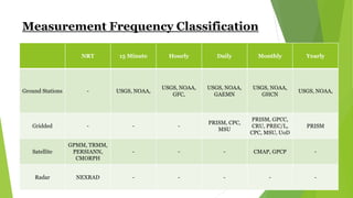
  • 4. Measurement Frequency Classification NRT 15 Minute Hourly Daily Monthly Yearly Ground Stations - USGS, NOAA, USGS, NOAA, GFC, USGS, NOAA, GAEMN USGS, NOAA, GHCN USGS, NOAA, Gridded - - - PRISM, CPC, MSU PRISM, GPCC, CRU, PREC/L, CPC, MSU, UoD PRISM Satellite GPMM, TRMM, PERSIANN, CMORPH - - - CMAP, GPCP - Radar NEXRAD - - - - -
  • 5. Ground Stations United States Geological Survey  http://waterdata.usgs.gov/ga/nwis/current/?type=precip&grou p_key=county_cd  Grid Size – Point Data (287 Stations)  Domain – Georgia, USA  Available Parameters – Gage Height, Precipitation, Temperature, Dissolved Oxygen, pH, Turbidity, Specific Conductance  Methodology – Rain gages such as the non-recording cylindrical container type or the recording weighing type, float type and tipping-bucket type  Time Period – 2007 - 2015  Measurement Frequency – 15 Minute, Hourly, Daily, Monthly, Annual
  • 6. Ground Stations National Oceanic & Atmospheric Administration (National Climatic Data Center)  http://www.ncdc.noaa.gov/cdo-web/datasets  Grid Size – Point Data (68 Stations) (2% Coverage¹)  Domain – Georgia, USA  Available Parameters – Precipitation  Methodology – An inlet-heated, wind-shielded weighing rain gauge (configured with three load cell sensors), precipitation (wetness) detector, and an auxiliary tipping bucket gauge.  Time Period – 1971 - 2014  Measurement Frequency – 15 Minute, Hourly, Daily, Monthly, Annual (Dataset maybe delayed 6 months or more) ¹Coverage is an approximation of total completeness based on the most complete data element, and the overall data range.
  • 7. Ground Stations Georgia Automated Environmental Monitoring Network (GAEMN)  http://weather.uga.edu/aemn/cgi-bin/AEMN.pl?site=GAAA  Grid Size – Point Data (52 Stations)  Domain – Georgia, USA  Available Parameters – Air Temperature, Relative Humidity, Rainfall, Solar Radiation, Wind Speed, Wind Direction, Soil Temperature  Methodology – Automated Weather Station  Time Period – 2000 - 2015  Measurement Frequency – Daily
  • 8. Ground Stations Georgia Forestry Commission (GFC)  http://weather.gfc.state.ga.us/climate/climate.aspx  Grid Size – Point Data (18 Stations)  Domain – Georgia, USA  Available Parameters – Air temperature, Relative Humidity, Wind Direction, Wind Speed, Soil Temperatures  Methodology – Automated Weather Station  Time Period – 1998 - 2015  Measurement Frequency – Hourly
  • 9. Ground Stations Community Collaborative Rain, Hail & Snow Network  http://www.cocorahs.org/ViewData/ListMultiDayPrecipReports .aspx  Grid Size – Point Data (1163 Stations)  Domain – Georgia, USA  Available Parameters – Cumulative Precipitation  Methodology – Standard 4-Inch Diameter Rain Gauge  Time Period – 2000 - 2015  Measurement Frequency – Irregular
  • 10. Ground Stations GHCN (Global Historical Climatology Network)  http://gis.ncdc.noaa.gov/map/viewer/#app=cdo&cfg=cdo&theme=precip&la yers=01&node=gis  Grid Size – Point Data  Domain - Global  Available Parameters – Precipitation  Methodology – The database was created from 15 source data sets, including:  The National Climatic Data Center's (NCDC's) World Weather Records  CAC's Climate Anomaly Monitoring System (CAMS)  NCAR's World Monthly Surface Station Climatology  CIRES' (Eischeid/Diaz) Global precipitation data set  P. Jones' Temperature data base for the world  S. Nicholson's African precipitation data base  Time Period – Variable (1697 - 1990)  Measurement Frequency – Monthly
  • 11. Gridded Datasets PRISM (Parameter-Elevation Relationships on Independent Slopes Model) - Christopher Daly and Kirk Bryant  http://www.prism.oregonstate.edu/explorer/  Grid Size – Climatologies (normals) are available at 30-arcsec (800 meters) and monthly data are available at 2.5 arcmin (4 km) resolution.  Domain – Contiguous US  Main Variables – Dew Point Temperature, Max. & Min. Air Temperature, Precipitation  Methodology – The PRISM products use a weighted regression scheme to account for complex climate regimes associated with orography, rain shadows, temperature inversions, slope aspect, coastal proximity, and other factors.  Time Period – 1895 - Present  Measurement Frequency – Daily, Monthly, Annual, 30-year normals (1981-2010) (monthly and annual)
  • 12. Gridded Datasets GPCC (Global Precipitation Climatology Centre)  http://www.esrl.noaa.gov/psd/data/gridded/data.gpcc.html  Grid Size –  0.5 degree latitude x 0.5 degree longitude global grid  1.0 degree latitude x 1.0 degree longitude global grid  2.5 degree latitude x 2.5 degree longitude global grid  Domain - Global  Available Parameters – Precipitation  Methodology – Based on quality-controlled data from 67,200 stations world-wide that feature record durations of 10 years or longer.  Time Period – 1901 - 2010  Measurement Frequency – Monthly
  • 13. Gridded Datasets CRU (Climate Research Unit Time Series)  http://catalogue.ceda.ac.uk/uuid/4a6d071383976a5fb24b5b42e28cf 28f  Grid Size – 0.5 degree latitude x 0.5 degree longitude global grid (4,000 Stations)  Domain - Global  Available Parameters – Cloud cover, diurnal temperature range, frost day frequency, precipitation, daily mean temperature, monthly average daily maximum temperature, vapor pressure, Potential Evapo-transpiration and wet day frequency.  Methodology – Based on an archive of monthly mean temperatures provided by more than 4000 weather stations distributed around the world.  Time Period – 1901 - 2013  Measurement Spacing – Monthly
  • 14. Gridded Datasets PRECipitation REConstruction over Land (PREC/L)  http://www.esrl.noaa.gov/psd/data/gridded/data.precl.html  Grid Size – (17,000 Stations)  0.5 degree latitude x 0.5 degree longitude global grid  1.0 degree latitude x 1.0 degree longitude global grid  2.5 degree latitude x 2.5 degree longitude global grid  Domain - Global  Available Parameters – Precipitation  Methodology – Precipitation gauge measurements over land from the GHCN-v2 (Global Historical Climatology Network version 2) are interpolated  Time Period – 1948 – Present (Except 0.5 degree data, which runs behind)  Measurement Frequency – Monthly
  • 15. Gridded Datasets CPC (Climate Prediction Center) Unified Gauge-Based Analysis of Global Daily Precipitation  http://www.esrl.noaa.gov/psd/data/gridded/data.unified.daily.c onus.html  Grid Size – 0.25 degree latitude x 0.25 degree longitude global grid (30,000 Stations)  Domain - Global  Available Parameters – Precipitation  Methodology – This dataset has two components: (a) the "retrospective version" which uses 30K stations and spans 1979- 2005 and (b) the "real-time version" which uses 17K stations and spans 2006-present.  Time Period – 1948 – 2006 (Daily), 1948 – Present (Monthly)  Measurement Frequency – Daily, Monthly
  • 16. Gridded Datasets MSU (Microwave Sounding Unit)  http://www.esrl.noaa.gov/psd/data/gridded/data.msu.html  Resolution – 2.5 degree latitude x 2.5 degree longitude global grid  Domain - Global  Available Parameters – Precipitation, Temperature  Methodology – The NOAA satellites contributing to this dataset are, in order of their launch, TIROS-N, NOAA-6, -7, -9, - 10,-11, and NOAA-12.  Time Period – 1979 – 1996  Measurement Frequency – Daily, Monthly
  • 17. Gridded Datasets University of Delaware (UoD)  http://www.esrl.noaa.gov/psd/data/gridded/data.UDel_AirT_P recip.html  Resolution – 0.5 degree latitude x 0.5 degree longitude global grid  Domain - Global  Available Parameters – Precipitation, Temperature  Methodology - Cort Willmott & Kenji Matsuura of the University of Delaware have put data together from a large number of stations, both from the GHCN2 (Global Historical Climate Network) and, more extensively, from the archive of Legates & Willmott.  Time Period – 1901 – 2010  Measurement Frequency – Monthly
  • 18. Satellite Datasets TRMM (Tropical Rainfall Measuring Mission)  http://trmm.gsfc.nasa.gov/  Resolution - 0.25 degree latitude x 0.25 degree longitude global grid  Domain - Global  Available Parameters – Precipitation  Methodology – The mission uses 5 instruments: Precipitation Radar (PR), TRMM Microwave Imager (TMI), Visible Infrared Scanner (VIRS), Clouds & Earths Radiant Energy System (CERES) and Lightning Imaging Sensor (LSI).  Time Period – 1997 – (March) 2015  Measurement Frequency – 3 Hour (Near Real Time)
  • 19. Satellite Datasets Global Precipitation Measurement Mission (GPMM)  http://pmm.nasa.gov/data-access/downloads/gpm  Resolution - 0.1 degree latitude x 0.1 degree longitude global grid  Domain - Global  Available Parameters – Precipitation  Methodology – The satellite carries a microwave imager. Its scanning antenna rotates 32 times per minute, while a downward pointing detector reads microwaves reflected from the atmosphere below. As it orbits, GPM scans the Earth’s atmosphere with its Dual-Frequency Precipitation Radar. The radar scans in two frequencies, the Ku scan (13.6 gigahertz) and the Ka scan (35.5 gigahertz).  Time Period – (March) 2014 - Present  Measurement Frequency – 3 Hour (Near Real Time)
  • 20. Satellite Datasets PERSIANN (Precipitation Estimation from Remotely Sensed Information using Artificial Neural Networks)  http://chrs.web.uci.edu/persiann/  Resolution – 0.25 degree latitude x 0.25 degree longitude global grid  Domain - Global  Available Parameters – Precipitation, Atmosphere  Methodology – The PERSIANN algorithm used here is based on the geostationary longwave infrared imagery to generate global rainfall.  Time Period – 1979 - Present  Measurement Frequency – 3 Hour (Near Real Time)
  • 21. Satellite Datasets CMORPH (CPC Morphing Technique)  http://www.cpc.ncep.noaa.gov/products/janowiak/cmorph_des cription.html  Resolution – 0.25 degree latitude x 0.25 degree longitude global grid  Domain - Global  Available Parameters – Precipitation, Atmosphere  Methodology – The precipitation estimates derived from the passive microwaves aboard the DMSP 13, 14 & 15 (SSM/I), the NOAA-15, 16, 17 & 18 (AMSU-B), and AMSR-E and TMI aboard NASA's Aqua and TRMM spacecraft, respectively.  Time Period – 2002 - 2013  Measurement Frequency – 3 Hour, Daily (Near Real Time)
  • 22. Satellite Datasets CMAP (CPC Merged Analysis of Precipitation)  http://www.esrl.noaa.gov/psd/data/gridded/data.cmap.html  Resolution – 2.5 degree latitude x 2.5 degree longitude global grid  Domain - Global  Available Parameters – Precipitation, Atmosphere  Methodology – Inputs are derived from gauge analysis; microwave and infrared observations from polar orbiting and geostationary satellites  Time Period – 1979 - 2011  Measurement Frequency – Monthly Mean
  • 23. Satellite Datasets GPCP (Global Precipitation Climatology Project)  http://www.esrl.noaa.gov/psd/data/gridded/data.gpcp.html  Resolution – 2.5 degree latitude x 2.5 degree longitude global grid  Domain - Global  Available Parameters – Precipitation, Atmosphere  Methodology –  The Version 2 Data Set contains data from several contributing centers:  GPCP Polar Satellite Precipitation Data Centre - Emission (SSM/I emission estimates)  F17 SSMIS: calibrating microwave data source to replace the F13 SSM/I, which failed in September 2009  GPCP Polar Satellite Precipitation Data Centre - Scattering (SSM/I scattering estimates)  GPCP Geostationary Satellite Precipitation Data Centre (GPI and OPI estimates and rain gauge analyses)  NASA/GSFC Satellite Applications Office (TOVS estimates)  GPCP Global Precipitation Climatology Centre (rain gauge analyses)  Time Period – 1979 – (February) 2015  Measurement Frequency – Monthly Mean
  • 24. Radar NEXRAD (Next Generation Weather Radar)  http://www.ncdc.noaa.gov/nexradinv/  Domain - US  Available Parameters – Precipitation  Methodology – NEXRAD (Next Generation Radar) currently comprises 159 sites throughout the United States and select overseas locations.  Time Period – 1991 - 2015  Measurement Frequency – Near Real Time TDWR – Terminal Doppler Weather Radar
  • 25. Data Sources  PSD Gridded Climate Datasets: All http://www.esrl.noaa.gov/psd/data/gridded/  NCAR UCAR Climate Data Guide https://climatedataguide.ucar.edu/