Implementation of OGC Web Coverage Service Using HDF5/HDF-EOS5 as the Base File Format
- 1. Implementation of OGC Web Coverage Service Using HDF5/HDF-EOS5 as the Base File Format Peichuan Li, Ph.D. Liping Di, Ph.D. Genong (Eugene) Yu, Ph.D. Center for Spatial Information Science and Systems (CSISS) George Mason University 6301 Ivy Ln, Suite #620 Greenbelt, MD 20770 Emails:(pli4,ldi,gyu)@gmu.edu CSISS 11/08/2007 Page LCenter for Spatial Information Science and Systems 1
- 2. Contents • • • • Introduction Methodology Samples of system implementation Discussion and Conclusion CSISS 10/08/2007 Center for Spatial Information Science and Systems Page 2
- 3. Introduction 1. Activities & Purpose – The requirement for the ongoing Sensor Web project conducted at CSISS ; – Research its possibility for WCS to serve new kinds of base data that it is different from what we have previously done; CSISS 10/08/2007 Center for Spatial Information Science and Systems Page 3
- 4. Introduction (Cont.) 2. Objectives – Final Goal: • To implement a Web Coverage Service (WCS) for describing and delivering multidimensional geospatial coverage data in HDF-EOS 5/HDF-5 format. The services followed OGC WCS Specification 1.1.0. [1] • – The Web Coverage Service (WCS) implemented provides the Transaction operation.[2] The transaction provides the flexibility of reserving derived results in standard geospatial services. Phrases: • • Phrase 1: – Focus on Aura/HIRDSL L2(hdfeos5) base data; – Implement general operations of WCS. i.e. getCoverage, getCapabilites, DescribeCoverage…; – Provide he5 Swath and netCDF responding to client’s request; Phrase 2: – Add Transaction operation; – Provide Aura / plain hdf5 base data support; CSISS 10/08/2007 Center for Spatial Information Science and Systems Page 4
- 5. Introduction (Cont.) 3. About Aura HIRDLS data [3] – – – – – HIRDLS is an infrared limb-scanning radiometer designed to sound the upper troposphere, stratosphere, and mesosphere to determine temperature; HIRDLS measures the concentrations of O3, H2O, CH4, N2O, NO2, HNO3, N2O5, CFC11, CFC12, ClONO2, and aerosols; Locations of polar stratospheric clouds and cloud tops. The goals were to provide sounding observations with horizontal and vertical resolution superior to that previously obtained; To observe the lower stratosphere with improved sensitivity and accuracy; and to improve the understanding of atmospheric processes through data analysis, diagnostics, and use of two- and three-dimensional models. CSISS 10/08/2007 Center for Spatial Information Science and Systems Page 5
- 6. Introduction (Cont.) • About AutoChem [4] – AutoChem is a NASA release software that constitutes an automatic computer code generator and a documenter for chemically reactive systems written by David Lary between 1993 and the present. It was designed primarily for modeling atmospheric chemistry, and in particular, for chemical data assimilation . CSISS 10/08/2007 Center for Spatial Information Science and Systems Page 6
- 7. Methodology 1. Architecture Web Protocol Web Protocol WCS Comm. Interface Web user WCS_T Server AutoChe m System WCS_T Interface Aura/HIRDLS Data Files Other App. System CSISS 10/08/2007 Center for Spatial Information Science and Systems Page 7
- 8. Methodology – The Component diagram CSISS 10/08/2007 Center for Spatial Information Science and Systems Page 8
- 9. Methodology (cont.) – Sequence diagram CSISS 10/08/2007 Center for Spatial Information Science and Systems Page 9
- 10. Methodology (cont.) 2. The difficulties to be solved A. Representing, defining and restoring of the Line string coverage [5] • The definition of OGC Coverage: – GIS coverages (including the special case of Earth images) are two- (and sometimes higher-) dimensional metaphors for phenomena found on or near a portion of the Earth’s surface. – A coverage is a special case of (or a subtype of) feature. – A feature with geometry has one or more properties taking values that are OpenGIS geometries (as defined in Topic 1, and in the Implementation Specifications.) CSISS 10/08/2007 Center for Spatial Information Science and Systems Page 10
- 11. Methodology (cont.) • The coverage we used from HE5/HIRDLS is different from what we met previously. Geolocation information is based on line string geometry, in contrast to image and grid coverage. The geolocation and other location information were mapped by “Time” information indirectly. (Source comes from [6]) 10/08/2007 CSISS Center for Spatial Information Science and Systems Page 11
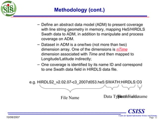
- 12. Methodology (cont.) – Define an abstract data model (ADM) to present coverage with line string geometry in memory, mapping He5/HIRDLS Swath data to ADM, in addition to manipulate and process coverage on ADM. – Dataset in ADM is a one/two (not more than two) dimension array. One of the dimensions is nTime dimension associated with Time and then mapped to Longitude/Latitude indirectly; – One coverage is identified by its name ID and correspond to one Swath data field in HIRDLS data file. e.g. HIRDLS2_v2.02.07-c3_2007d053.he5:SWATH:HIRDLS:O3 File Name Data Type Field name Swath name Data CSISS 10/08/2007 Center for Spatial Information Science and Systems Page 12
- 13. Methodology (cont.) B. Sub-setting operation for this particular kind of coverage – Domain sub-setting: • We use Time sequence parameter to process Domain sub-setting requested from user. The Domain subsetting by geographic Bounding Box will be implemented in future. The extent of nTime is about 24h one day that are restricted by HIRDLS data. Time granule is one second (the time frame and representation followed Aura/HIRDLS data production specification). CSISS 10/08/2007 Center for Spatial Information Science and Systems Page 13
- 14. Methodology (cont.) – Range sub-setting: • • Range sub-setting extracts data on non-nTime dimensions that are defined in ADM of coverage. It will depend on available number of dimensions and range of its value. The parameter that client requested for range subsetting is defined by WCS 1.1.0 spec. CSISS 10/08/2007 Center for Spatial Information Science and Systems Page 14
- 15. Methodology (cont.) – Output format: • For the reason of special coverage to be defined, the restore file format for outputting coverage adopts he5/Swath and NetCDF format. Another reason to adopt the he5/Swath is due to the specific requirement of AutoChem application. CSISS 10/08/2007 Center for Spatial Information Science and Systems Page 15
- 16. Methodology (cont.) C. Strategy of system design and development 1. Based-on object-oriented design and programming 2. WCS_T request messages follow OGC WCS_T 1.1.0 Specification. 3. Wrap he5 c interface into c++ implementation class 4. Platform of development, testing and running; 1. eclipse 2. Linux 5. Utilize open source software and tools 1. expat and scew libraries for XML parser 2. Hdf5 1.6.6, hdf-eos 5.1.10, netCDF 3.6.2 c/c++ lib 3. Other required c/c++ lib and tools CSISS 10/08/2007 Center for Spatial Information Science and Systems Page 16
- 17. Samples of system implementation • Current constraints of services routines: – Base data must be Aura/HIRDLS. – Domain sub-setting only supports Temporal Period request. – Output format only supports he5 and netCDF. – For the sake of research, services routines only complete GetCoverage operation up to now. CSISS 10/08/2007 Center for Spatial Information Science and Systems Page 17
- 18. Samples of system implementation (Cont.) • Samples for “Get Method”: – Sample 1: with Domain and Range sub-setting http://data.laits.gmu.edu:8080/cgi-bin/he5Swath? SERVICE=WCS&VERSION=1.1.0&REQUEST=GetCover age&IDENTIFIER=HIRDLS2_v2.02.07c3_2007d053.he5:SWATH:HIRDLS:O3&TimeSequence= 446257000.0000/446300000.0000&FORMAT=image/hdf eos5&RangeSubset=O3:NONE[Pressure[348.070,316.22 8,261.016]] CSISS 10/08/2007 Center for Spatial Information Science and Systems Page 18
- 19. Samples of system implementation (Cont.) – Sample 2: with Range sub-setting and without Domain sub setting http://data.laits.gmu.edu:8080/cgi-bin/he5Swath? SERVICE=WCS&VERSION=1.1.0&REQUEST=GetCover age&IDENTIFIER=HIRDLS2_v2.02.07c3_2007d053.he5:SWATH:HIRDLS:O3&FORMAT=image/ hdfeos5&RangeSubset=O3:NONE[Pressure[348.070,316. 228,261.016]] CSISS 10/08/2007 Center for Spatial Information Science and Systems Page 19
- 20. Samples of system implementation (Cont.) – sample 3: with Domain sub-setting and without Range sub-setting http://data.laits.gmu.edu:8080/cgi-bin/he5Swath? SERVICE=WCS&VERSION=1.1.0&REQUEST=GetCoverage&IDE NTIFIER=HIRDLS2_v2.02.07c3_2007d053.he5:SWATH:HIRDLS:O3&TimeSequence=44625700 0.0000/446300000.0000&FORMAT=image/hdfeos5 – sample 4: without Domain and Range sub-setting http://data.laits.gmu.edu:8080/cgi-bin/he5Swath? SERVICE=WCS&VERSION=1.1.0&REQUEST=GetCoverage&IDE NTIFIER=HIRDLS2_v2.02.07c3_2007d053.he5:SWATH:HIRDLS:O3&FORMAT=image/hdfeos5 CSISS 10/08/2007 Center for Spatial Information Science and Systems Page 20
- 21. Samples of system implementation (Cont.) • Post Method: – WCS XML Request Message CSISS 10/08/2007 Center for Spatial Information Science and Systems Page 21
- 22. Samples of system implementation (Cont.) - request <?xml version="1.0" encoding="UTF-8"?> <GetCoverage xmlns:xsi="http://www.w3.org/2001/XMLSchema-instance" xsi:schemaLocation="http://www.opengis.net/wcs/1.1 http://www.opengis.net/gml" xmlns="http://www.opengis.net/wcs/1.1" xmlns:ows="http://www.opengis.net/ows" xmlns:owcs="http://www.opengis.net/wcs/1.1/ows" xmlns:gml="http://www.opengis.net/gml" service="WCS" version="1.1.0"> <owcs:Identifier>HIRDLS2_v2.02.07-c3_2007d053.he5:SWATH:HIRDLS:O3</owcs:Identifier> <DomainSubset> <wcs:TemporalSubset> <wcs:TimePeriod> <wcs:BeginPosition>446257000.0000</wcs:BeginPosition> <wcs:EndPosition>446300000.0000</wcs:EndPosition> </wcs:TimePeriod> </wcs:TemporalSubset> </DomainSubset> <RangeSubset> <FieldSubset> <owcs:Identifier>O3</owcs:Identifier> <InterpolationType>None</InterpolationType> <AxisSubset> <Identifier>Pressure</Identifier> <Key>348.07000000</Key> <Key>316.22800000</Key> <Key>261.01600000</Key> </AxisSubset> </FieldSubset> </RangeSubset> <Output format="image/hdfeos5"> </Output> </GetCoverage> CSISS 10/08/2007 Center for Spatial Information Science and Systems Page 22
- 23. Samples of system implementation (Cont.) - response • WCS XML Respond <?xml version="1.0" encoding="UTF-8"?> <wcs:Coverages xmlns="http://www.opengis.net/ows/1.1" xmlns:xlink="http://www.w3.org/1999/xlink" xmlns:xsi="http://www.w3.org/2001/XMLSchema-instance" xmlns:wcs="http://www.opengis.net/wcs/1.1" xmlns:ows="http://www.opengis.net/ows" xmlns:owcs="http://www.opengis.net/wcs/1.1/ows" xmlns:gml="http://www.opengis.net/gml" xsi:schemaLocation="http://www.opengis.net/ows/1.1 ../owsCoverages.xsd"> <wcs:Coverage> <ows:Abstract>Coverage created from GetCoverage operation request to a WCS </ows:Abstract> <ows:Reference xlink:href="http://data.laits.gmu.edu:8080/NWGISS_Temp_Data/7bff494d0625-4ebd-a016-27336cc33306.he5" xlink:role="urn:ogc:def:role:WCS:1.1:coverage"/> </wcs:Coverage> </wcs:Coverages> 10/08/2007 CSISS Center for Spatial Information Science and Systems Page 23
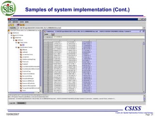
- 24. Samples of system implementation (Cont.) CSISS 10/08/2007 Center for Spatial Information Science and Systems Page 24
- 25. Samples of system implementation (Cont.) CSISS 10/08/2007 Center for Spatial Information Science and Systems Page 25
- 26. Samples of system implementation (Cont.) CSISS 10/08/2007 Center for Spatial Information Science and Systems Page 26
- 27. Discussion & Conclusion • Aura/HIRDLS data can be served effectively through the combination of powerful HDF-EOS and WCS – – – WCS provides standard interfaces to enable the access of Aura/HIRDLS data by geospatial applications. WCS_T provide a transparent, standard mechanism for the transaction of geospatial data in the Web environment. This WCS can be consumed by other Web services easily through its standard interfaces. It is realistic to chain different WCS into a complex composite service and better serve specific, advanced applications, e.g. application in sensor web project. CSISS 10/08/2007 Center for Spatial Information Science and Systems Page 27
- 28. Discussion & Conclusion • The work in future – – – To complete other required operations (e.g. getcapabilities, describeCoverage, transaction.) Provide support for coverage request with BBox parameters and one more coverage output. Provide support for composing BBox and Temporal Period request. CSISS 10/08/2007 Center for Spatial Information Science and Systems Page 28
- 29. Reference 1. OGC 06-083r8, 2006-10-17, “Web Coverage Service (WCS) Implementation Specification, Version: 1.1.0”. 2. OGC 2007-06-27, “Web Coverage Service (WCS) — Transaction operation profile, Version: 1.1.0”. 3. July 1, 2006, “A Short Guide for V 2.00 Level-2 Data from HIRDLS PI”, from http://daac.gsfc.nasa.gov/Aura/HIRDLS/documents/Shortguide-Level2data_InitialRelease.pdf . 4. "AutoChem Wiki." from http://en.wikipedia.org/wiki/Autochem. 5. OGC 00-106, “The OpenGIS® Abstract Specification Topic 6: The Coverage Type and its Subtypes , Version 4 ”. 6. 30 June 2006, “HIRDLS Version 2.0 Level 2 Data Description Quality Documents”, from http://daac.gsfc.nasa.gov/Aura/HIRDLS/documents/HIRDLS_D ata_Description_InitialRelease.pdf CSISS 10/08/2007 Center for Spatial Information Science and Systems Page 29
- 30. Acknowledgements • This study has been supported by two NASA-funded projects: NASA AIST-QRS-06-0026 (PI: Dr. John F. Moses, Co-I: Dr. Liping Di, Dr. Wayne Feltz, Dr. Jason Brunner, Dr. Robert Rabin) and NASA AIST-05-0064 (PI: Dr. Liping Di, Co-I: Dr. James Smith, Dr. David Lary). • This study is also partially supported by the National Basic Research Program (973 program) of China: 2006CB701300 (PI: Dr. Jianya Gong). CSISS 10/08/2007 Center for Spatial Information Science and Systems Page 30
- 31. Questions? CSISS 11/08/2007 Page LCenter for Spatial Information Science and Systems 31
- 32. Thanks CSISS 11/08/2007 Page LCenter for Spatial Information Science and Systems 32
Editor's Notes
- #14: The question is that it will conduct one more coverages outputting if use “BBox” or compose “BBox” with “Temporal period”. How to make decision the format of coverage outputting?).


![Introduction (Cont.)
2. Objectives
–
Final Goal:
•
To implement a Web Coverage Service (WCS) for describing and
delivering multidimensional geospatial coverage data in HDF-EOS
5/HDF-5 format. The services followed OGC WCS Specification 1.1.0.
[1]
•
–
The Web Coverage Service (WCS) implemented provides the
Transaction operation.[2] The transaction provides the flexibility of reserving derived results in standard geospatial services.
Phrases:
•
•
Phrase 1:
– Focus on Aura/HIRDSL L2(hdfeos5) base data;
– Implement general operations of WCS. i.e. getCoverage,
getCapabilites, DescribeCoverage…;
– Provide he5 Swath and netCDF responding to client’s request;
Phrase 2:
– Add Transaction operation;
– Provide Aura / plain hdf5 base data support;
CSISS
10/08/2007
Center for Spatial Information Science and Systems
Page 4](https://image.slidesharecdn.com/wcs4he5-final-140218100635-phpapp02/85/Implementation-of-OGC-Web-Coverage-Service-Using-HDF5-HDF-EOS5-as-the-Base-File-Format-4-320.jpg)
![Introduction (Cont.)
3. About Aura HIRDLS data [3]
–
–
–
–
–
HIRDLS is an infrared limb-scanning radiometer designed
to sound the upper troposphere, stratosphere, and
mesosphere to determine temperature;
HIRDLS measures the concentrations of O3, H2O, CH4,
N2O, NO2, HNO3, N2O5, CFC11, CFC12, ClONO2, and
aerosols;
Locations of polar stratospheric clouds and cloud tops.
The goals were to provide sounding observations with
horizontal and vertical resolution superior to that previously
obtained;
To observe the lower stratosphere with improved sensitivity
and accuracy; and to improve the understanding of
atmospheric processes through data analysis, diagnostics,
and use of two- and three-dimensional models.
CSISS
10/08/2007
Center for Spatial Information Science and Systems
Page 5](https://image.slidesharecdn.com/wcs4he5-final-140218100635-phpapp02/85/Implementation-of-OGC-Web-Coverage-Service-Using-HDF5-HDF-EOS5-as-the-Base-File-Format-5-320.jpg)
![Introduction (Cont.)
• About AutoChem [4]
– AutoChem is a NASA release software that constitutes an
automatic computer code generator and a documenter for
chemically reactive systems written by David Lary between
1993 and the present. It was designed primarily for modeling
atmospheric chemistry, and in particular, for chemical
data assimilation .
CSISS
10/08/2007
Center for Spatial Information Science and Systems
Page 6](https://image.slidesharecdn.com/wcs4he5-final-140218100635-phpapp02/85/Implementation-of-OGC-Web-Coverage-Service-Using-HDF5-HDF-EOS5-as-the-Base-File-Format-6-320.jpg)


![Methodology (cont.)
2. The difficulties to be solved
A. Representing, defining and restoring of the Line string
coverage [5]
•
The definition of OGC Coverage:
– GIS coverages (including the special case of Earth
images) are two- (and sometimes higher-) dimensional
metaphors for phenomena found on or near a portion of
the Earth’s surface.
– A coverage is a special case of (or a subtype of) feature.
– A feature with geometry has one or more properties
taking values that are OpenGIS geometries (as defined in
Topic 1, and in the Implementation Specifications.)
CSISS
10/08/2007
Center for Spatial Information Science and Systems
Page 10](https://image.slidesharecdn.com/wcs4he5-final-140218100635-phpapp02/85/Implementation-of-OGC-Web-Coverage-Service-Using-HDF5-HDF-EOS5-as-the-Base-File-Format-10-320.jpg)
![Methodology (cont.)
•
The coverage we used from HE5/HIRDLS is different from
what we met previously. Geolocation information is based on
line string geometry, in contrast to image and grid coverage.
The geolocation and other location information were mapped
by “Time” information indirectly.
(Source comes from [6])
10/08/2007
CSISS
Center for Spatial Information Science and Systems
Page 11](https://image.slidesharecdn.com/wcs4he5-final-140218100635-phpapp02/85/Implementation-of-OGC-Web-Coverage-Service-Using-HDF5-HDF-EOS5-as-the-Base-File-Format-11-320.jpg)



![Samples of system implementation (Cont.)
• Samples for “Get Method”:
– Sample 1: with Domain and Range sub-setting
http://data.laits.gmu.edu:8080/cgi-bin/he5Swath?
SERVICE=WCS&VERSION=1.1.0&REQUEST=GetCover
age&IDENTIFIER=HIRDLS2_v2.02.07c3_2007d053.he5:SWATH:HIRDLS:O3&TimeSequence=
446257000.0000/446300000.0000&FORMAT=image/hdf
eos5&RangeSubset=O3:NONE[Pressure[348.070,316.22
8,261.016]]
CSISS
10/08/2007
Center for Spatial Information Science and Systems
Page 18](https://image.slidesharecdn.com/wcs4he5-final-140218100635-phpapp02/85/Implementation-of-OGC-Web-Coverage-Service-Using-HDF5-HDF-EOS5-as-the-Base-File-Format-18-320.jpg)
![Samples of system implementation (Cont.)
– Sample 2: with Range sub-setting and without
Domain sub setting
http://data.laits.gmu.edu:8080/cgi-bin/he5Swath?
SERVICE=WCS&VERSION=1.1.0&REQUEST=GetCover
age&IDENTIFIER=HIRDLS2_v2.02.07c3_2007d053.he5:SWATH:HIRDLS:O3&FORMAT=image/
hdfeos5&RangeSubset=O3:NONE[Pressure[348.070,316.
228,261.016]]
CSISS
10/08/2007
Center for Spatial Information Science and Systems
Page 19](https://image.slidesharecdn.com/wcs4he5-final-140218100635-phpapp02/85/Implementation-of-OGC-Web-Coverage-Service-Using-HDF5-HDF-EOS5-as-the-Base-File-Format-19-320.jpg)


