SlideShare a Scribd company logo
Maps and the Geospatial Revolution
Lesson 3 – Lecture 1
Anthony C. Robinson, Ph.D
Lead Faculty for Online Geospatial Education
John A. Dutton e-Education Institute
Assistant Director, GeoVISTA Center
Department of Geography
The Pennsylvania State University
This content is licensed under a Creative Commons Attribution-NonCommercial 3.0 Unported License
Where are we now?
• Locating things used to be very difficult, and it was done using
time-intensive methods that weren’t very accurate
• You probably associate location technology with GPS –
– Global Positioning System, built by the U.S. military starting in the
1970’s
– Not invented by Apple or Google, believe it or not
• GPS is one example of a Global Navigation Satellite System
(GNSS)
– Others include the Russian GLONASS and EU Galileo system
Where are we now?
• It’s already common for consumer devices to use
GNSS to derive locations
– Often augmented with wifi hotspots and other signals
that combined can improve accuracy and coverage
• Consumer-grade stuff can locate positions to within
a few meters, but they can be off by hundreds of
meters in poor conditions
• Professional systems are used for surveying
property lines and other serious geo-tasks
Where are we now?
• A GPS-enabled device can give you a point location defined by
latitude and longitude coordinates
– My desk at home is 40.77004, 77.896744
• If I walked around my yard collecting multiple points, I could
create a polygon that represents the property I own
• If I collected points in a row between my couch and the fridge,
I’d have a line feature
• Points, lines, and polygons are the primary forms of spatial
vector data
The Earth from Above
• Virtual globe tools like Google Earth have
made images of the Earth easily accessible
• Most geographic image data comes from
satellites and airborne sensors, but you can
even make your own DIY Drone now
• Geographic image data is raster data, which
captures information by assigning values to
cells in a grid
The Earth from Above
• The size of raster grid cells determines how
much resolution you have for the image
The Earth from Above
• The science and technology associated with
imaging the Earth is called Remote Sensing
• It’s not just photographs – it can involve the
use of lasers (LIDAR) and infrared sensors
The Earth from Above
Source: Science@NASA: http://science.nasa.gov/science-news/science-at-nasa/2011/16may_groundtracks/
Source: USGS: http://coastal.er.usgs.gov/hurricanes/sandy/lidar/
Maps and the Geospatial Revolution www.coursera.org/course/maps
Twitter @MapRevolution
Online Geospatial Education @ Penn State www.pennstategis.com
This content is licensed under a Creative Commons Attribution-NonCommercial 3.0 Unported License

More Related Content

PPT
Geoeverything
PPT
Gis projects test
PPTX
Remote Sensing and its Application
PDF
Soil mapping , remote sensing and use of sensors in precision farming
PPT
C:\Documents And Settings\Sachink\Desktop\Shilpa Study\Gis Projects Test
PPTX
Aerospace and remote sensing
PPTX
Remote sensing in Plants
PDF
Iirs lecure notes for Remote sensing –An Overview of Decision Maker
Geoeverything
Gis projects test
Remote Sensing and its Application
Soil mapping , remote sensing and use of sensors in precision farming
C:\Documents And Settings\Sachink\Desktop\Shilpa Study\Gis Projects Test
Aerospace and remote sensing
Remote sensing in Plants
Iirs lecure notes for Remote sensing –An Overview of Decision Maker

Viewers also liked (7)

PDF
Maps and the Geospatial Revolution: Lesson 1, Lecture 2
PDF
Maps and the Geospatial Revolution: Lesson 3, Lecture 2
PDF
Maps and the Geospatial Revolution: Lesson 5, Lecture 2
PDF
Maps and the Geospatial Revolution: Lesson 2, Lecture 1
PDF
Maps and the Geospatial Revolution: Lesson 2, Lecture 2
PDF
Maps and the Geospatial Revolution: Lesson 4, Lecture 1
PDF
Maps and the Geospatial Revolution: Lesson 5, Lecture 1
Maps and the Geospatial Revolution: Lesson 1, Lecture 2
Maps and the Geospatial Revolution: Lesson 3, Lecture 2
Maps and the Geospatial Revolution: Lesson 5, Lecture 2
Maps and the Geospatial Revolution: Lesson 2, Lecture 1
Maps and the Geospatial Revolution: Lesson 2, Lecture 2
Maps and the Geospatial Revolution: Lesson 4, Lecture 1
Maps and the Geospatial Revolution: Lesson 5, Lecture 1
Ad

Similar to Maps and the Geospatial Revolution: Lesson 3, Lecture 1 (20)

PPTX
Introduction to spatial tech mac feb 2012
PPTX
GIS and Remote sensing CIvil Engg by Mrunmayee
PPT
Using Spatial Technologies in the Geography Classroom
PDF
Intro To Geospatial
PDF
Geospatial technologies, the evolution and impact on our daily life (by Nicol...
PDF
Geospatial Research At UCL
PPTX
(Research Project) Satellites : Applications in Topography
PPTX
GPS,GIS & REMOTE SENSING(NATURAL DISASTER MITIGATION AND MANAGEMENT).pptx
PPT
Laser-beams, spacecraft and archaeology; recent approaches to the recording, ...
PPTX
Presentation A.K Nigam sir (2) (1).pptx
PPTX
GIS_Geographical Information System & Global Positioning System in Geography
PPTX
Satellite and aerial surveys
PPTX
Introduction to Geoinformatics
PDF
Maps and the Geospatial Revolution: Lesson 1, Lecture 1
PPTX
4 h gps gis volunteer leader training
PPTX
4 h gps gis volunteer leader training
ODP
Spatial is Not Special ?
PPTX
Introduction to Physical Geography
PPT
Intro to GIS and Remote Sensing
Introduction to spatial tech mac feb 2012
GIS and Remote sensing CIvil Engg by Mrunmayee
Using Spatial Technologies in the Geography Classroom
Intro To Geospatial
Geospatial technologies, the evolution and impact on our daily life (by Nicol...
Geospatial Research At UCL
(Research Project) Satellites : Applications in Topography
GPS,GIS & REMOTE SENSING(NATURAL DISASTER MITIGATION AND MANAGEMENT).pptx
Laser-beams, spacecraft and archaeology; recent approaches to the recording, ...
Presentation A.K Nigam sir (2) (1).pptx
GIS_Geographical Information System & Global Positioning System in Geography
Satellite and aerial surveys
Introduction to Geoinformatics
Maps and the Geospatial Revolution: Lesson 1, Lecture 1
4 h gps gis volunteer leader training
Spatial is Not Special ?
Introduction to Physical Geography
Intro to GIS and Remote Sensing
Ad

Recently uploaded (20)

PDF
Abdominal Access Techniques with Prof. Dr. R K Mishra
PDF
Pre independence Education in Inndia.pdf
PDF
grade 11-chemistry_fetena_net_5883.pdf teacher guide for all student
PDF
Saundersa Comprehensive Review for the NCLEX-RN Examination.pdf
PDF
FourierSeries-QuestionsWithAnswers(Part-A).pdf
PDF
2.FourierTransform-ShortQuestionswithAnswers.pdf
PPTX
Introduction_to_Human_Anatomy_and_Physiology_for_B.Pharm.pptx
PDF
102 student loan defaulters named and shamed – Is someone you know on the list?
PDF
Supply Chain Operations Speaking Notes -ICLT Program
PPTX
Cell Types and Its function , kingdom of life
PDF
STATICS OF THE RIGID BODIES Hibbelers.pdf
PPTX
Pharmacology of Heart Failure /Pharmacotherapy of CHF
PPTX
GDM (1) (1).pptx small presentation for students
PDF
O7-L3 Supply Chain Operations - ICLT Program
PPTX
Microbial diseases, their pathogenesis and prophylaxis
PDF
TR - Agricultural Crops Production NC III.pdf
PDF
Basic Mud Logging Guide for educational purpose
PPTX
Final Presentation General Medicine 03-08-2024.pptx
PDF
Insiders guide to clinical Medicine.pdf
PDF
Chapter 2 Heredity, Prenatal Development, and Birth.pdf
Abdominal Access Techniques with Prof. Dr. R K Mishra
Pre independence Education in Inndia.pdf
grade 11-chemistry_fetena_net_5883.pdf teacher guide for all student
Saundersa Comprehensive Review for the NCLEX-RN Examination.pdf
FourierSeries-QuestionsWithAnswers(Part-A).pdf
2.FourierTransform-ShortQuestionswithAnswers.pdf
Introduction_to_Human_Anatomy_and_Physiology_for_B.Pharm.pptx
102 student loan defaulters named and shamed – Is someone you know on the list?
Supply Chain Operations Speaking Notes -ICLT Program
Cell Types and Its function , kingdom of life
STATICS OF THE RIGID BODIES Hibbelers.pdf
Pharmacology of Heart Failure /Pharmacotherapy of CHF
GDM (1) (1).pptx small presentation for students
O7-L3 Supply Chain Operations - ICLT Program
Microbial diseases, their pathogenesis and prophylaxis
TR - Agricultural Crops Production NC III.pdf
Basic Mud Logging Guide for educational purpose
Final Presentation General Medicine 03-08-2024.pptx
Insiders guide to clinical Medicine.pdf
Chapter 2 Heredity, Prenatal Development, and Birth.pdf

Maps and the Geospatial Revolution: Lesson 3, Lecture 1

  • 1. Maps and the Geospatial Revolution Lesson 3 – Lecture 1 Anthony C. Robinson, Ph.D Lead Faculty for Online Geospatial Education John A. Dutton e-Education Institute Assistant Director, GeoVISTA Center Department of Geography The Pennsylvania State University This content is licensed under a Creative Commons Attribution-NonCommercial 3.0 Unported License
  • 2. Where are we now? • Locating things used to be very difficult, and it was done using time-intensive methods that weren’t very accurate • You probably associate location technology with GPS – – Global Positioning System, built by the U.S. military starting in the 1970’s – Not invented by Apple or Google, believe it or not • GPS is one example of a Global Navigation Satellite System (GNSS) – Others include the Russian GLONASS and EU Galileo system
  • 3. Where are we now? • It’s already common for consumer devices to use GNSS to derive locations – Often augmented with wifi hotspots and other signals that combined can improve accuracy and coverage • Consumer-grade stuff can locate positions to within a few meters, but they can be off by hundreds of meters in poor conditions • Professional systems are used for surveying property lines and other serious geo-tasks
  • 4. Where are we now? • A GPS-enabled device can give you a point location defined by latitude and longitude coordinates – My desk at home is 40.77004, 77.896744 • If I walked around my yard collecting multiple points, I could create a polygon that represents the property I own • If I collected points in a row between my couch and the fridge, I’d have a line feature • Points, lines, and polygons are the primary forms of spatial vector data
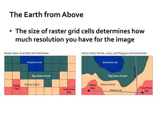
  • 5. The Earth from Above • Virtual globe tools like Google Earth have made images of the Earth easily accessible • Most geographic image data comes from satellites and airborne sensors, but you can even make your own DIY Drone now • Geographic image data is raster data, which captures information by assigning values to cells in a grid
  • 6. The Earth from Above • The size of raster grid cells determines how much resolution you have for the image
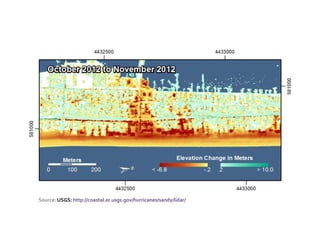
  • 7. The Earth from Above • The science and technology associated with imaging the Earth is called Remote Sensing • It’s not just photographs – it can involve the use of lasers (LIDAR) and infrared sensors
  • 8. The Earth from Above Source: Science@NASA: http://science.nasa.gov/science-news/science-at-nasa/2011/16may_groundtracks/
  • 11. Maps and the Geospatial Revolution www.coursera.org/course/maps Twitter @MapRevolution Online Geospatial Education @ Penn State www.pennstategis.com This content is licensed under a Creative Commons Attribution-NonCommercial 3.0 Unported License