


![The water quality parameters that were analysed are given
GWQI = Anti log[∑Wn=1log10qn]
Groundwater GWQI
Very good 0-25
Good 25-50
Moderate 50-75
Poor 75-100
Very poor 100-125
Unfit >125
Singh, C.K., Shashtri, S.,
Mukherjee, S. et al. Application of
GWQI to Assess Effect of Land
Use Change on Groundwater
Quality in Lower Shiwaliks of
Punjab: Remote Sensing and GIS
Based Approach. Water Resour
Manage 25, 1881–1898 (2011)](https://image.slidesharecdn.com/creditseminar-210720180341/85/APPLICATION-OF-REMOTE-SENSING-AND-GIS-IN-AGRICULTURE-48-320.jpg)


![Estimation of Soil Erosion Using Remote
Sensing and GIS, Its Valuation and Economic
Implications on Agricultural Production
CASE STUDY : 6
E30 model for estimating soil
erosion using NDVI
The soil erosion model given in
Equation 1 was used to estimate the
annual rate of soil erosion in the Mae Ao
watershed (Honda, 1993, 1996 and
1998). This model is mainly governed
by slope gradient and vegetation index
and the annual soil erosion rate (E) is
defined as:
E = E30 (S/S30)0.9
(1)
where S= gradient of the point under
consideration, S30= tan (30), and E30=
rate of soil erosion at 30 slope and
defined as given below
The Normalized Difference Vegetation Index
(NDVI) as defined by Equation 3 was used to
assess the vegetative cover. To avoid negative
values and for easy handling of digital data,
NDVI value obtained for Landsat-TM data
(30m spatial resolution) were re-scaled as
shown in Equation 3.
E30 Exp[(log0.132-log17.12)
NDV Im ax NDV Imin
( NDVI NDV Imin )
Log17.12] …………..(1)
NDVI = [( Band 4 - Band 3 ) + 1] *100 …….(2)
Band 4 + Band 3
The maximum and minimum rates of soil
erosion at 30◦ slope in the study area
collected from field stations were
17.12 mm/year and 0.132 mm/year in the
study area as shown in Equation 2](https://image.slidesharecdn.com/creditseminar-210720180341/85/APPLICATION-OF-REMOTE-SENSING-AND-GIS-IN-AGRICULTURE-53-320.jpg)
![Two Landsat TM images from 1992 and 1996 were used in this study and the necessary
radiometric correction was done by using the 1996 Landsat TM data as the base image
linear interpolation was carried out to make radiometric correction of 1992 Landsat TM
data.
Corrected NDVI of 1992 =
[( Maximum96 Minimum96
)
Maximum92 Minimum92
( NDVI 92 Minimum92 )]
Minimum96 …….(3)
Landsat-TM data
NDVI
E30 value
Soil erosion estimation
Soil erosion map
Topographic map
DEM
Slope gradient
Soil Erosion in each
soil-mapping units
NPK content in each
soil-mapping units Loss of NPK from each
soil-mapping units
Market price of NPK Cost of lost NPK in
each soil-mapping units
Cost of soil erosion in
the study area
Methodology for estimating the
annual soil erosion rate
Methodology for estimating the
cost of soil erosion](https://image.slidesharecdn.com/creditseminar-210720180341/85/APPLICATION-OF-REMOTE-SENSING-AND-GIS-IN-AGRICULTURE-54-320.jpg)


APPLICATION OF REMOTE SENSING AND GIS IN AGRICULTURE
- 1. Credit Seminar on APPLICATION OF REMOTE SENSING AND GIS IN AGRICULTURE SPEAKER LAGNAJEET ROY 2019-AMJ-34 Department of Agrometeorology
- 2. CONTENTS 1. What is Remote Sensing a) Definition b) Components c) Process d) Types 2) What is GIS and its relationship with Remote Sensing a) Collection of data b) Data interpretation and Analysis c) Mapping and digitizing d) Georeferencing e) Raster and vector models f) True & False color composite 3) Case studies 4) Summary and Conclusion
- 3. What is Remote Sensing Remote sensing can be defined as the science, technology and art of acquiring information about an object which are not in the physical contact with the object itself. -Sahu and Solanki Source – GIS Geography •DEFINITION:
- 4. Components of Remote Sensing 1. A source of Energy 2. Interactions of energy with the atmosphere 3. Interactions of energy with earth surface 4. A sensor with platform Department of Agricultural Meteorology, CCS HAU Hisar
- 5. SOURCE OF ENERGY The sun provides a very convenient source of energy for remote sensing. The sun's energy is either reflected, as it is for visible wavelengths, or absorbed and then re-emitted, Remote sensing systems which measure energy that is naturally available are called passive source. Ex: MODIS (Moderate Resolution Imaging Spectroradiometer)/ Sentinel-2 Active source, on the other hand, provide their own energy source for illumination. The sensor emits radiation which is directed toward the target to be investigated. The radiation reflected from that target is detected and measured by the sensor. Ex: PALSAR-2 Source- GIS and Earth
- 6. Ok so we read about energy, so what is it? The answer is Electro Magnetic Radiation and different Kind (Wavelength and Frequency) of Radiation emit from the source As we know that planks law is E= hf f=c/ λ That shows wavelength and frequency are inversely proportional Now we will se the different Radiation that are used in Remote sensing SOURCE - WIKIPEDIA
- 7. Interaction with the atmosphere Before radiation used for remote sensing reaches the Earth's surface it has to travel through some distance of the Earth's atmosphere. Particles and gases in the atmosphere can affect the incoming light and radiation. These effects are caused by the mechanisms of scattering and absorption. Source: NASA By interacting with atmosphere: 1) It helps in detection of cyclone 2) Helps in detection of cloud and its type from where it is easy to predict rainfall or hail storm 3) It helps in detecting the amount of Dust particle present in atmosphere specially after dust storm or any volcano eruption in any region
- 8. Atmospheric Window and its importance in remote sensing: Some types of electromagnetic radiation easily pass through the atmosphere, while other types do not. The ability of the atmosphere to allow radiation to pass through it is referred to as its transmissivity, and varies with the wavelength of the radiation. The gases(O3, CO2, Water vapour,CH4) that comprise our atmosphere absorb radiation in certain wavelengths while allowing radiation with differing wavelengths to pass through. In contrast to the absorption bands, there are areas of the electromagnetic spectrum where the atmosphere is essentially transparent (with no absorption of radiation) to specific wavelengths. These regions of the spectrum or wavelengths are known as "atmospheric windows“. Visible light and radio waves can pass relatively freely through the atmosphere, while X-Rays can not.
- 9. Interaction with the earth surface: When electromagnetic energy reaches the Earth's surface there are three possible energy interactions with the surface feature: Reflection: occurs when radiation "bounces" off the target and is redirected Absorption: occurs when radiation (energy) is absorbed into the target Transmission: occurs when radiation passes through a target EI(λ) = ER(λ) + EA(λ) + ET(λ) Where: EI(λ) = Incident energy (from sun) ER(λ) = Reflected energy EA(λ) = Absorbed energy ET(λ) = Transmitted energy •Vegetation and soils can reflect approximately 30-50% of the incident energy (across the entire EM spectrum) • while water on the other hand reflects only 10% of incident energy. Water reflects most of this in the visible range, minimal in the NIR( Near Infrared) and beyond 1.2 μm (mid-infrared) water absorbs nearly all energy.
- 10. Reflectance Reflection occurs when incoming energy bounces off a surface and is reflected back. The amount of reflection varies with: •Wavelength of Energy •Geometry of the Surface •Surface Materials The total quantity of incoming energy (light) from the sun is known as irradiance. Satellites measure radiance (brightness), or the amount of light. Reflectance is the percent of incoming incident energy that is reflected. This is always measured as a function of wavelength and is given as a percent. Spectral Reflectance ρλ = ER(λ) / EI(λ) or % Reflectance = Amount of Reflected Energy /Total Energy x 100
- 11. Remote sensing and Plants primary target in agriculture Spectral signatures of crops and soil (Kyllo, 2003). When electromagnetic energy from the sun strikes plants, the energy will be reflected, absorbed, or transmitted The relationship between reflected, absorbed and transmitted energy is used to determine spectral signatures of individual plants Spectral signatures are unique to plant species.
- 12. SENSOR and PLATFORM: Platforms refer to the structures or vehicles on which remote sensing instruments are mounted Ground based - To study properties of a single plant or a small patch of grass, it would make sense to use a ground based instrument. Airborne - At present, airplanes are the most common airborne platform. The whole spectrum of civilian and military aircraft are used for remote sensing applications. Satellite -- The most stable platform aloft is a satellite, which is spaceborne. There are two types of satellite: Geostationary satellite and Sun synchronous satellite SOURCE- REMOTE SENSING TECHNOLOGIES FOR POST-EARTHQUAKE DAMAGE ASSESSMENT: A CASE STUDY ON THE 2016 KUMAMOTO EARTHQUAKE BY Fumio YAMAZAKI and Wen LIU
- 13. SENSOR ACTIVE Imaging Non- imaging PASSIVE Imaging Non- imaging BASED ON ILLUMINATION Sensor Near UV region Visible region Infrared region Microwave region Conventional camera Panchromatic, vidicon camera Radiometer , Optical mechanical scanner Multi spectral scanner, thematic mapper, Radiometer BASED ON SPECTRAL REGIONS
- 14. When we come to know about sensor as the image is digital resolution of a system refers to its ability to record and display fine details and images are defined in scale. RESOLUTION Spatial resolution Spectral resolution Radiometric resolution Temporal resolution It refers the size of smallest possible feature can be detected (PIXEL). It depends upon IFOV of the sensor Lower the resolution clear the picture It characterizes the ability of the sensor to resolve energy received in a given spectral bandwidth to determine different constituent of earth surface( location) It mainly define that how often the image is collected? That shows how many time the satellite crossed a specific region in a specific time period To distinguish fine variations in the radiance values of different objects help in measuring dark areas water/shadow
- 15. First the electromagnetic radiation emitted from the source The radiation goes through atmosphere and interact with earth surface ( Crop, soil , water bodies etc.) Next those surface materials Reflect (Specular or Diffused) some amount of radiation and the other parts were Absorbed or transmitted The reflected radiation come back to the sensor that is placed on a platform Different types of sensors are specialized to detect different wave length bands of radiation The reflected EMR is different for different bodies as known as spectral reflectance The photographic system (identify soil types, plant types) and the scanning system, Microwave system of sensor help to collect data The images we obtained by sensors are digital in nature and it consist of large no. of pixels But we didn’t get the minute specification in those objects but there is GIS… Process of remote sensing
- 16. RELATIONSHIP BETWEEN REMOTE SENSING AND GIS (Geographic information system) REMOTE SENSING GIS Provide data input Different software input Ultimate Output
- 17. This is how both remote sensing and GIS work in Agriculture A A. Source B. Light coming to plants C. Plant D. Reflected energy sensed by a sensor in satellite E. It send information to ground station F. Using computer and software's to analyze the data G. Finally reliable info. Is given to the farmer that make their farming easy Source- GIS and Earth observation
- 18. GIS (Geographic information system) “A GIS is a computer-based system that provides the following four sets of capabilities to handle geo- referenced data: - Input - Data management (storage and retrieval) - Manipulation and analysis - Output.” (Aronoff, 1989) GIS FUNCTIONAL MODULES Data input Data base Query and analysis Output and visualization
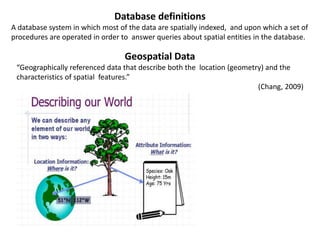
- 19. Database definitions A database system in which most of the data are spatially indexed, and upon which a set of procedures are operated in order to answer queries about spatial entities in the database. Geospatial Data “Geographically referenced data that describe both the location (geometry) and the characteristics of spatial features.” (Chang, 2009)
- 20. Components of GIS Hardware + Software + Data + People = GIS SOURCES OF INPUT DATA LIDAR Photogra mmetry GPS Remote sensing Hard copy maps Total Stations
- 21. Black and White • : Older and lower cost surveys are collected on black and white media Color: • More recent or higher cost aerial photo surveys are on color media Infrared: • Primary use is vegetation studies as vegetation is a very strong reflector of infrared radiation. AERIAL PHOTOGRAPHY (Main source of data in Agriculture) 1) collection of measurements from aerial photos in the preparation of maps (2) To determine land-use, environmental conditions, and geologic information (3)Aerial photos often display a high degree of radial distortion that must be corrected. GIS is used then.
- 22. HOW WE COLLECT DATA NOW? Manually digitizing from image or map sources • manually drawn maps • legal records • coordinate lists with associated tabular data • Aerial photographs Field coordinate measurement • Coordinate Surveying GPS Image data • Manual or automated classification • direct raster data entry DATA SOURCES and INPUT
- 23. • Scan map or image • If image not referenced, collect ground coordinates of control points • Digitize control points (tics, reference points, etc.) of known location • Transform (register) image to known coordinate system • Digitize feature boundaries in stream or point mode. • Edit Digitizing in GIS is the process of converting geographic data either from a hardcopy or a scanned image into vector data by tracing the features. Definition Manual digitization Coordinate geometry Global positioning system Geocoding Heads up digitizing Heads-up digitizing of building outlines performed in ArcMap10
- 24. Georeferencing is the process of defining exactly where on the earth’s surface an image or raster dataset was created. Georeferencing means that the internal coordinate system of a digital map or aerial photo can be related to a ground system of geographic coordinates. A georeferenced digital map or image has been tied to a known Earth coordinate system, so users can determine where every point on the map or aerial photo is located on the Earth's surface. Georeferencing in the digital file allows basic map analysis to be done, such as pointing and clicking on the map to determine the coordinates of a point, to calculate distances and areas, and to determine other information. The relevant coordinate transforms are typically stored within the image file (GeoPDF and GeoTIFF are examples of georeferenced file formats), though there are many possible mechanisms for implementing georeferencing.
- 25. Data Preparation for Geologic Mapping Preparing digital base map data (i.e. downloadable or previously stored thematic, topographic or remotely sensed data, or data that you digitize, scan and georeference); Creating a database and/or individual files to store data that will be gathered in the field (e.g. the locations and descriptive attributes of plant units, soil plant unit contacts, and measured attitudes) Creating a map that is ready for editing in the field
- 26. Image Processing Geodatasets can be derived from digital imagery. Most commonly satellite imagery is utilized in a process called supervised classification in which a user selected a sampling of pixels for which the user knows the type (vegetation species, land use, etc). Using a classification algorithm, remote sensing software such as ERDAS or ENVI classifies a digital image into these named categories based on the sample pixels. In contrast to the other methods discussed, supervised classification results in a raster dataset. Image restoration(Preprocessing), Image enhancement, classification and information extraction. Attribute data is information appended in tabular format to spatial features. The spatial data is the where and attribute data can contain information about the what, where, and why. ATTRIBUTE DATA Character Floating Integer Database management system: Info, dBase, Oracle, Informix, SYBASE, Access, FoxPro etc.
- 27. Spatial data models Two fundamental approaches: Raster model Vector model
- 28. Raster model The entity information is explicitly recorded for a basic data unit (cell, grid or pixel) Rasters can be used to show rainfall trends over an area, or to depict the fire risk on a landscape. This satellite image looks good when using a small scale... ...but when viewed at a large scale you can see the individual pixels that the image is composed of.
- 29. vector model • In a vector-based GIS data are handled as: – Points – Lines – Areas X,Y coordinate X,Y coordinate pair + label series of points line(s) forming their boundary (series of polygons) line feature area feature point feature
- 30. vector model Layers in an vector-based model
- 31. Standard overlay operators take two input data layers; assume they are georeferenced in the same system; overlap in study area. If either condition is not met, the use of an overlay operator is senseless. The principle is to: compare the characteristics of the same location in both data layers, and to produce a new output value for each location. Overlay operation
- 32. Jorhat city map Jorhat district map Jorhat road map Jorhat tehsil(Block) map Jorhat railway map
- 33. Natural or True Color Composites A natural or true color composite is an image displaying a combination of the visible red, green and blue bands to the corresponding red, green and blue channels on the computer display. Natural color images can be low in contrast and somewhat hazy due the scattering of blue light by the atmosphere. False Color Composites False color images are a representation of a multispectral image produced using any bands other than visible red, green and blue as the red, green and blue components of the display. False color composites allow us to visualize wavelengths that the human eye can not see (i.e. near-infrared and beyond).
- 34. Different Indices used in agriculture To define different characteristics in agricultural domain from vegetation to water or from soil to stress different index are used to define the condition in a simple manner that we can get from here.
- 35. Crop water stress mapping for site-specific irrigation by thermal imagery and artificial reference surfaces CASE STUDY: 1 Ground-based measurements were obtained during the summer of 2007 at a commercial cotton (Gossypium hirsutum x barbadense hybrid c.v. Acalpi) field in the Hula Valley of Israel. The soil at the site is a brown alluvial hydromorphic gromosol, and the climate is Mediterranean. The field was selected as an experimental site from previous observations of variable crop development, apparently related to very variable soil water-holding characteristics caused by the spatially variable alluvial deposits Infrared scanner mounted on a high pass sprayer False color IR image of a cotton row: a location marker and plant height measuring stick and b leaf water potential (LWP) sampling points
- 36. Cotton CWSI ( Crop water stress index) maps of the field monitored in the Hula Valley acquired on six separate days by ground survey in 2007. The LWP (Leaf water potential) sampling points for 18 June are shown in map
- 37. Water stress map of a peanut field during irrigation on 20 August 2007. Mean CWSI values are indicated ahead and behind the lateral move position (arrow) Water stress map of a drip irrigated process tomato field on 20 August 2007 Water stress map of a cotton field before last irrigation on 20 August 2007. Arrows indicate lateral move positionand pivoting directions of the irrigation rig. Numbers are the mean CWSI levels for the East and West parts of the field. The bold polygon marks the ground monitored part of the field
- 38. Water stress map of a center pivot irrigated cotton field after the last irrigation on 20 August 2007. Scattered line and arrow indicate final pivot position and turning directions of the irrigation rig Mean crop stress levels (CWSI) and their distribution for the August 20 aerial survey fields Meron, M., Tsipris, J., Orlov, V., Alchanatis, V., & Cohen, Y. (2010). Crop water stress mapping for site- specific irrigation by thermal imagery and artificial reference surfaces. Precision agriculture, 11(2), 148-162. When farmer come to know about the water stress in the specific position of his field then he can give irrigation according to the need of the crop to reduce crop failure and thus remote sensing and GIS provided the information to the farmer
- 39. CASE STUDY - 2 RESEARCH PROPOSAL: Application of remote sensing and GIS for acreage estimation of wheat This study was conducted in five districts situated in central part of Maharashtra i.e. Pune, Solapur, Ahmednagar, Beed and Osmanabad wherein spatially, extensive and contiguous sites contribute to wheat production Location of study : Multi-date, multispectral satellite images of IRS- P6, AWiFS (Advanced Wide Field Sensor) Sensor for five consecutive months of wheat season (October/November/December /January/February) of the year 2012- 13 were used for this study (Table 1). Rectangular subset images covering the study area were obtained and processed in ERDAS (Earth Resources Data Analysis System) Imagine to generate Normalized Difference Vegetation Index (NDVI) images on all the dates of satellite pass. The study area and location of ground truth stations
- 40. •Images of Normalized difference Vegetation Index (NDVI) on all the dates of pass were generated using ERDAS Imagine software and stack was prepared •Graphs of NDVI values for different dates of satellite image acquisition were plotted for rabi sorghum, wheat, sugarcane and other areas. These plots represent Reference Temporal Spectral Profile (RTSPs) of the respective class •The signature file so generated was used to obtain Temporal Spectral Profile (TSPs) for each class. These TSPs were compared visually with RSTP of wheat crop and the related classes were assigned as wheat crop Classified Image after unsupervised classification The classified image obtained after unsupervised classification is shown. It was found that TSP of 15 classes was matching with RTSP of wheat. The images showing only wheat crops (recoded images) in the subset area were obtained. The district wise pixel count of wheat crop was obtained by applying zonal attributes/majority count function of ArcGIS. For this process, option of intersection /union and ignore zero values was selected.
- 41. Area under wheat crop in the study area was estimated by remote sensing as 189481 ha against actual area of 172600 ha reported by Department of Agriculture showing 9.78 percent over estimation. This may be because of similar spectral profiles of coexisting crops like oats. Wheat being irrigated crop, soil moisture affects the reflectance of crop. Lowest variation of 6.31% was observed in Ahmednagar district whereas highest variation 12.66% was observed in Pune district. Crop District RS Estimat es (ha DOA estimates (ha) Deviation (%) Ahmednagar 41357 38900 6.31 Pune 59708 53000 12.66 Wheat Solapur 30861 28800 7.16 Beed 31805 27700 11.21 Osmanabad 26750 24200 10.53 189481 172600 9.78 RESULTS AND DISCURSSION Pimpale et al., International Journal of Engineering, Business and Enterprise Applications, 12(2), March-May 2015, pp. 167-171
- 42. Software Used ERDAS IMAGINE 9.0, ARC GIS-9.3 Application of Remote Sensing & GIS in Crop Information System – a case study of Paddy monitoring in Jamalpur Block METHODOLOGY CASE STUDY - 3
- 43. RICE TYPES CULTIVATING SEASON AUS JULY-AUGUST AMAN Generally DECEMBER-JANUARY BORO MARCH-MAY six classes derived from that image, mainly agricultural land, vegetative land, Water logged area, Flood prone area, Water bodies and Built-up land are shown It is easy to identify after it has been processed with NIR band of Landsat TM data The secondary data has been collected from the ADA office of Jamalpur. These data obtained to show the production curve of different types of rice and the change of rice cultivated area in the last five years Land use and Land cover map of Jamalpur Block
- 44. SPATIAL DISTRIBUTION OF AMAN DERIVED FROM JANUARY 2010 IMAGE SPATIAL DISTRIBUTION OF AUS DERIVED FROM JULY 2010 IMAGE : SPATIAL DISTRIBUTION OF BORO DERIVED FROM APRIL 2010 IMAGE YEAR AUS AMAN BORO Production Cultivated area (hector) Production Cultivated area (hector) Production Cultivated area (hector) 2007- 08 47600 8,300 41570 14,200 46894 3,800 2008- 09 47350 8,000 33533 12,000 31675 5,000 2009- 10 50300 8,100 42484 12,000 38979 400 2010- 11 40900 7,500 39618 12,300 40621 1,080 Variation of Rice cultivable area Variation of Rice production Pani, S., Chakrabarty, A., & Bhadury, D. S. (2014). Application of Remote Sensing & GIS in Crop Information System–a case study of Paddy monitoring in Jamalpur Block. IOSR Journal of Agriculture and Veterinary Science (IOSR-JAVS) e-ISSN, 2319-2380.
- 45. Application of GWQI to Assess Effect of Land Use Change on Groundwater Quality in Lower Shiwaliks of Punjab: Remote Sensing and GIS Based Approach CASE STUDY :4 Study area and its geomorphology study area was divided into grids of size 10 × 10 km2 Samples were collected on the basis of spectral signature as observed on satellite image from each grid (22 SAMPLES) The water samples were collected from nearly same depth (35∼40 m). The pH, Electrical conductivity and Total dissolved solids (TDS) meter (HANNA) were used to measure pH, EC and TDS in the field. The samples were filtered using vacuum filtration unit. and analyzed using atomic absorption spectrophotometer The study was carried out with the help of topographic sheets, Garmin Global positioning system (GPS) and ground truthing and then GIS for map making
- 46. The landsat image of the year 1989 procured from United States Geological Survey (USGS) and the Linear imaging scanning system (LISS) III (geo-coded) satellite image of December, 2006 acquired from National Remote Sensing Centre (NRSC), Hyderabad had been used for the present study. In addition, toposheets on 1:50,000 scales procured from Survey of India (SOI), Dehradun, were used for geo- referencing the satellite images . The geographical coordinates of various LULC classes were recorded using GPS The image was re-projected into World Geodetic System 1984 (WGS-84) spheroid and datum, zone 43 North of the UTM projection. The classified image was finally recoded into 12 classes
- 47. a Landsat data of 1989 (bands 4, 3, 2 and 1) and land use/land cover of study area. b IRS LISS III data of 2006; bands 3, 2, and 1) and land use/land cover of study area Class Area in km2 Area in km2 in 1989 in 2006 River 33.17 27.32 Settlement 17.56 111.23 Cropland 882.09 690.84 Fallow land 361.03 649.86 Dense forest 487.88 335.66 Salt affected land 11.70 21.46 Canal 13.66 13.66 Water body 17.56 10.73 Seasonal streams 33.17 21.46 Plantation 33.17 12.68 Land with scrub 17.56 52.69 Land without scrub 62.44 23.41 Area covered by LULC classes in year 1989 and 2006
- 48. The water quality parameters that were analysed are given GWQI = Anti log[∑Wn=1log10qn] Groundwater GWQI Very good 0-25 Good 25-50 Moderate 50-75 Poor 75-100 Very poor 100-125 Unfit >125 Singh, C.K., Shashtri, S., Mukherjee, S. et al. Application of GWQI to Assess Effect of Land Use Change on Groundwater Quality in Lower Shiwaliks of Punjab: Remote Sensing and GIS Based Approach. Water Resour Manage 25, 1881–1898 (2011)
- 49. DEVELOPMENT OF AN AIRBORNE REMOTE SENSING SYSTEM FOR CROP PEST MANAGEMENT: SYSTEM INTEGRATION AND VERIFICATION CASE STUDY:5 The MS‐4100 is currently a Geospatial Systems, Inc. product. It is a multi‐spectral HDTV (High Definition Television) format 3‐CCD (Charge‐Coupled Device) color/ CIR digital camera MS‐4100 spectral configurations RGB Red (660 nm with 40‐nm bandwidth), Green (540 nm with 40‐nm bandwidth), and Blue (460 nm with 45‐nm bandwidth) ‐color imaging CIR Red (660 nm with 40‐nm bandwidth), Green (540 nm with 40‐nm bandwidth), and NIR (800 nm with 65‐nm bandwidth) ‐color infrared imaging RGB/CI R RGB and CIR in a single camera Multi‐spectral Custom spectral configuration to customer specifications STUDY AREA
- 50. An image of the cotton field on 20 September 2007 illustrates the RMS values of seven georeferenced images acquired using the camera control system with automatic control of roll, pitch, and yaw camera stabilization during the flights for this research. With the flight altitude of 2600 m, the image resolution was 1.56 m/pixel for the MS‐4100 camera. RGB digital image and georeferenced image with overlay of GIS polygon of the big pivot west field.
- 51. Reflectance = H * Radiance / Irradiance The relationship is pixel radiance divided by solar irradiance illuminating the target (H = 3.1416): By ground truth field inspection, it was discovered that a number of abandoned irrigation structures remained in Region A. Region B was infested with cotton root rot disease A B we found that the images of NIR and red bands indicated the existence of root rot regions. The green band showed mostly noise and did not present visual differences. It appears by subjective evaluation of that the NIR and red images and possible band combinations such as NIR/red ratio and NDVI (Normalized Difference Vegetation Index) are probably sufficient to identify the region of root rot infestation CIR RED NIR GREEN CIR AOI and individual band AOI images
- 52. 8-20-07 9-14-07 9-20-07 9-27-07 10-2-07 10-5-07 10-11-07 NIR images of the root rot infested region on different dates. Lan, Y., Huang, Y., Martin, D. E., & Hoffmann, W. C. (2009). Development of an airborne remote sensing system for crop pest management: system integration and verification. Applied Engineering in Agriculture, 25(4), 607-615. This paper show us the respective day to day variation in cotton plant after cotton root rot disease. The no of days increasing that show in this NDVI map that the dark patches are increasing and that showing the disease infestation vigourity and that help farmer if he know about this situation.
- 53. Estimation of Soil Erosion Using Remote Sensing and GIS, Its Valuation and Economic Implications on Agricultural Production CASE STUDY : 6 E30 model for estimating soil erosion using NDVI The soil erosion model given in Equation 1 was used to estimate the annual rate of soil erosion in the Mae Ao watershed (Honda, 1993, 1996 and 1998). This model is mainly governed by slope gradient and vegetation index and the annual soil erosion rate (E) is defined as: E = E30 (S/S30)0.9 (1) where S= gradient of the point under consideration, S30= tan (30), and E30= rate of soil erosion at 30 slope and defined as given below The Normalized Difference Vegetation Index (NDVI) as defined by Equation 3 was used to assess the vegetative cover. To avoid negative values and for easy handling of digital data, NDVI value obtained for Landsat-TM data (30m spatial resolution) were re-scaled as shown in Equation 3. E30 Exp[(log0.132-log17.12) NDV Im ax NDV Imin ( NDVI NDV Imin ) Log17.12] …………..(1) NDVI = [( Band 4 - Band 3 ) + 1] *100 …….(2) Band 4 + Band 3 The maximum and minimum rates of soil erosion at 30◦ slope in the study area collected from field stations were 17.12 mm/year and 0.132 mm/year in the study area as shown in Equation 2
- 54. Two Landsat TM images from 1992 and 1996 were used in this study and the necessary radiometric correction was done by using the 1996 Landsat TM data as the base image linear interpolation was carried out to make radiometric correction of 1992 Landsat TM data. Corrected NDVI of 1992 = [( Maximum96 Minimum96 ) Maximum92 Minimum92 ( NDVI 92 Minimum92 )] Minimum96 …….(3) Landsat-TM data NDVI E30 value Soil erosion estimation Soil erosion map Topographic map DEM Slope gradient Soil Erosion in each soil-mapping units NPK content in each soil-mapping units Loss of NPK from each soil-mapping units Market price of NPK Cost of lost NPK in each soil-mapping units Cost of soil erosion in the study area Methodology for estimating the annual soil erosion rate Methodology for estimating the cost of soil erosion
- 55. By calculating thevalue for each pixel using Equation 1, soil erosion from each pixel with a different slope was calculated using Equation 1. A raster map of slope gradient was prepared with a pixel size of 30m (same as Landsat-TM data), using a Digital Elevation Model (DEM) to provide the slope information for Equation 1 Soil erosion map showing average annual rate of erosion in 1992. Soil erosion map showing average annual rate of erosion in 1996 The average annual rate of soil erosion in the study area in1992 and 1996 is shown in Figure 3 and Figure 4, respectively. The average annual soil erosion rate in the study area decreased from 1.24 mm/year in 1992 to 0.91 mm/year in 1996. plantation program taken up Hazarika, M. K., & Honda, K. (2001). Estimation of soil erosion using remote sensing and GIS: Its valuation and economic implications on agricultural production. Sustaining the global farm, 1, 1090-1093.
- 56. RESULT AND CONCLUSION Remote sensing and GIS combination of both of them help in agricultural activities. It is easy to get the information about that area where human cannot check the condition everyday and help in gathering the data From disease estimation to stress factor due to water from ground water quality index to acreage estimation in various way agriculture is being profited by the application of remote sensing and GIS in agriculture The application of those software or techniques are very new to the agriculture domain still much more exploration is needed in this part New software are developing in different parts of the world and remote sensing,GIS is used in various other factors not only in agriculture like any kind of mapping pattern may be from the area estimation from Australian bush fire to the statistical analysis of covid 19 affected people. Today farmers are understanding the beneficiaries of this kinds of techniques to the farm field which help in increasing productivity that will help future generation as technology is a hype in traditional system of farming